
The Broad Street Line (BSL), also known as the Broad Street subway (BSS), Orange Line, or Broad Line, is a subway line owned by the city of Philadelphia and operated by the Southeastern Pennsylvania Transportation Authority (SEPTA). The line runs primarily north-south from the Fern Rock Transportation Center in North Philadelphia through Center City Philadelphia to NRG station at Pattison Avenue in South Philadelphia; the latter station provides access to the stadiums and arenas for the city's major professional sports teams at the South Philadelphia Sports Complex, about a quarter mile away. It is named for Broad Street, under which the line runs for almost its entire length.

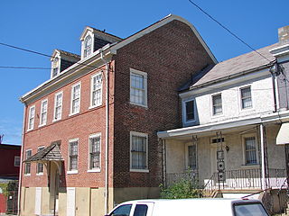
Fishtown is a neighborhood in the River Wards section of Philadelphia, Pennsylvania, United States. Located northeast of Center City Philadelphia, its borders are somewhat disputed today due to many factors, but are roughly defined by the triangle created by the Delaware River, Frankford Avenue, and York Street. Some newer residents expand the area to Lehigh Avenue, while some older residents shrink the area to Norris Street. It is served by the Market–Frankford Line rapid transit subway/elevated line of the SEPTA system. Fishtown is a largely working class Irish Catholic neighborhood, but has recently seen a large influx of young urban professionals and gentrification.

The Market–Frankford Line (MFL), or the Blue Line) is one of three rapid transit lines in Philadelphia, Pennsylvania; it and the Broad Street Line are operated by SEPTA, and the PATCO Speedline is operated by PATCO. The Market–Frankford Line runs from the 69th Street Transportation Center in Upper Darby, just outside of West Philadelphia, through Center City Philadelphia to the Frankford Transportation Center in Near Northeast Philadelphia. With more than 170,000 boardings on an average weekday, it is the busiest route in the SEPTA system. The line has both elevated and underground portions along its full length.

8th Street station is a subway station complex in Philadelphia, Pennsylvania, located at the intersection of 8th Street and Market Street in Center City. It is served by SEPTA's Market–Frankford and Broad–Ridge Spur lines, as well as the PATCO Speedline. The entire complex is owned by SEPTA, while the PATCO areas are leased by the Delaware River Port Authority, which operates that line. 8th Street is the only station in Philadelphia where these three subway lines interchange.

Northern Liberties is a neighborhood in Philadelphia, Pennsylvania, United States. Prior to its incorporation into Philadelphia in 1854, it was among the top 10 largest cities in the U.S. in every census from 1790 to 1850.
Frankford is a neighborhood in the Northeast section of Philadelphia situated about six miles (10 km) northeast of Center City. Although its borders are vaguely defined, the neighborhood is bounded roughly by the original course of Frankford Creek on the south to Oakland Street on the northwest and southwest, to Bridge Street on the north, and to Aramingo Avenue and I-95 on the east. Adjacent neighborhoods are Bridesburg, Juniata, Northwood, Summerdale, and Wissinoming.

Kensington, colloquially known locally as “Kenzo,” is a neighborhood in Philadelphia that belongs to or divides Lower Northeast and North Philadelphia. As with all neighborhoods in the city, the lack of any official designation means the boundaries of the area vary between sources over time and are disputed among locals. Kensington, as most long-term residents view it, refers generally to the area consisting of Kensington, East, or Lower Kensington, West Kensington, and Harrowgate. The adjacent Fairhill and Norris Square neighborhoods are more separate but may be included in Kensington; Fishtown and South (Olde) Kensington were previously included but have developed new identities with gentrification. The most conservative boundaries of the neighborhood, shown in the map below, are Front Street and 5th Street to the west, the Amtrak train tracks to the North, Trenton Avenue, the Trenton Avenue train tracks, and Frankford Avenue to the east, and Cecil B. Moore Avenue to the south.

North Philadelphia, nicknamed North Philly, is a section of Philadelphia, Pennsylvania. It is immediately north of Center City. Though the full extent of the region is somewhat vague, "North Philadelphia" is regarded as everything north of either Vine Street or Spring Garden Street, between Northwest Philadelphia and Northeast Philadelphia. It is bordered to the north by Cheltenham Township along Cheltenham Avenue, Spring Garden Street to the south, 35th Street to the west and Adams Avenue to the east. The Philadelphia Police Department patrols five districts located within North Philadelphia: the 22nd, 25th, 26th, 35th and 39th districts. There are fifteen ZIP codes for North Philadelphia: 19120, 19121, 19122, 19123, 19125, 19126, 19130, 19132, 19133, 19134, 19137, 19138, 19140, 19141, and 19150.
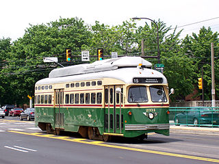
Route 15, the Girard Avenue Line, is a trolley line operated by the Southeastern Pennsylvania Transportation Authority (SEPTA) along Girard Avenue through North and West Philadelphia, Pennsylvania, United States. As of 2007, it is the only surface trolley line in the City Transit Division that is not part of the Subway–Surface Trolley Lines. SEPTA PCC II vehicles are used on the line.

West Kensington is a neighborhood in the North Philadelphia section of Philadelphia, Pennsylvania, United States. It is north of Olde Kensington. The Market Frankford El above Front Street forms the line between West Kensington and Kensington. Its bordering neighborhoods are Kensington to the east, Hartranft to the west, and Olde Kensington to the south. It is bounded by Front Street to the east, 6th Street to the west, Cecil B. Moore Avenue to the South and Lehigh Avenue to the north. It falls into the 19122 and 19133 ZIP Codes.
Kensington District, or The Kensington District of the Northern Liberties, was one of the twenty-nine municipalities that formed Philadelphia County, Pennsylvania, United States prior to the enactment of the Act of Consolidation, 1854, when it became incorporated into the newly expanded City of Philadelphia. The district was roughly bounded by Lehigh Avenue to the north; Germantown Avenue and 6th Street to the west; Cohocksink Creek to the south; and an L-shaped line formed by Frankford Avenue, Norris Street, and York Street at its northeast. The Delaware River was the eastern boundary. Today the area would include the Philadelphia neighborhoods of Olde Kensington, West Kensington and Fishtown, as well as portions of the neighborhoods of Ludlow, Hartranft, Fairhill, Northern Liberties and the current Kensington. The District of Kensington was a self-governing district between the years 1820 and 1854.

Route 10, also known as the Lancaster Avenue Line, is a trolley line operated by the Southeastern Pennsylvania Transportation Authority (SEPTA) that connects the 13th Street station in Center City Philadelphia, Pennsylvania, to the 63rd Street–Malvern Avenue station in the Overbrook section of West Philadelphia. It is one out of five lines that is part of the SEPTA's subway–surface trolley system and is 11.6 mi (18.7 km) long. It is the least used subway-surface trolley line, but unlike Route 11, the most used subway-surface trolley line, it has overnight service.
Girard station is an elevated rapid transit station which is located in Philadelphia, Pennsylvania, on SEPTA's Market–Frankford Line. It is situated at the corner of Front Street and Girard Avenue in the Fishtown neighborhood.

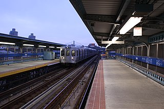
Berks station is an elevated rapid transit station on the SEPTA Market–Frankford Line, located at the corner of Front and Berks streets in the Kensington neighborhood of Philadelphia, Pennsylvania. The station is also served by SEPTA bus route 3.

York–Dauphin station is an elevated rapid transit station on the Market–Frankford Line, of the SEPTA transit system. It is located in the Kensington neighborhood of Philadelphia, Pennsylvania. The station is located at the intersection of Dauphin, Jasper, and Front Streets. it is the easternmost station running above Front Street; east of the station the line turns onto Kensington Avenue heading towards Frankford.

SEPTA Trolley Route 50 is a former streetcar line that was operated by the Southeastern Pennsylvania Transportation Authority (SEPTA) in Philadelphia, Pennsylvania, United States.

The River Wards is a section of Philadelphia, Pennsylvania, United States located along the Delaware River to the northeast of Center City Philadelphia. 'River Wards' is the commonly used name for an area including several neighborhoods, such as Fishtown, Kensington, Port Richmond and Olde Richmond. The River Wards are located at the border of North Philadelphia and Northeast Philadelphia, and may be considered part of one or the other, or as a separate entity. The area is sometimes also known as 'Kensington-Richmond'.

Girard Avenue is a major commercial and residential street in Philadelphia, Pennsylvania. For most of its length it runs east–west, but at Frankford Avenue it makes a 135-degree turn north. Parts of the road are signed as U.S. Route 13 and U.S. Route 30.
Olde Richmond is a neighborhood in the River Wards section of Philadelphia, Pennsylvania, United Sttes. It is notable for its historically large Polish immigrant, Polish American community, and Irish American community. The U.S. ZIP Code for Olde Richmond is 19125 and its post office is located at 1602 Frankford Avenue.
