Bensalem Township is a township in Bucks County, Pennsylvania, United States. The township borders the northeastern section of Philadelphia and includes the communities of Andalusia, Bensalem, Bridgewater, Cornwells Heights, Eddington, Flushing, Oakford, Siles, Trappe, and Trevose. Bensalem Township has no other incorporated municipalities within its boundaries.

Fishtown is a neighborhood in the River Wards section of Philadelphia, Pennsylvania, United States. Located northeast of Center City Philadelphia, its borders are somewhat disputed today due to many factors, but are roughly defined by the triangle created by the Delaware River, Frankford Avenue, and York Street. Some newer residents expand the area to Lehigh Avenue, while some older residents shrink the area to Norris Street. It is served by the Market–Frankford Line rapid transit subway/elevated line of the SEPTA system. Fishtown is a largely working class Irish Catholic neighborhood, but has recently seen a large influx of young urban professionals and gentrification.
Frankford is a neighborhood in the Northeast section of Philadelphia situated about six miles (10 km) northeast of Center City. Although its borders are vaguely defined, the neighborhood is bounded roughly by the original course of Frankford Creek on the south to Oakland Street on the northwest and southwest, to Bridge Street on the north, and to Aramingo Avenue and I-95 on the east. Adjacent neighborhoods are Bridesburg, Juniata, Northwood, Summerdale, and Wissinoming.
Holmesburg began as a Village within Lower Dublin Township, Pennsylvania. It is now a neighborhood in the Northeast section of Philadelphia, Pennsylvania. Holmesburg was named in Honor of Surveyor General of Pennsylvania Thomas Holme, who was a cartographer.

Mayfair is a working class neighborhood in lower Northeast Philadelphia, centered on the intersection of Cottman and Frankford Avenues. It is bordered by Tacony and Wissinoming to the south and east, Holmesburg to the east, Pennypack Park to the north, and Oxford Circle and Rhawnhurst to the west. Mayfair is historically home to a large Irish American population, but more recently has seen accelerated growth of Asian American population

Pennypack Creek is a 22.6-mile-long (36.4 km) creek in southeastern Pennsylvania in the United States. It runs southeast through lower Bucks County, eastern Montgomery County and the northeast section of Philadelphia, before emptying into the Delaware River.

Poquessing Creek is a 10.3-mile-long (16.6 km) creek, a right tributary of the Delaware River, that forms the boundary between Philadelphia and Bensalem Township, which borders it to the northeast along the Delaware. It has defined this boundary between Bucks and Philadelphia counties since 1682.

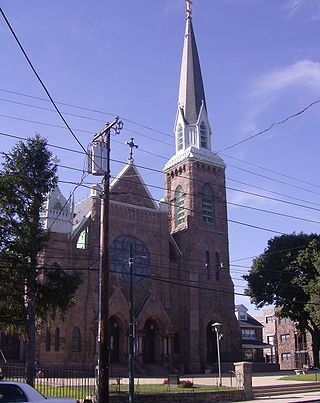
Bridesburg is the northernmost neighborhood in the River Wards section of Philadelphia, Pennsylvania, United States. Bridesburg is an historically German and Irish community, with a significant community of Polish immigrants who arrived mostly in the early- to mid-twentieth century. The community is home to two Catholic churches: All Saints Church, designed by Edwin Forrest Durang, built in 1889; and Saint John Cantius Church, built in 1898 in Polish Cathedral style.

Frankford Creek is a minor tributary of the Delaware River in southeast Pennsylvania. It derived its name from the nearby town of Frankford, Philadelphia County. The stream originates as Tookany Creek at Hill Crest in Cheltenham Township and meanders eastward, then southeastward, throughout Cheltenham Township, until a sharp bend near the Philadelphia border at Lawncrest, where the place names Toxony and Tookany were used in historic times; the stream is still known as Tookany Creek in this region, where it flows southwest. Turning south into Philadelphia at the crotch of Philadelphia's V-shaped border, the creek is called Tacony Creek; from here southward, it is considered the informal boundary separating Northeast Philadelphia from the rest of the city. The Philadelphia neighborhoods of Olney and Feltonville lie on the western side of the stream in this area while Northwood, Lawncrest, Summerdale, and Frankford lie on the eastern side. It continues to be called the Tacony at least until the smaller Wingohocking Creek merges with it in Juniata Park, within the city-owned golf course. Beyond Castor Avenue it is known as Frankford Creek until the stream's confluence with the Delaware River in the Bridesburg neighborhood of Philadelphia. The section of stream known as Frankford Creek is 3.1 miles (5.0 km) long, and the upstream section known as Tacony Creek, from Hill Crest, is 11.1 miles (17.9 km) long.
Morrell Park is a neighborhood located in the Northeast section of Philadelphia, Pennsylvania, United States. It is located on the eastern side of the Far Northeast, northwest of Byberry Creek and east of Northeast Philadelphia Airport.
Crestmont Farms is an affluent small residential neighborhood in the Northeast section of Philadelphia, Pennsylvania. It is located along the Bucks County line, at Poquessing Creek, east of Knights Road. The housing consists of single homes.
Andalusia is a historic neighborhood and unincorporated community in Bensalem Township, Pennsylvania, United States. It borders Philadelphia along the Poquessing Creek. It shares the Bensalem Township ZIP Code, 19020, with surrounding CDP's including Cornwells Heights. The area is the southernmost part of the township and of the county. Its boundaries are: Woodhaven Road to the northeast, the Delaware River to the east and south, and Poquessing Creek to the north and west. Interstate 95 - Delaware Expressway runs through its southeastern section near the Delaware River. The neighborhood takes its name from Andalusia, the estate of Philadelphia financier Nicholas Biddle (1786–1844), now preserved as a National Historic Landmark.
Lower Dublin Township, also known as Dublin Township, is a defunct township that was located in Philadelphia County, Pennsylvania, United States. The township ceased to exist and was incorporated into the City of Philadelphia following the passage of the Act of Consolidation, 1854.
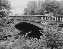
The Frankford Avenue Bridge, also known as the Pennypack Creek Bridge, the Pennypack Bridge, the Holmesburg Bridge, and the King's Highway Bridge, erected in 1697 in the Holmesburg section of Northeast Philadelphia, in the U.S. state of Pennsylvania, is the oldest surviving roadway bridge in the United States. The three-span, 73-foot-long (22 m) twin stone arch bridge carries Frankford Avenue, just north of Solly Avenue, over Pennypack Creek in Pennypack Park.
Wissinoming is a neighborhood in the Near Northeast section of Philadelphia. It was the site of locomotive builder Matthias Baldwin's estate "Wissinoming", which was located near Tacony and Van Kirk Streets. The current Wissinoming is bordered by Mayfair on the west and Tacony on the north, Bridesburg on the south, I-95 and the Delaware River on the east, and Frankford on the southwest. Wissinoming has two ZIP codes: 19124 and 19135. Physical boundaries are: Levick Street on the north, Bridge Street on the south, I-95 and the Delaware River on the east, and Frankford Avenue on the west.
Education in Philadelphia, Pennsylvania has a rich and storied history. This history began with Benjamin Franklin's founding of the University of Pennsylvania as European styled school and America's first university. Today's Philadelphia region is home to nearly 300,000 college students, numerous private and parochial secondary schools, and the 8th largest school district in the country.
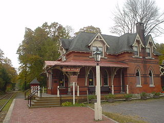
Glen Mills is an unincorporated community in Concord Township, Delaware County, Pennsylvania, United States, located approximately 27 miles west of Philadelphia. The ZIP code for Glen Mills is 19342.

Glen Foerd is a historic mansion and estate located in the Torresdale neighborhood of Philadelphia, Pennsylvania, overlooking the Delaware River near the mouth of Poquessing Creek.

Philadelphia Parks & Recreation (PPR) is the municipal department responsible for managing parks, recreation centers, playgrounds, trails, community gardens, and historic properties in Philadelphia, Pennsylvania. Its inventory includes more than 150 parks and 170 recreation centers and playgrounds. It became the successor to the Fairmount Park Commission and the City of Philadelphia Department of Recreation in 2010.