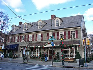
Chestnut Hill is a neighborhood in the Northwest Philadelphia section of the United States city of Philadelphia, Pennsylvania. It is known for the high incomes of its residents and high real estate values, as well as its private schools.

Rittenhouse Square is the name of both a public park and the surrounding neighborhood that is also referred to as Rittenhouse in Center City, Philadelphia, Pennsylvania, United States. The park is one of the five original open-space parks planned by William Penn and his surveyor Thomas Holme during the late 17th century.

Fox Chase is a neighborhood in Northeast Philadelphia, Pennsylvania.
Washington Square West is a neighborhood in downtown, or Center City, Philadelphia, Pennsylvania. The neighborhood roughly corresponds to the area between 7th and Broad Streets and between Chestnut and South Streets, bordering on the Independence Mall tourist area directly northeast, Market East to the north, Old City and Society Hill to the East, Bella Vista directly south, Hawthorne to the southwest, and mid-town Philadelphia and Rittenhouse Square to the west. In addition to being a desirable residential community, it is considered a hip, trendy neighborhood that offers a diverse array of shops, restaurants, and coffee houses. Washington Square West contains many gay-friendly establishments and hosts annual events celebrating LGBT culture in Philadelphia including OutFest. The area takes its name from Washington Square, a historic urban park in the northeastern corner of the neighborhood.

Manayunk is a neighborhood in the section of Lower Northwest Philadelphia in the state of Pennsylvania. Located adjacent to the neighborhoods of Roxborough and Wissahickon and also on the banks of the Schuylkill River, Manayunk contains the first canal begun in the United States. The area's name is derived from the language of the Lenape Indians. In 1686-dated papers between William Penn and the Lenape, the Lenape referred to the Schuylkill River as "Manaiung", their word for "river", which literally translates as "place to drink"; the word was later altered and adopted as the town's name.

Northern Liberties is a neighborhood in Philadelphia, Pennsylvania, United States. When a city, it was the 7th largest city in the United States in 1790.

Overbrook is a neighborhood northwest of West Philadelphia, Philadelphia, in the U.S. state of Pennsylvania. The area's housing ranges from large, old homes to rowhouses to 3- and 4-story apartment buildings.
Holmesburg began as a Village within Lower Dublin Township, Pennsylvania. It is now a neighborhood in the Northeast section of Philadelphia, Pennsylvania. Holmesburg was named in Honor of Surveyor General of Pennsylvania Thomas Holme, who was a cartographer.

Kensington is a neighborhood in Philadelphia, Pennsylvania, United States, which straddles Lower Northeast and North Philadelphia. It is part of the River Wards. Modern Kensington is larger than the former Kensington District, and unlike the latter, the former does not include Fishtown.

East Falls is a neighborhood in the Northwest section of Philadelphia, Pennsylvania, United States. It lies on the east bank of the "Falls of the Schuylkill," cataracts submerged in 1822 by the Schuylkill Canal and Fairmount Water Works projects. East Falls sits next to the Germantown, Roxborough, Allegheny West, and Nicetown-Tioga neighborhoods, and to Wissahickon Valley Park. The neighborhood runs along a few miles of Ridge Avenue, along the banks of the Schuylkill River then extends northeast to Wissahickon Avenue. It overlooks the multi-use recreational path of Fairmount Park along Kelly Drive, and is desirable for its central location, an easy commute to Center City with easy access to several major roadways and public transportation.
Cobbs Creek is a neighborhood located in the West Philadelphia section of Philadelphia, Pennsylvania, United States, named for the creek which forms part of Philadelphia's western border. Cobbs Creek is generally bounded by Market Street to the north, Baltimore Avenue to the south, 52nd Street to the east, and the border of Upper Darby along Cobbs Creek to the West.
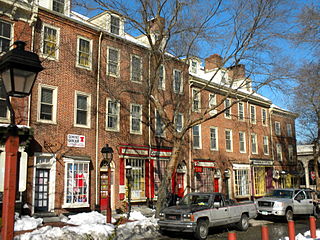
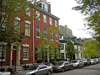
Society Hill is a historic neighborhood in Center City Philadelphia, Pennsylvania with a population of 6,215 as of the 2010 United States Census. Settled in the early 1680s, Society Hill is one of the oldest residential neighborhoods in Philadelphia. After urban decay developed between the late 19th and early 20th centuries, an urban renewal program began in the 1950s, restoring the area and its many historic buildings. Society Hill has since become one of the most expensive neighborhoods with the highest average income and second highest real estate values in Philadelphia. Society Hill's historic colonial architecture, along with planning and restoration efforts, led the American Planning Association to designate it, in 2008, as one of the great American neighborhoods and a good example of sustainable urban living.

Grays Ferry, also known as Gray's Ferry, is a neighborhood in South Philadelphia bounded (roughly) by 25th Street on the east, the Schuylkill River on the west, Vare Avenue on the south, and Grays Ferry Avenue on the north. The section of this neighborhood west of 34th Street is also known as Forgotten Bottom. Grays Ferry shares borders with Southwest Center City to the North, Point Breeze to the East, and Girard Estate to the South. Gray’s Ferry is across from where Mill Creek debouches at about 43rd street. Historically, Grays Ferry was one of the largest enclaves of Irish Americans in the city, and while there are still many Irish left, it is now home to a significant African American population.

The Institute of Pennsylvania Hospital, also known as Kirkbride's Hospital or the Pennsylvania Hospital for Mental and Nervous Diseases, was a psychiatric hospital located at 48th and Haverford Streets in Philadelphia, Pennsylvania, USA. It operated from its founding in 1841 until 1997. The remaining building, now called the Kirkbride Center is now part of the Blackwell Human Services Campus.

Parkwood is a neighborhood located in the Far Northeast section of Philadelphia, Pennsylvania, United States. The neighborhood's boundaries include the Byberry East Industrial Park to the north and northwest, Poquessing Creek to the east, Knights Road to the southeast and Woodhaven Road to the southwest. The neighborhood was developed by Hyman Korman in the 1960-62 as a planned residential community. The predominant housing type is the brick row house. The Parkwood Shopping Center is a local shopping destination, while the Philadelphia Mills mall is a regional shopping destination on Knights Road to the east of Parkwood's residential area.
Oscar Gregory Stonorov was a modernist architect and architectural writer, historian and archivist who emigrated to the United States from Germany in 1929. His first name is often spelled "Oskar".
Greenbelt Knoll is a residential development in the Northeast section of Philadelphia, Pennsylvania. Planned and built from 1952 to 1957, it is notable as the first planned racially integrated development in Philadelphia and among the first in the United States.
Bache-Martin Elementary School is a preK–8 school located in the Fairmount neighborhood of Philadelphia, Pennsylvania. It is part of the School District of Philadelphia. The school campus comprises two distinct buildings along 22nd Street, both of which were listed on the National Register of Historic Places in 1986.

Parkway West High School is a public magnet high school located in the Mill Creek neighborhood of Philadelphia, Pennsylvania. It shares a site with the Middle Years Alternative School for the Humanities (MYA). Both schools are part of the School District of Philadelphia.

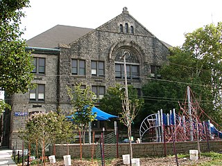
Rudolph Blankenburg School is a historic school located in the Mill Creek neighborhood of Philadelphia, Pennsylvania. It is part of the School District of Philadelphia. It is named in honor of Rudolph Blankenburg, who was mayor of Philadelphia between 1911 and 1915. The building was designed by Irwin T. Catharine and built in 1923–1925. It is a three-story, nine bay by five bay, brick building on a raised basement in the Colonial Revival style. It features large stone arch surrounds on the first level, a projecting entrance pavilion, a double stone cornice, and brick parapet topped by stone coping.

