Kingsessing is a neighborhood in the Southwest section of Philadelphia, Pennsylvania, United States. On the west side of the Schuylkill River, it is next to the neighborhoods of Cedar Park, Southwest Schuylkill, and Mount Moriah, as well as the borough of Yeadon in Delaware County. It is roughly bounded by 53rd Street to the northeast, Baltimore Avenue to the northwest, Cobbs Creek and 60th Street to the southwest, and Woodland Avenue to the southeast.

Brewerytown is a neighborhood in the North Philadelphia section of Philadelphia, Pennsylvania, United States. An unofficial region, Brewerytown runs approximately between the Schuylkill River's eastern bank and 25th Street, bounded by Montgomery Avenue to the north and Parrish Street to the south. Brewerytown derived its name from the numerous breweries that were located along the Schuylkill during the late 19th century and early 20th century. It is now primarily a residential neighborhood, with a growing and active commercial sector along Girard Avenue.
Cobbs Creek is a neighborhood located in the West Philadelphia section of Philadelphia, Pennsylvania, United States, named for the creek which forms part of Philadelphia's western border. Cobbs Creek is generally bounded by Market Street to the north, Baltimore Avenue to the south, 52nd Street to the east, and the border of Upper Darby along Cobbs Creek to the West.

This is a list of properties and districts listed on the National Register of Historic Places in Pennsylvania. As of 2015, there are over 3,000 listed sites in Pennsylvania. All 67 counties in Pennsylvania have listings on the National Register.

Southwark was originally the Southwark District, a colonial-era municipality in Philadelphia County, Pennsylvania, United States. Today, it is a neighborhood in the South Philadelphia section of Philadelphia, Pennsylvania. Because of its location south of the early Philadelphia, the name was adopted in allusion to the borough of Southwark in the county of London, England, just south of the city of London.
Girard Estate, also known as Girard Estates, is part of South Philadelphia, Pennsylvania, United States. Its boundaries stretch from South 22nd Street on the west to South 17th Street on the east. The southern boundary is clearly defined as the south side of Shunk Street, but its northern boundary is irregular in stretching from the north side of Porter Street between South 17th Street and South 21st Streets, along the east side of South 21st Street to West Passyunk Avenue, then along the south side of West Passyunk Avenue to its northwestern tip at South 22nd Street. It is named after Stephen Girard, whose South Philadelphia property was developed in the 1920s by the City of Philadelphia.

Overbrook Farms is a neighborhood that is situated on the western edge of the West Philadelphia section of Philadelphia, Pennsylvania, United States. It is roughly bounded by City Avenue, 58th Street, Woodbine Avenue, and 66th Street at Morris Park.

The Woodlands is a National Historic Landmark District on the west bank of the Schuylkill River in Philadelphia. It includes a Federal-style mansion, a matching carriage house and stable, and a garden landscape that in 1840 was transformed into a Victorian rural cemetery with an arboretum of over 1,000 trees. More than 30,000 people are buried at the cemetery. Among the tombstones at Woodlands cemetery is the tombstone of Dr Thomas W. Evans, which at 150 feet, is both the tallest gravestone in the United States and the tallest obelisk gravestone in the world.

Haddington is a neighborhood in the West Philadelphia section of Philadelphia, Pennsylvania, United States. Its borders are defined as Haverford Avenue/Girard Avenue to the north, 52nd Street to the east, Market Street to the south, and 67th Street to the westernmost edge of the neighborhood.
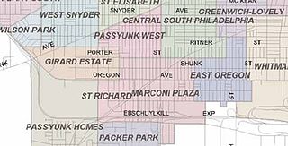
Marconi Plaza is an urban park square located in South Philadelphia, Philadelphia, Pennsylvania, United States. The plaza was named to recognize the 20th-century cultural identity in Philadelphia of the surrounding Italian-American enclave neighborhood and became the designation location of the annual Columbus Day Parade.

Samuel Sloan was a Philadelphia-based architect and best-selling author of architecture books in the mid-19th century. He specialized in Italianate villas and country houses, churches, and institutional buildings. His most famous building—the octagonal mansion "Longwood" in Natchez, Mississippi—is unfinished; construction was abandoned during the American Civil War.

Wilson Eyre, Jr. was an American architect, teacher and writer who practiced in the Philadelphia area. He is known for his deliberately informal and welcoming country houses, and for being an innovator in the Shingle Style.

The West Philadelphia Streetcar Suburb Historic District is an area of West Philadelphia listed on the National Register of Historic Places. It represented the transformation of Philadelphia's rural farmland into urban residential development, made possible by the streetcar, which provided easy access to Center City. This is an early example of the streetcar suburb.

The Centennial National Bank is a historic building in Philadelphia, Pennsylvania. Designed by noted Philadelphia architect Frank Furness and significant in his artistic development, it was built in 1876 as the headquarters of the eponymous bank that would be the fiscal agent of the Centennial Exposition. The building housed a branch of the First Pennsylvania Bank from 1956 until Drexel University purchased it c. 1976. Drexel renovated it between 2000-2002 and now uses it as an alumni center. The Centennial National Bank, described as "one of the best pieces of architecture in West Philadelphia," was placed on the National Register of Historic Places in 1971.

Wissahickon is a neighborhood in the section of Lower Northwest Philadelphia in the state of Pennsylvania, United States. Wissahickon is located adjacent to the neighborhoods of Roxborough and Manayunk, and it is bounded by the Wissahickon Valley Park, Ridge Avenue, Hermit Street, and Henry Avenue. The name of the neighborhood is derived from the Lenni Lenape word wisameckham, for "catfish creek", a reference to the fish that were once plentiful in the Wissahickon Creek.
Paul Amos Batholomew (1883–1973) was an architect in Greensburg, Pennsylvania. From the beginning of his practice, he received a variety of high-profile commissions for both residential and non-residential structures, mainly in Westmoreland County, Pennsylvania. His buildings typically had historicist facades, with neoclassical or Italianate ornamentation covering a modern framework. It was only in the 1950s, toward the end of his career, that he created buildings that were purely modern in design. During the Great Depression, a particularly trying time for architects, he received the commission to design Norvelt, which was a new town created as part of President Roosevelt's New Deal policies.

Willis Gaylord Hale was a late-19th century architect who worked primarily in Philadelphia, Pennsylvania. His flamboyant, highly-ornate style was popular in the 1880s and 1890s, but quickly fell out of fashion at the dawn of the 20th century.

Stephen Decatur Button was an American architect and a pioneer in the use of metal-frame construction for masonry buildings. He designed commercial buildings, schools and churches in Philadelphia, Pennsylvania, and Camden, New Jersey; and more than 30 buildings in Cape May, New Jersey.

Edmund Beaman Gilchrist was an American architect, best remembered for his English-Cotswold and French-Norman suburban houses.

Girard Avenue is a major commercial and residential street in Philadelphia, Pennsylvania. For most of its length it runs east–west, but at Frankford Avenue it makes a 135-degree turn north. Parts of the road are signed as U.S. Route 13 and U.S. Route 30.


