30th Street Station District

Last updated
30th Street Station District
Cira Centre, Philadelphia-east-2.JPG
Cira Centre is located in the 30th Street Station District
Location West Philadelphia, Pennsylvania, United States (Philadelphia)
StatusUnder construction
Groundbreaking2017
Estimated completion2046
Website 30th Street Station District
Companies
Architect Skidmore, Owings & Merrill
Developer Brandywine Realty Trust
Owner Amtrak and City of Philadelphia
Technical details
Cost $6.5 Billion
Buildings
2901 Arch Street - 1,200 ft (365m)
  • 3001 JFK Blvd - 705 ft (214m)
  • 2928 Race Street - 670 ft (204m)
  • 3100 Cherry Street - 605 ft (184m)
  • 2929 Race Street - 590 ft (180m)
  • 3000 Baring Street - 570 ft (174m)
  • 3100 Winter Street - 435 ft (132m)
  • 3120 Race Street - 405 ft (123m)
Size7,623,000 sq. feet

The 30th Street Station District, also referred to as the 30th Street District, is a master planned urban development centered around 30th Street Station located in West Philadelphia in Philadelphia, Pennsylvania, United States. The area, if approved and built, will be home to eight modern skyscrapers or high rises ranging in heights between 405 ft and1,200 ft with four other buildings under 400 feet. The property will be owned by Amtrak and will be a major addition to the City of Philadelphia. The project is expected to cost between seven and eleven billion dollars. [1]

Contents

The project would be a huge addition to the city with some of the largest buildings not in Center City and expanding downtown west of the Schuylkill River. [2]

Aside from adding new buildings to the skyline, architects have put in their plans to connect West Philadelphia to Center City by adding new walking paths, a walking bridge, and more connections to make traveling by car or bus from the 30th Street Station to downtown Philadelphia easier and faster. In addition, the placement of the current phase of construction would allow expansion north towards the Philadelphia Museum of Art and the Philadelphia Zoo.

Project history

The 30th Street Station District Plan is a long-range, joint master planning effort led by Amtrak, Brandywine Realty Trust, Drexel University, the Pennsylvania Department of Transportation, and the Southeastern Pennsylvania Transportation Authority to develop a comprehensive vision for the future of the 30th Street Station District in the year 2050 and beyond. [3]

A $2 billion investment in roads, utilities, parks, bridges, and extension of transit services will unlock $4.5 billion in private real estate investment, in addition to an estimated $3.5 billion for Drexel’s Schuylkill Yards project, which is located within the district. These investments in the District will have robust and widespread economic development benefits, with the potential to generate $3.8 billion in City and State taxes and 40,000 jobs when complete. [4]

The project launched in the summer of 2014, and had its first public meeting by that winter. The project had four additional public meetings in summer of 2015, the fall of 2015, and two in the spring of 2016. The planning process was officially completed in June 2016, and is set to be undertaken in various phases. [5]

As of January 2024, there are currently three projects undergoing. The renovation of 30th Street Station began in 2023, and will conclude in 2027. These renovations including building maintenance such as façade cleaning and restoration, improvements of Market Street Plaza, expanded retail offerings, station modernization, corporate office renovation, etc. [6] There is a project underway to improve the SEPTA 30th Street subway and trolley station, including new elevators at 31st Street and a new head house at 30th Street, of which the former is complete. [7] Additionally, a ramp modification study is underway for I-76. [7]

Plan

The District Plan lays out a vision for the next 35 years and beyond to:

Reconnecting the station

Passenger volume at 30th Street Station is projected to more than double over the next 25 years and beyond. Travel to the District is easily achieved by a number of modes, with nearly 100,000 trips made daily by train, subway, bus, trolley, car, bicycle, or on foot. However, the modes do not clearly connect, creating a confusing and sometimes precarious experience for visitors.

For almost 30 years, passengers transferring between 30th Street Station and the trolley and subway lines below Market Street have lacked a covered, climate-controlled route, forced instead to leave the station and cross a busy 30th Street. The Plan proposes to re-establish a convenient and safe connection between these stations, via a new stairway within 30th Street Station’s Main Hall and through an active and day-lit below-grade retail concourse.

The Plan also envisions a permanent home for intercity buses (BoltBus, Megabus, and others) on the north side of Arch Street as part of an integrated, multimodal transportation facility. The new intercity bus terminal connects directly via pedestrian bridge to 30th Street Station and provides an indoor waiting area along with bus queuing. In the long-term, an additional Amtrak concourse could anchor this new transit center. [8]

Funding and Cost

Amtrak and its partners in the proposed redevelopment of a massive swath around 30th Street Station in University City say the decades-long plan, including partially capping the adjacent rail yard, will involve $6.5 billion in infrastructure funding and private investment. The financial projection is part of the planning team's final blueprint for the 175-acre site extending northeast from 30th Street Station. [9]

Publication of the 30th Street Station District Plan ends a two-year, $5.25 million study led by Amtrak, Drexel University, Brandywine Realty Trust, SEPTA, and PennDot for the area between Walnut and Spring Garden Streets east of Drexel's campus and Powelton Village.

Buildings

The 35-year plan to build a dense urban neighborhood, largely over what are now 88 acres of rail yards, will require about $2 billion in infrastructure investment, according to a plan summary. That spending on roads, bridges, parks, and transit would enable about $4.5 billion in private investment by developers of office towers, residential buildings, hotels, and other projects.

Anticipated is about 18 million square feet of new development, including enough housing to accommodate up to 10,000 residents. The commercial space includes about 1.2 million square feet planners hope will be occupied by a single corporate, commercial, or institutional tenant that will anchor the development, though none has yet been secured. [10]

Project partners

As of January 2024 the following are partners [11] of the project:

Awards

AwardDate awardedRef
2017 American Institute of Architects AwardJanuary 13, 2017 [12]

See also

Related Research Articles

<span class="mw-page-title-main">SEPTA</span> Public transportation authority

The Southeastern Pennsylvania Transportation Authority (SEPTA) is a regional public transportation authority that operates bus, rapid transit, commuter rail, light rail, and electric trolleybus services for nearly four million people in five counties in and around Philadelphia, Pennsylvania. It also manages projects that maintain, replace and expand its infrastructure, facilities and vehicles.

<span class="mw-page-title-main">Market–Frankford Line</span> SEPTA rapid transit line in Philadelphia, Pennsylvania

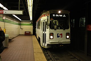
The Market–Frankford Line (MFL), or the Blue Line) is one of three rapid transit lines in Philadelphia, Pennsylvania; it and the Broad Street Line are operated by SEPTA, and the PATCO Speedline is operated by PATCO. The Market–Frankford Line runs from the 69th Street Transportation Center in Upper Darby, just outside of West Philadelphia, through Center City Philadelphia to the Frankford Transportation Center in Near Northeast Philadelphia. From 2024 onwards, this line will be rebranded as the L line.

<span class="mw-page-title-main">SEPTA Regional Rail</span> Commuter rail service in Philadelphia, Pennsylvania, US

The SEPTA Regional Rail system is a commuter rail network owned by SEPTA and serving the Philadelphia metropolitan area. The system has 13 branches and more than 150 active stations in Philadelphia, Pennsylvania, its suburbs and satellite towns and cities. It is the sixth-busiest commuter railroad in the United States, and the busiest outside of the New York, Chicago, and Boston metropolitan areas. In 2016, the Regional Rail system had an average of 132,000 daily riders and 118,800 daily riders as of 2019.

<span class="mw-page-title-main">Transportation in Philadelphia</span>

Transportation in Philadelphia involves the various modes of transport within the city and its required infrastructure. In addition to facilitating intracity travel, Philadelphia's transportation system connects Philadelphia to towns of its metropolitan area and surrounding areas within the Northeast megalopolis.

<span class="mw-page-title-main">University City, Philadelphia</span> Neighborhood of Philadelphia in Philadelphia County, Pennsylvania, United States

University City is the easternmost portion of West Philadelphia, encompassing several Philadelphia universities. It is situated directly across the Schuylkill River from Center City.

<span class="mw-page-title-main">SEPTA Routes 101 and 102</span> Light rail lines in Delaware County, Pennsylvania

SEPTA Routes 101 and 102, From 2024, D1 & D2, also known as the Media–Sharon Hill Line, are light rail lines operated by the Suburban Transit Division of the Southeastern Pennsylvania Transportation Authority, serving portions of Delaware County. The routes' eastern terminus is 69th Street Transportation Center in Upper Darby Township, Pennsylvania. Route 101 runs to Media, while Route 102 goes to Sharon Hill. Altogether, the two lines operate on approximately 11.9 miles (19.2 km) of route. The lines were formerly interurbans.

<span class="mw-page-title-main">West Philadelphia</span> Neighborhood of Philadelphia, Pennsylvania

West Philadelphia, nicknamed West Philly, is a section of the city of Philadelphia. Although there are no officially defined boundaries, it is generally considered to reach from the western shore of the Schuylkill River, to City Avenue to the northwest, Cobbs Creek to the southwest, and the SEPTA Media/Wawa Line to the south. An alternate definition includes all city land west of the Schuylkill; this would also include Southwest Philadelphia and its neighborhoods. The eastern side of West Philadelphia is also known as University City.

<span class="mw-page-title-main">SEPTA subway–surface trolley lines</span> Philadelphia trolley lines

The SEPTA subway–surface trolley lines are a collection of five SEPTA trolley lines that operate on street-level tracks in West Philadelphia and Delaware County, Pennsylvania, and also underneath Market Street in Philadelphia's Center City. The lines, Routes 10, 11, 13, 34, and 36, collectively operate on about 39.6 miles (63.7 km) of route.

Schuylkill River Passenger Rail is a proposed passenger train service along the Schuylkill River between Philadelphia and Reading, Pennsylvania, with intermediate stops in Norristown, King of Prussia, Phoenixville, and Pottstown.

<span class="mw-page-title-main">SEPTA Route 15</span> SEPTA trolley line in Philadelphia, Pennsylvania

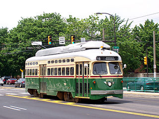
Route 15, the Girard Avenue Line, is a trolley line operated by the Southeastern Pennsylvania Transportation Authority (SEPTA) along Girard Avenue through North and West Philadelphia, Pennsylvania, United States. As of 2007, it is the only surface trolley line in the City Transit Division that is not part of the Subway–Surface Trolley Lines. SEPTA PCC II vehicles are used on the line.

<span class="mw-page-title-main">Cira Centre</span> Office high-rise in Philadelphia, Pennsylvania

The Cira Centre is a 29-story, 437-foot (133 m) office high-rise in the University City section of Philadelphia, directly connected to Amtrak's 30th Street Station. Developed by Brandywine Realty Trust and designed by César Pelli, it was built in 2004-05 on a platform over rail tracks.

<span class="mw-page-title-main">22nd Street station (SEPTA)</span> Underground trolley station in Philadelphia, Pennsylvania

22nd Street station is an underground trolley station in Center City, Philadelphia that serves the SEPTA Subway–Surface Trolley Lines. Similar to 19th Street station, three blocks east of it, the station has two side platforms and a total of four tracks. The station serves only subway–surface trolleys on the two outer tracks; the Market-Frankford Line subway uses the two inner tracks and bypasses the station as it travels between 15th Street and 30th Street station.

<span class="mw-page-title-main">Pennsylvania Route 3</span> State highway in Chester, Delaware, and Philadelphia counties in Pennsylvania, US

Pennsylvania Route 3 is a 24.3-mile (39.1 km) state highway located in the southeastern portion of Pennsylvania. The route runs from U.S. Route 322 Business in West Chester east to PA 611 in Philadelphia.

<span class="mw-page-title-main">Drexel Station at 30th Street</span> Rapid transit station in Philadelphia

Drexel Station at 30th Street is an underground SEPTA Metro station in Philadelphia. It is located on Market Street between 30th and 31st Streets in the University City neighborhood, adjacent to 30th Street Station and Drexel University. The station features four tracks – the inner pair serving the L and the outer pair for the T.

<span class="mw-page-title-main">SEPTA Suburban Division bus routes</span>

The Southeastern Pennsylvania Transportation Authority operates or contracts operations of these routes serving points in Bucks, Chester, Delaware, and Montgomery counties, with a few routes operating into the city of Philadelphia. The Suburban Transit Division is broken down into three districts: Victory, Frontier, and Contract Operations.

Callowhill Depot is a bus and trolley barn operated by the Southeastern Pennsylvania Transportation Authority (SEPTA), located in West Philadelphia, near the Delaware County border. It was built in 1913 by the Philadelphia Rapid Transit Company (PRT) and was later operated by the Philadelphia Transportation Company (PTC) before being taken over by SEPTA. The depot was constructed as part of the Thomas E. Mitten modernization program. Since its construction, the depot has suffered fire damage and reconstruction in 1949, 1950, and 1995.

<span class="mw-page-title-main">Cynwyd Line</span> SEPTA Regional Rail line

The Cynwyd Line is a SEPTA Regional Rail line from Center City Philadelphia to Cynwyd in Montgomery County, Pennsylvania. Originally known as the Ivy Ridge Line, service was truncated on May 17, 1986, at its current terminus at Cynwyd.

<span class="mw-page-title-main">Manayunk/Norristown Line</span> SEPTA Regional Rail line

The Manayunk/Norristown Line is a commuter rail service in Southeastern Pennsylvania between Center City Philadelphia and Norristown, and one of the 13 lines in SEPTA's Regional Rail network. It has the second highest operating ratio (19.9%) on the SEPTA Regional Rail network.

<span class="mw-page-title-main">30th Street Station</span> Railway station in Philadelphia, Pennsylvania

30th Street Station, officially William H. Gray III 30th Street Station, is a major intermodal transit station in Philadelphia, Pennsylvania, United States. It is metropolitan Philadelphia's main railroad station and a major stop on Amtrak's Northeast and Keystone corridors.

<span class="mw-page-title-main">Schuylkill Yards</span>

Schuylkill Yards is a $3.5 billion, masterplanned development project by Brandywine Realty Trust in West Philadelphia. The project was announced in a press conference in March 2016. The project is being designed in phases. Groundbreaking occurred in late 2017, and the first piece—a public park called Drexel Square—was delivered in June 2019.

References

  1. "30th Street Station District Plan". Som.com. Retrieved 15 November 2017.
  2. "30th Street Station District - Plan for Philadelphia". Phillymag.com. 16 June 2016. Retrieved 11 August 2016.
  3. "Philly District 30". Phillydistrict30.com. PENNDOT, Philadelphia Downtown, Brindywine Trust and Reality, Philadelphia Transportation and Emtrak. Retrieved August 19, 2016.
  4. "30th Street Station District Plan" (PDF). Static1.squarespace.com. Retrieved 15 November 2017.
  5. "Process + Timeline". Philadelphia 30th Street Station District Plan. 2020-06-25. Retrieved 2024-01-23.
  6. "William H. Gray III 30th Street Station Redevelopment". William H. Gray III 30th Street Station Redevelopment. Retrieved 2024-01-23.
  7. 1 2 "Current Projects". Philadelphia 30th Street Station District Plan. 2020-06-25. Retrieved 2024-01-23.
  8. "ABCD" (PDF). Static1.squarespace.com. Retrieved 15 November 2017.
  9. 30th Street Station District Planning, Funding and cost details. p. 181 in "30th Street Station" Funding PDF - Retrieved August 12, 2016
  10. "Funding for 30th Station District". Articles.philly.com. Retrieved 2016-08-11.
  11. "Project Partners". Philadelphia 30th Street Station District Plan. Retrieved 23 January 2024.
  12. "Philadelphia 30th Street Station District Plan wins 2017 AIA award". Masstransitmag.com. 14 January 2017. Retrieved 30 January 2017.