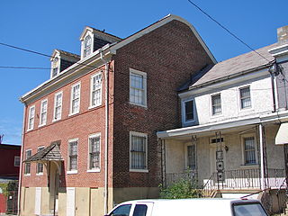
History
Historical population| Census | Pop. | Note | %± |
|---|
| 1820 | 7,118 | | — |
|---|
| 1830 | 13,394 | | 88.2% |
|---|
| 1840 | 22,314 | | 66.6% |
|---|
| 1850 | 46,774 | | 109.6% |
|---|
Captain Anthony Palmer originally laid out Kensington as a town in the 1730s. Palmer, an English merchant by way of Barbados, had come to colonial Pennsylvania about 1704, investing in land while continuing his mercantile business interests. He eventually turned to politics and was invited to join the Pennsylvania Council, which he did by 1710. When the local innkeeper Worthington put up the old Fairman Mansion for sale in 1729, Palmer purchased the mansion house and the surrounding 191½ acres and began laying out his town of Kensington, selling lots to a number of shipbuilders in nearby Philadelphia, who were looking to expand or enlarge their businesses. The town of Kensington started around shipbuilding and Shad fishing industries. (Fishtown was a small section of the original District of Kensington). Kensington was named for the monarch's residence in England, Kensington Palace. The early street names of Kensington also bore this out as they mimicked the titles of the crown; King Street (now Beach), Queen Street (now Richmond), Prince Street (now Girard Avenue) and Duke Street (now Thompson), etc. Due to his political longevity, Palmer eventually became the acting Governor of Pennsylvania in 1748-49, due to the absence of the governor who went back to England for health reasons. According to the research of Ken Milano, it was during Palmer's brief reign as acting governor that Kensington, for one day, was the working capital of the colony" the Council met there because Palmer, being old and infirm, was not able to travel into Philadelphia.
By 1820, Kensington started to acquire men of wealth, who petitioned the state to become a self-governing district within Philadelphia County, as at the time it was a part of the Northern Liberties Township. It was granted self-rule, and incorporated on March 6, 1820. For 34 years, Kensington was a self-governing district within the County of Philadelphia. In 1854, Kensington joined with the other towns, boroughs, and districts of Philadelphia County and consolidated with the City of Philadelphia. This was said to have been necessary due to utility and policing reasons (Kensington had been the scene of the start of the Anti-Irish Catholic Riots that occurred in Philadelphia County in May & July 1844).
Over the years the town of Kensington became quite successful and quite well known as the heart of Philadelphia's industrial heyday. When Philadelphians referred to things being "Made in Philadelphia", most of what they referred to was manufactured in Kensington. There was another saying that "If you can't get it at K & A (Kensington & Allegheny Avenues) you can't get." Kensington was the place where a number of notable industries were founded such as William Cramp Shipyard, John B. Stetson Hat Company, Schoenhut Toy Factory, Bromley Mills, and Disston’s Keystone Saw Works, amongst numerous other businesses. Before the Great Depression of the 1930s, Kensington at one time had 35,000 textile jobs alone.

Fishtown is a neighborhood in the River Wards section of Philadelphia, Pennsylvania, United States. Located northeast of Center City Philadelphia, its borders are somewhat disputed today due to many factors, but are roughly defined by the triangle created by the Delaware River, Frankford Avenue, and York Street. Some newer residents expand the area to Lehigh Avenue, while some older residents shrink the area to Norris Street. It is served by the Market–Frankford Line rapid transit subway/elevated line of the SEPTA system. Fishtown is a largely working class Irish Catholic neighborhood, but has recently seen a large influx of young urban professionals and gentrification.

Northern Liberties is a neighborhood in Philadelphia, Pennsylvania, United States. Prior to its incorporation into Philadelphia in 1854, it was among the top 10 largest cities in the U.S. in every census from 1790 to 1850.
Frankford is a neighborhood in the Northeast section of Philadelphia situated about six miles (10 km) northeast of Center City. Although its borders are vaguely defined, the neighborhood is bounded roughly by the original course of Frankford Creek on the south to Castor Avenue on the northwest and southwest, to Cheltenham Avenue on the north, and to Aramingo Avenue and I-95 on the east. [source: GoogleMaps] Adjacent neighborhoods are Bridesburg, Juniata, Northwood, Summerdale, and Wissinoming.

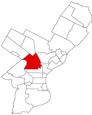
Kensington, colloquially known locally as Kenzo, is a neighborhood in Philadelphia that belongs to or divides Lower Northeast and North Philadelphia. As with all neighborhoods in the city, the lack of any official designation means the boundaries of the area vary between sources over time and are disputed among locals. Kensington, as most long-term residents view it, refers generally to the area consisting of Kensington, East, or Lower Kensington, West Kensington, and Harrowgate. The adjacent Fairhill and Norris Square neighborhoods are more separate but may be included in Kensington; Fishtown and South (Olde) Kensington were historically included. The most conservative boundaries of the neighborhood, shown in the map below, are Front Street and 5th Street to the west, the Amtrak train tracks to the North, Trenton Avenue, the Trenton Avenue train tracks, and Frankford Avenue to the east, and Cecil B. Moore Avenue to the south.

North Philadelphia, nicknamed North Philly, is a section of Philadelphia, Pennsylvania. It is immediately north of Center City. Though the full extent of the region is somewhat vague, "North Philadelphia" is regarded as everything north of either Vine Street or Spring Garden Street, between Northwest Philadelphia and Northeast Philadelphia. It is bordered to the north by Cheltenham Township along Cheltenham Avenue, Spring Garden Street to the south, 35th Street to the west and Adams Avenue to the east. The Philadelphia Police Department patrols five districts located within North Philadelphia: the 22nd, 25th, 26th, 35th and 39th districts. There are fifteen ZIP codes for North Philadelphia: 19120, 19121, 19122, 19123, 19125, 19126, 19130, 19132, 19133, 19134, 19137, 19138, 19140, 19141, and 19150.
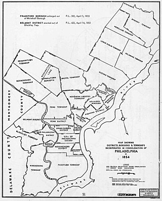
The Act of Consolidation, more formally known as the act of February 2, 1854, is legislation of the Pennsylvania General Assembly that created the consolidated City and County of Philadelphia, expanding the city's territory to the entirety of Philadelphia County and dissolving the other municipal authorities in the county. The law was enacted by the General Assembly and approved February 2, 1854, by Governor William Bigler. This act consolidated all remaining townships, districts, and boroughs within the County of Philadelphia, dissolving their governmental structures and bringing all municipal authority within the county under the auspices of the Philadelphia government. Additionally, any unincorporated areas were included in the consolidation. The consolidation was drafted to help combat lawlessness that the many local governments could not handle separately and to bring in much-needed tax revenue for the State.

Southwark was originally the Southwark District, a colonial-era municipality in Philadelphia County, Pennsylvania, United States. Today, it is a neighborhood in the South Philadelphia section of Philadelphia, Pennsylvania. Because of its location south of the early Philadelphia, the name was adopted in allusion to the borough of Southwark in the county of London, England, just south of the city of London.
Olde Kensington, also known as South Kensington, is a neighborhood located in North Philadelphia section of Philadelphia, Pennsylvania, United States. South Kensington is north of Northern Liberties, south of Norris Square, east of Ludlow, and west of Fishtown. The boundaries of the neighborhood are Berks St. (north), Girard Ave (south), Front St (east) and 6th St. (west).
Northern Liberties Township is a defunct township that was located in Philadelphia County, Pennsylvania, United States. The township ceased to exist and was incorporated into the City of Philadelphia after the passage of the Act of Consolidation, 1854.
Aramingo Borough is a defunct borough that was located in Philadelphia County, Pennsylvania, United States. The borough ceased to exist and was incorporated into the City of Philadelphia following the passage of the Act of Consolidation, 1854.
Belmont District is a defunct district that existed briefly in Philadelphia County, Pennsylvania, United States. The district was created on April 14, 1853 from northern Blockley Township ceased to exist and on February 2, 1854 the district was incorporated into the City of Philadelphia following the passage of the Act of Consolidation, 1854.

Penn District is a defunct district that was located in Philadelphia County, Pennsylvania, United States. The district ceased to exist and was incorporated into the City of Philadelphia following the passage of the Act of Consolidation, 1854.
Penn Township is a defunct township that was located in Philadelphia County, Pennsylvania, United States. The township ceased to exist and was incorporated into the City of Philadelphia following the passage of the Act of Consolidation, 1854.

Richmond District, also known as Port Richmond District, is a defunct district that was located in Philadelphia County, Pennsylvania, United States. The district ceased to exist and was incorporated into the City of Philadelphia following the passage of the Act of Consolidation, 1854.
Whitehall Borough is a defunct borough that was located in Philadelphia County, Pennsylvania, United States. The borough ceased to exist when it was incorporated into the City of Philadelphia on the passage of the Act of Consolidation, 1854.

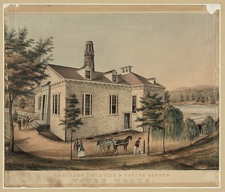
Spring Garden is a neighborhood in central Philadelphia, Pennsylvania, United States, bordering Center City on the north. Spring Garden is a neighborhood that combines diverse residential neighborhoods and significant cultural attractions. The residential areas on the north side of the neighborhood are composed mostly of brick and brownstone three-story townhouses built during the mid-to-late 19th century. The houses include townhouses in the Italianate style, Second Empire, Queen Anne, and Venetian Gothic. Many streets include "terraced" set ups, which include a small gardened plot, often raised, in front of the house. The residential areas to the south are dominated by taller, multi-family buildings built during the 20th century. The museum area, also to the south of Spring Garden Street, includes the Rodin Museum, the Central Library of Philadelphia, and the Barnes Museum. Before consolidation of Philadelphia, Spring Garden was a district of Philadelphia County.

The River Wards is a section of Philadelphia, Pennsylvania, United States located along the Delaware River to the northeast of Center City Philadelphia. 'River Wards' is the commonly used name for an area including several neighborhoods, such as Fishtown, Kensington, Port Richmond and Olde Richmond. The River Wards are located at the border of North Philadelphia and Northeast Philadelphia, and may be considered part of one or the other, or as a separate entity. The area is sometimes also known as 'Kensington-Richmond'.
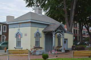
Palmer Cemetery, originally known as the Kensington Burial Grounds, was established around 1732 in the Fishtown section of Philadelphia.
Olde Richmond is a neighborhood in the River Wards section of Philadelphia, Pennsylvania, United States. It is notable for its historically large Polish immigrant, Polish American community, and Irish American community. The U.S. ZIP Code for Olde Richmond is 19125 and its post office is located at 1602 Frankford Avenue.

