Pennsport, Philadelphia

Last updated
Pennsport
USS Philly 1799-250px.jpg
Drawing of the USS Philadelphia, built in Joshua Humphreys' shipyard in Pennsport, 1799.
Street map of Philadelphia and surrounding area.png
Red pog.svg
Pennsport
Coordinates: Coordinates: 39°55′39″N75°09′02″W / 39.92750°N 75.15056°W / 39.92750; -75.15056
CountryFlag of the United States.svg  United States
State Pennsylvania
County Philadelphia County
City Philadelphia
ZIP Code
19147, 19148
Area code(s) Area codes 215, 267, and 445

Pennsport is a neighborhood in the South Philadelphia section of Philadelphia, Pennsylvania, United States.

Contents

Pennsport is home to a large working-class Irish American population, many of them descendants of immigrants from the mid to late 19th century. They maintain social organizations (also called "clubs"), which are located along 2nd Street (known locally as "Two Street"). [1] Each year the clubs spend months preparing costumes, music and performances for Philadelphia's annual Mummers Parade on Broad Street on New Year's Day.

At one time Pennsport was proposed as a location for development of casinos along the Philadelphia waterfront. [2] [3] Many residents opposed this. They wanted development that would provide better jobs. The state and city had conducted some negotiations with the Mashuntucket Pequot, whose reservation is based in Connecticut, to establish Foxwoods Casino Philadelphia in this neighborhood, but it never gained approval.

Location

Pennsport is bounded by the Delaware River to the east, the Queen Village neighborhood to the north, Whitman to the south, and Dickinson Square West to the west. The Pennsport Redevelopment Area Plan of 1968 listed the border streets as Washington Avenue on the north, Snyder Avenue on the south, and Fourth Street on the west. [4]

Demographics

The 2000 census listed Pennsport's population as 26,300, but this figure includes the populations of Southwark, Queen Village, and Whitman neighborhoods. [5]

Pennsport's population identifies as 70% white, 17% African American, 8% Asian American, and 5% Hispanic and Latino American, of any race. Roughly 40% of the population is under 18. [5]

History

"The building of the Frigate Philadelphia", Plate 29 of Birch's Views of Philadelphia (1800). The man standing in the foreground may be a portrait of Humphreys. Preparation for War to defend Commerce Birch's Views Plate 29.jpg
"The building of the Frigate Philadelphia", Plate 29 of Birch's Views of Philadelphia (1800). The man standing in the foreground may be a portrait of Humphreys.
The Grand Battery Historical Marker The Grand Battery Historical Marker S Columbus Blvd at US Coast Guard Station Philadelphia PA (DSC 2949).jpg
The Grand Battery Historical Marker
Washington Avenue Immigration Station Historical Marker Washington Avenue Immigration Station Historical Marker 1 Washington Ave Philadelphia PA (DSC 2703).jpg
Washington Avenue Immigration Station Historical Marker

According to the Genealogy of Philadelphia County Subdivisions, Pennsport was originally part of Moyamensing Township. Most of the area north of present-day Mifflin Street was included in the Southwark District from 1794 until the consolidation of Philadelphia in 1854. At that point, it was mostly contained in the First Ward. The First and Second wards ran east of Passyunk Avenue and were divided by Wharton Street (First to the south, Second to the north). The southern boundary of the First Ward initially spanned south to the river, but it was stopped at Mifflin Street in 1898. [6]

The Washington Avenue Immigration Station was an immigrant processing facility located at the end of Washington Avenue at Pier 53 on the Delaware River. It operated from 1873 to 1915.

During King George's War in 1748, a young Benjamin Franklin erected the "Association Battery" or "Grand Battery" here along the river. These were earthwork defenses fitted with artillery. [7]

The first United States naval yard started in the 1770s as a private commercial yard located in what is now Pennsport at Federal Street on the Delaware River. [8] It was owned and operated by noted shipbuilder Joshua Humphreys. He designed the original six frigates of the United States Navy. In addition, the frigate USS Philadelphia, not one of those six, was also built at what became the official navy yard.

The naval yard was designated for the US Navy in 1801 and was active until 1875. That year it was relocated to new facilities built on League Island. The shipyard expanded to support production and repair of ships. During World War II, some 40,000 people worked here in shifts that operated 24 hours a day.

The shipyard was closed in 1991, as a result of a decision by the Base Realignment and Closure Commission. Nearly 1000 acres was transferred to the City of Philadelphia for redevelopment. What is known as The Navy Yard has been developed for businesses and manufacturing. A part of the site is still devoted to shipbuilding. [9] [10]

The neighborhood has other buildings and structures of historic interest. Furness High School and the former Abigail Vare School are listed on the National Register of Historic Places. [11] The Historic rowhouse synagogue, Congregation Shivtei Yeshuron-Ezras Israel, was featured in the Hidden City Philadelphia 2013 Festival. [12]

Education

The Vare-Washington School, in the former Washington School in Dickinson Square West, serves Pennsport. Vare-Washington Elementary School Philadelphia (DSC 2053).jpg
The Vare-Washington School, in the former Washington School in Dickinson Square West, serves Pennsport.
Whitman Branch of the Free Library of Philadelphia Phila FLP Whitman.jpg
Whitman Branch of the Free Library of Philadelphia

The School District of Philadelphia operates public schools serving Pennsport.

Vare-Washington School serves grades K-8. [13] The school was previously named Abigail Vare School and had occupied a building in Pennsport. [14] [15] In October 2013 the Philadelphia School Reform Commission (SRC) voted to close Washington School in Dickinson Square West. Abigail Vare School moved from its previous building to the former Washington building at 1198 South 5th Street. [16]

Furness High School also serves area residents. [17]

Public libraries

The Free Library of Philadelphia Whitman Branch in Whitman serves Pennsport. [18]

Notable residents

Bronze statues of William “Wild Bill” Guarnere and Edward “Babe” Heffron have been installed at a park on 2nd and Reed Streets. It portrays the pair as young men, as they looked just before leaving Pennsport to fight in Europe during World War II.

Related Research Articles

<span class="mw-page-title-main">South Philadelphia</span> Neighborhood of Philadelphia, Pennsylvania

South Philadelphia, nicknamed South Philly, is the section of Philadelphia bounded by South Street to the north, the Delaware River to the east and south and the Schuylkill River to the west. A diverse working-class community of many neighborhoods, South Philadelphia is well-known for its large Italian-American population, but it also contains large Asian American, Irish-American, African-American, and Latino populations.

William Guarnere US Army soldier

William J. Guarnere Sr. was a United States Army paratrooper who fought in World War II as a non-commissioned officer with Easy Company, 2nd Battalion, 506th Parachute Infantry Regiment, in the 101st Airborne Division.

<span class="mw-page-title-main">Schuylkill Expressway</span> Highway in Pennsylvania

The Schuylkill Expressway, locally known as "the Schuylkill", is a two to eight lane freeway through southern Montgomery County and the city of Philadelphia in Philadelphia County, and the easternmost segment of Interstate 76 (I-76) in the U.S. state of Pennsylvania. It extends from the Valley Forge exit of the Pennsylvania Turnpike in King of Prussia, paralleling its namesake Schuylkill River for most of the route, southeast to the Walt Whitman Bridge over the Delaware River in South Philadelphia. It serves as the primary corridor into Philadelphia from points west. Maintenance and planning are administered through Pennsylvania Department of Transportation (PennDOT) District 6, with the Delaware River Port Authority (DRPA) maintaining the approach to the Walt Whitman Bridge.

<span class="mw-page-title-main">Southwest Center City, Philadelphia</span> Neighborhood of Philadelphia in Philadelphia, Pennsylvania

Southwest Center City (SWCC), also known as Graduate Hospital, is a neighborhood in South Philadelphia bordering Center City Philadelphia. The neighborhood is bordered on the north by South Street, on the south by Washington Avenue, on the west by the Schuylkill River, and on the east by Broad Street. It is an area adjacent to the Fitler Square and Rittenhouse Square neighborhoods to the north and Point Breeze to the south. It is home to several community service organizations, restaurants, many churches, a few retail establishments, and some light industry.

Queen Village, Philadelphia Neighborhood of Philadelphia in Philadelphia County, Pennsylvania, United States

Queen Village is a residential neighborhood of Philadelphia, Pennsylvania that lies along the eastern edge of the city in South Philadelphia. It shares boundaries with Society Hill to the north, Bella Vista to the west and Pennsport to the south. Historically, the area is part of old Southwark, Philadelphia's first suburb, which was incorporated into the city in 1854 and remains the city's oldest residential neighborhood. Street boundaries are the south side of Lombard Street to the north side of Washington Avenue, the Delaware River to 6th Street, encompassing two principal commercial corridors, South Street and Fabric Row on 4th Street.

Point Breeze, Philadelphia Neighborhood of Philadelphia in Philadelphia County, Pennsylvania, United States

Point Breeze is a multicultural neighborhood in South Philadelphia in Philadelphia, Pennsylvania, United States. It is bounded by 25th Street to the west, Washington Avenue to the north, 18th Street to the east, and Moore Street to the south. Graduate Hospital lies to its north, and Newbold lies to its east. Point Breeze is separated from Grays Ferry to the west by a CSX railway viaduct over 25th Street.

Grays Ferry, Philadelphia Neighborhood of Philadelphia in Philadelphia County, Pennsylvania, United States

Grays Ferry, also known as Gray's Ferry, is a neighborhood in South Philadelphia bounded (roughly) by 25th Street on the east, the Schuylkill River on the west, Vare Avenue on the south, and Grays Ferry Avenue on the north. The section of this neighborhood west of 34th Street is also known as Forgotten Bottom. Grays Ferry shares borders with Southwest Center City to the North, Point Breeze to the East, and Girard Estate to the South. Gray’s Ferry is across from where Mill Creek debouches at about 43rd street. Historically, Grays Ferry was one of the largest enclaves of Irish Americans in the city, and while there are still many Irish left, it is now home to a significant African American population.

<span class="mw-page-title-main">Tacony, Philadelphia</span> Neighborhood of Philadelphia in Philadelphia County, Pennsylvania, United States

Tacony is a historic neighborhood in Northeast Philadelphia, about 8 miles (13 km) from downtown Philadelphia. It is bounded by the east side of Frankford Avenue on the northwest, the south side of Cottman Avenue on the northeast, the north side of Robbins Street on the southwest, and the Delaware River and Interstate 95 on the southeast.

Southwark, Philadelphia Former District in Pennsylvania, United States

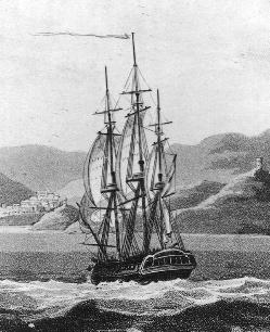
Southwark was originally the Southwark District, a colonial-era municipality in Philadelphia County, Pennsylvania. Today, it is a neighborhood in the South Philadelphia section of Philadelphia, Pennsylvania. Because of its location south of the early Philadelphia, the name was adopted in allusion to the borough of Southwark in the county of London, England, just south of the city of London.

<span class="mw-page-title-main">Whitman, Philadelphia</span> Neighborhood of Philadelphia in Philadelphia County, Pennsylvania, United States

Whitman is a neighborhood in the South Philadelphia section of Philadelphia, Pennsylvania, United States. It is bounded on the west by Sixth Street, on the east by Front Street, on the south by Bigler Street, and on the north by Snyder Avenue. The name "Whitman" was adopted when the nearby Walt Whitman Bridge was being constructed in the 1950s. In 2015, Whitman and nearby South Philadelphia neighborhoods were named by Philadelphia Magazine as one of the safest and most family-friendly neighborhoods in Philadelphia.

<span class="mw-page-title-main">Edward Heffron</span>

Edward James "Babe" Heffron was a private with E Company, 2nd Battalion, 506th Parachute Infantry Regiment, in the 101st Airborne Division of the United States Army during World War II. Heffron was portrayed in the HBO miniseries Band of Brothers by Robin Laing. Heffron wrote Brothers in Battle, Best of Friends: Two WWII Paratroopers from the Original Band of Brothers Tell Their Story with fellow veteran William "Wild Bill" Guarnere and journalist Robyn Post in 2007.

Furness High School United States historic place

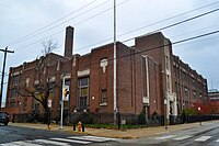
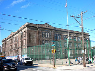
Horace Howard Furness High School is a secondary (9th-12th) school in South Philadelphia. It is part of the School District of Philadelphia.

Lower Moyamensing, Philadelphia Neighborhood of Philadelphia in Philadelphia County, Pennsylvania, United States

Lower Moyamensing is a neighborhood in South Philadelphia just south of the East Passyunk Crossing neighborhood and north of the stadium area. It is bounded by Snyder Avenue to the north, Oregon Avenue to the south, South 7th Street to the east, and South Broad Street to the west. The neighborhood was once part of Moyamensing Township before becoming part of Philadelphia in 1854. Lower Moyamensing is known for its 19th century row homes, factory buildings, and variety of restaurants. South Philadelphia High School is located in Lower Moyamensing, at the corner of Broad and Jackson Streets.

Vare-Washington School United States historic place

Vare-Washington School, is a K-8 school in South Philadelphia, Pennsylvania. It is a part of the School District of Philadelphia. It occupies the former George Washington School building in the Dickinson Narrows neighborhood, in proximity to Southwark.

Dickinson Square West, Philadelphia Neighborhood of Philadelphia in Philadelphia County, Pennsylvania, United States

Dickinson Square West, Philadelphia is a neighborhood in South Philadelphia bordered by neighborhoods Queen Village to the north, Whitman to the south, Pennsport to the east and Passyunk Square and East Passyunk Crossing to the west. The neighborhood was previously referred to as "Dickinson Narrows", but was officially reestablished as "Dickinson Square West" in 2013 by the Registered Community Organization, Dickinson Square West Civic Association, located within its boundaries. In October, 2018, The Dickinson Square West Civic Association passed an amendment to expand the southern boundary from Mifflin Street to Snyder Ave

<span class="mw-page-title-main">Congregation Shivtei Yeshuron-Ezras Israel</span>

Congregation Shivtei Yeshuron Ezras Israel is an active synagogue located in the Pennsport neighborhood of South Philadelphia. The congregation moved to its current location in 1909 and had purchased the building by 1917. It is South Philadelphia's oldest continuously active synagogue building and congregation. Religious services are lay led, and the congregation offers cultural events and tours open to the public.

Little Saigon, Philadelphia Neighborhood of Philadelphia in Philadelphia County, Pennsylvania, United States

One of the largest Vietnamese neighborhoods in Philadelphia is located in Passyunk Square, a neighborhood in South Philadelphia.

Abigail Vare School United States historic place

Abigail Vare School is a former school building located in the Pennsport neighborhood of Philadelphia, Pennsylvania. It is located across from Dickinson Square Park.

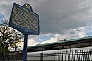
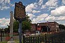
Mount Sinai Hospital was a hospital in Philadelphia in the United States, from 1905 to 1997.

References

  1. Max L. Raab (2001). Strut! The Movie (DVD). Philadelphia: Max L. Raab Productions. Archived from the original on 2007-10-09. Retrieved 2017-02-19.
  2. Philly.com article on casino proposals
  3. Philadelphia Weekly article on resident response to the casinos
  4. Pennsport Redevelopment Area Plan (Nov. 1968), Philadelphia Neighborhoods Project, University of Pennsylvania Libraries.
  5. 1 2 South Philly Review , October 7, 2004, "The Place Where You Live: Pennsport".
  6. Weinberg, Allen; John Daly (1966). Genealogy of Philadelphia County Subdivisions. Philadelphia: City of Philadelphia Department of Records.
  7. Harbor Defenses of the Delaware
  8. "The Federal Road: Arsenal to Navy Yard". 14 October 2006.
  9. http://www.philaplace.org/resources/South%20Philadelphia%20Timeline.pdf [ bare URL PDF ]
  10. http://www.navyyard.org/
  11. "National Register Information System". National Register of Historic Places . National Park Service. July 9, 2010.
  12. Myers, Joseph (May 23, 2013). "Hidden City showcases Shivtei Yeshuron: A local synagogue will participate in a celebration of often-overlooked spaces". South Philly Review . Retrieved 2014-01-12.
  13. "School Finder." School District of Philadelphia. Retrieved on November 30, 2015.
  14. Former Abigail Vare attendance boundary (Archive). School District of Philadelphia. Retrieved on November 30, 2015.
  15. Jennings, James. "Mt. Sinai Developer Plans Apartments, Townhomes at Shuttered Pennsport School." Philadelphia . June 10, 2015. Retrieved on November 30, 2015.
  16. Graham, Kristen. "SRC votes to spare four schools." Philadelphia Inquirer . Thursday, October 17, 2013. Retrieved on November 30, 2015. "CLOSING:[...]George Washington Elementary School, 1198 S. 5th Street Abigail Vare Elementary School, 1621 E. Moyamensing Avenue (building only, moves into George Washington Elementary)"
  17. "Horace Furness High School Geographic Boundaries" (Archive). School District of Philadelphia. Retrieved on October 4, 2011.
  18. "Whitman Branch." Free Library of Philadelphia. Retrieved on October 19, 2012.