
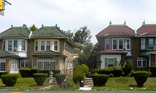
Wynnefield is a diverse middle-class neighborhood in West Philadelphia. Its borders are 53rd Street at Jefferson to the south, Philadelphia's Fairmount Park to the east, City Avenue to the north and the Amtrak Philadelphia Main Line tracks to the west.

Overbrook is an historic neighborhood that is located in the Commonwealth of Pennsylvania, United States. It is situated northwest of West Philadelphia, Philadelphia.

Center City includes the central business district and central neighborhoods of Philadelphia. It comprises the area that made up the City of Philadelphia prior to the Act of Consolidation, 1854, which extended the city borders to be coterminous with Philadelphia County.

Olney is a neighborhood in North Philadelphia, Pennsylvania, United States. It is roughly bounded by Roosevelt Boulevard to the south, Tacony Creek to the east, Godfrey Avenue to the north, and the railroad right-of-way west of Seventh Street to the west.

Ogontz/Belfield is a neighborhood in Upper Northern Philadelphia that is located adjacent to West Oak Lane, East Germantown, Logan, and Fern Rock, Philadelphia, Pennsylvania, United States.

West Kensington is a neighborhood in the North Philadelphia section of Philadelphia, Pennsylvania, United States. It is north of Olde Kensington. The Market Frankford El above Front Street forms the line between West Kensington and Kensington. Its bordering neighborhoods are Kensington to the east, Hartranft to the west, and Olde Kensington to the south. It is bounded by Front Street to the east, 6th Street to the west, Cecil B. Moore Avenue to the South and Lehigh Avenue to the north. It falls into the 19122 and 19133 ZIP Codes.
East Oak Lane is a neighborhood at the northern end of the North Philadelphia planning district of Philadelphia, Pennsylvania, United States. Many of the houses in the neighborhood are large single homes or twins built at a later period than much of central North Philadelphia. There is also a significant number of typical Philadelphia rowhouses.
Cobbs Creek is a neighborhood located in the West Philadelphia section of Philadelphia, Pennsylvania, United States, named for the creek which forms part of Philadelphia's western border. Cobbs Creek is generally bounded by Market Street to the north, Baltimore Avenue to the south, 52nd Street to the east, and the border of Upper Darby along Cobbs Creek to the West.

Point Breeze is a multicultural neighborhood in South Philadelphia in Philadelphia, Pennsylvania, United States. It is bounded by 25th Street to the west, Washington Avenue to the north, 18th Street to the east, and Moore Street to the south. Graduate Hospital lies to its north, and Newbold lies to its east. Point Breeze is separated from Grays Ferry to the west by a CSX railway viaduct over 25th Street.
Logan is a neighborhood in the upper North Philadelphia section of the city of Philadelphia, in the U.S. state of Pennsylvania. The majority of the neighborhood falls within the 19141 zip code, but some of it falls within 19140. The neighborhood is sometimes confused with the Olney neighborhood of Philadelphia. Olney Avenue extends from both the Olney and Logan neighborhoods of the city. The Olney Transportation Center is located in Logan.

Hartranft is a neighborhood in the central part of North Philadelphia section of Philadelphia, Pennsylvania, United States.
Fairhill is a neighborhood on the east side of the North Philadelphia section of Philadelphia, Pennsylvania, United States. Fairhill is bordered by Front Street to the east, Germantown Avenue to the west, Allegheny Avenue to the north, and Cumberland Street to the south. The neighborhood serves as the center of the Hispanic community of Philadelphia, and is known for its "El Centro de Oro" commercial strip along North 5th Street. Fairhill is adjacent to Harrowgate and West Kensington to the east, Hartranft to the south, Glenwood to the west, and Hunting Park to the north.

Hawthorne is a neighborhood in the South Philadelphia section of Philadelphia, Pennsylvania, United States. It is located between Broad Street and 11th Street, and extends from South Street to Washington Avenue.

The Dallas Public Library system serves as the municipal library system of the city of Dallas, Texas (USA).

Haddington is a neighborhood in the West Philadelphia section of Philadelphia, Pennsylvania, United States. Its borders are defined as Haverford Avenue/Girard Avenue to the north, 52nd Street to the east, Market Street to the south, and 67th Street to the westernmost edge of the neighborhood.

Castor Gardens is a neighborhood in the lower Northeast section of Philadelphia, Pennsylvania, United States. Castor Gardens' borders are not clearly defined, but it exists in the vicinity of Castor Avenue and Cottman Avenue. It is also near Roosevelt Boulevard. The neighborhood can either be entered from the south, by taking the Oxford Circle exit of Roosevelt Boulevard, or from the north, by taking the Cottman Avenue exit. Adjacent neighborhoods are Mayfair, Lawndale, Burholme, Oxford Circle, and Rhawnhurst.

Central South Philadelphia, commonly known as either just South Philadelphia or "South Philly," is a neighborhood in South Philadelphia, Pennsylvania, United States. It is generally bounded by Broad to 9th Streets and Mifflin to Shunk. The entire neighborhood falls under the 19148 zip code. The neighborhood has a large Italian American population.

Carroll Park is a neighborhood in West Philadelphia, Pennsylvania, United States. Its boundaries are Lansdowne Avenue to the north, West Girard Avenue to the south, North 63rd Street to the west, and North 52nd Street to the east. Along major streets of the neighborhood, the Carroll Park Community Council, Inc. has placed banners that say “Carroll Park: Where our neighbors become friends.” The 10 trolley runs along Lansdowne Avenue and the 15 trolley runs along Girard Avenue. There is a park by the name of Carroll Park between North 59th and North 58th Streets and West Thompson Street and West Girard Avenue. Carroll Park’s residents are primarily working-class and lower-income African-Americans.
Cathedral Park is a small neighborhood in the West Philadelphia section of Philadelphia, Pennsylvania, United States. Its boundaries are North 52nd Street to the west, West Girard Avenue and the Old Cathedral Cemetery to the south, and the SEPTA regional rail tracks to the north and east. Lancaster Avenue passes through the eastern portion of the neighborhood, parallel to the SEPTA tracks. SEPTA’s 10 trolley serves the neighborhood via Lancaster Avenue. A prominent landmark in the neighborhood is the former St. Gregory Roman Catholic Church, located at North 52nd Street and Warren Street. Today, the Greater Bible Way Temple utilizes the building. Across the street from the former St. Gregory church, at the intersection of Media Street and North 52nd Street, is the former George Institute Branch Library of the Free Library of Philadelphia. On January 9, 2011, a fire destroyed the former St. Gregory Parochial School building. At the time of the fire, the building served as the home for the Global Leadership Academy Charter School.

