Fairhill, Philadelphia

Last updated

Fairhill
Phila FLP LehighAvenue02.png
Lillian Marrero Library in Fairhill
Street map of Philadelphia and surrounding area.png
Red pog.svg
Fairhill
Location in Philadelphia
Coordinates: 39°59′40″N75°08′42″W / 39.99444°N 75.14500°W / 39.99444; -75.14500
CountryFlag of the United States (23px).png  United States
State Pennsylvania
County Philadelphia
City Philadelphia
Area code(s) 215, 267 and 445

Fairhill is a neighborhood on the east side of the North Philadelphia section of Philadelphia, Pennsylvania, United States. Fairhill is bordered by Front Street to the east, Germantown Avenue (10th Street) to the west, Allegheny Avenue to the north, and Cumberland Street to the south. [1] The neighborhood serves as the center of the Hispanic community of Philadelphia, and is known for its "El Centro de Oro" commercial strip along North 5th Street. [2] Fairhill is adjacent to Harrowgate and West Kensington to the east, Hartranft to the south, Glenwood to the west, and Hunting Park to the north. [3]

Contents

History

The area that is now the Fairhill neighborhood was at one time home to the Isaac Norris family's Fair Hill estate. Norris was an early merchant and later mayor of Philadelphia. It is also home to the Fair Hill Burial Ground, a cemetery that Quakers established in 1703. [4] George Fox obtained the land for the cemetery from William Penn. The cemetery is on the National Register for Historic Places.

Fairhill began to develop its urban character in the 1880s. Many of the new residents at this time were German immigrants, particularly German Catholics. [5] With the approval of the Archdiocese and the help of Fr. Henry Stommel of Doylestown, the German Catholic families in the area established Saint Bonaventure Parish (also known as Saint Bonaventura) in 1890. The original parish building was at Ninth and Auburn Streets. After establishing the parish, Fr. Stommel turned over its leadership to Fr. Hubert Hammeke, a German immigrant priest. In 1894, the parish began building a Gothic style church. Fr. Hammeke served as the project manager for the church's construction and construction on the new church finished in 1906. The finished church at Ninth and Cambria Streets included an impressive clock tower and spire. Fr. Hammeke would lead the parish until his death in 1937.

In the 1950s, the demographics of the Fairhill area began to change. [5] The German-American families began leaving the neighborhood with African-Americans and Latinos – mainly Puerto Ricans – taking their place. By 1975, the parish had initiated a Spanish mass and a Carino Center for Spanish-speaking children. The parish, including the school, closed in 1993; St. Bonaventure Parish church was demolished in 2013–14. [6]

Geography

El Centro de Oro

El Centro de Oro ("The Golden Downtown"), also known as "El Bloque de Oro," ("Golden Block"), is a commercial district located at 5th Street and Lehigh Avenue. [7] [8] It includes notable Puerto Rican businesses and organizations such as Taller Puertorriqueño (Puerto Rican Workshop), Asociación Puertorriqueños en Marcha (Association of Puerto Ricans on the March), and Artístas y Músicos Latino Americanos (Latin American Artists and Musicians). [9] [10] [11] [12]

El Centro de Oro was established in the 1970s by community leaders from an older Latino community that was in the process of being displaced from the Spring Garden area as a result of gentrification. Organizations such as El Concilio de Organizaciones Hispanas de Filadelfia (Council of Spanish-speaking Organizations of Philadelphia) and the Spanish Merchants Association of Philadelphia encouraged Latino businesses and organizations to move to the Fairhill and Kensington neighborhoods and worked to develop Latino and Puerto Rican-oriented housing, cooperatives, and social service organizations. [13]

Demographics

As of the census [14] of 2010, the racial makeup of Fairhill is 80.2% Hispanic of any race, 15.1% non Hispanic Black, 2.3% non Hispanic White, 1.4% Asian, and 1% all other. [14] [15] It has the highest concentration of Hispanics of any neighborhood in Philadelphia, which is over 10 times larger than the overall percentage of Hispanics living in Philadelphia. The neighborhood is mainly made up of Puerto Ricans, But also has significant populations of Dominicans, Cubans, Colombians, and Brazilians, as well as other Hispanics. Its poverty rate is 61%, which is about five times the national average, as of Census 2010. [16] The neighborhood is sometimes nicknamed "El Centro de Oro" (Spanish for "the center of gold"), and is considered to be the center of the city's Hispanic community.

Fairhill, among other areas of eastern North Philadelphia, is known for having some of the highest concentrations of Puerto Ricans in the United States outside Puerto Rico (which is a US territory). [17] [18] Furthermore, the area west of 5th street is over two-thirds Hispanic, with the remaining nearly one-third being black, while areas of the neighborhood east of 5th street are nearly 100 percent Hispanic. [17] [18] [19] [20]

In 2002 23.5% of the houses in Fairhill were occupied by the owners. 85% of the housing in Fairhill consists of row houses. 2.6% of the buildings in the area are zoned for commercial use; Steve Volk of Philadelphia Weekly stated that efforts to replace drug dealing with legitimate commercial activity have been stymied in recent years. [21] As of Census 2010, Zip Code 19133 which encompasses most of Fairhill and portions of neighboring Glenwood and Hartranft, is the poorest zip code in Philadelphia, having a poverty rate of 61% and a median household income of $14,185. [16] [22]

Crime

Steve Lopez's novel Third and Indiana made the intersection well known. [23] [24] The intersection of 3rd Street and Indiana Avenue was listed as number two in a 2007 list of the city's top ten recreational drug corners according to an article by Philadelphia Weekly reporter Steve Volk. Other intersections in Fairhill included in the list of the top drug corners included Fifth Street and Westmoreland Street in third place, and A Street and Westmoreland Street in seventh place. [24]

Philadelphia Badlands

The Philadelphia Badlands is a section of North Philadelphia and Lower Northeast Philadelphia, in Pennsylvania that is known for an abundance of open-air recreational drug markets and drug-related violence. [25] It has amorphous and somewhat disputed boundaries, but is generally agreed to include the 25th police district. [26]

Usually, it is widely understood to be an area between Kensington Avenue to the east and Broad Street to the west, and between Hunting Park Avenue to the north and York Street to the south, mostly coinciding with the neighborhoods of Fairhill, Glenwood, Hunting Park, Harrowgate, Stanton, North Central, West Kensington, Hartranft, and Kensington.

The term "The Badlands" was popularized in part by the novel Third and Indiana by then Philadelphia Inquirer columnist Steve Lopez. [25] The neighborhood also was featured in several episodes of ABC's Nightline . The intersection of 3rd Street and Indiana Avenue was listed number two in a 2007 list of the city's top ten drug corners according to an article by Philadelphia Weekly reporter Steve Volk. [27]

The term Badlands was first used by Lt. John Gallo, who headed the East Division Narcotics Task Force[ citation needed ]. Its use spread, with many people attempting to take credit for the moniker. It was Gallo's work along with ASAC Billy Retton that worked about a dozen long-term investigations in the 25th and 26th Police Districts that preceded "Operation Sunrise". Ted Koppel, Geraldo Rivera, 20/20 and 48 Hours all rode with Gallo at one time or another, and it was during this time that Gallo was able to make the name stick.[ citation needed ]

At one time a center of heavy industry, much of the Badlands' urban landscape is now characterized by vacant warehouses and tightly-packed strips of brick row houses constructed for the working class of the neighborhood. Like most industrial cities in the eastern United States, Philadelphia suffered economic decline following the movement of industry to either the suburbs or developing countries and has suffered as a result.

The Philadelphia Badlands contain a diverse mix of ethnicities. Puerto Ricans are the largest group, [28] [29] [30] [31] but the area also contains large populations of Black Americans, Irish Americans, and Dominican Americans. The area encompasses El Centro de Oro, the heart of Philadelphia's Puerto Rican community. [32] Although much of the area's crime stems from local neighborhood-based street gangs and the drug trade, larger, more organized gangs also operate in the area, including the Black Mafia, Latin Kings, and various motorcycle gangs. [32]

Aside from less-organized gang activity, the Badlands is also known as the founding location and current turf of the Irish-American organized crime group known as the K&A Gang (also known as the Northeast Philly Irish Mob). Circa 2012, Irish Americans constitute more than 12% of the population of the Badlands. [33]

The area's reputation has been countered by community activists and nonprofit organizations such as Centro Nueva Creación, which in 2010 conducted a summer children's program, "The Goodlands Photographers", aimed at helping young people photograph and display positive images of their neighborhood. [26]

Government and infrastructure

The United States Post Office operates the Fairhill Post Office in Suite 2 at 217 West Lehigh Avenue. [34]

Education

School District of Philadelphia operates public schools. Fairhill School, a K-8 school, serves Fairhill. [35] Residents zoned to Fairhill School are also zoned to Thomas Alva Edison High School / John C. Fareira Skills Center. [36] Fairhill Community High School (FCHS), an alternative charter high school for dropouts and students at risk for dropping out, is located in Fairhill. [37]

The Free Library of Philadelphia Lillian Marrero Library serves Fairhill. [38] It was previously the Lehigh Avenue Branch, and Lillian E. Marrero had served as the library's supervisor. [39]

See also

Related Research Articles

<span class="mw-page-title-main">Hunting Park, Philadelphia</span> Neighborhood of Philadelphia in Pennsylvania, United States

Hunting Park is a neighborhood in the North Philadelphia section of the United States city of Philadelphia, Pennsylvania.

<span class="mw-page-title-main">West Philadelphia</span> Neighborhood of Philadelphia, Pennsylvania

West Philadelphia, nicknamed West Philly, is a section of the city of Philadelphia. Although there are no officially defined boundaries, it is generally considered to reach from the western shore of the Schuylkill River, to City Avenue to the northwest, Cobbs Creek to the southwest, and the SEPTA Media/Wawa Line to the south. An alternate definition includes all city land west of the Schuylkill; this would also include Southwest Philadelphia and its neighborhoods. The eastern side of West Philadelphia is also known as University City.

<span class="mw-page-title-main">Kensington, Philadelphia</span> Neighborhood in Philadelphia, Pennsylvania

Kensington is a neighborhood in Philadelphia that belongs to Lower Northeast. As with all neighborhoods in the city, the lack of any official designation means the boundaries of the area vary between sources over time and are disputed among locals. Kensington, as most long-term residents view it, refers generally to the area consisting of Kensington, East Kensington, West Kensington, and Harrowgate. The adjacent Fairhill and Norris Square neighborhoods are more separate but may be included in Kensington; Fishtown and South (Olde) Kensington were historically included. The most conservative boundaries of the neighborhood, shown in the map below, are Front Street and 5th Street to the west, the Amtrak train tracks to the North, Trenton Avenue, the Trenton Avenue train tracks, and Frankford Avenue to the east, and Cecil B. Moore Avenue to the south.

<span class="mw-page-title-main">North Philadelphia</span> Neighborhood of Philadelphia in Philadelphia, Pennsylvania

North Philadelphia, nicknamed North Philly, is a section of Philadelphia, Pennsylvania. It is immediately north of Center City. Though the full extent of the region is somewhat vague, "North Philadelphia" is regarded as everything north of either Vine Street or Spring Garden Street, between Northwest Philadelphia and Northeast Philadelphia. It is bordered to the north by Olney Ave along Broad Street, Spring Garden Street to the south, 35th Street to the west and Adams Avenue to the east. The Philadelphia Police Department patrols five districts located within North Philadelphia: the 22nd, 25th, 26th, 35th and 39th districts. There are thirteen ZIP codes for North Philadelphia: 19120, 19121, 19122, 19123, 19125, 19126, 19130, 19132, 19133, 19134, 19137, 19140 and 19141.

<span class="mw-page-title-main">Port Richmond, Philadelphia</span> Neighborhood in Philadelphia, Pennsylvania, United States

Port Richmond is a neighborhood in the River Wards section of Philadelphia, Pennsylvania, United States. It is notable for its extremely large Polish immigrant and Polish American community. The neighborhood is also home to a large Irish American community and sizable German and Italian communities as represented in the various churches and organizations. In more recent years, a sizable Albanian community has moved in. The Richmond Zip Code is 19134. A small portion of the neighborhood, north of Castor Avenue, falls into the 19137 ZIP code.

<span class="mw-page-title-main">West Kensington, Philadelphia</span> Neighborhood of Philadelphia in Pennsylvania, United States

West Kensington is a neighborhood in the North Philadelphia section of Philadelphia, Pennsylvania, United States. It is north of Olde Kensington. The Market Frankford El above Front Street forms the line between West Kensington and Kensington. Its bordering neighborhoods are Kensington to the east, Hartranft to the west, and Olde Kensington to the south. It is bounded by Front Street to the east, 6th Street to the west, Cecil B. Moore Avenue to the South and Lehigh Avenue to the north. It falls into the 19122 and 19133 ZIP Codes.

<span class="mw-page-title-main">Hartranft, Philadelphia</span> Neighborhood of Philadelphia, Pennsylvania, US

Hartranft is a neighborhood in the central part of North Philadelphia section of Philadelphia, Pennsylvania.

<span class="mw-page-title-main">Feltonville, Philadelphia</span> Neighborhood of Philadelphia in Pennsylvania, United States

Feltonville is a working-class neighborhood in North Philadelphia, Pennsylvania, United States. It is located east of Logan and Hunting Park, west of Lawncrest and Juniata, south of Olney, and north of Fairhill and Harrowgate. Feltonville is bounded by Erie Avenue to the south, Front Street to the west, Roosevelt Boulevard to the north, Tacony Creek to the northeast, and G Street to the east.

Harrowgate is a neighborhood in the River Wards section of Philadelphia, Pennsylvania, United States, located immediately northeast of Kensington adjacent to Kensington Avenue. It is bordered by Feltonville, Juniata and Frankford to the north, Fairhill to the west, West Kensington and Kensington to the south, and Port Richmond and Bridesburg to the east.

<span class="mw-page-title-main">Demographics of Philadelphia</span>

At the 2010 census, there were 1,526,006 people, 590,071 households, and 352,272 families residing in the consolidated city-county of Philadelphia, Pennsylvania. The population density was 4,337.3/km2 (11,233.6/mi2). There were 661,958 housing units at an average density of 1,891.9/km2 (4,900.1/mi2).

<span class="mw-page-title-main">Pura Belpré</span> Puerto Rican writer, puppeteer, and librarian

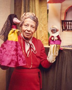
Pura Teresa Belpré y Nogueras was an Afro-Puerto Rican educator who served as the first Puerto Rican librarian in New York City. She was also a writer, collector of folktales, and puppeteer.

<span class="mw-page-title-main">Stateside Puerto Ricans</span> Ethnic group and nationality and citizens of Puerto Rico in the US

Stateside Puerto Ricans, also ambiguously known as Puerto Rican Americans, or Puerto Ricans in the United States, are Puerto Ricans who are in the United States proper of the 50 states and the District of Columbia who were born in or trace any family ancestry to the unincorporated US territory of Puerto Rico.

<span class="mw-page-title-main">Philadelphia Badlands</span> Neighborhood of Philadelphia, PA, US

The Philadelphia Badlands is a section of North Philadelphia and Lower Northeast Philadelphia, in Pennsylvania that is known for an abundance of open-air recreational drug markets and drug-related violence. It has amorphous and somewhat disputed boundaries, but is generally agreed to include the 25th police district.

<i>Third and Indiana</i>

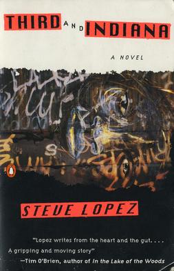
Third and Indiana is a novel written by Steve Lopez about the experiences of several people connected to 14-year-old Gabriel Santoro, while living in the dangerous gang-controlled streets of the Badlands section of Philadelphia, Pennsylvania. The novel gave notoriety to Third Street and Indiana Avenue, a real-life intersection in the Fairhill area known for the prevalence of drug dealers. The first printing had 50,000 copies printed. Published in 1994, it was Lopez's first novel.

<span class="mw-page-title-main">Glenwood, Philadelphia</span> Neighborhood of Philadelphia in Pennsylvania, United States

Glenwood is a neighborhood in North Philadelphia, Pennsylvania, United States. It is located in the vicinity of North Philadelphia Station to West York Street.

Sandra María Esteves is a Latina poet and graphic artist. She was born and raised in the Bronx, New York, and is one of the founders of the Nuyorican poetry movement. She has published collections of poetry and has conducted literary programs at New York City Board of Education, the Caribbean Cultural Center, and El Museo del Barrio. Esteves has served as the executive director of the African Caribbean Poetry Theater. She is the author of Bluestown Mockinbird Mambo and Yerba Buena. She lives in the Bronx.

<span class="mw-page-title-main">Maria Quiñones-Sánchez</span> American politician

Maria Quiñones-Sánchez is an American politician and political activist who served as a member of the Philadelphia City Council representing the 7th district. The district includes the neighborhoods of Castor Gardens, Fairhill, Feltonville, Frankford, Harrowgate, Hunting Park, Juniata, Kensington, Oxford Circle and Wissinoming. A registered Democrat, she served in this position from 2008 to 2022.

<span class="mw-page-title-main">Puerto Ricans in Chicago</span>

Puerto Ricans in Chicago are individuals residing in Chicago with ancestral ties to the island of Puerto Rico. Over more than seventy years, they have made significant contributions to the economic, social, and cultural fabric of the city. This is known as the city of multiple cultures.

<span class="mw-page-title-main">Upper North Philadelphia</span> Neighborhood of Philadelphia in Philadelphia, Pennsylvania

Upper North Philadelphia is a section of Philadelphia that is immediately north of Lower North Philadelphia, and can be described as an area that has a "...large and rapidly growing Puerto Rican population".

<span class="mw-page-title-main">Puerto Ricans in Philadelphia</span> Second largest Puerto Rican community outside of Puerto Rico

Philadelphia has the second largest Puerto Rican community outside of Puerto Rico after New York City. As of the 2010 U.S. Census, an estimated 121,643 Puerto Ricans were living in Philadelphia, up from 91,527 in 2000. Recent 2017 estimates by the U.S. Census Bureau put the number of Puerto Ricans living in Philadelphia at 134,934. In 2019, estimates put the number of Puerto Ricans at 146,153. Many Puerto Ricans in the Philadelphia area have engaged in circular migration in which they spend periods of time living in Philadelphia and periods of time living in Puerto Rico.

References

  1. "Philadelphia Neighborhoods and Place Names, A-K." City of Philadelphia. Retrieved on January 20, 2009. "Front to 10th Streets, Cumberland Street to Allegheny Avenue."
  2. "[press.visitphilly.com/releases/philly-s-el-centro-de-oro-neighborhood-radiates-latino-flavor-culture El Centro de Oro1]." City of Philadelphia. Retrieved on January 1, 2016.
  3. "Fairhill Archived August 8, 2008, at the Wayback Machine ." Plan Philly University of Pennsylvania . Retrieved on January 20, 2009.
  4. . "Fair Hill Burial Ground." Retrieved on February 23, 2011.
  5. 1 2 Archived July 15, 2011, at the Wayback Machine . "History of a Fairhill Block." Retrieved on February 23, 2011.
  6. "St. Bonaventure | Philadelphia Church Project — Philadelphia Church Project". Phillychurchproject.com. November 9, 2008. Archived from the original on March 23, 2016. Retrieved April 3, 2016.
  7. Mandell, Melissa. "El Centro de Oro — The "Golden Block"". philaplace.org. Retrieved June 21, 2013.
  8. Michael Green, Michael (September 17, 2012). "Fairhill: Hispanic Culture and Business Shine on El Bloque de Oro". philadelphianeighborhoods.com. Retrieved June 21, 2013.
  9. Taller Puertorriqueño. Official website. Accessed 2015-11-08.
  10. "PlanPhilly | Taller Puertorriqueño closer to building new cultural center on North 5th". Archived from the original on July 4, 2014.
  11. Asociación Puertorriqueños en Marcha. "About", on official website of APM. Accessed 2015-11-08.
  12. AMLA Artístas y Músicos Latino Americanos. Official website. Successor organization (2006) to Asociación de Músicos Latino Americanos (Association of Latin American Musicians), which was also known as AMLA. Accessed 2015-11-08.
  13. Far, Gail E. "Spanish Merchants Association of Philadelphia 1970-1988". Historical Society of Pennsylvania. Balch Institute. Archived from the original on August 31, 2007.
  14. 1 2 "U.S. Census website". United States Census Bureau . Retrieved 2008-01-31.
  15. "Logan Redevelopment Area Plan Archived July 27, 2011, at the Wayback Machine ." Philadelphia City Planning Commissiom. May 2002. 1 (document page 3). Retrieved on August 2, 2011. "The neighborhood is generally defined as including the area from Wingohocking Street north to Olney Avenue and from Broad Street east to the railroad right-of-way east of Marshall Street. Logan extends west to 16th Street north of Lindley Avenue, where Wakefield Park forms the boundary."
  16. 1 2 "2010 Census". Medgar Evers College. Archived from the original on June 11, 2010. Retrieved 2010-04-13.
  17. 1 2 "Congreso _ Congreso de Latinos Unidos, Inc". Archived from the original on October 6, 2014. Retrieved September 29, 2014.
  18. 1 2 "2010 Census Philadelphia, PA 19133". Zip-codes.com. Retrieved April 3, 2016.
  19. Figueroa, Cynthia (May 17, 2013). "Health disparities in Philadelphia's Latino community". Philly.com. Retrieved April 3, 2016.
  20. "Mapping the 2010 U.S. Census - NYTimes.com". The New York Times. December 13, 2010. Retrieved April 3, 2016.
  21. Volk, Steve. "Neighborhoods." Philadelphia Weekly . August 14, 2002. Retrieved on January 20, 2009.
  22. "Philadelphia 2015: The State of the City" (PDF). The Pew Charitable Trusts. Archived from the original (PDF) on June 6, 2017. Retrieved April 24, 2015.
  23. Volk, Steve. "Trouble Spots: Third and Indiana." Philadelphia Weekly. May 24, 2006. Retrieved on January 19, 2009.
  24. 1 2 Volk, Steve. "Top 10 Drug Corners"; Archived September 7, 2012, at archive.today . Philadelphia Weekly . May 2, 2007. Retrieved on January 20, 2009.
  25. 1 2 Volk, Steve (May 24, 2006). "Trouble Spots: Third and Indiana". Philadelphia Weekly . Archived from the original on September 11, 2012. Retrieved January 19, 2009.
  26. 1 2 Martinez, Vanessa. "Child Photographers Find Good in the Badlands". Philadelphia Inquirer . August 13, 2010. Retrieved on August 17, 2010.
  27. Volk, Steve. "Top 10 Drug Corners Archived September 7, 2012, at archive.today ". Philadelphia Weekly . May 2, 2007. Retrieved on January 20, 2009.
  28. Asquith, C. (2007). The Emergency Teacher: The Inspirational Story of a New Teacher in an Inner-city School . Skyhorse Pub. p.  30. ISBN   9781602391932 . Retrieved August 27, 2015.
  29. Wherry, F.F.; Rocco, T. (2011). The Philadelphia Barrio: The Arts, Branding, and Neighborhood Transformation. University of Chicago Press. p. 187. ISBN   9780226894324 . Retrieved August 27, 2015.
  30. "In The Heart Of Gold | Hidden City Philadelphia". hiddencityphila.org. August 20, 2013. Retrieved August 27, 2015.
  31. Deeney, Jeff (October 26, 2009). "Ambien for Coke Heads - The Daily Beast". The Daily Beast. thedailybeast.com. Retrieved August 27, 2015.
  32. 1 2 Pray, Rusty. "Against Odds, They Take On Drugs In Badlands On Every Corner, Dealers Sell. With Small Numbers, A Task Force Presses On Despite Risks". Philly.com. Philly.com. Retrieved December 1, 2013.
  33. Celano, Donna; Susan B. Neumann (2012). Giving Our Children a Fighting Chance: Poverty, Literacy, and the Development of Information Capital. Teachers College Press. p. 13. ISBN   9780807753583 . Retrieved May 6, 2014.
  34. "Post Office Location – FAIRHILL." United States Post Office . Retrieved on January 16, 2009.
  35. "Fairhill School Archived July 4, 2007, at the Wayback Machine ." School District of Philadelphia . Retrieved on January 20, 2009.
  36. "A Directory of High Schools for 2009 Admissions Archived November 6, 2015, at the Wayback Machine ." School District of Philadelphia . Retrieved on January 20, 2009.
  37. "Bienvenidos and Welcome." Fairhill Community High School. Retrieved on January 20, 2009.
  38. "Lillian Marrero Branch." Free Library of Philadelphia. Retrieved on October 19, 2012.
  39. Woodall, Martha. "Librarians Clicking On A Future In Cyberspace." The Philadelphia Inquirer . January 29, 1999. Retrieved on January 16, 2013.