The ocean sunfish or common mola is one of the heaviest known bony fishes in the world. Adults typically weigh between 247 and 1,000 kg (545–2,205 lb). The species is native to tropical and temperate waters around the world. It resembles a fish head with a tail, and its main body is flattened laterally. Sunfish can be as tall as they are long when their dorsal and ventral fins are extended.
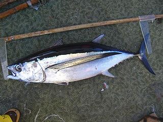
The albacore, known also as the longfin tuna, is a species of tuna of the order Perciformes. It is found in temperate and tropical waters across the globe in the epipelagic and mesopelagic zones. There are six distinct stocks known globally in the Atlantic, Pacific, and Indian oceans, as well as the Mediterranean Sea. The albacore has an elongate, fusiform body with a conical snout, large eyes, and remarkably long pectoral fins. Its body is a deep blue dorsally and shades of silvery white ventrally. Individuals can reach up to 1.4 m in length.

The Atlantic bluefin tuna is a species of tuna in the family Scombridae. It is variously known as the northern bluefin tuna, giant bluefin tuna [for individuals exceeding 150 kg (330 lb)], and formerly as the tunny.
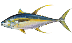
The yellowfin tuna is a species of tuna found in pelagic waters of tropical and subtropical oceans worldwide.

Marine conservation, also known as ocean conservation, is the protection and preservation of ecosystems in oceans and seas through planned management in order to prevent the over-exploitation of these resources. Marine conservation is informed by the study of marine plants and animal resources and ecosystem functions and is driven by response to the manifested negative effects seen in the environment such as species loss, habitat degradation and changes in ecosystem functions and focuses on limiting human-caused damage to marine ecosystems, restoring damaged marine ecosystems, and preserving vulnerable species and ecosystems of the marine life. Marine conservation is a relatively new discipline which has developed as a response to biological issues such as extinction and marine habitats change.

Pelagic fish live in the pelagic zone of ocean or lake waters – being neither close to the bottom nor near the shore – in contrast with demersal fish that do live on or near the bottom, and reef fish that are associated with coral reefs.

The Bigeye tuna is a species of true tuna of the genus Thunnus, belonging to the wider mackerel family Scombridae.

The southern bluefin tuna is a tuna of the family Scombridae found in open southern Hemisphere waters of all the world's oceans mainly between 30°S and 50°S, to nearly 60°S. At up to 2.5 metres (8.2 ft) and weighing up to 260 kilograms (570 lb), it is among the larger bony fishes.

Animal migration tracking is used in wildlife biology, conservation biology, ecology, and wildlife management to study animals' behavior in the wild. One of the first techniques was bird banding, placing passive ID tags on birds legs, to identify the bird in a future catch-and-release. Radio tracking involves attaching a small radio transmitter to the animal and following the signal with a RDF receiver. Sophisticated modern techniques use satellites to track tagged animals, and GPS tags which keep a log of the animal's location. One of the many goals of animal migration research has been to determine where the animals are going; however, researchers also want to know why they are going "there". Researchers not only look at the animals' migration but also what is between the migration endpoints to determine if a species is moving to new locations based on food density, a change in water temperature, or other stimulus, and the animal's ability to adapt to these changes. Migration tracking is a vital tool in efforts to control the impact of human civilization on populations of wild animals, and prevent or mitigate the ongoing extinction of endangered species.
GPS wildlife tracking is a process whereby biologists, scientific researchers or conservation agencies can remotely observe relatively fine-scale movement or migratory patterns in a free-ranging wild animal using the Global Positioning System and optional environmental sensors or automated data-retrieval technologies such as Argos satellite uplink, mobile data telephony or GPRS and a range of analytical software tools.

The Pacific bluefin tuna is a predatory species of tuna found widely in the northern Pacific Ocean, but it is migratory and also recorded as a visitor to the south Pacific.
Natal homing, or natal philopatry, is the homing process by which some adult animals return to their birthplace to reproduce. This process is primarily used by aquatic animals, such as sea turtles and Pacific salmon. Scientists believe that the main cues used by the animals are geomagnetic imprinting and olfactory cues. The benefits of returning to the precise location of an animal's birth may be largely associated with its safety and suitability as a breeding ground. When seabirds, like the Atlantic puffin, return to their natal breeding colony, which are mostly on islands, they are assured of a suitable climate and a sufficient lack of land-based predators.

Geographic Information Systems (GIS) has become an integral part of aquatic science and limnology. Water by its very nature is dynamic. Features associated with water are thus ever-changing. To be able to keep up with these changes, technological advancements have given scientists methods to enhance all aspects of scientific investigation, from satellite tracking of wildlife to computer mapping of habitats. Agencies like the US Geological Survey, US Fish and Wildlife Service as well as other federal and state agencies are utilizing GIS to aid in their conservation efforts.
Tagging of Pacific Predators (TOPP) began in 2000 as one of many projects formed by Census of Marine Life, an organization whose goal is to help understand and explain the diversity and abundances of the ocean in the past, present, and future. After they were formed, TOPP began by building a coalition of researchers from all over the world to find and study predators of the Pacific Ocean. Since then, they have satellite-tagged 22 different species and more than 2,000 animals. These animals include elephant seals, great white sharks, leatherback turtles, squid, albatrosses, and more.
A data storage tag (DST), also sometimes known as an archival tag, is a combination of a data logger and multiple sensors that record data at predetermined intervals. DSTs usually have a large memory size and a long lifetime: most are supported by batteries that allow the tag to record positions for several years. Alternatively some tags are solar powered and allow the scientist to set their own interval; this then allows data to be recorded for significantly longer than battery-only powered tags.
Barbara Block is an American marine biologist and Charles & Elizabeth Prothro Professor of Biology in Marine Sciences at the Stanford University Hopkins Marine Station and a co-director of Stanford University's Tuna Research and Conservation Center, with the Monterey Bay Aquarium. She has published numerous bodies of work throughout her career in marine biology and chemistry, mainly focusing on the biology and chemistry of metabolism in different tuna and shark species. Additionally, she has helped develop two new types of electronic tags for large pelagic predators in order to track the migrations of large oceanic predator species.

A light level geolocator, light-level logger or GLS is essentially a lightweight, electronic archival tracking device, usually used in bird migration research to map migration routes, identify important staging areas, and sometimes provide additional ecological information. A geolocator periodically records ambient light level to determine location.
The history of wildlife tracking technology involves the evolution of technologies that have been used to monitor, track, and locate many different types of wildlife. Many individuals have an interest in tracking wildlife, including biologists, scientific researchers, and conservationists. Biotelemetry is "the instrumental technique for gaining and transmitting information from a living organism and its environment to a remote observer".

Since its inception in the 1960s, wildlife radio telemetry has become a valuable tool to track the movement and behavior of animals. This technique uses the transmission of radio signals to locate a transmitter attached to the animal of interest. It is often used to obtain location data on the animal's preferred habitat, home range, and to understand population dynamics. The different types of radio telemetry techniques include very high frequency (VHF) transmitters, global positioning system (GPS) tracking, and satellite tracking. Recent advances in technology have improved radio telemetry techniques by increasing the efficacy of data collection. However, studies involving radio telemetry should be reviewed in order to determine if newer techniques, such as collars that transmit the location to the operator via satellites, are actually required to accomplish the goals of the study.
ParkinsonSAT, PSat or Naval Academy OSCAR 84, is a U.S. technology demonstration satellite and an amateur radio satellite for Packet Radio. It was built at the U.S. Naval Academy and was planned as a double satellite. The name ParkinsonSAT was chosen in honor of Bradford Parkinson, the father of the GPS system. After successful launch, the satellite was assigned the OSCAR number 84.