
Bay County is a county on the Gulf coast in northwestern Florida. As of the 2010 census, the population was 168,852. Its county seat is Panama City.

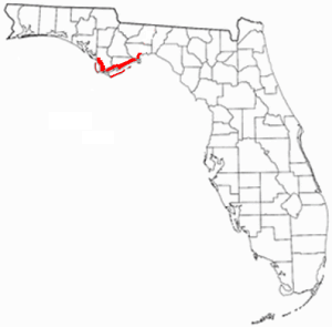
Gulf County is a county located in the panhandle of the U.S. state of Florida. As of the 2010 census, the population was 15,863. Its county seat is Port St. Joe.

Panama City is a city in and the county seat of Bay County, Florida, United States. Located along U.S. Route 98, it is the largest city between Tallahassee and Pensacola. It is the more populated of two principal cities of the Panama City-Lynn Haven, Florida Metropolitan Statistical Area. As of the 2020 census,the population was 32,939. Panama City was catastrophically damaged when Hurricane Michael made landfall as a Category 5 hurricane on October 10, 2018. When Panama City was incorporated in 1909, its original city limits were 15th Street on the north, Balboa Avenue on the west and Bay Avenue on the east.
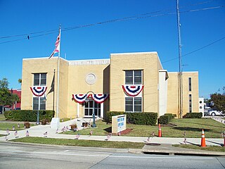
Port St. Joe is a city located at the intersection of U.S. Highway 98 and State Road 71 and the county seat of Gulf County, Florida. As of the 2020 census,the population was 3,357. This was a decline from 3,644 as of the 2000 census.
Panama City–Bay County International Airport was a public airport 3 miles (4.8 km) northwest of Panama City, in Bay County, Florida. It was owned and operated by the Panama City–Bay County Airport and Industrial District. All airline services moved to the Northwest Florida Beaches International Airport on May 22, 2010, but the airfield was open to general aviation aircraft until October 1, 2010. The grounds will eventually be turned over to LUK-MB1 LLC, which plans to remove the runways and build homes, shops, walking trails and a marina.

UTC−05:00 is an identifier for a time offset from UTC of −05:00. In North America, it is observed in the Eastern Time Zone during standard time, and in the Central Time Zone during the other eight months. The western Caribbean uses it year round.

The Thumb is a region and a peninsula of the U.S. state of Michigan, so named because the Lower Peninsula is shaped like a mitten. The Thumb area is generally considered to be in the Central Michigan region, east of the Tri-Cities and north of Metro Detroit. The region is also branded as the Blue Water Area.

The Florida Panhandle is the northwestern part of the U.S. state of Florida; it is a strip of land roughly 200 miles (320 km) long and 50 to 100 miles wide, lying between Alabama on the north and the west, Georgia on the north, and the Gulf of Mexico to the south. Its eastern boundary is arbitrarily defined. In terms of population, major communities include Tallahassee, Pensacola, and Navarre.
State Road 30A (SR 30A) is a Florida Department of Transportation designation shared by four alternate routings of SR 30 in the Florida panhandle. Two segments have SR 30A signage; the other two do not as they are segments of U.S. Route 98 (US 98). Three of the four SR 30A segments are next to the shore of the Gulf of Mexico for most of their length.

State Road 30 is the mostly hidden Florida Department of Transportation designation for most of US 98 from the Florida-Alabama state line to east of Perry, Florida.

St. Joseph Bay is a bay on the Gulf Coast of the U.S. state of Florida. The bay is located in Gulf County between Apalachicola and Panama City. Port St. Joe is located on St. Joseph Bay.
Florida's Forgotten Coast is a registered trademark coined in the early 1990s by the Apalachicola Bay Chamber of Commerce. The name is most commonly used to refer to a relatively quiet, undeveloped and largely uninhabited section of coastline stretching from Mexico Beach on the Gulf of Mexico to St. Marks on Apalachee Bay in the U.S. state of Florida. The nearest major cities are Tallahassee, about 90 miles (145 km) northeast of Apalachicola, and Panama City, home of Tyndall Air Force Base, about 60 miles (95 km) to the northwest.

Governor Stone is a historic schooner, built in 1877, in Pascagoula, Mississippi. She is the only surviving two-masted coasting cargo schooner built on the Gulf Coast of the United States, and is only one of five such surviving US-built ships. On 4 December 1991, she was added to the US National Register of Historic Places. One year later, the schooner was designated a US National Historic Landmark. She is presently berthed at Saint Andrews Marina in Panama City, Florida, where she is maintained by a nonprofit group. Sailing tours are regularly scheduled.
The News Herald is a daily newspaper serving the city of Panama City, Florida in the United States. It is located at 501 W. 11th St. in Panama City.

Naval Support Activity Panama City, is a military shore installation of the United States Navy located in Bay County, just outside Panama City, Florida. Among its various tenant commands, it houses the Naval Surface Warfare Center Panama City Division, the Center for Explosive Ordnance Disposal & Diving (CENEODDIVE), the Navy Experimental Diving Unit (NEDU), and Coast Guard Station Panama City.

USS Walworth County (LST-1164), previously USS LST-1164, was a United States Navy landing ship tank (LST) in commission from 1953 to 1971, and which then saw non-commissioned Military Sealift Command service as USNS Walworth County (T-LST-1164) from 1972 to 1973.
State Road 368 (SR 368) is a short state road an east–west "bypass route", locally known as 23rd Street, in and around the vicinity of Panama City, Florida. The road is entirely four-lanes wide with center left-turn lanes where available, and is divided only at its eastern terminus. No roads overlap SR 368 or vice versa.

