
Jacksonville is the most populous city in Florida, and is the largest city by area in the contiguous United States as of 2020. It is the seat of Duval County, with which the city government consolidated in 1968. Consolidation gave Jacksonville its great size and placed most of its metropolitan population within the city limits. As of 2020, Jacksonville's population is 949,611, making it the 13th most populous city in the U.S., the most populous city in the Southeast, and the most populous city in the South outside of the state of Texas. The Jacksonville metropolitan area has a population of 1,523,615 and is the fourth largest metropolitan area in Florida.

St. Augustine is a city in the Southeastern United States, on the Atlantic coast of northeastern Florida. Founded in 1565 by Spanish explorers, it is the oldest continuously-inhabited European-established settlement in the contiguous United States.
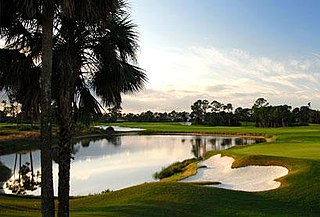
Port St. Lucie is a city in St. Lucie County, Florida, United States. It is the most populous municipality in the county with a population of 164,603 at the 2010 census due to its rapid growth during the 2000s. It is located 125 miles (201 km) southeast of Orlando and 113 miles (182 km) north of Miami. In 2019, the United States Census Bureau estimated the city's population at 201,846. The Port St. Lucie Metropolitan Area includes the counties of St. Lucie and Martin and as of 2016 had an estimated population of 465,208. Port St. Lucie is also contained within the Miami - Fort Lauderdale - Port St. Lucie Combined Statistical Area with an estimated population of 6,832,588.

New Smyrna Beach is a city in Volusia County, Florida, United States, located on the central east coast of the state, with the Atlantic Ocean to the east. Its population is 30,142 in 2020 by the United States Census Bureau. The downtown section of the city is located on the west side of the Indian River and the Indian River Lagoon system. The Coronado Beach Bridge crosses the Intracoastal Waterway just south of Ponce de Leon Inlet, connecting the mainland with the beach on the coastal barrier island.
The history of Florida can be traced to when the first Native Americans began to inhabit the peninsula as early as 14,000 years ago. They left behind artifacts and archeological evidence. Florida's written history begins with the arrival of Europeans; the Spanish explorer Juan Ponce de León in 1513 made the first textual records. The state received its name from that conquistador, who called the peninsula La Pascua Florida in recognition of the verdant landscape and because it was the Easter season, which the Spaniards called Pascua Florida.

East Florida was a colony of Great Britain from 1763 to 1783 and a province of Spanish Florida from 1783 to 1821. Great Britain gained control of the long-established Spanish colony of La Florida in 1763 as part of the treaty ending the French and Indian War. Deciding that the territory was too large to administer as a single unit, Britain divided Florida into two colonies separated by the Apalachicola River: East Florida with its capital in St. Augustine and West Florida with its capital in Pensacola. East Florida was much larger and comprised the bulk of the former Spanish territory of Florida and most of the current state of Florida. However, most of the Spanish population, including all of St Augustine emigrated after the treaty.

The Castillo de San Marcos is the oldest masonry fort in the continental United States; it is located on the western shore of Matanzas Bay in the city of St. Augustine, Florida.

Spanish Florida was the first major European land claim and attempted settlement in North America during the European Age of Discovery. La Florida formed part of the Captaincy General of Cuba, the Viceroyalty of New Spain, and the Spanish Empire during Spanish colonization of the Americas. While its boundaries were never clearly or formally defined, the territory was initially much larger than the present-day state of Florida, extending over much of what is now the southeastern United States, including all of present-day Florida plus portions of Georgia, Alabama, Mississippi, North Carolina, South Carolina, and Louisiana. Spain's claim to this vast area was based on several wide-ranging expeditions mounted during the 16th century. A number of missions, settlements, and small forts existed in the 16th and to a lesser extent in the 17th century; they were eventually abandoned due to pressure from the expanding English and French colonial settlements, the collapse of the native populations, and the general difficulty in becoming agriculturally or economically self-sufficient. By the 18th century, Spain's control over La Florida did not extend much beyond a handful of forts near St. Augustine, St. Marks, and Pensacola, all within the boundaries of present-day Florida.

The Halifax River is part of the Atlantic Intracoastal Waterway, located in northeast Volusia County, Florida. The waterway was originally known as the North Mosquito River, but was renamed after George Montagu-Dunk, 2nd Earl of Halifax, during the British occupation of Florida (1763–1784).
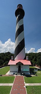
The St. Augustine Light Station is a private-aid to navigation and an active, working lighthouse in St. Augustine, Florida. The current lighthouse stands at the north end of Anastasia Island and was built between 1871 and 1874. The tower is the second lighthouse tower in St. Augustine, the first being lit officially by the American territorial government in May 1824 as Florida's first lighthouse. However, both the Spanish and the British governments operated a major aid to navigation here including a series of wooden watch towers and beacons dating from 1565.
The Battle of Thomas Creek, or the Thomas Creek Massacre, was an ambush of a small force of Georgia militia cavalry by a mixed force of British Army, Loyalist militia, and Indians near the mouth of Thomas Creek in northern East Florida. The encounter was the only major engagement in the second of three failed attempts by American forces to invade East Florida in the early years of the American Revolutionary War.

Fort Mose Historic State Park is a U.S. National Historic Landmark, located two miles north of St. Augustine, Florida, on the edge of a salt marsh on the western side of the waterway separating the mainland from the coastal barrier islands. The original site of the 18th-century fort was uncovered in a 1986 archeological dig. The 24-acre (9.7 ha) site is now protected as a Florida State Park, administered through the Anastasia State Recreation Area. Fort Mose is the "premier site on the Florida Black Heritage Trail". In 1738, the Spanish governor of Florida, Manuel de Montiano, had Fort Mose constructed and established it as a free black settlement, the first to be legally sanctioned in what would become the territory of the United States. The fort has also been called Fort Moosa or Fort Mossa, variants of the Spanish pronunciation.
Melchor Feliú (?-1766) was the last governor in the First Spanish Period of Florida's history, governing from March 20, 1762 to July 27, 1763. Feliú oversaw the cession of Florida to Great Britain by the Treaty of Paris on July 21, 1763 and the subsequent immigration of most of the province's Spanish and African inhabitants to Cuba. Some of the Native Americans living in the Spanish Catholic missions also moved away from Florida at this time.
The Jacksonville Jaguars Radio Network is an 19-station radio network based in the southeastern United States & is based in Jacksonville, Florida. Beginning with the 2014 season, the network originates at WJXL & WJXL-FM in Jacksonville Beach, Florida as well as WGNE-FM in Middleburg, Florida. Network programming consists of Jacksonville Jaguars pre-season, regular season & post-season games as well as a coach's show.
The Port of Fernandina is located on Florida's Atlantic coast. It is used for terminal service for pulp and paper as well as steel exports, machinery, auto parts, chemicals, beverages, chemicals, building materials and food products. Container lines from the port serve routes to Colombia, Venezuela, the Dominican Republic, Haiti, Jamaica, Aruba, Curaçao and Bermuda.
Francisco del Moral Sánchez Villegas was the governor of Spanish Florida from mid-1734 to early 1737.

The history of slavery in Florida predates the period of European colonization and was practiced by various indigenous peoples. Few enslaved Africans were imported into Florida from Cuba in the period of Spanish colonial rule. Starting in 1687, slaves escaping from English colonies to the north were freed when they accepted Catholicism. Black slavery in the region was reestablished after Florida came under British then American control. Slavery in Florida was theoretically abolished by the 1863 Emancipation Proclamation issued by President Lincoln, though as the state was part of the Confederacy this had little effect.
The history of St. Augustine, Florida, the oldest continuously occupied settlement of European origin in the continental United States, began in 1565 when it was founded by the Spanish admiral, Pedro Menéndez de Avilés. The Spanish Crown issued an asiento to Menéndez, signed by King Philip II on March 20, 1565, granting him various titles, including that of adelantado of Florida, and expansive privileges to exploit the lands in the vast territory of Spanish Florida, called La Florida by the Spaniards. This contract directed Menéndez to explore the region's Atlantic coast and report on its features, with the object of finding a suitable location to establish a permanent colony from which the Spanish treasure fleet could be defended and Spain's claimed territories in North America protected against incursions by other European powers.
The Prince of Wales' American Regiment was a volunteer regiment of Loyalists in the American Revolution organized in 1776 and 1777 by Montfort Browne, former governor of the Bahamas. Recruits were largely from among Connecticut Loyalists.
The King's Carolina Rangers (KCR) was a loyalist militia regiment active during the American War of Independence. The KCR was composed of nine infantry companies, of which one was converted into a troop of dragoons in 1782. The unit primarily saw action in the South Carolina and Georgia theatres of the conflict.

