Port St. Joe, Florida

Last updated

Port St. Joe, Florida
City of Port St. Joe
PSJ FL city hall02.jpg
Port St. Joe City Hall
Nickname: 
St. Joe
Motto(s): 
"The Constitution City"
"Birthplace of the Florida Constitution"
"In God We Trust"
Gulf County Florida Incorporated and Unincorporated areas Port St. Joe Highlighted.svg
Location in Gulf County and the state of Florida
Coordinates: 29°48′53″N85°17′50″W / 29.81472°N 85.29722°W / 29.81472; -85.29722
Country Flag of the United States.svg United States
State Flag of Florida.svg  Florida
County   Gulf
Settled 1835-1862
Incorporated 1913 [1]
Named for St. Joseph Bay
Government
  Type Commission–Manager
   Mayor Rex Buzzett
   Commissioners Scott Hoffman, Brett Lowry,
Steve Kerigan, and
Eric Langston
   City Manager Jim Anderson
   City Clerk Charlotte Pierce
Area
[2]
  Total11.97 sq mi (30.99 km2)
  Land9.37 sq mi (24.26 km2)
  Water2.60 sq mi (6.73 km2)
Elevation
2 ft (0.6 m)
Population
 (2020)
  Total3,357
  Density358.39/sq mi (138.38/km2)
Time zone UTC−5 (Eastern (EST))
  Summer (DST) UTC−4 (EDT)
ZIP codes
32456, 32457
Area code 850
FIPS code 12-58675
GNIS feature ID2404557 [3]
Website www.cityofportstjoe.com

Port St. Joe is a city and the county seat of Gulf County, Florida. It is located at the intersection of U.S. Highway 98 and State Road 71. As of the 2020 census, the population was 3,357.

Contents

History

Port St. Joe, 1943 Florida - Port St. Joe - NARA - 23936813 (cropped).jpg
Port St. Joe, 1943

St. Joseph was founded in 1835 by businessmen from nearby Apalachicola, which was troubled by legal conflict over land titles. [4] It was mostly abandoned in 1841, after a yellow fever epidemic; a storm surge produced by a hurricane in 1844 destroyed what structures remained. [5]

During the Civil War, Florida was a leading producer of salt for the Confederate army. On September 15, 1862, a Union army officer on board the USS Kingfisher wrote that he and his men had sent a demand to the extensive salt works at Saint Joseph that they cease production. When the work was not halted, the Kingfisher went into Saint Joseph bay, sent at least 50 men inland, and destroyed the salt works. [6]

In the early 20th century, a new settlement was founded close to the original after the arrival of the Apalachicola Northern Railroad in 1909. It appears that the more informal "Port St. Joe" was adopted for official use around this time.

The community was extensively damaged by Hurricane Michael on October 10, 2018. [7]

Geography

Cape San Blas Light Cape San Blas Light.jpg
Cape San Blas Light

Port St. Joe is located in southern Gulf County at 29°48′29″N85°17′52″W / 29.80806°N 85.29778°W / 29.80806; -85.29778 (29.807968, –85.297684), [8] within the Florida Panhandle and along the Emerald Coast. According to the United States Census Bureau, the city has a total area of 12.1 square miles (31.3 km2), of which 9.5 square miles (24.5 km2) is land and 2.6 square miles (6.8 km2), or 21.86%, is water. The city limits extend into St. Joseph Bay, an arm of the Gulf of Mexico.

U.S. Route 98 passes through Port St. Joe as Monument Drive in the north and Constitution Drive in the south. US 98 leads northwest along the Gulf shore 36 miles (58 km) to Panama City and southeast 23 miles (37 km) to Apalachicola. Florida State Road 71 (Cecil G. Costin Sr. Boulevard) leads northeast 24 miles (39 km) to Wewahitchka.

Port St. Joe averages only 3 feet (0.91 m) above sea level. At its highest point it is only 8 feet (2.4 m) above sea level. This portion of the town has been dubbed "Highland View".

Climate

The City of Port St. Joe is part of the humid subtropical climate zone with a Köppen Climate Classification of "Cfa" (C = mild temperate, f = fully humid, and a = hot summer).

Demographics

Historical population
CensusPop.Note
1930 851
1940 2,393181.2%
1950 2,75215.0%
1960 4,21753.2%
1970 4,4014.4%
1980 4,027−8.5%
1990 4,0440.4%
2000 3,644−9.9%
2010 3,445−5.5%
2020 3,357−2.6%
U.S. Decennial Census [9]

2010 and 2020 census

Port St. Joe racial composition
(Hispanics excluded from racial categories)
(NH = Non-Hispanic)
RacePop 2010 [10] Pop 2020 [11] % 2010% 2020
White (NH)2,4082,21069.90%65.83%
Black or African American (NH)87978125.52%23.26%
Native American or Alaska Native (NH)10140.29%0.42%
Asian (NH)12250.35%0.74%
Pacific Islander or Native Hawaiian (NH)100.03%0.00%
Some other race (NH)1110.03%0.33%
Two or more races/Multiracial (NH)441451.28%4.32%
Hispanic or Latino (any race)901712.61%5.09%
Total3,4453,357

As of the 2020 United States census, there were 3,357 people, 1,494 households, and 999 families residing in the city. [12]

As of the 2010 United States census, there were 3,445 people, 1,544 households, and 946 families residing in the city. [13]

2000 census

As of the census [14] of 2000, there were 3,644 people, 1,402 households, and 1,030 families residing in the city. The population density was 1,097.4 inhabitants per square mile (423.7/km2). There were 1,571 housing units at an average density of 473.1 per square mile (182.7/km2). The racial makeup of the city was 68.52% White, 30.10% African American, 0.22% Native American, 0.22% Asian, 0.05% from other races, and 0.88% from two or more races. Hispanic or Latino of any race were 0.55% of the population.

In 2000, there were 1,402 households, out of which 28.8% had children under the age of 18 living with them, 54.2% were married couples living together, 14.8% had a female householder with no husband present, and 26.5% were non-families. 24.9% of all households were made up of individuals, and 14.0% had someone living alone who was 65 years of age or older. The average household size was 2.48 and the average family size was 2.94.

In 2000, in the city, the population was spread out, with 23.6% under the age of 18, 6.7% from 18 to 24, 24.6% from 25 to 44, 23.6% from 45 to 64, and 21.5% who were 65 years of age or older. The median age was 42 years. For every 100 females, there were 88.4 males. For every 100 females age 18 and over, there were 80.7 males.

In 2000, the median income for a household in the city was $33,800, and the median income for a family was $39,489. Males had a median income of $30,244 versus $21,111 for females. The per capita income for the city was $16,205. About 11.2% of families and 13.0% of the population were below the poverty line, including 16.2% of those under age 18 and 11.7% of those age 65 or over.

Schools and libraries

Port St. Joe, within Gulf District Schools, has one elementary school, with Dolphins as mascot. It has a joint middle-high school, Port St. Joe High School, with Sharks as the mascot. The school colors are purple and gold. There is also a small private school, Faith Christian School, which has the lions as its mascot. All of the public schools are located on one development strip set aside under the Department of Education. This begins with the elementary school and its playground and continues with the football stadium, a quarter mile running track, and finally the high school and adult school stretching a distance of about 5 city blocks. Port St. Joe also has a community college that offers two year associate degrees.

Port St. Joe has a library co-located with the senior citizens center, sheriff's office, courthouse, and animal shelter off State Road 71.

The Florida Constitutional Convention of 1838 took place in the former town of St. Joseph, the site of which is now part of Port St. Joe. There is a museum and monument commemorating this event.

Local media

Port Theatre Porttheatreportstjoe.jpg
Port Theatre

Radio

Newspaper

Transportation

Port St. Joe is served by a variety of transportation modes.

Water

St. Joseph Catholic Mission Church Cathchurchportstjoe.jpg
St. Joseph Catholic Mission Church

Port St. Joe is traversed by the Gulf Intracoastal Waterway (GIWW), a federally maintained canal with a channel of 12 feet (3.7 m) deep by 125 feet (38 m) wide, which provides access from St. Marks, Florida, to Brownsville, Texas. From the GIWW, barges can be moved inland on various river systems including the Mississippi River, Tombigbee River Waterway System, and the Apalachicola River. The Apalachicola River is Gulf County's eastern boundary.

The Port of Port St. Joe shipping channel is congressionally authorized to a depth of 35 feet (11 m) and connects to the shipping lanes of the Gulf of Mexico and to the world. Existing facilities include a manufacturer of chemical lime from dolomite, a chemical plant, a 9 million ton/year dry bulk barge-to-rail transloading terminal, and a builder of dive-cruise ships.

Rail

The AN Railway previously served the industries and port of Port St. Joe and had a history of transporting a variety of products including wood chips and other forest products, chemicals, and coal. In light of the latter, most of its 96-mile (154 km) mainline consisted of heavy duty, 140-pound (64 kg) rail on concrete ties. The AN connected with the Class I CSX Transportation at Chattahoochee, Florida. There is currently no rail service in Port St. Joe.[ citation needed ]

Highway

Gulf County's highway transportation needs are met with three main corridors: U.S. Route 98 along the coast and through Port St. Joe providing a route west to Panama City and east to Apalachicola, State Road 22 westward from Wewahitchka to Panama City, and State Road 71 from Port St. Joe northward toward Alabama and Georgia. Further, State Road 71 provides a low-traffic connection to Interstate 10, with only two traffic signals between Port St. Joe and Interstate 10 over the 72-mile (116 km) distance.

Notable people

See also

Related Research Articles

<span class="mw-page-title-main">Bay County, Florida</span> County in Florida, United States

Bay County is a county on the Emerald Coast in Northwest Florida. As of the 2020 census, the population was 175,216. Its county seat is Panama City.

<span class="mw-page-title-main">Calhoun County, Florida</span> County in Florida, United States

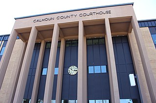
Calhoun County is a county located in the U.S. state of Florida. As of the 2020 census, the population was 13,648, making it the fifth-least populous county in Florida. Its county seat is Blountstown.

<span class="mw-page-title-main">Franklin County, Florida</span> County in Florida, United States

Franklin County is a county along the Gulf of Mexico in the panhandle of the U.S. state of Florida. As of the 2020 census, the population was 12,451, making it the third-least populous county in Florida. The county seat is Apalachicola.

<span class="mw-page-title-main">Gadsden County, Florida</span> County in Florida, United States

Gadsden County is a county located in the panhandle of the U.S. state of Florida. As of the 2020 census, the population was 43,826. Its county seat is Quincy. Gadsden County is included in the Tallahassee, FL Metropolitan Statistical Area. Gadsden County is the only majority African-American county in Florida.

<span class="mw-page-title-main">Gulf County, Florida</span> County in Florida, United States

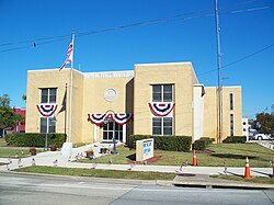
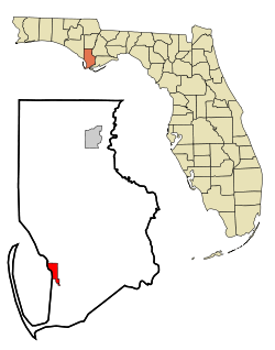
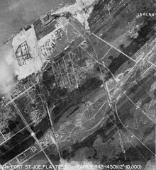
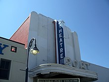
Gulf County is a county located in the panhandle of the U.S. state of Florida. As of the 2020 census, the population was 14,192. Its county seat is Port St. Joe.

<span class="mw-page-title-main">Holmes County, Florida</span> County in Florida, United States

Holmes County is a county located in the northwestern part of the U.S. state of Florida, in the Panhandle. As of the 2020 census, the population was 19,653. Its county seat is Bonifay.

<span class="mw-page-title-main">Liberty County, Florida</span> County in Florida, United States

Liberty County is a county located in the state of Florida. As of the 2020 census, the population was 7,974, making it the least populous county in Florida. Its county seat is Bristol. Liberty County is one of only two dry counties in Florida.

<span class="mw-page-title-main">Mexico Beach, Florida</span> City in Florida, United States

Mexico Beach is a city in Bay County, Florida, United States. It is located 25 miles (40 km) southeast of Panama City. It is part of the Panama City-Panama City Beach, Florida Metropolitan Statistical Area. The population was 916 at the 2020 census.

<span class="mw-page-title-main">Panama City, Florida</span> City in the United States

Panama City is a city in the county seat of Bay County, Florida, United States. Located along U.S. Highway 98 (US 98), it is the largest city between Tallahassee and Pensacola. It is also the most populated city of the Panama City–Lynn Haven, Florida metropolitan statistical area. Panama City was severely damaged when Hurricane Michael made landfall as a Category 5 hurricane on October 10, 2018. As of the 2020 census, the population was 32,939, down from the figure of 36,484 at the 2010 census.

Parker is a city in Bay County, Florida, United States. It is part of the Panama City–Lynn Haven–Panama City Beach Metropolitan Statistical Area. As of the 2020 US census, it had a population of 4,010.

<span class="mw-page-title-main">Apalachicola, Florida</span> City in Florida, United States of America

Apalachicola is a city and the county seat of Franklin County, Florida, United States, on the shore of Apalachicola Bay, an inlet of the Gulf of Mexico. The population was 2,341 at the 2020 census.

<span class="mw-page-title-main">Carrabelle, Florida</span> City in Florida, United States

Carrabelle is a city in Franklin County along Florida's Panhandle, United States. It is located east of Apalachicola at the mouth of the Carrabelle River on the Gulf of Mexico. The population was 2,606 as of the 2020 census.

<span class="mw-page-title-main">Wewahitchka, Florida</span> City in Florida, United States

Wewahitchka is a city in Gulf County, Florida, United States. The population was 2,074 as of the 2020 census. From the creation of Gulf County in 1925 until 1965, it served as the county seat before the county seat was moved to Port St. Joe. The city took its name from a Native American word meaning "water eyes". Two lakes along the edge of town look like a perfect pair of eyes.

<span class="mw-page-title-main">Bristol, Florida</span> City in Florida, United States

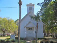
Bristol is a city in and the county seat of Liberty County, Florida, United States. It is the only incorporated city in Liberty County. The population was 918 at the 2020 census.

<span class="mw-page-title-main">Destin, Florida</span> City in Florida, United States of America

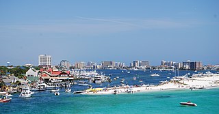
Destin is a city located in Okaloosa County, Florida, United States. It is a principal city of the Crestview–Fort Walton Beach–Destin metropolitan area.

<span class="mw-page-title-main">New Port Richey, Florida</span> City in Pasco County, Florida, United States

New Port Richey is a city in Pasco County, Florida, United States. It is a suburban city included in the Tampa-St. Petersburg-Clearwater, Florida Metropolitan Statistical Area. The population was counted at 16,728 in the 2020 census.

<span class="mw-page-title-main">Madeira Beach, Florida</span> City in Florida, United States

Madeira Beach is a city in Pinellas County, Florida, United States, bordered on the west by the Gulf of Mexico, and on the east by St. Petersburg. As of the 2020 census, the population was 3,895. The entertainment district of John's Pass is located on the Intracoastal Waterway. The city is often referred to by locals as Mad Beach. It is named after the Portuguese island of Madeira.

<span class="mw-page-title-main">St. Pete Beach, Florida</span> City in Florida, United States

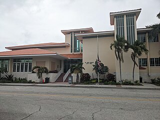
St. Pete Beach is a coastal city in Pinellas County, Florida. Known as a tourist destination, St. Pete Beach was formed from the towns of Pass-a-Grille, Belle Vista, St. Petersburg Beach, and unincorporated Pinellas County. It is part of the Tampa Bay area. The population was 8,879 at the 2020 census.

<span class="mw-page-title-main">Gulf Breeze, Florida</span> City in Florida, United States

Gulf Breeze is a city in Santa Rosa County, Florida. It is a suburb of Pensacola, and is in the Pensacola Metropolitan Area. The population was 6,302 in 2020.

<span class="mw-page-title-main">St. Marks, Florida</span> City in Florida, United States

St. Marks is a city in Wakulla County, Florida, United States. It is part of the Tallahassee metropolitan area. The population was 293 at the 2010 census. As of 2018, the population estimated by the U.S. Census Bureau is 319.

References

  1. "FLORIDA CITIES BY INCORPORATION YEAR" (PDF). Florida League of Cities. Retrieved January 1, 2024.
  2. "2020 U.S. Gazetteer Files". United States Census Bureau. Retrieved October 31, 2021.
  3. "US Board on Geographic Names". United States Geological Survey. October 25, 2007. Retrieved January 31, 2008.
  4. Cox, Dale. "St. Joseph - Florida's Lost City - The Story of the City on St. Joseph Bay". Explore Southern History. Archived from the original on July 4, 2008.
  5. Jones, Herman (September 8, 2016). "Death's Angel: The 'Great Tide' of 1844". The (Port St. Joe) Star. Archived from the original on October 13, 2018. Retrieved October 12, 2018.
  6. "Destruction of a Rebel Salt Factory, on the Florida Coast". Florida Memory.
  7. Banerjee, Neela (November 25, 2019). "The Common Language of Loss". InsideClimate News . Retrieved December 8, 2019.
  8. "US Gazetteer files: 2010, 2000, and 1990". United States Census Bureau. February 12, 2011. Retrieved April 23, 2011.
  9. "Census of Population and Housing". Census.gov. Retrieved June 4, 2015.
  10. "P2 HISPANIC OR LATINO, AND NOT HISPANIC OR LATINO BY RACE - 2010: DEC Redistricting Data (PL 94-171) - Port St. Joe city, Florida". United States Census Bureau .
  11. "P2 HISPANIC OR LATINO, AND NOT HISPANIC OR LATINO BY RACE - 2020: DEC Redistricting Data (PL 94-171) - Port St. Joe city, Florida". United States Census Bureau .
  12. "S1101 HOUSEHOLDS AND FAMILIES - 2020: Port St. Joe city, Florida". United States Census Bureau .
  13. "S1101 HOUSEHOLDS AND FAMILIES - 2010: Port St. Joe city, Florida". United States Census Bureau .
  14. "U.S. Census website". United States Census Bureau . Retrieved January 31, 2008.