
According to Article 168 [1] of the Constitution of Costa Rica , the political divisions are officially classified into 3 tiers of sub-national entities.
According to Article 168 [1] of the Constitution of Costa Rica , the political divisions are officially classified into 3 tiers of sub-national entities.
The Constitution of Costa Rica states, "For Public Administration purposes, the national territory is divided into provinces, these into cantons and cantons into districts." The country consists of 7 provinces (provincias), 84 cantons (cantones), and 489 districts (distritos). [2]
| Flag | Province | Map | Capital | Area (km2) | Population | Density (km2) | Human Development Index 2015 [3] | GDP per capita 2023 (PPP 2015 dollar) [4] |
|---|---|---|---|---|---|---|---|---|
| | Alajuela |  | Alajuela | 9,757 | 885,571 | 90.8 | 0.778 | 19,100 |
| | Cartago |  | Cartago | 3,124 | 490,903 | 156.2 | 0.786 | 20,000 |
| | Guanacaste |  | Liberia | 10,141 | 354,154 | 34.9 | 0.755 | 17,500 |
| | Heredia |  | Heredia | 2,657 | 433,677 | 163.2 | 0.807 | 19,900 |
| | Limón |  | Puerto Limón | 9,189 | 386,862 | 42.1 | 0.735 | 16,300 |
| | Puntarenas |  | Puntarenas | 11,266 | 410,929 | 36.5 | 0.741 | 17,400 |
| | San José |  | San José | 4,966 | 1,404,242 | 282.8 | 0.792 | 19,800 |
 |
|---|
Cartago, which means Carthage in Spanish, is a province of central Costa Rica. It is one of the smallest provinces, however probably the richest of the Spanish Colonial era sites and traditions.

Guanacaste is a province of Costa Rica located in the northwestern region of the country, along the coast of the Pacific Ocean. It is bordered by Nicaragua to the north, Alajuela Province to the east, and Puntarenas Province to the southeast. It is the most sparsely populated of all the provinces of Costa Rica. The province covers an area of 10,141 square kilometres (3,915 sq mi) and as of 2010, had a population of 354,154, with annual revenue of $2 billion.

Heredia is a province of Costa Rica. It is in the north-central part of the country. As a result, the province covers areas as diverse as the agriculture-rich Northern plains to the more metropolitan areas such as the city of Heredia in the Central Valley. It contains several major environmentally important areas such as the Braulio Carrillo National Park and the Sarapiqui River. The capital is the city of Heredia.

Limón is one of seven provinces in Costa Rica. The province covers an area of 9,189 km2, and has a population of 386,862.
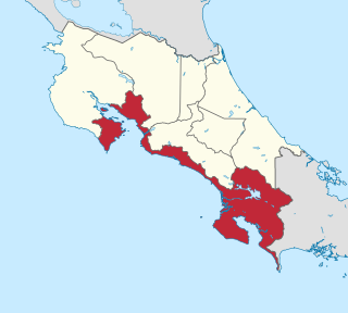
Puntarenas is a province of Costa Rica. It is located in the western part of the country, covering most of Costa Rica's Pacific Ocean coast, and it is the largest province in Costa Rica. Clockwise from the northwest it borders on the provinces Guanacaste, Alajuela, San José and Limón, and the neighbouring country of Panama.

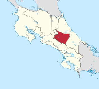
San José is a province of Costa Rica. It is located in the central part of the country, and borders the provinces of Alajuela, Heredia, Limón, Cartago and Puntarenas. The provincial and national capital is San José. The province covers an area of 4,965.9 km². and has a population of 1,404,242.

Bocas del Toro (Spanish pronunciation:[ˈbokasðelˈtoɾo]; meaning "Mouths of the Bull") is a province of Panama. Its area is 4,643.9 square kilometers, comprising the mainland and nine main islands. The province consists of the Bocas del Toro Archipelago, Bahía Almirante, Chiriquí Lagoon, and adjacent mainland. The capital is the city of Bocas del Toro on Isla Colón. Other major cities or towns include Almirante and Changuinola. The province has a population of 159,228 as of 2023.

The La Paz Department of Bolivia comprises 133,985 square kilometres (51,732 sq mi) with a 2012 census population of 2,706,359 inhabitants. It is situated at the western border of Bolivia, sharing Lake Titicaca with the neighboring Peru. It contains the Cordillera Real mountain range, which reaches altitudes of 6.6 kilometers (22,000 ft). Northeast of the Cordillera Real are the Yungas, the steep eastern slopes of the Andes Mountains that make the transition to the Amazon River basin to the northeast. The capital of the department is the city of La Paz and is the administrative city and seat of government/national capital of Bolivia.

Costa Rica is administratively divided into seven provinces which are subdivided into 84 cantons, and these are further subdivided into districts. Cantons are the only administrative division in Costa Rica that possess local government in the form of municipalities. Each municipality has its own mayor and several representatives, all of them chosen via municipal elections every four years.

Montes de Oca is a canton in the San José province of Costa Rica. The head city of the canton is San Pedro.

Heredia is a district in the Heredia canton of Heredia province, Costa Rica. As the seat of the municipality of Heredia canton, it is awarded the status of city, and by virtue of being the city of the first canton, it is the Province Capital of Heredia province as well. It is 10 kilometers to the north of the country's capital, San José.
According to the Political Constitution of Costa Rica of 1949, in article 168, the territorial division of Costa Rica is organized by law into three types of subnational entity:
San Vito, originally named San Vito de Java, is a district and head city of the Coto Brus canton, in the Puntarenas province of Costa Rica. It is located about 271 kilometres (168 mi) southeast of the capital San José, and close to the Panama border.
Costa Rica’s municipal system is organized under the Municipal Code, the specific law that regulates the local governments. Municipalities are the second-level administration in Costa Rica after the central government. Each one of the 82 cantons of Costa Rica has a Municipality or Municipal Government constituted by a mayor and a proportional number of members of the Municipal Council. Districts of each of the cantons also have their local authorities and representatives. Some of the services manage by local governments include; solid waste management, building and administration of local roads, parks, libraries and schools, recollection of municipal taxes and in some cases local security. Worth noticing that in Costa Rica city and municipality are not the same thing, as a canton can have several cities within its borders, generally as districts.
According to the Territorial Administrative Division, the cantons of Costa Rica are subdivided into 492 districts (distritos), each of which has a unique five-digit postal code.
Santa María is a district of the Dota canton, in the San José province of Costa Rica.
National Primary Route 10, or just Route 10 is a National Road Route of Costa Rica, located in the Cartago, Limón provinces.
National Secondary Route 119, or just Route 119 is a National Road Route of Costa Rica, located in the Alajuela, Heredia provinces.
National Secondary Route 120, or just Route 120 is a National Road Route of Costa Rica, located in the Alajuela, Heredia provinces.
![]() Media related to Provinces of Costa Rica at Wikimedia Commons
Media related to Provinces of Costa Rica at Wikimedia Commons
| | This Costa Rican location article is a stub. You can help Wikipedia by expanding it. |