History
Sebewaing's name was derived from the Algonquian language of Native Americans, the original inhabitants of the area. The village was founded in 1845 by Rev. John J.F. Auch, a Lutheran minister sent by the church to do missionary work in the Native American communities. [5]
Beginning in the mid-19th century, the town was settled by many migrants of German ancestry. In 1880 the E.O. Braendle Brewery began operations. The brewing operation was forced to close during Prohibition, but in 1927 it was renamed, and the Sebewaing Brewing Company brewed many types of German-style beer in the town until 1965. [6] [7] [8] The defunct Michigan Brewing company in Webberville, Michigan resurrected some of the brands, using authentic formulae and labels. [9]
Demographics
Historical population| Census | Pop. | Note | %± |
|---|
| 1880 | 553 | | — |
|---|
| 1890 | 719 | | 30.0% |
|---|
| 1900 | 1,243 | | 72.9% |
|---|
| 1910 | 1,347 | | 8.4% |
|---|
| 1920 | 1,446 | | 7.3% |
|---|
| 1930 | 1,441 | | −0.3% |
|---|
| 1940 | 1,598 | | 10.9% |
|---|
| 1950 | 1,911 | | 19.6% |
|---|
| 1960 | 2,026 | | 6.0% |
|---|
| 1970 | 2,053 | | 1.3% |
|---|
| 1980 | 2,046 | | −0.3% |
|---|
| 1990 | 1,923 | | −6.0% |
|---|
| 2000 | 1,974 | | 2.7% |
|---|
| 2010 | 1,759 | | −10.9% |
|---|
| 2020 | 1,721 | | −2.2% |
|---|
|
2010 census
As of the census [11] of 2010, there were 1,759 people, 802 households, and 491 families residing in the village. The population density was 1,113.3 inhabitants per square mile (429.8/km2). There were 917 housing units at an average density of 580.4 per square mile (224.1/km2). The racial makeup of the village was 97.5% White, 0.2% Native American, 0.2% Asian, 1.3% from other races, and 0.9% from two or more races. Hispanic or Latino of any race were 4.3% of the population.
There were 802 households, of which 26.2% had children under the age of 18 living with them, 46.8% were married couples living together, 10.0% had a female householder with no husband present, 4.5% had a male householder with no wife present, and 38.8% were non-families. 33.7% of all households were made up of individuals, and 16.7% had someone living alone who was 65 years of age or older. The average household size was 2.19 and the average family size was 2.79.
The median age in the village was 44.9 years. 20.8% of residents were under the age of 18; 7% were between the ages of 18 and 24; 22.4% were from 25 to 44; 29.1% were from 45 to 64; and 20.8% were 65 years of age or older. The gender makeup of the village was 49.2% male and 50.8% female.
2000 census
As of the census [2] of 2000, there were 1,974 people, 868 households, and 547 families residing in the village. The population density was 1,232.4 inhabitants per square mile (475.8/km2). There were 946 housing units at an average density of 590.6 per square mile (228.0/km2). The racial makeup of the village was 98.99% White, 0.10% African American, 0.35% Native American, 0.10% Asian, 0.25% from other races, and 0.20% from two or more races. Hispanic or Latino of any race were 3.34% of the population.
There were 868 households, of which 26.7% had children under the age of 18 living with them, 50.9% were married couples living together, 7.9% had a female householder with no husband present, and 36.9% were non-families. 34.2% of all households were made up of individuals, and 19.0% had someone living alone who was 65 years of age or older. The average household size was 2.27 and the average family size was 2.91.
In the village, the population was spread out, with 22.9% under the age of 18, 7.5% from 18 to 24, 26.3% from 25 to 44, 24.8% from 45 to 64, and 18.4% who were 65 years of age or older. The median age was 41 years. For every 100 females, there were 90.0 males. For every 100 females age 18 and over, there were 87.8 males.
The median income for a household in the village was $32,721, and the median income for a family was $40,742. Males had a median income of $31,619 versus $23,125 for females. The per capita income for the village was $16,894. About 13.6% of families and 17.5% of the population were below the poverty line, including 32.7% of those under age 18 and 9.7% of those age 65 or over.

Unionville is a city in Appanoose County, Iowa, United States. The population was 75 at the time of the 2020 census.

Wayland is a city in Allegan County in the U.S. state of Michigan. The population was 4,435 at the 2020 census.

Bellaire is a village and the county seat of Antrim County, Michigan, United States. The population was 1,053 in 2020 census.

Maple Rapids is a village in Clinton County in the U.S. state of Michigan. The population was 672 at the 2010 census. The village is located in Essex Township about 10 miles (16.1 km) northwest of St. Johns. A portion of the village is within the Maple River State Game Area.

Brookfield Township is a civil township of Huron County in the U.S. state of Michigan. As of the 2020 census, the township population was 739.

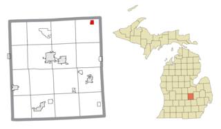
Sebewaing Township is a civil township of Huron County in the U.S. state of Michigan. The population was 2,678 at the 2020 census, which ranks it as the most populous township in the county. The village of Sebewaing is located within the township. The township was organized in 1853.

Webberville is a village in Ingham County in the U.S. state of Michigan. It is located within Leroy Township. The population was 1,288 at the 2020 census.

Alpha is a village in Mastodon Township, Iron County of the U.S. state of Michigan. The population was 126 at the 2020 census. Alpha is the only village of Iron County.

Springport is a village in Jackson County of the U.S. state of Michigan. The population was 800 at the 2010 census. The village is located within Springport Township on M-99 about 20 miles (32.2 km) northwest of Jackson. Springport High School is located in the village.

Clifford is a village in Lapeer County of the U.S. state of Michigan. The population was 324 at the 2010 census. The village is within Burlington Township.

Applegate is a village in Sanilac County of the U.S. state of Michigan. The population was 241 at the 2020 census. Applegate is in the southeast corner of Washington Township on the boundary with Sanilac Township.
New Lothrop is a village in Shiawassee County in the U.S. state of Michigan. The population was 565 at the 2020 census. The village is located within Hazelton Township.

Unionville is a village in Tuscola County in the U.S. state of Michigan. The population was 508 at the 2010 census. The village is located in the northwestern corner of Columbia Township.

Unionville is a city in Putnam County, Missouri, United States. The population was 1,735 at the 2020 census. It is the county seat of Putnam County.

Unionville is a village in Orange County, New York, United States. The population was 592 at the 2020 census, making it by far the smallest village in Orange County and one of the smallest in New York State.

Sugar Grove is a village in Fairfield County, Ohio, United States. The population was 429 at the 2020 census.

Unionville Center is a village in Union County, Ohio, in the United States. The population was 241 at the 2020 census.
Galeton is a borough in Potter County, Pennsylvania. It is located 50 miles (80 km) southeast of Bradford, Pennsylvania. Light industries, including knitting mills and a tannery have existed in Galeton. The population declined to 993 people in 2020.
Brookfield Township is a civil township of Eaton County in the U.S. state of Michigan. As of the 2020 census, the township population was 1,467.

Dover Township is a civil township of Lenawee County in the U.S. state of Michigan. As of the 2020 census, the township population was 1,662.
This page is based on this
Wikipedia article Text is available under the
CC BY-SA 4.0 license; additional terms may apply.
Images, videos and audio are available under their respective licenses.


