Sheridan Township, Huron County, Michigan

Last updated

Sheridan Township, Michigan
Sheridan Township (Huron), MI location.png
Location within Huron County
USA Michigan location map.svg
Red pog.svg
Sheridan Township
Location within the state of Michigan
Usa edcp location map.svg
Red pog.svg
Sheridan Township
Sheridan Township (the United States)
Coordinates: 43°42′54″N83°04′10″W / 43.71500°N 83.06944°W / 43.71500; -83.06944
Country United States
State Michigan
County Huron
Area
  Total36.2 sq mi (93.7 km2)
  Land36.2 sq mi (93.7 km2)
  Water0.0 sq mi (0.0 km2)
Elevation
758 ft (231 m)
Population
 (2020)
  Total627
  Density17/sq mi (6.7/km2)
Time zone UTC-5 (Eastern (EST))
  Summer (DST) UTC-4 (EDT)
ZIP code(s)
48413, 48475
Area code 989
FIPS code 26-73040 [1]
GNIS feature ID1627066 [2]

Sheridan Township is a civil township of Huron County in the U.S. state of Michigan. The population was 627 at the 2020 census. [3]

Contents

Communities

Geography

According to the United States Census Bureau, the township has a total area of 36.2 square miles (93.7 km2), all land.

Demographics

As of the census [1] of 2000, there were 736 people, 257 households, and 200 families residing in the township. The population density was 20.3 per square mile (7.9/km2). There were 279 housing units at an average density of 7.7 per square mile (3.0/km2). The racial makeup of the township was 98.51% White, 0.41% Native American, 0.14% from other races, and 0.95% from two or more races. Hispanic or Latino of any race were 0.27% of the population.

There were 257 households, out of which 37.0% had children under the age of 18 living with them, 65.4% were married couples living together, 6.2% had a female householder with no husband present, and 21.8% were non-families. 19.1% of all households were made up of individuals, and 7.0% had someone living alone who was 65 years of age or older. The average household size was 2.82 and the average family size was 3.22.

In the township the population was spread out, with 28.7% under the age of 18, 7.1% from 18 to 24, 28.7% from 25 to 44, 23.4% from 45 to 64, and 12.2% who were 65 years of age or older. The median age was 36 years. For every 100 females, there were 98.9 males. For every 100 females age 18 and over, there were 104.3 males.

The median income for a household in the township was $39,850, and the median income for a family was $45,583. Males had a median income of $31,875 versus $22,054 for females. The per capita income for the township was $19,065. About 3.9% of families and 6.5% of the population were below the poverty line, including 7.1% of those under age 18 and none of those age 65 or over.

Related Research Articles

<span class="mw-page-title-main">Sheridan Township, Clare County, Michigan</span> Civil township in Michigan, United States

Sheridan Township is a civil township of Clare County in the U.S. state of Michigan. The population was 1,548 at the 2020 census.

<span class="mw-page-title-main">Brookfield Township, Huron County, Michigan</span> Civil township in Michigan, United States

Brookfield Township is a civil township of Huron County in the U.S. state of Michigan. As of the 2020 census, the township population was 739.

<span class="mw-page-title-main">Colfax Township, Huron County, Michigan</span> Civil township in Michigan, United States

Colfax Township is a civil township of Huron County in the U.S. state of Michigan. The population was 1,753 at the 2020 census.

<span class="mw-page-title-main">Dwight Township, Michigan</span> Civil township in Michigan, United States

Dwight Township is a civil township of Huron County in the U.S. state of Michigan. The population was 708 at the 2020 census.

<span class="mw-page-title-main">Fairhaven Township, Michigan</span> Civil township in Michigan, United States

Fairhaven Township is a civil township of Huron County in the U.S. state of Michigan. The population was 1,081 at the 2020 census.

<span class="mw-page-title-main">Lake Township, Huron County, Michigan</span> Civil township in Michigan, United States

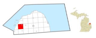
Lake Township is a civil township of Huron County in the U.S. state of Michigan. The population was 657 at the 2020 census.

<span class="mw-page-title-main">Oliver Township, Huron County, Michigan</span> Civil township in Michigan, United States

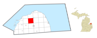
Oliver Township is a civil township of Huron County in the U.S. state of Michigan. The population was 1,419 at the 2020 census.

<span class="mw-page-title-main">Port Austin Township, Michigan</span> Civil township in Michigan, United States

Port Austin Township is a civil township of Huron County in the U.S. state of Michigan. The population was 1,384 at the 2020 census.

<span class="mw-page-title-main">Sebewaing Township, Michigan</span> Civil township in Michigan, United States

Sebewaing Township is a civil township of Huron County in the U.S. state of Michigan. The population was 2,678 at the 2020 census, which ranks it as the most populous township in the county. The village of Sebewaing is located within the township. The township was organized in 1853.

<span class="mw-page-title-main">Sherman Township, Huron County, Michigan</span> Civil township in Michigan, United States

Sherman Township is a civil township of Huron County in the U.S. state of Michigan. The population was 999 at the 2020 census.

<span class="mw-page-title-main">Sigel Township, Michigan</span> Civil township in Michigan, United States

Sigel Township is a civil township of Huron County in the U.S. state of Michigan. The population was 437 at the 2020 census.

<span class="mw-page-title-main">Verona Township, Michigan</span> Civil township in Michigan, United States

Verona Township is a civil township of Huron County in the U.S. state of Michigan. The population was 1,210 at the 2020 census.

<span class="mw-page-title-main">Winsor Township, Michigan</span> Civil township in Michigan, United States

Winsor Township is a civil township of Huron County in the U.S. state of Michigan. The population was 1,960 at the 2020 census.

Chippewa Township is a civil township of Mecosta County in the U.S. state of Michigan. As of the 2020 census, the township population was 1,227.

<span class="mw-page-title-main">Fort Gratiot Township, Michigan</span> Charter township in Michigan, United States

Fort Gratiot Township is a charter township of St. Clair County in the U.S. state of Michigan. The population was 11,242 at the 2020 Census. It is named for Fort Gratiot, an American fort located there off and on between 1814 and 1879.

Nottawa Township is a civil township of St. Joseph County in the U.S. state of Michigan. The population was 3,685 at the 2020 census. The township is named after the Nottawaseppi Huron Band of Potawatomi.

<span class="mw-page-title-main">Dexter Township, Michigan</span> Civil township in Michigan, United States

Dexter Township is a civil township of Washtenaw County in the U.S. state of Michigan. The population was 6,696 at the 2020 census. The city of Dexter is located to the southeast but does not border the township, and the two are administered autonomously.

<span class="mw-page-title-main">Ypsilanti Charter Township, Michigan</span> Charter township in Michigan, United States

Ypsilanti Charter Township is a charter township of Washtenaw County in the U.S. state of Michigan. The population was 55,670 at the 2020 census. The city of Ypsilanti is mostly surrounded by the township, but the two are administered autonomously.

<span class="mw-page-title-main">Kenockee Township, Michigan</span> Civil township in Michigan, United States

Kenockee Township is a civil township of St. Clair County in the U.S. state of Michigan. The population was 2,405 at the 2020 Census.

<span class="mw-page-title-main">Meade Township, Huron County, Michigan</span> Civil township in Michigan, United States

Meade Township is a civil township of Huron County in the U.S. state of Michigan. The population was 698 at the 2020 census.

References

Notes

  1. 1 2 "U.S. Census website". United States Census Bureau . Retrieved January 31, 2008.
  2. U.S. Geological Survey Geographic Names Information System: Sheridan Township, Huron County, Michigan
  3. "Explore Census Data". data.census.gov. Retrieved May 1, 2024.
  4. Romig 1986, p. 26.
  5. U.S. Geological Survey Geographic Names Information System: Ivanhoe, Michigan & GNIS in Google Map

Sources