Shap

Last updated

Shap
Village and parish
Shap - Market Cross.jpg
Shap Market Cross
Location map United Kingdom Eden.svg
Red pog.svg
Shap
Location in the former Eden District, Cumbria
Cumbria UK location map.svg
Red pog.svg
Shap
Location within Cumbria
Population1,264 (2011) [1]
OS grid reference NY563150
Civil parish
  • Shap
Unitary authority
Ceremonial county
  • Cumbria
Region
Country England
Sovereign state United Kingdom
Post town PENRITH
Postcode district CA10
Dialling code 01931
Police Cumbria
Fire Cumbria
Ambulance North West
UK Parliament
List of places
UK
England
Cumbria
54°31′44″N2°40′34″W / 54.529°N 2.676°W / 54.529; -2.676

Shap is a village and civil parish located among fells and isolated dales in Westmorland and Furness, Cumbria, England. The village is in the historic county of Westmorland. The parish had a population of 1,221 in 2001, [2] increasing slightly to 1,264 at the 2011 Census. [1]

Contents

Location

The village lies along the A6 road and the West Coast Main Line, and is near to the M6 motorway. It is situated 10 miles (16 km) from Penrith and about 15 miles (24 km) from Kendal.

Shap is on the route of the Coast to Coast Walk.

Etymology

Early (12th and 13th century) forms such as Hep and Yheppe point to an Old Norse rendering Hjáp of an Old English original Hēap = "heap", (of stones), probably referring to an ancient stone circle, cairn, or to the Shap Stone Avenue just to the west of the village. [3]

History

Although Shap is geographically a small village, it is legally a market town with a charter dating from the 17th century. The parish was, between 1905 and 1935, administered by an urban district council. At one time, the granite works (which are situated about a mile outside the village) was in itself a separate community, with its own Co-op store. Shap polished pink granite can be found in many buildings in the UK, including outside St Paul's Cathedral in London.

Shap today

St. Michael's Church St Michaels Church, Shap with Swindale - geograph.org.uk - 551119.jpg
St. Michael's Church

The village has three pubs, a small supermarket, a fish and chip shop, an antique book shop, a butcher's shop, a primary school, a newsagent's, a coffee shop, a ceramic art studio called Edge Ceramics, a fire station, an Anglican church and 3 B&B/ Hostels. There is also a small library, which is in the process of being relinquished from local council control and being adopted by the community as part of a budget cutting measure.

Major employers in the area are Hanson and Tata Steel.

Some of the scenes in the feature film Withnail and I were filmed around Shap. Sleddale Hall, the filming location for Uncle Monty's cottage Crow Crag, is located near Wet Sleddale Reservoir.

On 22 October 1999, a Hawk jet from RAF Leeming crashed into an empty barn in the village before disintegrating across the A6 and West Coast railway line, killing its two-man crew.

Attractions

Shap Summit Shap Summit - geograph.org.uk - 535853.jpg
Shap Summit

Shap Summit is located on the motorway at NY583120 and the railway at NY570110 . Shap Fell used to be notorious for the difficult and dangerous stretch of A6 for drivers, and it includes a well-known section of the West Coast Main Line. It has a 1:75 gradient for trains heading north, and in the days of steam locomotives banking engines from Tebay were often used to assist trains. It has been popular with railway photographers and there have been many pictures published taken in the area, most notably at Scout Green which lies on the southern approach to the hill.

Shap Fell NY530088 is known for Shap granite, [4] a pink rock rich in orthoclase, quartz and biotite; Shap Pink Quarry NY557083 takes its name from this.

Shap Abbey NY547151 is nearby in the secluded valley of the river Lowther. Now impressive ruins dating from 1199, the Abbey was one of the last abbeys to be dissolved by Henry VIII in 1540.

Shap Wells has a mineral spa located in the grounds of the Shap Wells hotel which was used in World War II as a prisoner of war camp.

In literature

A scene in Robert Neill's historical novel Crown and Mitre is laid in Shap. In 1659 the book's protagonist Hal Burnaby, a young Royalist, rides through the village on a clandestine mission connected with the restoration of King Charles II. Shap also appears in Anthony Trollope's novel Can You Forgive Her? as the nearest village to Vavasor Hall, the ancestral home of the heroine Alice Vavasor.

Governance

The civil parish of Shap (formerly Shap Urban Parish) includes the hamlet of Keld and parts of the granite works and limestone works, and has a population of 1,221, [5] increasing to 1,264 at the 2011 Census. The parish shares a joint parish council and an electoral ward with Shap Rural. The total population of the electoral ward taken at the 2011 census was 1,394. [6] [7] [8]

Shap is in the parliamentary constituency of Penrith and the Border. Neil Hudson was elected its Conservative Member of Parliament at the 2019 General Election, replacing Rory Stewart.

Prior to Brexit, for the European Parliament its residents voted to elect MEP's for the North West England constituency.

For local government purposes the village is in Westmorland and Furness. Until 2023 it was in the Shap Ward of Eden District Council and the Eden Lakes Division of Cumbria County Council.

Transport

The Lancaster and Carlisle Railway (now part of the West Coast Main Line), opened on 17 December 1846, and runs along the eastern edge of the village. Shap railway station was closed in 1968, though there have been calls for its re-opening. [9] Penrith is the closest railway station and is situated on the West Coast Main Line.

Dialect

Though the majority of the village's inhabitants speak standard English, some of the people of Shap and the surrounding area speak a variant of the Penrithian dialect, which is itself a variant of the Cumbrian dialect spoken around the Penrith and Eden district area. These dialectal varieties stem from Northern Middle English and in turn Northumbrian Old English.

Notable people

See also

Related Research Articles

<span class="mw-page-title-main">Westmorland</span> Historic county of England

Westmorland is a historic county in Northern England.

<span class="mw-page-title-main">Appleby-in-Westmorland</span> Market town in Cumbria, England

Appleby-in-Westmorland is a market town and civil parish in Westmorland and Furness, Cumbria, England, with a population of 3,048 at the 2011 Census. Crossed by the River Eden, Appleby is the county town of the historic county of Westmorland. It was known just as Appleby until 1974–1976, when the council of the successor parish to the borough changed it to retain the name Westmorland, which was abolished as an administrative area under the Local Government Act 1972, before being revived as Westmorland and Furness in 2023. It lies 14 miles (23 km) south-east of Penrith, 32 miles (51 km) south-east of Carlisle, 27 miles (43 km) north-east of Kendal and 45 miles (72 km) west of Darlington.

<span class="mw-page-title-main">Eden District</span> Former local government district in England

Eden was a local government district in Cumbria, England, based at Penrith Town Hall in Penrith. It was named after the River Eden, which flows north through the district toward Carlisle. Its population of 49,777 at the 2001 census, increased to 52,564 at the 2011 Census. A 2019 estimate was 53,253. In July 2021 it was announced that, in April 2023, Cumbria would be divided into two unitary authorities. On 1 April 2023, Eden District Council was abolished and its functions transferred to the new authority Westmorland and Furness, which also covers the former districts of Barrow-in-Furness and South Lakeland.

<span class="mw-page-title-main">Penrith, Cumbria</span> Market town in Cumbria, England

Penrith is a market town and civil parish in the Westmorland and Furness district of Cumbria, England. It is less than 3 miles (5 km) outside the Lake District National Park and about 17 miles (27 km) south of Carlisle. It is between the Rivers Petteril and Eamont and just north of the River Lowther. The town had a population of 15,181 at the 2011 census. It is part of historic Cumberland.

<span class="mw-page-title-main">Eden Valley Railway</span> Former railway

The Eden Valley Railway (EVR) was a railway in Cumbria, England. It ran between Clifton Junction near Penrith and Kirkby Stephen via Appleby-in-Westmorland.

<span class="mw-page-title-main">Kirkby Stephen</span> Market town in Cumbria, England

Kirkby Stephen is a market town and civil parish in Westmorland and Furness, Cumbria, England. Historically part of Westmorland, it lies on the A685, surrounded by sparsely populated hill country, about 25 miles (40 km) from the nearest larger towns: Kendal and Penrith. The River Eden rises 6 miles (9.7 km) away in the peat bogs below Hugh Seat and passes the eastern edge of the town. At the 2001 census the parish had a population of 1,832. In 2011, it had a population of 1,522.

<span class="mw-page-title-main">Longsleddale</span> Valley and civil parish in Cumbria, England

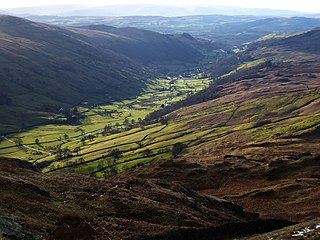
Longsleddale is a valley and civil parish in the South Lakeland district of Cumbria, England. It includes the hamlet of Sadgill. The parish has a population of 73. As the population taken at the 2011 Census was less than 100, details are maintained in the civil parish of Whitwell and Selside.

<span class="mw-page-title-main">Orton, Westmorland and Furness</span> Village in Cumbria, England

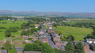
Orton is a village and civil parish in Cumbria, England. It lies 15 miles (24 km) south of Penrith, 8 miles (13 km) from Appleby-in-Westmorland and 1.5 miles (2.4 km) from the M6 motorway. The village is in the upper Lune Valley, at the foot of Orton Scar in the Orton Fells. The Lake District is nearby. The parish includes a wide area outside the village, and had a population of 594 in 2001, decreasing to 588 at the 2011 Census.

<span class="mw-page-title-main">Tebay Services</span> Motorway service stations in Cumbria, England

Tebay Services are motorway service stations on the M6 motorway in the Westmorland and Furness district of Cumbria, England. The northbound opened in 1972 and the southbound in 1993. They are known for their family-run business which eschews the typical facilities at British motorway services for a farm shop and buildings in keeping with the local environment.

<span class="mw-page-title-main">Shap Summit</span> Hill in Cumbria, United Kingdom

Shap Summit refers to three different route summits in close proximity, of the A6 road, M6 motorway and the highest point of the West Coast Main Line railway in England, near to the Cumbria village of Shap in North West England, crossing the hills of the Lake District.

<span class="mw-page-title-main">Tebay</span> Human settlement in England

Tebay is a village and civil parish in Cumbria, England, within the historic borders of Westmorland. It lies in the upper Lune Valley, at the head of the Lune Gorge. The parish had a population of 728 in the 2001 census, increasing to 776 at the Census 2011.

<span class="mw-page-title-main">Hesket, Cumbria</span> Parish in Cumbria, England

Hesket is a large civil parish in the Eden District of Cumbria, England, on the main A6 between Carlisle and Penrith. At the 2001 census it had a population of 2,363, increasing to 2,588 at the 2011 census, and estimated at 2,774 in 2019. The parish was formed in 1894 with the passing of the Local Government Act 1894 and was enlarged to incorporate the parish of Plumpton Wall following a County Review Order in 1934. Hesket is part of the historic royal hunting ground of Inglewood Forest. Settlement in the parish dates back to the Roman occupation.

<span class="mw-page-title-main">Shap Rural</span> Civil parish in England

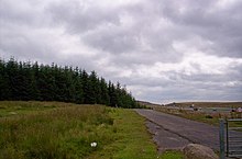
Shap Rural is a very large, but sparsely populated, civil parish in the Eden district of Cumbria in England, covering part of the Lake District National Park. It had a population of 119 in 2001, 130 at the 2011 Census, and 110 in 2021.

<span class="mw-page-title-main">Kirkby Thore</span> Human settlement in England

Kirkby Thore is a small village and civil parish in Cumbria, England, in the historic county of Westmorland. It is close to the Lake District national park and the Cumbrian Pennines. It includes the areas of Bridge End, in the southwest by the A66, and Cross End in the northeast of the village. In the 2001 census, the parish had a population of 731, increasing to 758 in the 2011 Census. The market town of Appleby-in-Westmorland is about five miles away, and the larger town of Penrith is about eight miles away.

<span class="mw-page-title-main">River Lowther</span> River in Cumbria, England

The River Lowther is a small river which flows through limestone rock in Cumbria, England. It is a tributary of the River Eamont which in turn is a tributary of the River Eden which flows into the Solway Firth near Carlisle. The Lowther begins with the confluence of the Keld Gill and the Keld Dub near the village of Keld. It flows north-west until it passes between Bampton and Bampton Grange, before turning north until it flows into the River Eamont close to Penrith.

<span class="mw-page-title-main">Borrow Beck</span> Stream in Cumbria, England

Borrow Beck is a stream running through Cumbria, England on the eastern edge of the English Lake District. The area previously formed part of the traditional county of Westmorland.

<span class="mw-page-title-main">Newbiggin-on-Lune</span> Human settlement in England

Newbiggin-on-Lune is a village in the Eden district of Cumbria, England. Historically in Westmorland it is about 4 miles (6.4 km) south west of Kirkby Stephen, and lies on the main A685 route from Brough to Tebay. Nearby to the north is located the Smardale Gill Viaduct on the dismantled former South Durham & Lancashire Union Railway between Tebay and Kirkby Stephen East railway station. To the south lies the Howgill Fells including Green Bell 1,985 feet.

<span class="mw-page-title-main">Yanwath</span> Village in Cumbria, England

Yanwath is a village in the Westmorland and Furness District of Cumbria, England, 1 mile south of Penrith.

<span class="mw-page-title-main">Little Strickland</span> Human settlement in England

Little Strickland is a small village and civil parish in the Eden district of Cumbria, England. It is about 7 miles (11 km) from Penrith and 8 miles (13 km) from the small town of Appleby-in-Westmorland. The village has one place of worship and a telephone box. The population of the civil parish as taken at the 2011 Census was less than 100. Details are included in the parish of Great Strickland. On 1 April 2019 Thrimby parish was merged with Little Strickland.

<span class="mw-page-title-main">Thrimby</span> Human settlement in England

Thrimby is a hamlet and former civil parish, now in the parish of Little Strickland, in the Eden district of Cumbria, England. In 2001 the population of the civil parish of Thrimby was 30. The population measured at the 2011 Census was less than 100. Details are included in the parish of Great Strickland. It has a Grade 2* farmhouse called Thrimby Hall, as seen in series 4 of the BBC Two fly-on-the-wall farming documentary "This Farming Life".

References

  1. 1 2 UK Census (2011). "Local Area Report – Shap Parish (E04002568)". Nomis. Office for National Statistics . Retrieved 20 April 2021.
  2. UK Census (2001). "Local Area Report – Shap Parish (16UF059)". Nomis. Office for National Statistics . Retrieved 20 April 2021.
  3. Whaley, Diana (2006). A dictionary of Lake District place-names. Nottingham: English Place-Name Society. pp. lx, 423 p.305. ISBN   0904889726.
  4. "Shap granite".
  5. Office for National Statistics : Census 2001 : Parish Headcounts : Eden Archived 9 October 2014 at the Wayback Machine Retrieved 21 November 2009
  6. "Ward population 2011" . Retrieved 22 June 2015.
  7. "Shap Parish Council". 7 October 2013.
  8. "councilportal.cumbria.gov.uk - Shap Parish Council". 30 November 2022.
  9. "Plea to reopen Shap and Tebay rail stations". Cumberland & Westmorland Herald. 21 September 2012. Retrieved 22 June 2018.