Southern Thule

Last updated

Southern Thule
Southern Thule Islands ASTER.jpg
The western islands of Southern Thule
Thule-Location.JPG
Geography
LocationSouthern Atlantic Ocean
Coordinates 59°25′S27°14′W / 59.42°S 27.23°W / -59.42; -27.23 [1]
Archipelago South Sandwich Islands
Administration
United Kingdom
South Georgia and the South Sandwich Islands

Southern Thule is a group of the three southernmost islands in the South Sandwich Islands in the southern Atlantic Ocean: Bellingshausen, Cook, and Thule (Morrell). It is a largely submerged volcano of which only the three islands emerge above sea level. Between Cook and Thule, and south of Bellingshausen, lie two submerged calderas; a third caldera is located on Thule. Cook Island is inactive and largely glaciated, while Bellingshausen and Thule feature active craters with fumarolic activity, and there is evidence of eruptions in the 20th century.

Contents

Around the fumaroles, a vegetation consisting of mosses and lichens has grown. The islands are populated by penguins and seabirds which breed there. The islands were discovered in 1775 and are uninhabited. They are part of a marine protected area that is part of the British Overseas Territory of South Georgia and the South Sandwich Islands.

Geography and geology

Regional

Southern Thule is the southernmost island group in the South Sandwich Islands, [2] an archipelago in the Southern Atlantic Ocean. [3] The South Sandwich Islands are a group of eleven volcanic islands, most of which are volcanically active. [4] They are located about 2,000 kilometres (1,200 mi) north of Antarctica and about the same distance southeast from the Falklands Islands. [1] Politically, the South Sandwich Islands are an UK Overseas Territory and managed as part of the South Georgia and South Sandwich Islands. They were declared a marine protected area in 2012, with additional expansion taking place in 2019. [5]

Local

The Southern Thule group consists of three islands, the southern-most pair Thule Island and Cook Island, and the smaller Bellingshausen Island to their northeast. [6] They rise from an east-west trending [7] wave-cut platform on top of a broad submerged volcano with a width of 30 kilometres (19 mi), [8] and a length of 63 kilometres (39 mi) at 2,000 metres (6,600 ft) depth. The western side of the volcano has steeper slopes than the eastern side. [9] The flanks of this volcano feature ridges and domes, as well as traces of mass wasting such as chutes. [10] The islands are surrounded by shallow shelves at 120–130 metres (390–430 ft) depth, which probably formed through erosion during glacial periods, when sea levels were lower. [11] Several seamounts lie south and west of Southern Thule, including Kemp Caldera, Adventure Bank and Nelson Seamount. [12]

Bellingshausen and Thule Islands are both simple volcanic cones with a summit crater. The crater on Thule is water-filled, and there is a parasitic vent on the southeastern side of the island. Cook Island is more complex and might consist of multiple volcanic cones. [13] Where there are outcrops, all three islands appear to consist of layers of lava flows and scoria or pyroclastics. [14]

Between Cook and Thule Island lies the Douglas Strait with a 4.8 by 4.3 kilometres (3.0 mi × 2.7 mi) caldera [31] at 620 metres (2,030 ft) depth. [32] Elsewhere, the sea between the two islands only reaches depths of 55 metres (180 ft) [33] and the strait is no more than 6-kilometre (3.7 mi) wide, [34] its seafloor covered with sediment. [35] The caldera floor contains a debris mound that may have formed from a landslide at Thule Island. [31] Other features are concentric arches that may indicate that the caldera is nested, and large cones that could be tephra cones. [36] Another submarine caldera is located south of Bellingshausen Island and east of Cook Island; [34] it is named Resolution Caldera and is open to the south. [7] It reaches a depth of 276 metres (906 ft) below sea level, while its eastern rim rises to a depth of 35 metres (115 ft), and has a width of 3–4 kilometres (1.9–2.5 mi). [9] The Douglas Strait caldera has an estimated volume of 9–12 cubic kilometres (2.2–2.9 cu mi) and the Resolution one of 3 cubic kilometres (0.72 cu mi); both may have formed through multiple eruptions. [37]

Composition

Bellingshausen has produced basaltic andesite, while Cook volcanic rocks range from basalt to dacite [13] and Thule has produced andesite and dacite. Phenocrysts include augite, hypersthene and plagioclase. [38] All volcanic rocks define a predominantly tholeiitic suite, [39] but there are calc-alkaline members. [40] The tholeiitic magmas form through the melting of pyrolite mantle triggered by the entry of water released from the subducted crust in about 80–100 kilometres (50–62 mi) depth. The calc-alkaline magmas form when the subducted crust undergoes a transformation into eclogite-quartz at depths of 100–300 kilometres (62–186 mi), which upon melting yields the calc-alkaline melts. [41] Palagonite tuffs crop out on Bellingshausen [42] and Thule. [38]

Climate, vegetation and animal life

Mean temperatures in the South Sandwich Islands hover around freezing; [43] at Southern Thule they are estimated to range between −1 and −11 °C (30 and 12 °F). [44] Sea ice covers the sea for about three months a year, [30] and wave heights reach 15 metres (49 ft). [12] Winds blow mostly from south and northwest, and frequent extratropical cyclones and storms pass through the archipelago. The sky is usually overcast, with frequent precipitation falling mostly as snow. [45]

Bellingshausen Island is richly vegetated, with mosses and hepatics growing all around the fumaroles and even away from them. They are in turn colonized by collemboles and mites. [21] The plant communities around the fumarolic vents form characteristic concentric populations, [19] while mosses form carpets in gullies. [46] Cook Island by contrast appears to be lacking vegetation entirely, even if lichens may be present, [47] and Thule Island likewise seems to largely lack vegetation [48] except for lichens. [49] The flora resembles that of Antarctic and South Atlantic cold temperate climate zones. [50]

Chinstrap penguins and macaroni penguins nest on Bellingshausen and Thule Island, as well as gulls, skuas, snow petrels and Wilson's petrels. [51] Fur seals and southern elephant seals breed on the islands. [52] Antarctic petrels, [53] Antarctic terns, [54] emperor penguins and king penguins also visit the islands. [55]

The principal animals on the submarine slopes of Southern Thule are annelids, crustaceans, molluscs and nematodes. [56] The shallow waters around Southern Thule provide habitats for sea spiders. [57] The submarine habitat may have been severely impacted by the formation of the Douglas Strait caldera and the eruption that caused it. [58] Presently, frequent mass wasting regularly buries the submarine slopes, devastating faunal communities. [59]

Eruption history

The simple structure of Bellingshausen Island implies it is probably among the most recently formed of the South Sandwich Islands. [60] Thule and Cook Islands probably were once part of a common volcano centered on Douglas Strait, but large parts of both islands formed independently from this common volcano. [48] Some landforms in the caldera are very fresh and may have formed recently. [24] The Douglas Strait caldera may have formed only a few thousands of years ago. [58]

Fumaroles have been observed in the summit craters of Bellingshausen and Thule, while Cook displays no evidence of fumarolic activity. [13] The Bellingshausen fumaroles occur around the southern side of the crater and their vents have various shapes and sizes. Some are surrounded by sulfur deposits. Parts of the island are heated from below. [60] The composition of fumarolic gases at Bellingshausen shows a predominance of water vapor, with lesser quantities of carbon dioxide and traces of hydrogen and hydrogen sulfide. [61]

In 1963, volcanic ash was observed overlying ice on the southwestern side of Thule, perhaps indicating a recent eruption. [13] A similar observation was made with scoria on Thule Island the preceding year, when a secondary crater may have been active. [48] Several craters formed on the southern flank of Bellingshausen Island between 1964 and 1997. [32] Seismic activity has been recorded around Southern Thule. [62] There are no known eruptions at Cook Island [47] nor any recorded hydrothermal activity in Douglas Strait [31] or Resolution caldera. [63]

Human history

Penguins and human structures at Hewison Point Baliza Punta Hewison, Isla Thule.jpg
Penguins and human structures at Hewison Point

The South Sandwich Islands were discovered by James Cook in 1775. [2] He also saw the peaks of the Southern Thule group, and named them "Thule" as they were the southernmost land known at that time. [64] The Bellingshausen expedition of 1819 established that "Southern Thule" was a group of three islands, naming one of them Cook Island after their discoverer. Later, the islands were visited by sealers, which may have overexploited the seals of the archipelago, leading to their almost-disappearance. [65] The hostile conditions and remote location mean that they are seldom visited. [34]

In 1954–1956, the Argentines built a hut on Thule Island, at Hewison Point, and named it "Teniente Esquivel", but abandoned it after witnessing a large eruption on Bristol Island. [66] At the same place, the Argentines built a research station "Corbeta Uruguay". [67] The Argentine actions in Southern Thule were part of a wider conflict between Chile, Argentina and the United Kingdom; they prompted complaints by the United Kingdom, but nothing was actually done until the Falklands War. [68] The research station was demolished by the Royal Navy in 1982 at the end of the war. [69]

Related Research Articles

<span class="mw-page-title-main">South Georgia and the South Sandwich Islands</span> British Overseas Territory in the South Atlantic

South Georgia and the South Sandwich Islands (SGSSI) is a British Overseas Territory in the southern Atlantic Ocean. It is a remote and inhospitable collection of islands, consisting of South Georgia and a chain of smaller islands known as the South Sandwich Islands. South Georgia is 165 kilometres (103 mi) long and 35 kilometres (22 mi) wide and is by far the largest island in the territory. The South Sandwich Islands lie about 700 kilometres (430 mi) southeast of South Georgia. The territory's total land area is 3,903 km2 (1,507 sq mi). The Falkland Islands are about 1,300 kilometres (810 mi) west from its nearest point.

<span class="mw-page-title-main">South Sandwich Islands</span> Island chain in South Atlantic Ocean

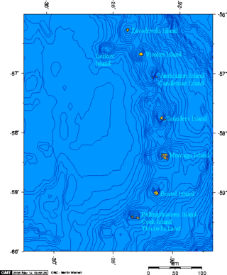
The South Sandwich Islands are a chain of uninhabited volcanic islands in the South Atlantic Ocean. They are administered as part of the British Overseas Territory of South Georgia and the South Sandwich Islands. The chain lies in the sub-Antarctic region, about 700 kilometres (430 mi) southeast of South Georgia and 1,700 kilometres (1,100 mi) northeast from the tip of the Antarctic Peninsula.

<span class="mw-page-title-main">Deception Island</span> Active volcanic island in the South Shetland archipelago

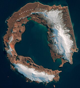
Deception Island is in the South Shetland Islands close to the Antarctic Peninsula with a large and usually "safe" natural harbor, which is occasionally affected by the underlying active volcano. This island is the caldera of an active volcano, which seriously damaged local scientific stations in 1967 and 1969. The island previously held a whaling station. It is now a tourist destination with over 15,000 visitors per year. Two research stations are operated by Argentina and Spain during the summer season. While various countries have asserted sovereignty, it is still administered under the Antarctic Treaty System.

<span class="mw-page-title-main">Bellingshausen Island</span> Island in the Southern Thule group of the South Sandwich Islands

Bellingshausen Island is one of the most southerly of the South Sandwich Islands, close to Thule Island and Cook Island, and forming part of the Southern Thule group. It is named after its discoverer, Russian Antarctic explorer Fabian von Bellingshausen (1778–1852).

<span class="mw-page-title-main">Thule Island</span> Island in the Southern Thule group of the South Sandwich Islands

Thule Island, also called Morrell Island, is one of the southernmost of the South Sandwich Islands, part of the grouping known as Southern Thule. It is named, on account of its remote location, after the mythical land of Thule, said by ancient geographers to lie at the extreme end of the Earth. The alternative name Morrell Island is after Benjamin Morrell, an American explorer and whaling captain. It was espied by James Cook and his Resolution crew on 31 January 1775 during his attempt to find Terra Australis.

<span class="mw-page-title-main">Vindication Island</span> Island in the South Sandwich Islands

Vindication Island is a small uninhabited island of the Candlemas Islands in the South Sandwich Islands. It is one of about a dozen islands that make up the South Sandwich island arc, a chain of volcanoes in the Southern Ocean that was discovered in 1775 by James Cook. The volcanism is caused by the subduction of the South American Plate beneath the Sandwich Plate.

<span class="mw-page-title-main">Cook Island, South Sandwich Islands</span> Island in the Southern Thule group of the South Sandwich Islands

Cook Island is the central and largest island of the Southern Thule island group, part of the South Sandwich Islands in the far south Atlantic Ocean. Southern Thule was discovered by a British expedition under Captain James Cook in 1775. Cook Island was named for Cook by a Russian expedition under Fabian Gottlieb von Bellingshausen, which explored the South Sandwich islands in 1819–1820.

<span class="mw-page-title-main">Bridgeman Island (South Shetland Islands)</span> Island in Antarctica

Bridgeman Island is one of the South Shetland Islands in Antarctica. It is an almost circular, volcanic island marked by steep sides, measuring 900 by 600 metres with a maximum elevation of 240 m (787 ft) high, lying 45 kilometres (28 mi) east of King George Island.

<span class="mw-page-title-main">Traversay Islands</span> Three northernmost South Sandwich Islands

The Traversay Islands are a group of three islands—Zavodovski, Leskov and Visokoi—at the northern end of the South Sandwich Islands.

<span class="mw-page-title-main">Protector Shoal</span> Submarine volcano NW of Zavodovski Island in the South Sandwich Islands

Protector Shoal is the shallowest point of the Protector Seamounts, a group of submarine volcanoes in the Southern Ocean. They are part of the South Sandwich island arc, a volcanic arc that has given rise to the South Sandwich Islands. Protector Shoal reaches a depth of 55 metres (180 ft) below sea level and is part of a larger group of seamounts that formed atop a larger ridge. Some of these seamounts bear traces of sector collapses, and one is capped by nested calderas.

Peter Edward Baker (1937–2008) was a notable British volcanologist, professor emeritus of Igneous Petrology in the School of Earth Sciences, University of Leeds.

<span class="mw-page-title-main">Mount Berlin</span> Volcano in West Antarctica

Mount Berlin is a glacier-covered volcano in Marie Byrd Land, Antarctica, 100 kilometres (62 mi) from the Amundsen Sea. It is a roughly 20-kilometre-wide (12 mi) mountain with parasitic vents that consists of two coalesced volcanoes: Berlin proper with the 2-kilometre-wide (1.2 mi) Berlin Crater and Merrem Peak with a 2.5-by-1-kilometre-wide crater, 3.5 kilometres (2.2 mi) away from Berlin. The summit of the volcano is 3,478 metres (11,411 ft) above sea level. It has a volume of 200 cubic kilometres (48 cu mi) and rises from the West Antarctic Ice Sheet. It is part of the Marie Byrd Land Volcanic Province. Trachyte is the dominant volcanic rock and occurs in the form of lava flows and pyroclastic rocks.

Kemp Caldera and Kemp Seamount form a submarine volcano south of the South Sandwich Islands, in a region where several seamounts are located. The seamount rises to a depth of 80 metres (260 ft) below sea level; the caldera has a diameter of 8.3 by 6.5 kilometres and reaches a depth of 1,600 metres (5,200 ft). The caldera contains several Hydrothermal vents, including white smokers and diffuse venting areas, which are host to chemolithotrophic ecological communities. The seamount and caldera, which were discovered by seafloor mapping in 2009, are part of the South Georgia and the South Sandwich Islands Marine Protected Area.

<span class="mw-page-title-main">Leskov Island</span> Island in the South Sandwich Islands

Leskov Island is an island in the South Sandwich Islands named after Russian sailor Arcady Leskov. It is a semicircular 190 metres (620 ft) high eroded volcano with a large bay on its eastern side. Leskov Island is almost entirely surrounded by cliffs and has a surface area of 0.55 by 0.93 kilometres. Volcanic rocks form tuffs and lava and consist almost entirely of andesite.

<span class="mw-page-title-main">Saunders Island, South Sandwich Islands</span> British island in the southern Atlantic

Saunders Island is a crescent-shaped island 8.5 by 5 kilometres long, lying between Candlemas Island and Montagu Island in the South Sandwich Islands, a British Overseas Territory in the southern Atlantic Ocean. It is a volcanic island composed of an active stratovolcano, 990-metre (3,248 ft) Mount Michael, and a cluster of pyroclastic cones on the southeastern side. Mount Michael has a lava lake in its summit crater, which is fumarolically active, and there is widespread evidence of recent eruptions across the island.

<span class="mw-page-title-main">Candlemas Island</span> Island of the Candlemas Islands in the South Sandwich Islands

Candlemas Island is a small uninhabited island of the Candlemas Islands in the South Sandwich Islands. It is one of about a dozen islands that make up the South Sandwich island arc, a chain of volcanoes in the Southern Ocean that was discovered in 1775 by James Cook. The volcanism is caused by the subduction of the South American Plate beneath the Sandwich Plate. The island is remote and rarely visited due to the often hostile weather conditions, but is populated by penguins and seabirds, which form large breeding colonies.

<span class="mw-page-title-main">Zavodovski Island</span> Volcanic island in the South Atlantic

Zavodovski Island is an uninhabited volcanic island in the Traversay Islands subgroup of the South Sandwich Islands, which are located southeast of South Georgia in the South Atlantic Ocean. It is the northernmost of the South Sandwich Islands and consists of one major stratovolcano, Mount Curry, which is surrounded to the east by a plain formed by lava flows. Mount Curry has a fumarolically active crater on the southwestern side, which also bears traces of a sector collapse. An eruption occurred in 2016.

<span class="mw-page-title-main">Visokoi Island</span> Uninhabited island in the South Sandwich Islands

Visokoi Island is an uninhabited volcanic island in the Traversay Islands subgroup of the South Sandwich Islands, which are located southeast of South Georgia. It consists of one major volcano, Mount Hodson whose height is usually given as 1,005 metres (3,297 ft). The mountain is mostly covered by glaciers, except for several low areas on the coast like the northern Finger Point and eastern Irving Point. Several parasitic vents are found especially on the eastern side, and one vent close to Finger Point is still hot. Eruptions were reported in 1830, 1927 and 1930.

<span class="mw-page-title-main">Montagu Island</span> Largest of the South Sandwich Islands

Montagu Island is the largest of the South Sandwich Islands, located in the Scotia Sea off the coast of Antarctica. It is almost entirely ice-covered with only sparse rocky outcrops, and consists of a large caldera with a large parasitic cone, Mount Oceanite. Several secondary volcanic cones have formed in the caldera, including Mount Belinda.

<span class="mw-page-title-main">Bristol Island</span> Island in the South Sandwich Islands

Bristol Island is an uninhabited island in the South Sandwich Islands. The island is almost entirely surrounded by ice cliffs and largely covered with ice. It features both the oldest rocks of this archipelago and an active volcano that last erupted in 2016.

References

  1. 1 2 Allen & Smellie 2008, p. 301.
  2. 1 2 Baker 1978, p. 3.
  3. Lynch et al. 2016, p. 1615.
  4. Baker 1978, p. 4.
  5. Liu et al. 2020, p. 3.
  6. Holdgate & Baker 1979, p. 3.
  7. 1 2 Leat et al. 2013, p. 68.
  8. 1 2 3 Allen & Smellie 2008, p. 302.
  9. 1 2 Leat et al. 2013, p. 69.
  10. Leat et al. 2013, p. 70.
  11. Leat et al. 2013, p. 73.
  12. 1 2 Rogers, Yesson & Gravestock 2015, p. 24.
  13. 1 2 3 4 Baker 1978, p. 8.
  14. 1 2 Liu et al. 2020, p. 14.
  15. Holdgate & Baker 1979, p. 54.
  16. Holdgate & Baker 1979, p. 55.
  17. 1 2 3 Holdgate & Baker 1979, p. 56.
  18. Holdgate & Baker 1979, p. 57.
  19. 1 2 Longton & Holdgate 1979, p. 29.
  20. Patrick & Smellie 2013, p. 490.
  21. 1 2 3 Holdgate & Baker 1979, p. 60.
  22. 1 2 Holdgate & Baker 1979, p. 61.
  23. Holdgate & Baker 1979, p. 62.
  24. 1 2 Allen & Smellie 2008, p. 307.
  25. 1 2 Holdgate & Baker 1979, p. 64.
  26. 1 2 Holdgate & Baker 1979, p. 66.
  27. Rogers, Yesson & Gravestock 2015, p. 40.
  28. Patrick & Smellie 2013, p. 491.
  29. 1 2 Patrick & Smellie 2013, p. 492.
  30. 1 2 Allen & Smellie 2008, p. 303.
  31. 1 2 3 Smellie et al. 1998, p. 172.
  32. 1 2 Allen & Smellie 2008, p. 305.
  33. Holdgate & Baker 1979, p. 68.
  34. 1 2 3 Smellie et al. 1998, p. 171.
  35. Rogers, Yesson & Gravestock 2015, p. 23.
  36. Allen & Smellie 2008, p. 306.
  37. Leat et al. 2013, p. 74.
  38. 1 2 Baker 1978, p. 13.
  39. Baker 1978, p. 21.
  40. Baker 1978, p. 23.
  41. Baker 1978, p. 24.
  42. Baker 1978, p. 12.
  43. Holdgate & Baker 1979, p. 13.
  44. Longton & Holdgate 1979, p. 6.
  45. Holdgate & Baker 1979, p. 14.
  46. Longton & Holdgate 1979, p. 30.
  47. 1 2 Holdgate & Baker 1979, p. 63.
  48. 1 2 3 Holdgate & Baker 1979, p. 67.
  49. Longton & Holdgate 1979, p. 8.
  50. Longton & Holdgate 1979, p. 12.
  51. Holdgate & Baker 1979, pp. 60, 67.
  52. Convey, Morton & Poncet 1999, p. 120.
  53. Convey, Morton & Poncet 1999, p. 115.
  54. Convey, Morton & Poncet 1999, p. 119.
  55. Convey, Morton & Poncet 1999, p. 113.
  56. Kaiser et al. 2008, p. 284.
  57. Leese, Dömel & Convey 2015, p. 488.
  58. 1 2 Kaiser et al. 2008, p. 282.
  59. Kaiser et al. 2008, p. 285.
  60. 1 2 Holdgate & Baker 1979, p. 59.
  61. Liu et al. 2020, p. 17.
  62. Shuler, Nettles & Ekström 2013, p. 157.
  63. Leat et al. 2013, p. 75.
  64. Holdgate & Baker 1979, p. 4.
  65. Holdgate & Baker 1979, p. 5.
  66. Holdgate & Baker 1979, p. 6.
  67. Convey, Morton & Poncet 1999, p. 108.
  68. Donaghy 2014, p. 134.
  69. Hart & Convey 2018, p. 21.

Sources

Commons-logo.svg Media related to Southern Thule Islands at Wikimedia Commons