The North Sea lies between Great Britain, Denmark, Norway, Germany, the Netherlands, Belgium and France. An epeiric sea on the European continental shelf, it connects to the Atlantic Ocean through the English Channel in the south and the Norwegian Sea in the north. It is more than 970 kilometres (600 mi) long and 580 kilometres (360 mi) wide, covering 570,000 square kilometres (220,000 sq mi).

The IJsselmeer, also known as Lake IJssel in English, is a closed-off inland bay in the central Netherlands bordering the provinces of Flevoland, North Holland and Friesland. It covers an area of 1,100 km2 (420 sq mi) with an average depth of 4.5 m (15 ft). The river IJssel flows into the IJsselmeer.
The Delta Works is a series of construction projects in the southwest of the Netherlands to protect a large area of land around the Rhine–Meuse–Scheldt delta from the sea. Constructed between 1954 and 1997, the works consist of dams, sluices, locks, dykes, levees, and storm surge barriers located in the provinces of South Holland and Zeeland.

The Afsluitdijk is a major dam and causeway in the Netherlands. It was constructed between 1927 and 1932 and runs from Den Oever in North Holland province to the village of Zurich in Friesland province, over a length of 32 kilometres (20 mi) and a width of 90 metres (300 ft), at an initial height above Amsterdam Ordnance Datum of between 6.7 metres (22 ft) along the section at Friesland, and 7.4 metres (24 ft) where it crosses the deep channel of the Vlieter. The height at the greater sea depths west of Friesland was required to be a minimum of 7 metres everywhere when originally constructed.

A storm surge, storm flood, tidal surge, or storm tide is a coastal flood or tsunami-like phenomenon of rising water commonly associated with low-pressure weather systems, such as cyclones. It is measured as the rise in water level above the normal tidal level, and does not include waves.

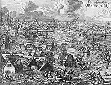
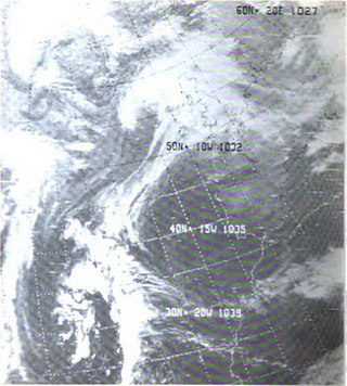
The 1953 North Sea flood was a major flood caused by a heavy storm surge that struck the Netherlands, north-west Belgium, England and Scotland. Most sea defences facing the surge were overwhelmed, resulting in extensive flooding.
The All Saints' Flood of 1570 occurred on November 1–2, 1570, and is considered the worst North Sea flood disaster before the 20th century. It flooded the entire coast of the Netherlands and East Frisia. The effects were felt from Calais in Flanders to Jutland and even Norway. Even though the alleged casualty figures were mostly based on rough estimates and should be viewed with skepticism, up to 25,000 deaths can be assumed.
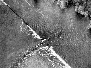
A levee breach or levee failure is a situation where a levee fails or is intentionally breached, causing the previously contained water to flood the land behind the levee.
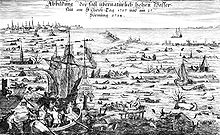
Saint Marcellus's flood or Grote Mandrenke was an intense extratropical cyclone, coinciding with a new moon, which swept across the British Isles, the Netherlands, northern Germany, and Denmark around 16 January 1362, causing at least 25,000 deaths. The storm tide is also called the "Second St. Marcellus flood" because it peaked on 16 January, the feast day of St. Marcellus. A previous "First St. Marcellus flood" drowned 36,000 people along the coasts of West Friesland and Groningen on 16 January 1219.

St. Lucia's flood (Sint-Luciavloed) was a storm tide that affected the Netherlands and Northern Germany on 13/14 December 1287 (OS), St. Lucia Day and the day after, killing approximately 50,000 to 80,000 people in one of the largest floods in recorded history.

Flood control is an important issue for the Netherlands, as due to its low elevation, approximately two thirds of its area is vulnerable to flooding, while the country is densely populated. Natural sand dunes and constructed dikes, dams, and floodgates provide defense against storm surges from the sea. River dikes prevent flooding from water flowing into the country by the major rivers Rhine and Meuse, while a complicated system of drainage ditches, canals, and pumping stations keep the low-lying parts dry for habitation and agriculture. Water control boards are the independent local government bodies responsible for maintaining this system.

Cyclone Tilo was a European windstorm which affected northern and western Europe in early November 2007. Combining with the remnants of Hurricane Noel, Tilo's storm surge led to the North Sea flood of 2007, affecting the coastlines of the Netherlands, the United Kingdom, Germany, Denmark, Norway and Belgium, starting on the night of 8–9 November 2007.
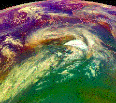
European windstorms are powerful extratropical cyclones which form as cyclonic windstorms associated with areas of low atmospheric pressure. They can occur throughout the year, but are most frequent between October and March, with peak intensity in the winter months. Deep areas of low pressure are common over the North Atlantic, and occasionally start as nor'easters off the New England coast. They frequently track across the North Atlantic Ocean towards the north of Scotland and into the Norwegian Sea, which generally minimizes the impact to inland areas; however, if the track is further south, it may cause adverse weather conditions across Central Europe, Northern Europe and especially Western Europe. The countries most commonly affected include the United Kingdom, Ireland, the Netherlands, Norway, Germany, the Faroe Islands and Iceland.

The November 2011 Bering Sea cyclone was one of the most powerful extratropical cyclones to affect Alaska on record. On November 8, the National Weather Service (NWS) began issuing severe weather warnings, saying that this was a near-record storm in the Bering Sea. It rapidly deepened from 973 mb (28.7 inHg) to 948 mb (28.0 inHg) in just 24 hours before bottoming out at 943 mbar, roughly comparable to a Category 3 or 4 hurricane. The storm had been deemed life-threatening by many people. The storm had a forward speed of at least 60 mph (97 km/h) before it had reached Alaska. The storm began affecting Alaska in the late hours of November 8, 2011. The highest gust recorded was 93 mph (150 km/h) on Little Diomede Island. One person was reported missing after being swept into the Bering Sea, and he was later pronounced dead.

Cyclone Andrea was an intense European windstorm that affected western and central Europe in early January 2012.
The Gale of January 1976, widely known as the "Capella" storm in Germany and the Ruisbroek flood in Belgium, was one in a series of extratropical cyclones and storm surges, which occurred over January 1976. The gale of 2–5 January 1976 resulted in severe wind damage across western and central Europe and coastal flooding around the southern North Sea coasts. At the time, this was the most severe storm of the century over the British Isles. Total fatalities reached 82 across Europe, although a figure of 100 is given by the World Meteorological Organization. Of these 24 were reported in Britain and 4 in Ireland. Overall losses of US$1.3 billion were incurred, with insured losses standing at US$500 million (1976).

The North Sea flood of 1978 was a storm surge which occurred over 11–12 January causing extensive coastal flooding and considerable damage on the east coast of England between the Humber and Kent. Higher water levels were reached than during the devastating North Sea flood of 1953 from North Shields to King's Lynn, but values were lower towards the Thames. Locally severe flooding occurred in Lincolnshire, The Wash, north Norfolk and Kent. Improvements in flood protection following the devastating flood of 1953 meant that the catastrophic losses seen during that storm were not repeated. The storm caused severe damage to many piers along the east coast of England.

Cyclone Xaver, also known as the North Sea flood or tidal surge of 2013, was a winter storm that affected northern Europe. Force 12 winds and heavy snowfall were predicted along the storm's path, and there were warnings of a significant risk of storm surge leading to coastal flooding along the coasts of the North and Irish Seas.

Cyclone Anne was a European windstorm which caused €75 million in damage across western Europe in early January 2014, followed days later by Cyclone Christina.

The 2013–2014 United Kingdom winter floods saw areas of Ireland and the United Kingdom inundated following severe storms. The south of England saw heavy rainfalls associated with these storms which caused widespread flooding, power cuts and major disruptions to transport. Economically, the worst affected areas were Somerset, Devon, Dorset and Cornwall in the south west and the Thames Valley in the south east.