Territorial claims in the Arctic

Last updated

Arctic topography and bathymetry IBCAO betamap.jpg
Arctic topography and bathymetry

The Arctic consists of land, internal waters, territorial seas, exclusive economic zones (EEZs) and international waters above the Arctic Circle (66 degrees 33 minutes North latitude). All land, internal waters, territorial seas and EEZs in the Arctic are under the jurisdiction of one of the eight Arctic coastal states: Canada, Denmark (via Greenland), Finland, Iceland, Norway, Russia, Sweden and the United States. [1] International law regulates this area as with other portions of Earth.

Contents

Under international law, the North Pole and the region of the Arctic Ocean surrounding it are not owned by any country. The five surrounding Arctic countries are limited to a territorial sea of 12 nautical miles (22 km; 14 mi) and an exclusive economic zone (EEZ) of 200 nautical miles (370 km; 230 mi) adjacent to their coasts measured from declared baselines filed with the UN. The waters beyond the territorial seas and EEZs, that is, beyond 200 nautical miles (370 km; 230 mi) from the coastal states' baselines, are considered the "high seas" (i.e. international waters). The waters and sea bottom that is not confirmed to be extended continental shelf beyond the exclusive economic zones are considered to be the "heritage of all mankind." Fisheries in these waters can only be limited by international treaty and exploration and exploitation of mineral resources on and below the seabed in these areas is administered by the UN International Seabed Authority.

Upon ratification of the United Nations Convention on the Law of the Sea (UNCLOS), a country has a ten-year period to make claims to an extended continental shelf which, if validated, gives it exclusive rights to resources on or below the seabed of that extended shelf area. [2] Norway, Russia, Canada, and Denmark launched projects to provide a basis for seabed claims on extended continental shelves beyond their exclusive economic zones. [3] The United States has signed, but not yet ratified the UNCLOS. [4] [5]

The status of certain portions of the Arctic sea region is in dispute for various reasons. Canada, Denmark, Norway, Russia, and the United States all regard parts of the Arctic seas as national waters (territorial waters out to 12 nautical miles (22 km)) or internal waters. There also are disputes regarding what passages constitute international seaways and rights to passage along them. There was one single disputed piece of land in the Arctic—Hans Island—which was disputed until 2022 between Canada and Denmark because of its location in the middle of a strait.

North Pole and the Arctic Ocean

National sectors: 1925–2005

In 1925, based upon the Sector Principle, Canada became the first country to extend its maritime boundaries northward to the North Pole, at least on paper, between 60°W and 141°W longitude, a claim that is not universally recognized (there are 415 nmi (769 km; 478 mi) of ocean between the Pole and Canada's northernmost land point). [6] On April 15 the following year, the Presidium of the Supreme Soviet of the USSR declared the territory between two lines (32°04′35″E to 168°49′30″W [7] ) drawn from west of Murmansk to the North Pole and from the eastern Chukchi Peninsula to the North Pole to be Soviet territory. Norway (5°E to 35°E) made similar sector claims, as did the United States (170°W to 141°W), but that sector contained only a few islands, so the claim was not pressed. Denmark's sovereignty over all of Greenland was recognized by the United States in 1916 and by an international court in 1933. Denmark could also conceivably claim an Arctic sector (60°W to 10°W). [6]

In the context of the Cold War, Canada sent Inuit families to the far north in the High Arctic relocation, partly to establish territoriality. [8] The Canadian monarch, Queen Elizabeth II, accompanied by the Duke of Edinburgh, Prince Charles, and Princess Anne, undertook in 1970 a tour of Northern Canada, in part to demonstrate to an unconvinced American government and the Soviet Union that Canada had certain claim to its Arctic territories, which were strategic during the Cold War. [9] In addition, Canada claims the water within the Canadian Arctic Archipelago as its own internal waters. The United States is one of the countries which does not recognize Canada's, or any other countries', Arctic archipelagic water claims and has allegedly sent nuclear submarines under the ice near Canadian islands without requesting permission. [10]

Until 1999, the geographic North Pole (a non-dimensional dot) and the major part of the Arctic Ocean had been generally considered to comprise international space, including both the waters and the sea bottom. However, the adoption of the United Nations Convention on the Law of the Sea (UNCLOS) has prescribed a process which prompted several countries to submit claims or to reinforce pre-existing claims to portions of the seabed of the polar region. [11]

Extended continental shelf claims: 2006–present

Overview

As defined by the UNCLOS, states have ten years from the date of ratification to make claims to an extended continental shelf. They must present to the Commission on the Limits of the Continental Shelf, a UN body, geological evidence that their shelf effectively extends beyond the 200 nautical miles limit. The Commission does not define borders but merely judges the scientific validity of assertions and it is up to countries with rightful but overlapping claims to come to a settlement. On this basis, four of the five states fronting the Arctic Ocean – Canada, Denmark, Norway, and the Russian Federation – must have made any desired claims by 2013, 2014, 2006, and 2007 respectively. Since the U.S. has yet to ratify the UNCLOS, the date for its submission is undetermined at this time. [12]

Claims to extended continental shelves, if deemed valid, give the claimant state exclusive rights to the sea bottom and resources below the bottom. Valid extended continental shelf claims do not and cannot extend a state's Exclusive Economic Zone (EEZ) since the EEZ is determined solely by drawing a 200-nautical-mile (370 km) line using territorial sea baselines as their starting point. Press reports often confuse the facts and assert that extended continental shelf claims expand a state's EEZ thereby giving a state exclusive rights to resources not only on the sea bottom or below it, but also to those in the water column above it. The Arctic chart prepared by Durham University explicitly illustrates the extent of the uncontested Exclusive Economic Zones of the five states bordering the Arctic Ocean, and also the relatively small expanse of remaining "high seas" or totally international waters at the very North of the planet. [13]

Specific nations

Canada
External image
Searchtool.svg Map identifying baselines and territorial sea in the Canadian Arctic islands; [14] retrieved 25 March 2017

Canada ratified UNCLOS on 7 November 2003 and had through 2013 to file its claim to an extended continental shelf. As of December 2013, Canada had announced that it would file a claim which includes the North Pole. [15] Canada planned to submit their claim to a portion of the Arctic continental shelf in 2018. [16]

In response to the Russian Arktika 2007 expedition, Canada's Foreign Affairs Minister, Peter MacKay, said "[t]his is posturing. This is the true North, strong and free, and they're fooling themselves if they think dropping a flag on the ocean floor is going to change anything... This isn't the 14th or 15th century." [17] [18] In response, Sergey Lavrov, the Russian Minister of Foreign Affairs, stated "[w]hen pioneers reach a point hitherto unexplored by anybody, it is customary to leave flags there. Such was the case on the Moon, by the way... [W]e from the outset said that this expedition was part of the big work being carried out under the UN Convention on the Law of the Sea, within the international authority where Russia's claim to submerged ridges which we believe to be an extension of our shelf is being considered. We know that this has to be proved. The ground samples that were taken will serve the work to prepare that evidence." [19]

On 25 September 2007, Prime Minister Stephen Harper said he was assured by Russian President Vladimir Putin that neither offence nor "violation of international understanding or any Canadian sovereignty" was intended. [20] [21] Harper promised to defend Canada's claimed sovereignty by building and operating up to eight Arctic patrol ships, a new army training centre in Resolute Bay, and the refurbishing of an existing deepwater port at a former mining site in Nanisivik. [22]

Denmark
External images
Searchtool.svg Area of the Greenland continental shelf in the Arctic Ocean beyond 200-nautical-mile zone  – borders of the 200 mile zone are marked in red, territory claimed by Denmark is shaded
Searchtool.svg Delineation points

Denmark ratified UNCLOS on 16 November 2004 and had through 2014 to file a claim to an extended continental shelf.

The Kingdom of Denmark simultaneously declared that ratifying UNCLOS did not change Denmark's position that the Danish straits including the Great Belt, the Little Belt, and the Danish part of Øresund, formed on the foundation of the Copenhagen Treaty of 1857 are legally Danish territory, and – as set out in the treaty section of the United Nations Office of Legal Affairs  – this should remain so. [23] Consequently, Denmark considers the Copenhagen Convention to apply solely to the waterways through Denmark proper and not the North Atlantic.

Greenland, an autonomous territory within the Kingdom of Denmark, has the nearest coastline to the North Pole, and Denmark argues that the Lomonosov Ridge is in fact an extension of Greenland. [24] [ unreliable source? ] Danish project included LORITA-1 expedition in April–May 2006 [25] and included tectonic research during LOMROG expedition, which were part of the 2007–2008 International Polar Year program. [26] It comprised the Swedish icebreaker Oden and Russian nuclear icebreaker NS 50 Let Pobedy. The latter led the expedition through the ice fields to the research location. [27] Further efforts at geological study in the region were carried out by the LOMROG II expedition, which took place in 2009, and the LOMROG III expedition, launched in 2012. [28] [29]

On 14 December 2014 Denmark claimed an area of 895,000 km2 (346,000 sq mi) extending from Greenland past the North Pole to the limits of the Russian Exclusive Economic Zone. Unlike the Russian claim which is generally limited to the Russia sector of the Arctic, the Danish Claim extends across the North Pole and into Russia's sector. [30] [31] [32] [33]

Norway

Norway ratified the UNCLOS on 24 June 1996 and had through 2006 to file a claim to an extended continental shelf.

On November 27, 2006, Norway made an official submission into the UN Commission on the Limits of the Continental Shelf in accordance with the United Nations Convention on the Law of the Sea (article 76, paragraph 8). There are provided arguments to extend the Norwegian seabed claim beyond the 200 nmi (370 km; 230 mi) EEZ in three areas of the northeastern Atlantic and the Arctic: the "Loop Hole" in the Barents Sea, the Western Nansen Basin in the Arctic Ocean, and the "Banana Hole" in the Norwegian Sea. The submission also states that an additional submission for continental shelf limits in other areas may be posted later. [34]

Norway and Russia have ratified an agreement on the Barents Sea, ending a 40-year demarcation dispute. [35] [36]

Russia

Russia ratified the UNCLOS in 1997 and had through 2007 to file a claim to an extended continental shelf.

The Russian Federation is claiming a large extended continental shelf as far as the North Pole based on the Lomonosov Ridge and Mendeleyev Ridges within their Arctic sector. Moscow believes the eastern Lomonosov Ridge and the Mendeleyev Ridge are an extension of the Siberian continental shelf. Until Denmark filed its claim, the Russian claim did not cross the Russia-US Arctic sector demarcation line, nor did it extend into the Arctic sector of any other Arctic coastal state.

On December 20, 2001, Russia made an official submission into the UN Commission on the Limits of the Continental Shelf in accordance with the United Nations Convention on the Law of the Sea (article 76, paragraph 8). In the document it is proposed to establish the outer limits of the continental shelf of Russia beyond the 200-nautical-mile (370 km) Exclusive Economic Zone, but within the Russian Arctic sector. [37] The territory claimed by Russia in the submission is a large portion of the Arctic within its sector, extending to but not beyond the geographic North Pole. [38] One of the arguments was a statement that Lomonosov Ridge, an underwater mountain ridge passing near the Pole, and Mendeleev Ridge on the Russian side of the Pole are extensions of the Eurasian continent. In 2002 the UN Commission neither rejected nor accepted the Russian proposal, recommending additional research. [37]

MIR submersible Mir front.jpg
MIR submersible

On August 2, 2007, a Russian expedition called Arktika 2007, composed of six explorers led by Artur Chilingarov, employing MIR submersibles, for the first time in history descended to the seabed at the North Pole. There they planted a Russian flag and took water and soil samples for analysis, continuing a mission to provide additional evidence related to the Russian extended continental shelf claim including the mineral riches of the Arctic. [39] This was part of the ongoing 2007 Russian North Pole expedition within the program of the 2007–2008 International Polar Year.

The expedition aimed to establish that the eastern section of seabed passing close to the Pole, known as the Lomonosov and Mendeleyev Ridges, is in fact an extension of Russia's landmass. The expedition came as several countries are trying to extend their rights over sections of the Arctic Ocean floor. Both Norway and Denmark are carrying out surveys to this end. Vladimir Putin made a speech on a nuclear icebreaker on 3 May 2007, urging greater efforts to secure Russia's "strategic, economic, scientific and defense interests" in the Arctic. [40]

In mid-September 2007, Russia's Natural Resources Ministry issued a statement:

Preliminary results of an analysis of the earth crust model examined by the Arktika 2007 expedition, obtained on September 20, have confirmed that the crust structure of the Lomonosov Ridge corresponds to the world analogues of the continental crust, and it is therefore part of the Russian Federation's adjacent continental shelf. [41]

Viktor Posyolov, an official with Russia's Agency for Management of Mineral Resources:

With a high degree of likelihood, Russia will be able to increase its continental shelf by 1.2 million square kilometers [460,000 square miles] with potential hydrocarbon reserves of not less than 9,000 to 10,000 billion tonnes of conventional fuel beyond the 200-mile (320 km) [322 kilometer] economic zone in the Arctic Ocean [42]

On August 4, 2015, Russia submitted additional data in support of its bid, containing new arguments based on "ample scientific data collected in years of Arctic research", for territories in the Arctic to the United Nations. Through this bid, Russia is claiming 1.2 million square kilometers (over 463,000 square miles) of Arctic sea shelf extending more than 350 nautical miles (about 650 kilometers) from the shore. [43] In February 2016 additional data was submitted by Russian Minister of Natural Resources and Environment Sergey Donskoy. After the expedition "Arktika 2007" Russian researchers collected new data reinforcing Russia's claim to part of the sea bottom beyond its uncontested 200-mile Exclusive Economic Zone (EEZ) within its Arctic sector, the North Pole area included. On August 9, 2016, the UN Commission on the Limits of the Continental Shelf began its review of the submission.

In 2021, the Russian Federation submitted several addenda to the CLCS extending the area claimed as part of its extended continental shelf. One submission extended its shelf claim across the Lomonosov Ridge up to the outer limit of Canada and Denmark's EEZ. This area overlaps completely with Danish and Canadian claims. Moscow also extended its shelf on the Gakkel Ridge, part of which overlaps with Danish claims. [44]

United States

As of 2023, the United States has not ratified the UN Convention on the Law of the Sea (UNCLOS). However, the United States points out that a coastal state's right to an extended continental shelf is well established in customary international law, so US rights do not depend on joining UNCLOS or making submissions to the CLCS. [45]

In August 2007, an American Coast Guard icebreaker, the USCGC Healy, headed to the Arctic Ocean to map the sea floor off Alaska. Larry Mayer, director of the Center for Coastal and Ocean Mapping at the University of New Hampshire, stated the trip had been planned for months, having nothing to do with the Russians planting their flag. The purpose of the mapping work aboard the Healy is to determine the extent of the US continental shelf north of Alaska.

Future

It was stated by the Intergovernmental Panel on Climate Change on March 25, 2007, that riches are awaiting the shipping industry due to Arctic climate change. This economic sector could be transformed similar to the way the Middle East was by the Suez Canal in the 19th century. There will be a race among nations for oil, fish, diamonds and shipping routes, accelerated by the impact of global warming. [46]

However, much research commentary since 2008 has thrown cold water on narratives that the Arctic will experience a rush for resources that could lead to conflict between states.

The potential value of the North Pole and the surrounding area resides not so much in shipping itself but in the possibility that lucrative petroleum and natural gas reserves exist below the sea floor. Such reserves are known to exist under the Barents, Kara, and Beaufort Seas. However, the vast majority of the Arctic known to contain gas and oil resources is already within uncontested EEZs. While these EEZs leave much of the Central Arctic Ocean high seas, Canada, Russia, Denmark (via Greenland), and Norway have all announced extended continental shelf claims that cover almost the entire Arctic seabed. [47] This would mean that legal rights to oil, gas, and other resources in and on the seabed would belong exclusively to the Arctic coastal states, which would have sole jurisdiction to manage their resources.

On September 14, 2007, the European Space Agency reported ice loss had opened up the Northwest Passage "for the first time since records began in 1978", and the extreme loss in 2007 rendered the passage "fully navigable". [48] [49] Further exploration for petroleum reserves elsewhere in the Arctic may now become more feasible, and the passage may become a regular channel of international shipping and commerce if Canada is not able to enforce its claim to it. [50]

Foreign Ministers and other officials representing Canada, Denmark, Norway, Russia, and the United States met in Ilulissat, Greenland in May 2008, at the Arctic Ocean Conference and announced the Ilulissat Declaration. Among other things the declaration stated that any demarcation issues in the Arctic should be resolved on a bilateral basis between contesting parties. [51] [52]

Hans Island

Map of part of Kennedy Channel, with the formerly disputed island Nares strait border (Kennedy channel).png
Map of part of Kennedy Channel, with the formerly disputed island

Hans Island is situated in the Nares Strait, a waterway that runs between Ellesmere Island (the northernmost part of Nunavut, Canada) and Greenland. The small uninhabited island, sized 1.3 km2 (0.5 sq mi), was named for Greenlandic Arctic traveller Hans Hendrik.

In 1973, Canada and Denmark negotiated the geographic coordinates of the continental shelf, and settled on a delimitation treaty that was ratified by the United Nations on December 17, 1973, and has been in force since March 13, 1974. The treaty lists 127 points (by latitude and longitude) from Davis Strait to the end of Robeson Channel, where Nares Strait runs into Lincoln Sea; the border is defined by geodesic lines between these points. The treaty does not, however, draw a line from point 122 ( 80°49′2″N66°29′0″W / 80.81722°N 66.48333°W / 80.81722; -66.48333 ) to point 123 ( 80°49′8″N66°26′3″W / 80.81889°N 66.43417°W / 80.81889; -66.43417 )—a distance of 875 m (0.54 mi). Hans Island is situated in the centre of this area.

Danish flags were planted on Hans Island in 1984, 1988, 1995 and 2003. The Canadian government formally protested these actions. In July 2005, former Canadian defence minister Bill Graham made an unannounced stop on Hans Island during a trip to the Arctic; this launched yet another diplomatic quarrel between the governments, and a truce was called that September.

Canada had claimed Hans Island was clearly in its territory, as topographic maps originally used in 1967 to determine the island's coordinates clearly showed the entire island on Canada's side of the delimitation line. However, federal officials reviewed the latest satellite imagery in July 2007, and conceded that the line went roughly through the middle of the island. This left ownership of the island disputed, with claims over fishing grounds and future access to the Northwest Passage possibly at stake as well. [53]

As of April 2012, the governments of both countries were in negotiations which ultimately resulted in the island being split almost precisely in half. [54] The negotiations ended in November 2012 and gave a more exact border description, but did not solve the dispute over Hans Island. One possible resolution was to treat the island as a condominium. [55]

In 2022, Canada and Denmark resolved the dispute, establishing a land border through Hans Island. [56]

Beaufort Sea

The cross-hatched wedge-shaped region in the east is claimed by both Canada and the United States Arctic management area and disputed waters.jpg
The cross-hatched wedge-shaped region in the east is claimed by both Canada and the United States
Map including the border area Operational Navigation Chart C-9, 6th edition.jpg
Map including the border area

There is an ongoing dispute involving a wedge-shaped slice on the International Boundary in the Beaufort Sea, between the Canadian territory of Yukon and the American state of Alaska. [57]

The Canadian position is that the maritime boundary should extend the land boundary in a straight line, following the natural prolongation principle. The American position is that the maritime boundary should extend along a path equidistant from the coasts of the two nations, following the equidistance principle. The disputed area may hold significant hydrocarbon reserves. The U.S. has already leased eight plots of the terrain below the water to search for and possibly bring to market oil reserves that may exist there. Canada has protested diplomatically in response. [58] The boundary could also effect the delimitation of the extended continental shelf in the Beaufort and Chukchi Seas: Ironically, each country's position within 200 nautical miles produces a line that favors the other state beyond 200 nautical miles.

No settlement has been reached to date. [57]

On August 20, 2009 United States Secretary of Commerce Gary Locke announced a moratorium on fishing the Beaufort Sea north of Alaska, including the disputed waters. [59] [60] Randy Boswell, of Canada.com wrote that the disputed area covered a 21,436 square kilometres (8,276 sq mi) section of the Beaufort Sea (smaller than Israel, larger than El Salvador). He wrote that Canada had filed a "diplomatic note" with the United States in April when the US first announced plans for the moratorium.

Northwest Passage

Northwest Passage routes Northwest passage.jpg
Northwest Passage routes

The legal status of the Northwest Passage is disputed: Canada considers it to be part of its historic internal waters. [61] The United States and most maritime nations [62] consider them to be an international strait, [63] which means that foreign vessels have right of "transit passage". [64] In such a regime, Canada would have the right to enact fishing and environmental regulation, and fiscal and smuggling laws, as well as laws intended for the safety of shipping, but not the right to close the passage. [65] In addition, the environmental regulations allowed under the UNCLOS are not as robust as those allowed if the Northwest Passage is part of Canada's internal waters. [66]

Northeast Passage

Russia considers portions of the Northern Sea Route, which encompasses only navigational routes through waters within Russia's Arctic EEZ east from Novaya Zemlya to the Bering Strait, to pass through Russian territorial and internal waters in the Kara, Vilkitskiy, and Sannikov Straits.

Arctic territories

Canada

Denmark

Iceland

Norway

Russia

United States

Others

See also

Related Research Articles

<span class="mw-page-title-main">Norwegian Sea</span> Marginal sea of the Arctic or Atlantic Ocean, northwest of Norway

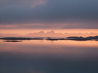
The Norwegian Sea is a marginal sea, grouped with either the Atlantic Ocean or the Arctic Ocean, northwest of Norway between the North Sea and the Greenland Sea, adjoining the Barents Sea to the northeast. In the southwest, it is separated from the Atlantic Ocean by a submarine ridge running between Iceland and the Faroe Islands. To the north, the Jan Mayen Ridge separates it from the Greenland Sea.

<span class="mw-page-title-main">United Nations Convention on the Law of the Sea</span> International maritime law

The United Nations Convention on the Law of the Sea (UNCLOS), also called the Law of the Sea Convention or the Law of the Sea Treaty, is an international agreement that establishes a legal framework for all marine and maritime activities. As of May 2023, 168 countries and the European Union are parties.

<span class="mw-page-title-main">Arctic</span> Polar region of the Earths northern hemisphere

The Arctic is a polar region located at the northernmost part of Earth. The Arctic region, from the IERS Reference Meridian travelling east, consists of parts of northern Norway, northernmost Sweden, northern Finland, Russia, the United States (Alaska), Canada, Danish Realm (Greenland), and northern Iceland, along with the Arctic Ocean and adjacent seas. Land within the Arctic region has seasonally varying snow and ice cover, with predominantly treeless permafrost under the tundra. Arctic seas contain seasonal sea ice in many places.

<span class="mw-page-title-main">Hans Island</span> Island shared by Canada and Greenland, Denmark

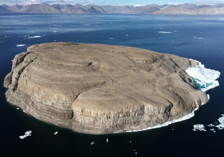
Hans Island is an island in the centre of the Kennedy Channel of Nares Strait in the high Arctic region, split between the Canadian territory of Nunavut and the Danish autonomous territory of Greenland. The island itself is barren and uninhabited with an area of 130 hectares, measuring 1,290 by 1,199 metres, and a maximum elevation of 168.17 m (551.7 ft). Its location in the strait that separates Ellesmere Island of Canada from northern Greenland was for years a border dispute, the so-called Whisky War between the two countries of Canada and Denmark. Hans Island is the smallest of three islands in Kennedy Channel off the Washington Land coast; the others are Franklin Island and Crozier Island. The strait at this point is 35 km (22 mi) wide, placing the island within the territorial waters of both Canada and Denmark (Greenland). A 1,280-metre-long (4,200 ft) border traverses the island.

<span class="mw-page-title-main">International waters</span> Water outside of national jurisdiction

The terms international waters or transboundary waters apply where any of the following types of bodies of water transcend international boundaries: oceans, large marine ecosystems, enclosed or semi-enclosed regional seas and estuaries, rivers, lakes, groundwater systems (aquifers), and wetlands.

<span class="mw-page-title-main">Territorial waters</span> Coastal waters that are part of a sovereign states sovereign territory

Territorial waters are informally an area of water where a sovereign state has jurisdiction, including internal waters, the territorial sea, the contiguous zone, the exclusive economic zone, and potentially the extended continental shelf. In a narrower sense, the term is often used as a synonym for the territorial sea.

<span class="mw-page-title-main">Exclusive economic zone</span> Adjacent sea zone in which a state has special rights

An exclusive economic zone (EEZ), as prescribed by the 1982 United Nations Convention on the Law of the Sea, is an area of the sea in which a sovereign state has exclusive rights regarding the exploration and use of marine resources, including energy production from water and wind. EEZ does not define the ownership of any maritime features within the EEZ.

<span class="mw-page-title-main">Lincoln Sea</span> Body of water in the Arctic Ocean

Lincoln Sea is a body of water in the Arctic Ocean, stretching from Cape Columbia, Canada, in the west to Cape Morris Jesup, Greenland, in the east. The northern limit is defined as the great circle line between those two headlands. It is covered with sea ice throughout the year, the thickest sea ice in the Arctic Ocean, which can be up to 15 m (49 ft) thick. Water depths range from 100 m (330 ft) to 300 m (980 ft). Water and ice from Lincoln Sea empty into Robeson Channel, the northernmost part of Nares Strait, most of the time.

<span class="mw-page-title-main">Lomonosov Ridge</span> Underwater ridge of continental crust in the Arctic Ocean

The Lomonosov Ridge is an unusual underwater ridge of continental crust in the Arctic Ocean. It spans 1,800 kilometres (1,100 mi) between the New Siberian Islands over the central part of the ocean to Ellesmere Island of the Canadian Arctic Archipelago. The ridge divides the Arctic Basin into the Eurasian Basin and the Amerasian Basin. The width of the Lomonosov Ridge varies from 60 to 200 kilometres. It rises 3,300 to 3,700 metres above the 4,200-metre (13,800 ft) deep seabed. The minimum depth of the ocean above the ridge is less than 400 metres (1,300 ft). Slopes of the ridge are relatively steep, broken up by canyons, and covered with layers of silt. It is an aseismic ridge.

<span class="mw-page-title-main">Arctic Council</span> Intergovernmental forum for the Arctic

The Arctic Council is a high-level intergovernmental forum that addresses issues faced by the Arctic governments and the indigenous people of the Arctic region. At present, eight countries exercise sovereignty over the lands within the Arctic Circle, and these constitute the member states of the council: Canada; Denmark; Finland; Iceland; Norway; Russia; Sweden; and the United States. Other countries or national groups can be admitted as observer states, while organizations representing the concerns of indigenous peoples can be admitted as indigenous permanent participants.

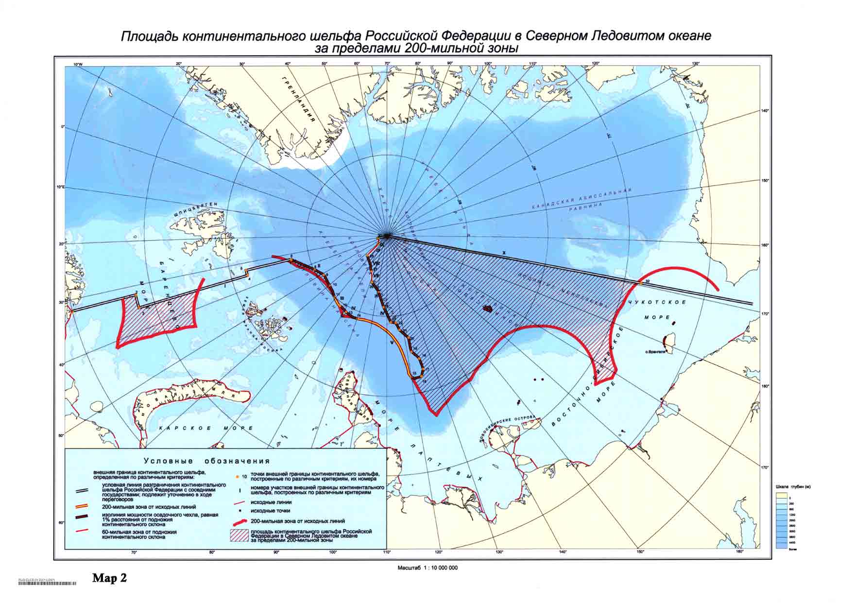
The continental shelf of Russia or the Russian continental shelf is the continental shelf adjacent to the Russian Federation. Geologically, the extent of the shelf is defined as the entirety of the continental shelves adjacent to Russia's coasts. In international law, however, the United Nations Convention on the Law of the Sea more narrowly defines the extent of the shelf as the seabed and subsoil of the submarine areas over which a state exercises sovereign rights.

<span class="mw-page-title-main">Arktika 2007</span> Russian expedition involving a crewed descent to the ocean bottom at the North Pole

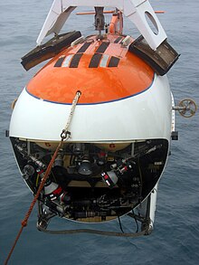
Arktika 2007 was a 2007 expedition in which Russia performed the first ever crewed descent to the ocean bottom at the North Pole, as part of research related to the 2001 Russian territorial claim, one of many territorial claims in the Arctic, made possible, in part, because of Arctic shrinkage. As well as dropping a titanium tube containing the Russian flag, the submersibles collected specimens of Arctic flora and fauna and apparently recorded video of the dives. The "North Pole-35" manned drifting ice station was established.

<span class="mw-page-title-main">Arctic Ocean</span> Ocean in the north polar region

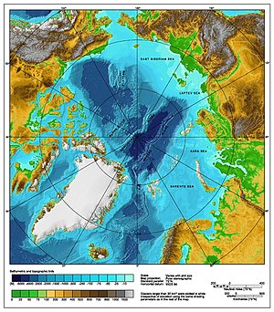
The Arctic Ocean is the smallest and shallowest of the world's five major oceans. It spans an area of approximately 14,060,000 km2 (5,430,000 sq mi) and is known as one of the coldest of oceans. The International Hydrographic Organization (IHO) recognizes it as an ocean, although some oceanographers call it the Arctic Mediterranean Sea. It has also been described as an estuary of the Atlantic Ocean. It is also seen as the northernmost part of the all-encompassing World Ocean.

<span class="mw-page-title-main">Arctic cooperation and politics</span> Between the eight Arctic nations

Arctic cooperation and politics are partially coordinated via the Arctic Council, composed of the eight Arctic nations: the United States, Canada, Iceland, Norway, Sweden, Finland, Russia, and Denmark with Greenland and the Faroe Islands. The dominant governmental power in Arctic policy resides within the executive offices, legislative bodies, and implementing agencies of the eight Arctic nations, and to a lesser extent other nations, such as United Kingdom, Germany, European Union and China. NGOs and academia play a large part in Arctic policy. Also important are intergovernmental bodies such as the United Nations and NATO.

<span class="mw-page-title-main">Arctic policy of Russia</span> Russia and the Arctic

The Arctic policy of Russia is the domestic and foreign policy of the Russian Federation with respect to the Russian region of the Arctic. The Russian region of the Arctic is defined in the "Russian Arctic Policy" as all Russian possessions located north of the Arctic Circle. Approximately one-fifth of Russia's landmass is north of the Arctic Circle. Russia is one of five littoral states bordering the Arctic Ocean. As of 2010, out of 4 million inhabitants of the Arctic, roughly 2 million lived in arctic Russia, making it the largest arctic country by population. However, in recent years Russia's Arctic population has been declining at an excessive rate.

<span class="mw-page-title-main">Arctic policy of the Kingdom of Denmark</span> Danish foreign policy

The Arctic Policy of the Kingdom of Denmark defines the Kingdom's foreign relations and policies with other Arctic countries, and the Kingdom's strategy for the Arctic on issues occurring within the geographic boundaries of "the Arctic" or related to the Arctic or its peoples. In order to clearly understand the Danish geopolitical importance of the Arctic, it is necessary to mention Denmark's territorial claims in areas beyond its exclusive EEZ in areas around the Faroe Islands and north of Greenland covering parts of the North Pole, which is also claimed by Russia.

<span class="mw-page-title-main">Chukchi Plateau</span> A large subsea formation extending north from the Alaskan margin into the Arctic Ocean

The Chukchi Plateau or Chukchi Cap is a large subsea formation extending north from the Alaskan margin into the Arctic Ocean. The ridge is normally covered by ice year-round, and reaches an approximate bathymetric prominence of 3,400 m with its highest point at 246 m below sea level. As a subsea ridge extending from the continental shelf of the United States north of Alaska, the Chukchi Plateau is an important feature in maritime law of the Arctic Ocean and has been the subject of significant geographic research. The ridge has been extensively mapped by the USCGC Healy, and by the Canadian icebreaker CCGS Louis S. St-Laurent in 2011 and RV Marcus Langseth, a National Science Foundation vessel operated by the Lamont–Doherty Earth Observatory of Columbia University.

<span class="mw-page-title-main">Rockall Bank dispute</span> Conflicting maritime claims

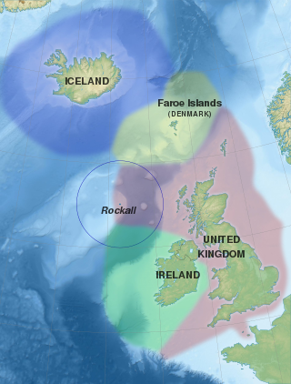
Several states have claimed interests over the sea bed adjoining Rockall, an uninhabitable granite islet which is located within the exclusive economic zone (EEZ) of the United Kingdom. Ireland, Denmark, Iceland, and the United Kingdom have all made submissions to the commission set up under the United Nations Convention on the Law of the Sea (UNCLOS).

<span class="mw-page-title-main">Geopolitics of the Arctic</span> Area study of geopolitics on the Arctic region

Arctic geopolitics is the area study of geopolitics on the Arctic region. The study of geopolitics deals with the "inalienable relationship between geography and politics", as it investigates the effects of the Earth's geography on politics and international relations. Arctic geopolitics focuses on the inter-state relations in the Arctic, which is the northernmost polar region. It is composed of the Arctic Ocean and its adjacent seas, and is home to around four million people. The states in or bordering the Arctic are commonly referred to as the Arctic Eight, and are the United States, Canada, Russia, Finland, the Kingdom of Denmark (Greenland), Norway, Iceland and Sweden.

<span class="mw-page-title-main">Exclusive economic zone of Canada</span>

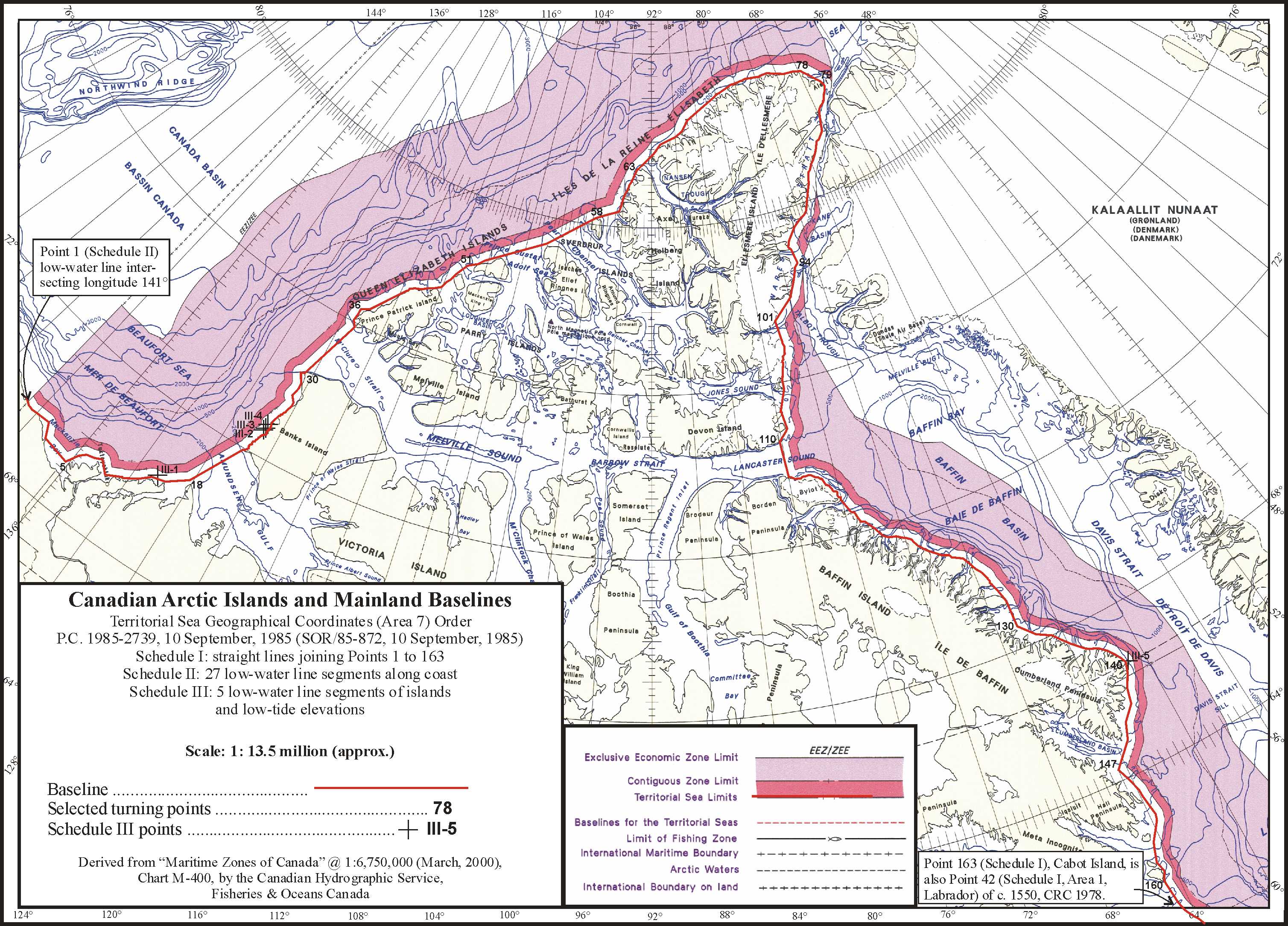
The exclusive economic zone of Canada is the area of the sea in which Canada has special rights regarding the exploration and use of marine resources, as prescribed by the 1982 United Nations Convention on the Law of the Sea.

References

  1. "Arctic Council".
  2. "United Nations Convention on the Law of the Sea (Annex 2, Article 4)" . Retrieved 2007-07-26.
  3. Archived August 8, 2007, at the Wayback Machine
  4. Drawbaugh, Kevin (October 31, 2007). "U.S. Senate panel backs Law of the Sea treaty". Reuter.
  5. "President's Statement on Advancing U.S. Interests in the World's Oceans". Georgewbush-whitehouse.archives.gov. 2007-05-15. Retrieved 2012-01-10.
  6. 1 2 T. E. M. McKitterick, "The Validity of Territorial and Other Claims in Polar Regions," Journal of Comparative Legislation and International Law, 3rd Ser., Vol. 21, No. 1. (1939), pp. 89–97.JSTOR   754556
  7. Sobranie Zakonov SSSR, 1926 (Russian)
  8. Dussault, René; Erasmus, George (1994). "The High Arctic Relocation- A Report on the 1953–55 Relocation (Royal Commission on Aboriginal Peoples)". Canadian Government Publishing. p. 190. Archived from the original on 2009-10-01.
  9. Davison, Janet (7 November 2014). "Princess Anne's Ottawa tour will honour 'everyday heroes'". Canadian Broadcasting Corporation. Retrieved 23 November 2014.
  10. Halloran, Richard (4 May 1987). "U.S. Suspicious Of Canada's Plan For Nuclear Subs". New York Times. Retrieved 25 November 2017.
  11. UN Convention on the Law of the Sea
  12. Lasserre, Frédéric (November 2011). "The Geopolitics of Arctic Passages and Continental Shelves" (PDF). Public Sector Digest.
  13. "Maritime jurisdiction and boundaries in the Arctic region" (PDF). International Boundaries Research Unit, Durham University. 2008-07-24.
  14. Territorial Sea Geographical Coordinates (Area 7) Order , SOR/85-872
  15. "Canada to claim north pole as its own". Associated Press in Toronto. The Guardian. December 9, 2013. Retrieved 10 December 2013.
  16. International, Radio Canada (3 May 2016). "Canada to submit its Arctic continental shelf claim in 2018". www.rcinet.ca. Retrieved 25 February 2017.
  17. Reynolds, Paul (2008-05-29). "Trying to head off an Arctic 'gold rush'". BBC News. Retrieved 2012-01-10.
  18. "Russia plants flag staking claim to Arctic region". Cbc.ca. 2007-08-02. Retrieved 2012-01-10.
  19. "Transcript of Remarks and Replies to Media Questions by Russian Minister of Foreign Affairs Sergey Lavrov at Joint Press Conference with Philippine Foreign Affairs Secretary A". Mid.ru. Retrieved 2012-01-10.
  20. Lackenbauer, P. Whitney; Morrisson, William; Poelzer, Greg (2008). Arctic Front: Defending Canada in the Far North. Thomas Allen Publishers. pp. 109–. ISBN   9780887628405 . Retrieved 2012-10-13.[ permanent dead link ]
  21. "A Conversation with Stephen Harper [Rush Transcript; Federal News Service] – Council on Foreign Relations". Cfr.org. Archived from the original on 2009-03-02. Retrieved 2012-01-10.
  22. Michael McCormack, "More than Words: Securitization and Policymaking in the Canadian Arctic under Stephen Harper," American Review of Canadian Studies (2020) 50#4 pp 436-460.
  23. "United Nations Oceans & Law of the Sea". 12 July 2011. Retrieved 2012-05-22.
  24. "Territorial claims – The Right Arctic". Arcticcontroversy.weebly.com. Retrieved 2015-05-31.
  25. Kontinentalsokkelprojektet. "LORITA-1 (Lomonosov Ridge Test of Appurtenance)". A76.dk. Archived from the original on 2009-03-26. Retrieved 2012-01-10.
  26. "LOMROG – Lomonosov Ridge off Greenland". Geo.su.se. Archived from the original on 2011-09-30. Retrieved 2012-01-10.
  27. Kontinentalsokkelprojektet. "LOMROG 2007 cruise with the Swedish icebreaker Oden north of Greenland". A76.dk. Archived from the original on 2009-04-13. Retrieved 2012-01-10.
  28. "Geologists to gather data for Danish North Pole claim". New Scientist.
  29. "LOMROG III expedition in 2012 with the Swedish icebreaker Oden". The Continental Shelf Project. Archived from the original on August 27, 2012. Retrieved August 1, 2012.
  30. "Submission by the Kingdom of Denmark" United Nations Convention on the Law of the Sea , 15 December 2014. Accessed: 15 December 2014.
  31. "The Northern Continental Shelf of Greenland (Executive Summary) Archived 2014-12-16 at the Wayback Machine " Geological Survey of Denmark and Greenland / Ministry of Climate, Energy and Building (Denmark) , November 2014. Accessed: 15 December 2014. Size: 52 pages in 6MB. UN mirror
  32. "Denmark challenges Russia and Canada over North Pole". BBC News. 15 December 2014. Retrieved 8 May 2015.
  33. Ramskov, Jens. "Derfor gør Danmark nu krav på Nordpolen" In English Ingeniøren , 15 December 2014. Accessed: 15 December 2014.
  34. "Continental Shelf – submission to the Commission by Norway". un.org. Retrieved 8 May 2015.
  35. "Evolution of Arctic Territorial Claims and Agreements: A Timeline (1903–Present) Archived 2016-01-21 at the Wayback Machine " Henry L. Stimson Center , 15 September 2013. Accessed: 17 December 2014.
  36. "Treaty on Maritime Delimitation and Cooperation in the Barents Sea and the Arctic Ocean" Norwegian Government, 15 September 2010.
  37. 1 2 "Continental Shelf – submission to the Commission by the Russian Federation". un.org. Retrieved 8 May 2015.
  38. Area of the continental shelf of the Russian Federation in the Arctic Ocean beyond 200-nautical-mile zone  – borders of the 200 nmi (370 km; 230 mi) zone are marked in red, territory claimed by Russia is shaded
  39. The Battle for the Next Energy Frontier: The Russian Polar Expedition and the Future of Arctic Hydrocarbons, by Shamil Yenikeyeff and Timothy Fenton Krysiek, Oxford Institute for Energy Studies, August 2007
  40. ITAR-TASS (English) 0602 GMT 03 May 2009
  41. "Lomonosov Ridge, Mendeleyev elevation part of Russia's shelf – report". Interfax Moscow. 2007-09-20. Archived from the original on May 25, 2011. Retrieved 2007-09-21.
  42. "Russia's Arctic Claim Backed By Rocks, Officials Say". News.nationalgeographic.com. 2010-10-28. Archived from the original on October 11, 2007. Retrieved 2012-01-10.
  43. "Russia to UN: We are claiming 463,000 square miles of the Arctic". Business Insider . Retrieved 2015-08-05.
  44. "Continental Shelf-submission to the Commission by the Russian Federation". United Nations . Retrieved 2023-01-02.
  45. "Frequently Asked Questions-U.S. Extended Continental Shelf Project". United States Department of State. n.d. Retrieved 2 January 2023.
  46. "The Big Melt: A Series About the Arctic and Climate Change From The New York Times". Archived from the original on August 28, 2007. Retrieved July 26, 2007.
  47. "Archived copy" (PDF). Archived from the original (PDF) on August 8, 2008. Retrieved February 16, 2011.{{cite web}}: CS1 maint: archived copy as title (link)
  48. "Satellites witness lowest Arctic ice coverage in history" . Retrieved 2007-09-14.
  49. "Warming 'opens Northwest Passage'". BBC News. 2007-09-14. Retrieved 2007-09-14.
  50. "The Scramble for the Arctic: The United Nations Convention on the Law of the Seas and Extending Seabed Claims". Paper presented at the annual meeting of the Midwest Political Science Association 67th Annual National Conference, The Palmer House Hilton, Chicago, IL Online. 2009-04-02. Retrieved 2009-11-09.
  51. "Conference in Ilulissat, Greenland: Landmark political declaration on the future of the Arctic". Ministry of Foreign Affairs of Denmark. 2008-05-28. Archived from the original on 2008-06-15. Retrieved 2008-06-06.
  52. "The Ilulissat Declaration" (PDF). um.dk. 2008-05-28. Archived from the original (PDF) on 2008-06-26. Retrieved 2008-06-06.
  53. "Satellite imagery moves Hans Island boundary: report". Canadian Press. July 26, 2007. Retrieved 2007-08-27.
  54. "New proposal would see Hans Island split equally between Canada and Denmark". National Post. April 11, 2012. Retrieved 2012-05-05.
  55. Weber, Bob (2015-11-15). "Canada, Denmark should turn Hans Island into a condominium: academics". CBC News.
  56. "Boundary dispute Backgrounder". Global Affairs Canada. 2022. Retrieved 14 June 2022.
  57. 1 2 "Transnational Issues CIA World Fact Book". CIA. Retrieved 2012-01-10.
  58. Sea Changes Archived June 13, 2007, at the Wayback Machine
  59. "Secretary of Commerce approves fisheries plan for ArcticSecretary of Commerce approves fisheries plan for Arctic". Worldfishing.net. 2009-08-20. Archived from the original on 2009-09-15.
  60. Randy Boswell (2009-09-04). "Canada protests U.S. Arctic fishing ban". Canada.com. Archived from the original on 2009-09-15.
  61. Cornell Overfield (September 25, 2021). "Could a Kiwi Sailor's Northwest Passage Transit Break the Legal Ice Between Canada and the U.S.?". Lawfare . Retrieved 10 January 2012.
  62. The Edmonton Journal (9 April 2006). "Northwest Passage gets political name change". Canada.com. Archived from the original on 2 April 2016. Retrieved 31 May 2015.
  63. "American Economic Growth in the Information Age". ISUMA. Archived from the original on 31 January 2002. Retrieved 8 May 2015.
  64. Archived 30 July 2007 at the Wayback Machine
  65. Todd P. Kenyon. "Unclos Part Iii, Straits Used For International Navigation". Admiraltylawguide.com. Retrieved 10 January 2012.
  66. "The Northwest Passage and Climate Change from the Library of Parliament – Canadian Arctic Sovereignty". Parl.gc.ca. Archived from the original on 4 March 2012. Retrieved 10 January 2012.

Further reading