Thornbury and Yate (UK Parliament constituency)

Last updated

Thornbury and Yate
County constituency
for the House of Commons
ThornburyYate2007Constituency.svg
Boundary of Thornbury and Yate in Avon
EnglandAvon.svg
Location of Avon within England
County South Gloucestershire
Electorate 64,368 (2018) [1]
Major settlements Thornbury, Yate and Chipping Sodbury
Current constituency
Created 2010
Member of Parliament Luke Hall (Conservative)
SeatsOne
Created from Northavon

Thornbury and Yate is a constituency [n 1] represented in the House of Commons of the UK Parliament since the 2015 election by Luke Hall, a member of the Conservative Party. [n 2] Encompassing an area to the north-east of Bristol, it is one of three constituencies that make up the South Gloucestershire Unitary Authority Area, along with Filton and Bradley Stoke and Kingswood.

Contents

History

This seat is a successor to the former Northavon constituency, which was abolished following boundary changes taking effect at the 2010 general election. [2] It is named after the two largest towns in the constituency: Thornbury and Yate.

The constituency was one of a significant number gained from the Liberal Democrats by the Conservatives in the 2015 general election, and their majority further increased to more than 12,000 in the 2017 election, even as the Conservatives saw a net loss of seats nationally.

Boundaries

Thornbury and Yate (UK Parliament constituency)
Map of current boundaries

Current

Following the Fifth Periodic Review of Westminster constituencies by the Boundary Commission this newly defined seat emerged. The electoral wards used in the creation of this new seat were all from the district of South Gloucestershire and were as follows: [2]

Ward names and boundaries were subsequently reconfigured by the South Gloucestershire (Electoral Changes) Order 2018 [3] which came into effect in 2019. [4]

Proposed

Further to the 2023 Periodic Review of Westminster constituencies, enacted by the Parliamentary Constituencies Order 2023, from the 2024 United Kingdom general election, the constituency will be composed of the following (as they existed on 1 December 2020):

The seat will be expanded to bring the electorate within the permitted range, with the addition of areas in the Bristol Channel hinterland including Severn Beach from Filton and Bradley Stoke. [6] [7]

Constituency profile

Workless claimants, registered jobseekers, were in November 2012 significantly lower than the national average of 3.8%, at 1.8% of the population based on a statistical compilation by The Guardian . [8]

Members of Parliament

ElectionMember [9] [10] Party
2010 Steve Webb Liberal Democrat
2015 Luke Hall Conservative

Elections

Elections in the 2020s

General election 2024: Thornbury and Yate
PartyCandidateVotes%±%
Green Alexandra Jenner-Fust [11]
Liberal Democrats Claire Young [12]
Reform UK Andrew Banwell [13]
Majority
Turnout

Elections in the 2010s

General election 2019: Thornbury and Yate [14]
PartyCandidateVotes%±%
Conservative Luke Hall 30,202 57.8 +2.5
Liberal Democrats Claire Young17,83334.1+2.7
Labour Rob Logan4,2088.1-4.0
Majority12,36923.7-0.2
Turnout 52,24375.2+0.6
Registered electors 69,492
Conservative hold Swing -0.1
General election 2017: Thornbury and Yate [15]
PartyCandidateVotes%±%
Conservative Luke Hall 28,008 55.3 +14.3
Liberal Democrats Claire Young15,93731.4-6.5
Labour Brian Mead6,11212.1+4.3
Green Iain Hamilton6331.2-1.5
Majority12,07123.9+20.8
Turnout 50,69074.6+0.9
Registered electors 67,927+3.1
Conservative hold Swing +10.4
General election 2015: Thornbury and Yate [15] [16]
PartyCandidateVotes%±%
Conservative Luke Hall 19,924 41.0 +3.9
Liberal Democrats Steve Webb 18,42937.9-14.0
UKIP Russ Martin5,12610.6+7.1
Labour Hadleigh Roberts3,7757.8+0.8
Green Iain Hamilton1,3162.7New
Majority1,4953.1N/A
Turnout 48,57073.7-1.5
Registered electors 65,884+2.8
Conservative gain from Liberal Democrats Swing +8.92
General election 2010: Thornbury and Yate [17] [18] [19]
PartyCandidateVotes%±%
Liberal Democrats Steve Webb 25,032 51.9 -2.4
Conservative Matthew Riddle17,91637.2+6.3
Labour Roxanne Egan3,3857.0-3.9
UKIP Jenny Knight1,7093.5
Independents Federation UKThomas Beacham1260.3
Independent Anthony Clements580.1
Majority7,11614.7
Turnout 48,22672.2
Registered electors 64,092+0.1
Liberal Democrats win (new seat)

See also

Notes

  1. A county constituency (for the purposes of election expenses and type of returning officer)
  2. As with all constituencies, the constituency elects one Member of Parliament (MP) by the first past the post system of election at least every five years.

Related Research Articles

<span class="mw-page-title-main">Gloucestershire</span> County of England

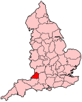
Gloucestershire is a ceremonial county in South West England. It is bordered by Herefordshire to the north-west, Worcestershire to the north, Warwickshire to the north-east, Oxfordshire to the east, Wiltshire to the south, Bristol and Somerset to the south-west, and the Welsh county of Monmouthshire to the west. The city of Gloucester is the largest settlement and the county town.

<span class="mw-page-title-main">South Gloucestershire</span> Local government district in Gloucestershire, England

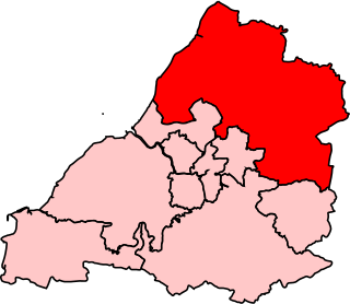
South Gloucestershire is a unitary authority area in the ceremonial county of Gloucestershire, South West England. Towns in the area include Yate, Chipping Sodbury, Kingswood, Thornbury, Filton, Patchway and Bradley Stoke. The southern part of its area falls within the Greater Bristol urban area surrounding the city of Bristol.

<span class="mw-page-title-main">Yate</span> Town in South Gloucestershire, England

Yate is a town and civil parish in South Gloucestershire, England. It lies just to the southwest of the Cotswold Hills and is 12 miles northeast of Bristol and 12 miles from Bath.

<span class="mw-page-title-main">Chipping Sodbury</span> Human settlement in England

Chipping Sodbury is a market town and civil parish in the unitary authority area of South Gloucestershire, in the county of Gloucestershire, England. It is situated 13 miles north-east of Bristol and directly east of Yate. The town was founded in the 12th century by William le Gros. It is the main settlement in the civil parish of Sodbury, which also includes the village of Old Sodbury.

<span class="mw-page-title-main">Northavon</span>

Northavon was a district in the English county of Avon from 1974 to 1996.

<span class="mw-page-title-main">Bristol North West (UK Parliament constituency)</span> Constituency represented in the House of Commons

Bristol North West is a constituency represented in the House of Commons of the UK Parliament since 2017 by Darren Jones of the Labour Party.

<span class="mw-page-title-main">The Cotswolds (UK Parliament constituency)</span> Parliamentary constituency in the United Kingdom, 1997 onwards

The Cotswolds is a constituency in Gloucestershire represented in the House of Commons of the UK Parliament by Sir Geoffrey Clifton-Brown, a Conservative, since its 1997 creation.

<span class="mw-page-title-main">Northavon (UK Parliament constituency)</span>

Northavon was, from 1983 until 2010, a constituency represented in the House of Commons of the Parliament of the United Kingdom. It elected one Member of Parliament (MP) by the first past the post system of election.

<span class="mw-page-title-main">Stroud (UK Parliament constituency)</span> Parliamentary constituency in the United Kingdom, 1955 onwards

Stroud is a constituency represented in the House of Commons of the UK Parliament. It is held by Siobhan Baillie of the Conservative Party. Formerly a safe Conservative seat, Stroud has been a marginal seat since 1997, changing hands four times in seven elections.

Dodington is a village and civil parish in South Gloucestershire, England. The village lies in a small, fertile valley between Codrington and Old Sodbury, and runs together with the even tinier hamlet of Coombes End. It is about 2.5 miles southeast of Chipping Sodbury and four miles from Yate railway station.

<span class="mw-page-title-main">Filton and Bradley Stoke (UK Parliament constituency)</span> Parliamentary constituency in the United Kingdom

Filton and Bradley Stoke is a constituency represented in the House of Commons of the UK Parliament since 2010 by Jack Lopresti, a Conservative.

The city of Bristol, England, is divided into many areas, which often overlap or have non-fixed borders. These include Parliamentary constituencies, council wards and unofficial neighbourhoods. There are no civil parishes in Bristol.

The region of South West England has, since the 2010 general election, 55 parliamentary constituencies which is made up of 15 borough constituencies and 40 county constituencies. At that election the Conservative Party held the largest number of constituencies, with 36. The Liberal Democrats had 15 and Labour had 4. At the 2015 general election the Liberal Democrats lost all of their seats, while the Conservatives gained one seat from Labour, leaving the Conservatives with 51 and Labour with 4. In the 2017 general election, the Conservatives remained, by far, the largest party with 47 seats, though losing three to Labour, who won 7, and one to the Liberal Democrats, who won 1. In the 2019 general election, the Conservatives increased their number of seats to 48 by regaining Stroud from Labour, who held their other six seats, while the Liberal Democrats retained their sole seat in Bath.

Gloucester 1 is an English rugby union league which sits at the ninth level of league rugby union in England for teams based primarily in the county of Gloucestershire but also on occasion teams from Bristol. Promoted clubs move into Gloucester Premier and relegated clubs drop into either Gloucester 2 North or Gloucester 2 South depending on location. Each year clubs in this division also take part in the RFU Junior Vase - a level 9-12 national competition.

<span class="mw-page-title-main">Avon Green Belt</span> Area protected from urban development in South West England

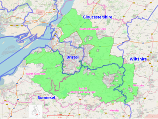
The Avon Green Belt, also known as the Bristol and Bath Green Belt, is a non-statutory green belt environmental and planning policy that regulates urban expansion and development in the countryside surrounding the cities of Bristol and Bath in the South West region of England. It covers areas in Bristol, South Gloucestershire, North Somerset, Bath and North East Somerset, Mendip, and Wiltshire. Essentially, the function of the green belt is to limit urban sprawl and maintain the open character of areas around the Bristol and Bath built up areas, and nearby towns and villages. The policy is implemented by local planning authorities on the basis of guidance from central government.

<span class="mw-page-title-main">Grumbald's Ash Hundred</span>

Grumbald's Ash Hundred was a subdivision of the county of Gloucestershire, England. Hundreds originated in the late Saxon period and lasted as administrative divisions until the 19th century. It has been reported that the court was originally held under an Ash tree situated in Doddington parish, although this location would not be consistent with the previous split of hundred. Its name survives in the Grumbolds Ash with Avening electoral ward of Cotswold district council.

References

  1. "England Parliamentary electorates 2010-2018". Boundary Commission for England. Retrieved 23 March 2019.
  2. 1 2 "Final Recommendations for Parliamentary Constituency Boundaries in the Unitary Authority of South Gloucestershire". Boundary Commission for England. 15 November 2001. Archived from the original on 2 November 2009. Retrieved 24 April 2010.
  3. "The South Gloucestershire (Electoral Changes) Order 2018". legislation.gov.uk. Retrieved 29 March 2020.
  4. Wood, Alex (18 January 2018). "Everything you need to know about the South Gloucestershire boundary changes". Bristol Post. Retrieved 29 March 2020.
  5. "The Parliamentary Constituencies Order 2023". Schedule 1 Part 7 South West region.
  6. "New Seat Details - Thornbury and Yate". www.electoralcalculus.co.uk. Retrieved 21 February 2024.
  7. "South West | Boundary Commission for England". boundarycommissionforengland.independent.gov.uk. Retrieved 20 June 2023.
  8. Unemployment claimants by constituency The Guardian
  9. "Bristol North West 1950-". Parliamentary Debates (Hansard) . Retrieved 2 February 2015.
  10. Leigh Rayment's Historical List of MPs – Constituencies beginning with "B" (part 6)
  11. "Green Party announces candidates for all four South Gloucestershire constituencies". Mark Pack . Retrieved 13 March 2024.
  12. "Liberal Democrat Prospective Parliamentary Candidates". Mark Pack . Retrieved 29 February 2024.
  13. "Thornbury and Yate Constituency". Reform UK . Retrieved 29 February 2024.
  14. "Parliamentary general election - 12 December 2019". South Gloucestershire Council. 5 May 2017. Retrieved 16 November 2019.
  15. 1 2 "Thornbury & Yate parliamentary constituency". BBC News.
  16. "Election Data 2015". Electoral Calculus. Archived from the original on 18 May 2015. Retrieved 17 October 2015.
  17. "Election Data 2010". Electoral Calculus. Archived from the original on 26 July 2013. Retrieved 17 October 2015.
  18. "Election 2010 – Constituency – Thornbury & Yate". BBC News.
  19. Percentage change and swing for 2010 is calculated relative to the PA (Rallings and Thrasher) 2005 notional result, not actual 2005 result "Press Association Elections". Press Association . Retrieved 17 July 2017.

51°34′23″N2°28′37″W / 51.573°N 2.477°W / 51.573; -2.477