Chipping Sodbury

Last updated

Chipping Sodbury
Chipping.sodbury.street.arp.750pix.jpg
The wide main street of Chipping Sodbury. Cars are parked where market stalls would once have been.
Gloucestershire UK location map.svg
Red pog.svg
Chipping Sodbury
Location within Gloucestershire
Population5,500 (2021 Census) [1]
OS grid reference ST726822
Civil parish
  • Sodbury
Unitary authority
Ceremonial county
Region
Country England
Sovereign state United Kingdom
Post town BRISTOL
Postcode district BS37
Dialling code 01454
Police Avon and Somerset
Fire Avon
Ambulance South Western
UK Parliament
List of places
UK
England
Gloucestershire
51°32′17″N2°23′38″W / 51.538°N 2.394°W / 51.538; -2.394

Chipping Sodbury is a market town in the unitary authority area of South Gloucestershire, in the ceremonial county of Gloucestershire, England. Situated 13 miles (21 km) north-east of Bristol, it was founded in the 12th century by William le Gros. It is the principal settlement in the civil parish of Sodbury, which also includes the village of Old Sodbury. Sodbury parish council has elected to be known as Sodbury Town Council. Little Sodbury is a nearby but separate civil parish.

Contents

At the 2011 census the population of Chipping Sodbury was 5,045, but since the 1999s the town has become part of a larger built-up area due to the rapid expansion of nearby Yate, with which it is contiguous to the west. At the census the combined population of Yate and Chipping Sodbury was 26,834.

Governance

An electoral ward in the same name (not Sodbury) exists. This ward starts in the north at Chipping Sodbury Golf Course and stretches south to Dodington. The total population of the ward taken at the 2011 census was 6,834. [2] In 1931 the parish had a population of 973. [3] On 1 April 1946 the parish was abolished to form Sodbury. [4]

Transport

East of the town is the Chipping Sodbury Tunnel, a railway tunnel under the Cotswolds 2 miles 924 yards (4.06 km) long, which was opened by the Great Western Railway in 1902. The tunnel is notorious for flooding in wet weather, often leading to disruption of services on the main railway line to and from South Wales. Chipping Sodbury had a station from 1903 to 1961. [5] Yate station, on the Bristol to Birmingham main line, closed in January 1965 but reopened in May 1989.

The WESTlink on-demand bus serves the town.

Cultural activities

Chipping Sodbury Town Hall Town Hall, Broad Street, Chipping Sodbury, Gloucestershire 2019 (geograph 6315659) (cropped).jpg
Chipping Sodbury Town Hall

Chipping Sodbury hosts a twice yearly Mop Fair, usually the last weekends of March and September. [6] The town holds a Festival Week in early June, including a "Big Lunch" where the main road is closed and residents bring picnics to eat on the street. [7] A Big Lunch is also held in December to combat loneliness amongst elderly people at Christmas. There is a farmers' market twice a month, on the second and fourth Saturdays.

A Victorian Day is held on the first Saturday in December. [8] The event starts with school choirs performing in the street, followed by the arrival of Father Christmas with snow guaranteed (from a blower). The streets are lined with stalls from local charities and organisations and old time amusements, including a Ferris wheel, Helter Skelter and two children's rides. Choirs sing, bands play, the stalls bring a market feel, and a Hog Roast is held.

The town celebrated its 800th anniversary in August 2018 with a weekend of medieval activities including another Big Lunch. A time capsule was buried containing photographs of local businesses and poems written by local schoolchildren. The capsule is to be dug up on the town's 900th anniversary in August 2118.

The town is served by a community radio station, GLOSS FM, which broadcasts 365 days a year on its webcasts and twice a year on 87.7 MHz FM. Chipping Sodbury Town Hall, which was remodelled in 1858, is a significant events venue in the town. [9]

Education

Chipping Sodbury has two government funded primary schools and a secondary school.

Chipping Sodbury School, the secondary school, caters for children aged 11 to 18 and describes itself as a 'Specialist Technology School'. [10] The School shares a sixth form, named Cotswold Edge, with both Brimsham Green School and Yate International Academy. Subjects taken by students are split between the three locations. The School obtained a 'Requires Improvement' status from Ofsted in 2018. [11]

St John's Mead Primary School is named after the parish church, St. John's Chipping Sodbury. The other primary school is Raysfield Infants and Junior schools. Also within the parish boundary is Old Sodbury Primary School.

Dodington Parish Hall, which is situated next to Raysfield Junior and Infant Schools, is also the home of Raysfield Preschool.

Toponymy

The town's name is recorded in Old English (in the dative case) as Soppanbyrig = "Soppa's fort". "Chipping" (from Old English cēping) means that a market was held there. [12]

The main street of Chipping Sodbury seen from an aircraft (2017) Aerial of Chipping Sodbury, South Gloucestershire, England 24May17 arp.jpg
The main street of Chipping Sodbury seen from an aircraft (2017)

Notable people

Edward Jenner, pioneer of vaccination in the 18th century, started his medical training in Sodbury, observing people catching cowpox and then not catching smallpox. [13]

RC "Jack" Russell: former England cricket wicketkeeper and artist owns an art gallery in the town. [14]

Sir James Dyson, inventor of the Dual Cyclone bagless vacuum cleaner, lives at Dodington Park just outside Chipping Sodbury. [15]

J. K. Rowling, author of the Harry Potter fantasy series, was born in 1965 at the Chipping Sodbury Maternity Hospital (later the Chipping Sodbury Memorial Day Centre), on Station Road, Yate. Until the age of four, she lived with her parents in Sundridge Park, Yate. [16] [17] [18]

Related Research Articles

<span class="mw-page-title-main">Gloucestershire</span> County of England

Gloucestershire is a ceremonial county in South West England. It is bordered by Herefordshire to the north-west, Worcestershire to the north, Warwickshire to the north-east, Oxfordshire to the east, Wiltshire to the south, Bristol and Somerset to the south-west, and the Welsh county of Monmouthshire to the west. The city of Gloucester is the largest settlement and the county town.

<span class="mw-page-title-main">South Gloucestershire</span> District in England

South Gloucestershire is a unitary authority area in the ceremonial county of Gloucestershire, South West England. Towns in the area include Yate, Chipping Sodbury, Thornbury, Filton, Patchway and Bradley Stoke. The southern part of its area falls within the Greater Bristol urban area surrounding the city of Bristol.

<span class="mw-page-title-main">Yate</span> Town in South Gloucestershire, England

Yate is a town and civil parish in South Gloucestershire, England. It lies just to the southwest of the Cotswold Hills and is 12 miles northeast of Bristol city centre and 12 miles from the centre of Bath, with regular rail services to Bristol and Gloucester.

<span class="mw-page-title-main">Chipping Campden</span> Town in Gloucestershire, England

Chipping Campden is a market town in the Cotswold district of Gloucestershire, England. It is notable for its terraced High Street, dating from the 14th century to the 17th century.

<span class="mw-page-title-main">Wotton-under-Edge</span> Market town in Gloucestershire, England

Wotton-under-Edge is a market town and civil parish in the Stroud district of Gloucestershire, England. Near the southern fringe of the Cotswolds, the Cotswold Way long-distance footpath passes through the town.

<span class="mw-page-title-main">Wickwar</span> Human settlement in England

Wickwar is a village and civil parish in Gloucestershire, England, located between Yate and Charfield. At the 2001 census, the parish had a population of 1,943.

<span class="mw-page-title-main">Little Sodbury</span> Human settlement in England

Little Sodbury is a village and former civil parish, now in the parish of Horton, in the South Gloucestershire district, in the ceremonial county of Gloucestershire, England. It is located between Chipping Sodbury, to the west, Old Sodbury to the south, Badminton, and the A46 road to the east and Horton and Hawkesbury Upton, to the north. In 2011 the parish had a population of 113. On 1 April 2023 the parish was abolished and merged with Horton.

<span class="mw-page-title-main">Westerleigh</span> Human settlement in England

Westerleigh is a clustered village in the civil parish of Westerleigh and Coalpit Heath in the South Gloucestershire district, in the ceremonial county of Gloucestershire, England, it contains sources of the Frome and has an endpoint of the Frome Valley Walkway. It is 0.8 miles (1.3 km) north of the M4, 1 mile (1.6 km) south of Yate and 10 miles (16 km) north-east of the city of Bristol. In the south it includes a steep hill of its own 5 miles (8.0 km) from the crest of the Cotswold hills which is designated an AONB.

<span class="mw-page-title-main">Northavon (UK Parliament constituency)</span>

Northavon was, from 1983 until 2010, a constituency represented in the House of Commons of the Parliament of the United Kingdom. It elected one Member of Parliament (MP) by the first past the post system of election.

<span class="mw-page-title-main">Acton Turville</span> Human settlement in England

Acton Turville is a parish in the Cotswold Edge ward within South Gloucestershire, England. It lies 17 miles (27 km) east-northeast of Bristol and 93 miles (150 km) due west of London, with the M4 south of the parish. Acton Turville consists of a cluster of households across 1,009 acres, with a total population of 370 people. Acton Turville is also listed as "Achetone" in the Domesday Book.

<span class="mw-page-title-main">Hawkesbury, Gloucestershire</span> Village and civil parish in South Gloucestershire, UK

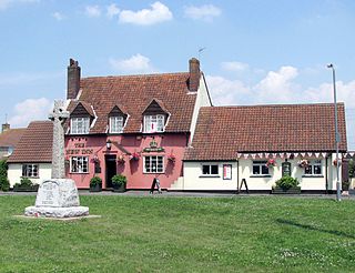
Hawkesbury is a hamlet and civil parish in the area of the South Gloucestershire unitary authority in England. The hamlet, consisting of a few cottages around a triangular green, lies west of Hawkesbury Upton, off the A46 road.

<span class="mw-page-title-main">Old Sodbury</span> Human settlement in England

Old Sodbury is a small village and former civil parish in the valley of the River Frome just below and to the west of the Cotswold escarpment and to the east of Chipping Sodbury and Yate, now in the parish of Sodbury, in the South Gloucestershire district, in the ceremonial county of Gloucestershire, England. It is situated in the Hundred of Grumbald's Ash. The village extends from Chipping Sodbury in the West to the Cotswold Edge in the East and is on the Cotswold Way. The Badminton Road (A432) winds eastwards towards Badminton, Gloucestershire through the village, up to the Cross Hands junction with the A46, which runs along the top of the Cotswold escarpment from Bath to Stroud. In 1931 the parish had a population of 837. On 1 April 1946 the parish was abolished to form Sodbury.

Dodington is a village and civil parish in South Gloucestershire, England. The village lies in a small, fertile valley between Codrington and Old Sodbury, and runs together with the even tinier hamlet of Coombes End. It is about 2.5 miles southeast of Chipping Sodbury and four miles from Yate railway station.

<span class="mw-page-title-main">Thornbury and Yate (UK Parliament constituency)</span>

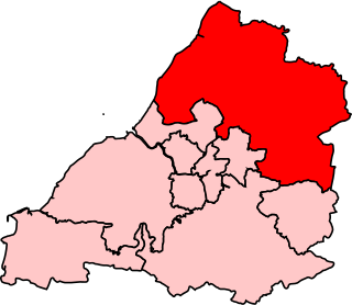
Thornbury and Yate is a constituency represented in the House of Commons of the UK Parliament since the 2015 election by Luke Hall, a member of the Conservative Party. Encompassing an area to the north-east of Bristol, it is one of three constituencies that make up the South Gloucestershire Unitary Authority Area, along with Filton and Bradley Stoke and Kingswood.

<span class="mw-page-title-main">Brimsham Green School</span> Community school in Yate, Gloucestershire, England

Brimsham Green School is a comprehensive secondary school in Yate, South Gloucestershire, England.

Yate Academy is a secondary school located in the town of Yate in South Gloucestershire, on the outskirts of Bristol, England. It was founded in 1953.

<span class="mw-page-title-main">Chipping Sodbury Tunnel</span>

Chipping Sodbury Tunnel is a railway tunnel that is situated on the South Wales Main Line in England. It runs under the Cotswold Hills for 4444 yards, approximately 2+12 miles (4.0 km) west of Badminton railway station and Chipping Sodbury Yard.

Chipping Sodbury School is a coeducational secondary school and sixth form, located in Chipping Sodbury in the Unitary authority of South Gloucestershire, England. It shares ground with the Cotswold Edge sixth-form.

<span class="mw-page-title-main">Grumbald's Ash Hundred</span>

Grumbald's Ash Hundred was a subdivision of the county of Gloucestershire, England. Hundreds originated in the late Saxon period and lasted as administrative divisions until the 19th century. It has been reported that the court was originally held under an Ash tree situated in Doddington parish, although this location would not be consistent with the previous split of hundred. Its name survives in the Grumbolds Ash with Avening electoral ward of Cotswold district council.

References

  1. "SODBURY". City population. Retrieved 25 October 2022.
  2. "Ward population 2011". Archived from the original on 2 April 2015. Retrieved 19 March 2015.
  3. "Population statistics Chipping Sodbury AP/CP through time". A Vision of Britain through Time . Retrieved 8 December 2022.
  4. "Relationships and changes Chipping Sodbury AP/CP through time". A Vision of Britain through Time. Retrieved 8 December 2022.
  5. Butt, R.V.J. (1995). The Directory of Railway Stations. Yeovil: Patrick Stephens Ltd. p. 60. ISBN   1-85260-508-1. R508.
  6. "Mop Fair". Sodbury Town Council. Archived from the original on 26 March 2011. Retrieved 24 August 2020.
  7. "Chipping Sodbury Festival". Chipping Sodbury Festival. Archived from the original on 4 February 2019. Retrieved 24 August 2020.
  8. "Chipping Sodbury Victorian Day". My Sodbury. Archived from the original on 14 May 2017. Retrieved 24 August 2020.
  9. Historic England. "Town Hall (1129244)". National Heritage List for England . Retrieved 21 January 2022.
  10. "Chipping Sodbury School - Home Page". chippingsodburyschool.com. Archived from the original on 15 January 2018. Retrieved 5 February 2018.
  11. "Chipping Sodbury School - Ofsted Inspection Report 2018". Ofsted. Archived from the original on 13 September 2018. Retrieved 5 February 2018.
  12. Ekwall, Eilert (1960). The Concise Oxford Dictionary of English Place Names. Oxford University Press. p. 105. ISBN   978-0-19-869103-7.
  13. Womack, Alexandra (21 May 2013). "Edward Jenner's home recognised in new Chipping Sodbury heritage trail launched by Mark Horton". Gazette. Archived from the original on 24 August 2020. Retrieved 24 August 2020.
  14. http://www.jackrussell.co.uk/ Archived 19 October 2013 at the Wayback Machine Retrieved September 2013
  15. Hellen, Nicholas; Boswell, Josh (28 December 2014). "Dyson bags a bigger estate than the Queen". The Sunday Times. ISSN   0956-1382. Archived from the original on 29 October 2019. Retrieved 29 October 2019.
  16. Connie Ann Kirk, J.K. Rowling: A Biography, Greenwood Publishing Group, 2003, pp.11–12
  17. C. D. Miller, Harry Potter Places: Snitch-Seeking in Southern England and Wales, Book 3, First Edition Design Pub., 2012, pp.110–113
  18. Lynne Hutchinson, Concerns raised about future of former Chipping Sodbury cottage hospital site, Gazette Series, 6 September 2012 Archived 4 April 2014 at the Wayback Machine . Retrieved 6 April 2013