
South Gloucestershire is a unitary authority area in the ceremonial county of Gloucestershire, South West England. Towns in the area include Yate, Chipping Sodbury, Kingswood, Thornbury, Filton, Patchway and Bradley Stoke. The southern part of its area falls within the Greater Bristol urban area surrounding the city of Bristol.

Kingswood is a town and civil parish in the South Gloucestershire district of the ceremonial county of Gloucestershire, England. The town is situated 3 miles (4.8 km) east-northeast of Bristol.
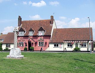
Westerleigh is a clustered village in the civil parish of Westerleigh and Coalpit Heath in the South Gloucestershire district, in the ceremonial county of Gloucestershire, England, it contains sources of the Frome and has an endpoint of the Frome Valley Walkway. It is 0.8 miles (1.3 km) north of the M4, 1 mile (1.6 km) south of Yate and 10 miles (16 km) north-east of the city of Bristol. In the south it includes a steep hill of its own 5 miles (8.0 km) from the crest of the Cotswold hills which is designated an AONB.
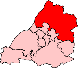
Northavon was, from 1983 until 2010, a constituency represented in the House of Commons of the Parliament of the United Kingdom. It elected one Member of Parliament (MP) by the first past the post system of election.

Iron Acton is a village, civil parish and former manor in South Gloucestershire, England. The village is about 2 miles (3 km) west of Yate and about 9 miles (14 km) northeast of the centre of Bristol. The B4058 road used to pass through the village but now by-passes it just to the north.

Frampton Cotterell is a large village and parish, in South Gloucestershire, South West England, on the River Frome. The village is contiguous with Winterbourne to the south-west and Coalpit Heath to the east. The parish borders Iron Acton to the north and Westerleigh to the south-east, the large town of Yate is 2.1 miles (3.4 km) away. The village is 7.5 miles (12 km) north-east of the city of Bristol.

Pucklechurch is a large village and civil parish in South Gloucestershire, England. It has a current population of about 3000. The village dates back over a thousand years and was once the site of a royal hunting lodge, as it adjoined a large forest.

The Diocese of Bristol is an ecclesiastical jurisdiction or diocese of the Church of England in the Province of Canterbury, England. It is based in the city of Bristol and covers South Gloucestershire and parts of north Wiltshire, as far east as Swindon. The diocese is headed by the Bishop of Bristol and the Episcopal seat is located at the Cathedral Church of the Holy and Undivided Trinity, commonly known as Bristol Cathedral.

Kingswood or Kingswood with Burgh Heath is a residential area on the North Downs in the Borough of Reigate and Banstead in Surrey, England. Part of the London commuter belt, Kingswood is just to the east of the A217 separating it from Tadworth and has a railway station. Burgh Heath in its north is combined with it to form a ward. Reigate is 3.6 miles (5.8 km) south of its centre and London is 15.5 miles (24.9 km) to the north northeast. Kingswood with Burgh Heath had a population of 6,891 in 2011.

St Michael the Archangel Church or simply St Michael's Church is an Anglican parish church located in Winterbourne, South Gloucestershire, on the northern fringe of Bristol. It was built in the 12th century and has been designated by English Heritage as a grade I listed building.
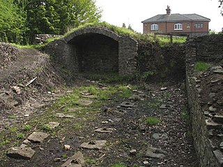
Ram Hill Colliery, was a privately owned colliery in the Coalpit Heath area north-east of Bristol, England. It operated between about 1825 and 1865.

Henfield is a hamlet in the civil parish of Westerleigh and Coalpit Heath, in the South Gloucestershire district, in the ceremonial county of Gloucestershire, England. It is between Coalpit Heath and Westerleigh, adjoining the hamlet of Ram Hill immediately to the north.

Siston Brook rises in two separate streams which issue from a ridge just north of the village of Siston, South Gloucestershire, England. The brook is approximately 6 miles (9.7 km) long and is a tributary of the Bristol Avon. Much of its course is through the eastern suburbs of Bristol, although it remains outside the city boundaries. Tributaries include the Warmley Brook and an unnamed tributary from Bridgeyate.

The Bristol Coalfield is a geologically complex coalfield in the west of England. Comprising the coal-bearing rocks arranged around the Coalpit Heath Syncline and Kingsdown Anticline, it extends beneath the eastern parts of the city of Bristol and northwards through southern Gloucestershire. The coalfield is sometimes referred to together with the Somerset Coalfield, which lies to its south, as the Bristol and Somerset Coalfield. There are also two outlying coal-mining areas, the Severn Coalfield and the Nailsea Basin which are described below.

Ram Hill is a hamlet in the civil parish of Westerleigh and Coalpit Heath, in the South Gloucestershire district, in the ceremonial county of Gloucestershire, England. It is located between Coalpit Heath and Westerleigh and adjoins the hamlet of Henfield immediately to the south. In the Mudge Map 1815, Ram Hill was known as Nutridge Hill, and was linked to Westerleigh by Broad Lane and to Mays Hill by Frog Lane.
Gloucester 1 is an English rugby union league which sits at the ninth level of league rugby union in England for teams based primarily in the county of Gloucestershire but also on occasion teams from Bristol. Promoted clubs move into Gloucester Premier and relegated clubs drop into either Gloucester 2 North or Gloucester 2 South depending on location. Each year clubs in this division also take part in the RFU Junior Vase - a level 9-12 national competition.
The Bristol and Gloucestershire Railway was an early mineral railway, opened in two stages in 1832 and 1834, which connected collieries near Coalpit Heath with Bristol, at the river Avon. Horse traction was used. It was later taken over by the Bristol and Gloucester Railway, and much of the route became part of the main line between Birmingham and Bristol, though that was later by-passed and closed. Part of it now forms the Bristol and Bath Railway Path.

The Avon and Gloucestershire Railway also known as The Dramway was an early mineral railway, built to bring coal from pits in the Coalpit Heath area, north-east of Bristol, to the River Avon opposite Keynsham. It was dependent on another line for access to the majority of the pits, and after early success, bad relations and falling traffic potential dogged most of its existence.


