
Day County is a county in the U.S. state of South Dakota. As of the 2010 census, the population was 5,710. Its county seat is Webster. The county is named for Merritt H. Day, pioneer and 1879 Dakota Territory legislator.
Corson County is a county in the U.S. state of South Dakota. As of the 2010 census, the population was 4,050. Its county seat is McIntosh. The county was named for Dighton Corson, a native of Maine, who came to the Black Hills in 1876, and in 1877 began practicing law at Deadwood.
Codington County is a county in the U.S. state of South Dakota. As of the 2010 United States Census, the population was 27,227. Its county seat is Watertown. The county was created in 1877 and organized in 1878. It is named for Rev. George S. S. Codington, Dakota Territory legislator.

Clark County is a county in the U.S. state of South Dakota. As of the 2010 census, the population was 3,691. Its county seat is Clark. The county was created in 1873 and organized in 1881. It was named for Newton Clark, a Dakota Territory legislator in 1873.

Stark County is a county in the U.S. state of North Dakota. As of the 2010 United States Census, the population was 24,199. Its county seat is Dickinson.

Morton County is a county in the U.S. state of North Dakota. As of the 2010 United States Census, the population was 27,471, making it the seventh-most populous county in North Dakota. Its county seat is Mandan. Morton County is included in the Bismarck, ND, Metropolitan Statistical Area.
Grant County is a county in the U.S. state of North Dakota. As of the 2010 United States Census, the population was 2,394. Its county seat is Carson.
Burleigh County is a county in the U.S. state of North Dakota. As of the 2010 United States Census, the population was 81,308, making it the second-most populous county in North Dakota. Its county seat is Bismarck, the state capital. The county was named for Dakota Territory political figure Walter A. Burleigh.

Redwood County is a county in the U.S. state of Minnesota. As of the 2010 United States Census the population was 16,059. Its county seat is Redwood Falls, along the Redwood River near its confluence with the Minnesota River.

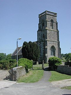
Thornbury is a market town and civil parish in the South Gloucestershire unitary authority area of the ceremonial county of Gloucestershire, England, about 12 miles north of Bristol. It had a population of 12,063 at the 2011 Census, estimated at 12,459 in 2019. Thornbury is a Britain in Bloom award-winning town, with its own competition: Thornbury in Bloom. The earliest documentary evidence of a village at "Thornbyrig" dates from the end of the 9th century. Domesday Book noted a manor of "Turneberie" belonging to William the Conqueror's consort, Matilda of Flanders, with 104 residents.

South Gloucestershire is a unitary authority area in South West England. It comprises multiple suburban areas to the north and east of Bristol as well as a large rural hinterland. South Gloucestershire was created in 1996 from the northern section of the county of Avon, which was abolished at that time.

Thornbury Township is a township in Chester County, Pennsylvania, United States. The population was 3,017 at the 2010 census. It is adjacent to, and was once joined with, Thornbury Township, Delaware County, Pennsylvania.
Thornbury Township is a township in Delaware County, Pennsylvania, United States. The population was 8,028 at the 2010 census, up from 7,093 at the 2000 census. It is adjacent to, and was once joined with, Thornbury Township, Chester County, Pennsylvania. It contains part of the census designated place of Cheyney University.
Rockhampton is a village and civil parish in the English county of Gloucestershire, situated in the unitary district of South Gloucestershire. It is located 2.8 miles (4.5 km) northeast of Thornbury, 18.6 miles (30 km) north of Bristol and is approximately 4 miles (6.4 km) east of the River Severn. It had a population of 166 people according to the 2011 census.
Tytherington is a village in South Gloucestershire, England, situated 2 miles (3.2 km) south east of Thornbury. The parish population taken at the 2011 census was 666.

Hill is a village and civil parish in South Gloucestershire, England, midway between the towns of Thornbury in South Gloucestershire and Berkeley in Gloucestershire. The parish stretches from the banks of the River Severn to an outcrop of the Cotswold escarpment. At the 2001 census, it had a population of 114. Hill is approximately 5 miles from the M5 motorway which links to Gloucester, Cheltenham and Bristol.
Alkington is a civil parish in the district of Stroud, Gloucestershire. It had a population of 638 in the 2001 census, increasing to 688 at the 2011 census. There is no Alkington village, the parish consists of various hamlets, including Woodford, Newport and Lower Wick.

Thornbury and Yate is a constituency represented in the House of Commons of the UK Parliament since the 2015 election by Luke Hall, a Conservative. Encompassing an area to the north-east of Bristol, it is one of three constituencies that make up the South Gloucestershire Unitary Authority Area, along with Filton and Bradley Stoke and Kingswood.

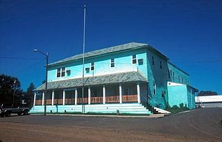
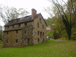
Mortonville is an unincorporated area and historic hamlet in Chester County, Pennsylvania on the eastern bank of the West Branch Brandywine Creek. It consists of about a half-dozen structures, two of which are on the National Register of Historic Places: the Mortonville Hotel, and the 12.5-foot-long (3.8 m) "Bridge in East Fallowfield Township" which crosses a mill race a few feet east of a larger bridge. The larger bridge, known as the Mortonville Bridge, was also listed on the NRHP until 2010 when it was delisted following a renovation. The two bridges are in East Fallowfield Township, while most other structures are in Newlin Township.

Morton Vale is a rural locality in the Lockyer Valley Region, Queensland, Australia. In the 2016 census Morton Vale had a population of 143 people.
