Oldland Common

Last updated

Oldland Common
Gloucestershire UK location map.svg
Red pog.svg
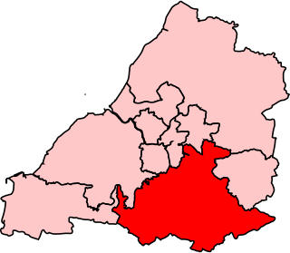
Oldland Common
Location within Gloucestershire
Population7,000 
OS grid reference ST674717
Civil parish
Unitary authority
Ceremonial county
Region
Country England
Sovereign state United Kingdom
Post town BRISTOL
Postcode district BS30
Dialling code 0117
Police Avon and Somerset
Fire Avon
Ambulance South Western
UK Parliament
List of places
UK
England
Gloucestershire
51°26′37″N2°28′11″W / 51.4437°N 2.4697°W / 51.4437; -2.4697

Oldland Common is a village in the far south region of South Gloucestershire, England, on the outskirts of Bristol. It is in the civil parish of Bitton, approximately 8 miles between the centres of cities Bristol and Bath.

Contents

A view of a rank of cottages, High Street, Oldland Common Cottages, Oldland Common High Street - geograph.org.uk - 1705190.jpg
A view of a rank of cottages, High Street, Oldland Common

Oldland Common is the birthplace of the famous astronomer Sir Bernard Lovell, and is home to the Sir Bernard Lovell secondary school, a designated language college opened by Lovell himself in 1972, once attended by England cricketer Marcus Trescothick and Millwall FC manager, and former Bristol Rovers FC player, Ian Holloway. Other schools in the village are St. Anne's Church of England Primary School (built in 1837 & initially called Oldland National School) and Redfield Edge Primary School.

The village lies on the Avon Valley Railway, a three-mile long heritage railway, where it is served by Oldland Common railway station. It is part of the civil parish of Bitton which has a population of approx. 9,000 (according to the 2011 Census). The village is adjacent to the villages of Bitton and Bridgeyate.

Oldland Common was first mentioned in the Domesday Book of 1086. As was common in the surrounding area, the village was involved in the coal mining industry and had its own pit on Cowhorn Hill during the 1800s. The largest employment in the late C18 and early C19 was felt hat-making - half the working population at the time of the 1841 census.

The largest place of worship in the village is St Anne's Church of England church. Its grounds contain a separate social area, the Orchard Rooms. Other local churches include the Oldland Methodist Church (shown in photograph above) and the small United Reformed Church.

The village is home to the 54th Kingswood (St Anne's) Scout Group.

On 30 October 2012, mobile phone operator EE launched their 4G signal for superfast internet in Bristol, meaning the village of Oldland Common is now connected to 4G. The 4G signal mast is situated at Redfield Hill in the village. 4G from Three, Vodafone and O2 is also now available in Oldland Common.

Transport

Oldland Common is served by bus company First West of England, which operates the following services through the village;

The nearest rail station is Keynsham railway station, which is 2.5 miles from the village. Direct services are available to Bath Spa railway station, allowing connections to the South and London, and Bristol Temple Meads railway station, allowing connections to the South West, London, the South Coast, Wales, the Midlands, Northern England, and Scotland.

Governance

An electoral ward in the name ‘Bitton and Oldland common’ exists. This stretches north from Oldland Common to Bitton and had a population of 7685 at the time of the 2011 census. [1]

Sport and leisure

Oldland is home to the non-League football clubs Oldland Abbotonians F.C. in the Western Football League and Crown & Horseshoe F.C. in the Bath and District League.

Food, Public Houses & Shopping

The village has two public houses: The Crown and Horseshoe, and The Dolphin. The village previously had three, the third being The Cherry Tree, which is now being converted into flats. Oldland Common also has a Village Club.

Shops in Oldland Common include a newsagent, a post office and several takeaways.

See also

Related Research Articles

<span class="mw-page-title-main">South Gloucestershire</span> Local government district in Gloucestershire, England

South Gloucestershire is a unitary authority area in the ceremonial county of Gloucestershire, South West England. Towns in the area include Yate, Chipping Sodbury, Kingswood, Thornbury, Filton, Patchway and Bradley Stoke. The southern part of its area falls within the Greater Bristol urban area surrounding the city of Bristol.

<span class="mw-page-title-main">Kingswood, South Gloucestershire</span> Town in Gloucestershire, England

Kingswood is a town and civil parish in the South Gloucestershire district of the ceremonial county of Gloucestershire, England. The town is situated 3 miles (4.8 km) east-northeast of Bristol.

<span class="mw-page-title-main">Mangotsfield</span> Human settlement in England

Mangotsfield is a village and former civil parish in the unitary authority area of South Gloucestershire, in the ceremonial county of Gloucestershire, England, to the north-east of Bristol.

<span class="mw-page-title-main">Avon Valley Railway</span> Heritage railway in England

The Avon Valley Railway (AVR) is a standard gauge heritage railway in South Gloucestershire, England, operated by a local group, the Avon Valley Railway Company Ltd. The 3-mile (5 km) heritage line runs from Oldland Common to Avon Riverside. It follows the Avon Valley southeast from Oldland Common to Bitton and then it runs alongside the River Avon from Bitton towards Saltford.

<span class="mw-page-title-main">Staple Hill, Gloucestershire</span> Human settlement in England

Staple Hill is a suburb of Bristol, England, lying outside the city boundary in South Gloucestershire, in the ceremonial county of Gloucestershire. It is directly east of Fishponds, south of Downend, west of Mangotsfield and north of Soundwell.

<span class="mw-page-title-main">Kingswood (UK Parliament constituency)</span> Parliamentary constituency in the United Kingdom, 1974 onwards

Kingswood is a constituency in South Gloucestershire. It is currently represented in the House of Commons of the UK Parliament by Damien Egan of the Labour Party since 2024.

<span class="mw-page-title-main">Wansdyke (UK Parliament constituency)</span>

Wansdyke was a county constituency represented in the House of Commons of the Parliament of the United Kingdom. It elected one Member of Parliament (MP) by the first past the post system of election.

<span class="mw-page-title-main">North East Somerset (UK Parliament constituency)</span> Parliamentary constituency in the United Kingdom

North East Somerset is a constituency represented in the House of Commons of the UK Parliament, since it was created for the 2010 general election, by Jacob Rees-Mogg of the Conservative Party.

<span class="mw-page-title-main">Bitton</span> Village in South Gloucestershire, England

Bitton is a village and civil parish of South Gloucestershire in England, to the east of the Greater Bristol area on the River Boyd.

<span class="mw-page-title-main">Warmley</span> Village in United Kingdom

Warmley is a village in South Gloucestershire, England.

<span class="mw-page-title-main">Diocese of Bristol</span> Diocese of the Church of England

The Diocese of Bristol is an ecclesiastical jurisdiction or diocese of the Church of England in the Province of Canterbury, England. It is based in the city of Bristol and covers South Gloucestershire and parts of north Wiltshire, as far east as Swindon. The diocese is headed by the Bishop of Bristol and the Episcopal seat is located at the Cathedral Church of the Holy and Undivided Trinity, commonly known as Bristol Cathedral.

North Common is a village just outside Warmley, Bristol, in South Gloucestershire, England. Historically this was a rural hamlet surrounded by farmland. The residents are fortunate enough that to the east of the village is attractive rolling countryside, with views of Lansdown, and the surrounding hills. The village is on the eastern outskirts of Bristol and approximately halfway between Bristol city centre and the neighbouring city of Bath.

The city of Bristol, England, is divided into many areas, which often overlap or have non-fixed borders. These include Parliamentary constituencies, council wards and unofficial neighbourhoods. There are no civil parishes in Bristol.

<span class="mw-page-title-main">Lawrence Hill, Bristol</span> Human settlement in England

Lawrence Hill is an electoral ward of Bristol, United Kingdom and includes the districts of Barton Hill, St Philips Marsh and Redcliffe, Temple Meads and parts of Easton and the Broadmead shopping area. Lawrence Hill takes its name from a leper hospital dedicated to St Lawrence, which was founded by King John.

<span class="mw-page-title-main">Warmley railway station</span> Former railway station in England

Warmley was a small railway station just south of Mangotsfield on the Midland Railway Mangotsfield and Bath Branch Line. The station was sited just north of a level crossing on the A420 road through the village. It had wooden buildings: the shelter on the down platform survives and is used on occasion as a refreshment stop on the Bristol & Bath Railway Path, which follows the route of the railway.

<span class="mw-page-title-main">Oldland</span> Village in South Gloucestershire, England

Oldland is a village and civil parish in South Gloucestershire, England. The parish includes the villages of Cadbury Heath and Longwell Green, and part of Willsbridge. It does not include Oldland Common, which is in the parish of Bitton.

<span class="mw-page-title-main">MetroBus (Bristol)</span> Bus rapid transit system in Bristol, UK

MetroBus is a bus rapid transit system in Bristol, England, created as a joint project between Bristol, North Somerset and South Gloucestershire councils. The first route, service m3, began operations on 29 May 2018, followed by m2 on 3 September 2018, m1 on 6 January 2019 and m4 on 22 January 2023.

References

  1. "Ward population 2011" . Retrieved 20 March 2015.