
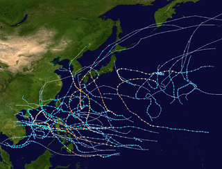
The 2005 Pacific typhoon season was the least active typhoon season since 2000, producing 23 named storms, of which 13 became typhoons. It was an event in the annual cycle of tropical cyclone formation, in which tropical cyclones form in the western Pacific Ocean. The season ran throughout 2005, though most tropical cyclones typically develop between May and October. The season's first named storm, Kulap, developed on January 13, while the season's last named storm, Bolaven, dissipated on November 20. The season's first typhoon, Haitang, reached typhoon status on July 13, and became the first super typhoon of the year three days later.

The 2006 Pacific typhoon season was a near-average season which produced a total of 23 named storms, 15 typhoons, and six super typhoons. The season ran throughout 2006, though most tropical cyclones typically develop between May and October. The season's first named storm, Chanchu, developed on May 9, while the season's last named storm, Trami, dissipated on December 20.

The 2001 Pacific typhoon season was the fourth and final consecutive year with below-average activity, mainly due to the presence of a strong La Niña that had persisted from 1998 to 2001. However, it was more active than the previous seasons, producing twenty-five named storms, sixteen typhoons and three super typhoons, with a near normal Accumulated Cyclone Energy (ACE) of 307.3 units. It ran year-round in 2001, with most tropical cyclones in the northwestern Pacific Ocean tending between May and November.

The 1998 Pacific typhoon season was the least active Pacific typhoon season on record, until it was surpassed 12 years later. It would produce 16 tropical storms, 8 strengthening into typhoons. The scope of this article is limited to the Pacific Ocean, north of the equator and west of the international date line. Storms that form east of the date line and north of the equator are called hurricanes; see 1998 Pacific hurricane season. Tropical Storms formed in the entire west Pacific basin were assigned a name by the Joint Typhoon Warning Center. Tropical depressions in this basin have the "W" suffix added to their number. Tropical depressions that enter or form in the Philippine area of responsibility are assigned a name by the Philippine Atmospheric, Geophysical and Astronomical Services Administration or PAGASA. This can often result in the same storm having two names.

The 1959 Pacific typhoon season was regarded as one of the most devastating years for Pacific typhoons on record, with China, Japan and South Korea sustaining catastrophic losses. It was an event in the annual cycle of tropical cyclone formation. The season had no official bounds, but tropical cyclones in the Western Pacific Ocean normally develop between May and October.
The 1970 Pacific typhoon season has no official bounds; it ran year-round in 1970, but most tropical cyclones tend to form in the northwestern Pacific Ocean between June and December. These dates conventionally delimit the period of each year when most tropical cyclones form in the northwestern Pacific Ocean.

The 1962 Pacific typhoon season had no official bounds; there was activity in every month but January, March, and June, but most tropical cyclones form in the northwestern Pacific Ocean between May and November and this conventionally delimits the season.

This timeline documents all the storm formations, strengthening, weakening, landfalls, extratropical transitions, as well as dissipation during the 2008 Pacific typhoon season. The 2008 Pacific typhoon season officially started on January 1, 2008 and ended on January 1, 2009. The first tropical cyclone of the season formed on January 13. The timeline also includes information which was not operationally released, meaning that information from post-storm reviews by the various warning agencies, such as information on a storm that was not operationally warned on, has been included.
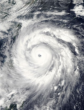
Typhoon Jangmi, known in the Philippines as Super Typhoon Ofel, was the most intense tropical cyclone in the Northwest Pacific Ocean during the 2000s, tied with Nida in 2009, and the most intense tropical cyclone worldwide in 2008. Jangmi, which means rose in Korean, formed in a low pressure area south of Guam on September 22. After undergoing serious consolidating with convective banding, the low pressure area was upgraded to a Joint Typhoon Warning Center late the same data. Undergoing the same process, the storm developed into a tropical storm on September 24. Undergoing rapid deepening on September 26–27, the storm, now a Super Typhoon entered the Philippine Area of Responsibility, and was named Ofel. The next day, Jangmi made impact in Taiwan, thousands were evacuated, rainfall, up to 994mm were recorded, and thousands of acres of farmland were destroyed. Jangmi was significantly weakened as it interacted with Taiwan, as being downgraded to tropical storm status after leaving Taiwan on September 29. After undergoing an extratropical transition, Jangmi became a remnant low on October 1. After slowly moving eastward, until finally dissipating near Iwo Jima on October 5.

The 2018 Pacific typhoon season was at the time, the costliest Pacific typhoon season on record, until the record was beaten by the following year and later 2023. The season was well above-average, producing twenty-nine storms, thirteen typhoons, seven super typhoons and six Category 5 tropical cyclones. The season ran throughout 2018, though most tropical cyclones typically develop between May and October. The season's first named storm, Bolaven, developed on January 3, while the season's last named storm, Man-yi, dissipated on November 28. The season's first typhoon, Jelawat, reached typhoon status on March 29, and became the first super typhoon of the year on the next day.

Typhoon Billie was the first typhoon officially monitored by the Joint Typhoon Warning Center. The storm brought floods to several East Asian countries in July 1959. Billie developed from a tropical disturbance west of Kiribati on July 12. Situated within favorable conditions, the system quickly reached tropical storm intensity before strengthening further to typhoon status a day after formation. Intensification continued until Billie reached its peak intensity on July 14 east of Taiwan with maximum sustained winds of 165 km/h (103 mph) and a minimum barometric pressure of 970 mbar. Slight weakening occurred before the typhoon made landfall on Zhejiang in China on July 16. After tracking inland, Billie curved northward and moved over the Yellow Sea before making a final landfall on North Korea on July 17; the storm transitioned into an extratropical cyclone shortly afterwards before dissipating over the Sea of Japan a day later.

Most of the tropical cyclones of the 2013 Pacific typhoon season formed between May and November of that year. The scope of this article is the Pacific Ocean north of the equator, between 100°E and the International Date Line. Tropical storms which form in the Western Pacific basin are assigned a name by the Japan Meteorological Agency (JMA). Tropical depressions forming in this basin are given a number with a "W" suffix by the United States' Joint Typhoon Warning Center (JTWC). The Philippine Atmospheric, Geophysical and Astronomical Services Administration (PAGASA) assigns names to tropical cyclones that enter or form in the Philippine area of responsibility, but these names are not in common use outside the Philippines.

This timeline documents all of the events of the 2014 Pacific typhoon season. Most of the tropical cyclones forming between May and November. The scope of this article is limited to the Pacific Ocean, north of the equator between 100°E and the International Date Line. Tropical storms that form in the entire Western Pacific basin are assigned a name by the Japan Meteorological Agency. Tropical depressions that form in this basin are given a number with a "W" suffix by the United States' Joint Typhoon Warning Center. In addition, the Philippine Atmospheric, Geophysical and Astronomical Services Administration (PAGASA) assigns names to tropical cyclones that enter or form in the Philippine area of responsibility. These names, however, are not in common use outside of the Philippines.

Typhoon Amy was a super typhoon formed in August and September 1962. Amy made landfall in Taiwan as a category 4 equivalent super typhoon, then in China as a typhoon, moved out into the South China Sea, and finally made landfall in South Korea as a tropical storm.

Typhoon Abe, known as Typhoon Iliang in the Philippines, was the fourteenth named storm of 1990 Pacific typhoon season. Forming on August 23 from a tropical disturbance, the depression which would eventually develop into Typhoon Abe initially tracked in a steady west-northwestward direction. As a result of an intense monsoon surge, Abe's trajectory briefly changed to an eastward then northward path before returning to its original track. Abe only intensified by a small amount between 00:00 UTC August 24 and 06:00 UTC August 27 due to the disruptive effects of the surge, and on August 30, Abe peaked in intensity as a Category 2-equivalent typhoon on the Saffir–Simpson hurricane wind scale. After peaking in intensity, Abe crossed the Ryukyu Islands and the East China Sea, making landfall in China where it affected the provinces of Zhejiang and Jiangsu before entering the Yellow Sea, crossing South Korea, and finally transitioning into an extratropical cyclone.

Typhoon Mary, also nicknamed "Bloody Mary" by the Joint Typhoon Warning Center (JTWC), was an extremely damaging storm that was part of the 1960 Pacific typhoon season. It began as a circulation in a trough in the South China Sea. A tropical depression formed on June 2, as it was traveling clockwise. It became a tropical storm on the next day, and received the name Mary. It slowly moved across the sea, strengthening to a typhoon. Mary made landfall in Hong Kong on June 8, and moved through Guangdong and Fujian. It reemerged back to the Pacific Ocean, and restrengthened into a typhoon temporarily. It then traveled east, weakening and becoming extratropical on June 12.

This timeline documents all of the events of the 2016 Pacific typhoon season. Most of the tropical cyclones forming between May and November. The scope of this article is limited to the Pacific Ocean, north of the equator between 100°E and the International Date Line. Tropical storms that form in the entire Western Pacific basin are assigned a name by the Japan Meteorological Agency. Tropical depressions that form in this basin are given a number with a "W" suffix by the United States' Joint Typhoon Warning Center. In addition, the Philippine Atmospheric, Geophysical and Astronomical Services Administration (PAGASA) assigns names to tropical cyclones that enter or form in the Philippine area of responsibility. These names, however, are not in common use outside of the Philippines.

Typhoon Charlotte was a damaging typhoon that struck Okinawa during the 1959 Pacific typhoon season. An area of low pressure developed in early October, and it became a tropical depression on October 9. The depression strengthened to a tropical storm one day later, and it received the name Charlotte from the Joint Typhoon Warning Center (JTWC). The system strengthened quickly and became a typhoon eighteen hours later. Charlotte continued to rapidly strengthen to its peak of 260 km/h (160 mph) on October 13. The typhoon began to weaken afterwards, and it traveled south of Okinawa on October 16. The typhoon weakened to a tropical storm on October 19 as it began its extratropical transition. The storm became extratropical later that day, and the Japan Meteorological Agency (JMA) ceased tracking the system on October 20.

Typhoon Abby, known as Typhoon Norming in the Philippines, was the second typhoon to affect Taiwan in a month during September 1986. A tropical depression developed on September 13 and the next day attained tropical storm status, upon which it was named Abby. Continuing to intensify, Abby moved west-northwest and became a typhoon on September 16. Two days later, the typhoon attained maximum intensity. On September 19, the typhoon made landfall in Taiwan as it turned towards the northwest. Rapid weakening occurred due to land interaction, and on September 20, Typhoon Abby transitioned into an extratropical cyclone. Its extratropical remnants were last noted on September 24 as they raced off to the northeast.

Typhoon Hagupit, known in the Philippines as Severe Tropical Storm Dindo, was a Category 1 typhoon that heavily impacted Eastern China and South Korea in August 2020. It was the fourth named storm and the second typhoon of the annual typhoon season. The JMA began monitoring a tropical depression that developed in the Philippine Sea on July 30, with PAGASA assigning the name “Dindo” to the storm, later that day it strengthened into a tropical storm, according to the JMA. PAGASA issued its final advisory on Dindo early on August 3, as it moved out of their area of responsibility. Hagupit intensified into a typhoon on August 3, before making landfall in Wenzhou, China at 19:30 UTC that day at peak intensity. Hagupit subsequently weakened over China, before degenerating into an extratropical low on August 5. Hagupit's remnants persisted for another several days, as the storm moved eastward, before dissipating south of Alaska on August 14.


