Megathrust earthquakes occur at convergent plate boundaries, where one tectonic plate is forced underneath another. The earthquakes are caused by slip along the thrust fault that forms the contact between the two plates. These interplate earthquakes are the planet's most powerful, with moment magnitudes (Mw) that can exceed 9.0. Since 1900, all earthquakes of magnitude 9.0 or greater have been megathrust earthquakes.

The Okhotsk Plate is a minor tectonic plate covering the Kamchatka Peninsula, Magadan Oblast, and Sakhalin Island of Russia; Hokkaido, Kantō and Tōhoku regions of Japan; the Sea of Okhotsk, as well as the disputed Kuril Islands. It was formerly considered a part of the North American Plate, but recent studies indicate that it is an independent plate, bounded on the north by the North American Plate. The boundary is a left-lateral moving transform fault, the Ulakhan Fault originating from a triple junction in the Chersky Range. On the east, the plate is bounded by the Pacific Plate at the Kuril–Kamchatka Trench and the Japan Trench, on the south by the Philippine Sea Plate at the Nankai Trough, on the west by the Eurasian Plate, and on the southwest by the Amurian Plate.

Many major earthquakes have occurred in the region of the Kamchatka Peninsula in far eastern Russia. Events in 1737, 1923 and 1952, were megathrust earthquakes and caused tsunamis. There are many more earthquakes and tsunamis originating from the region.
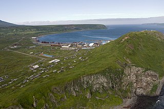
The 1952 Severo-Kurilsk earthquake struck off the coast of the Kamchatka Peninsula. The 9.0 Mw earthquake triggered a major tsunami that hit Severo-Kurilsk, Kuril Islands, Sakhalin Oblast, Russian SFSR, USSR, on 5 November 1952 at 04:58 local time. This led to the destruction of many settlements in Sakhalin Oblast and Kamchatka Oblast, while the main impact struck the town of Severo-Kurilsk. It was the most powerful earthquake ever recorded in Russia, and the fifth most powerful earthquake ever recorded in the world since modern seismography began in 1900.
The 1906 Ecuador–Colombia earthquake occurred at 10:36:10 (UTC+5) on Wednesday January 31, 1906 off the coast of Ecuador, near Esmeraldas. The earthquake had a moment magnitude of 8.8 and triggered a destructive tsunami that caused at least 500 casualties on the coast of Colombia.
The 1997 Kamchatka earthquake, or 1997 Kronotsky earthquake, occurred on December 5 at 11:26 UTC near the east coast of the Kamchatka Peninsula. It was an 7.7 (7.6–7.8) earthquake and was felt with intensity MM V in Petropavlovsk-Kamchatskiy. A 60 cm (23.6 in) tsunami was recorded in Kahului, 47 cm in Hilo, and 15 cm in Unalaska. The local tsunami generated by this earthquake affected a mostly unpopulated region. A post-tsunami survey found runup on the Kronotsky Peninsula was no more than a few meters. However, a later geological survey north of the peninsula, as well as an interview with a park ranger, indicate that runup was up to 8 meters (26 ft) along the coast near the Little and Big Chazhma rivers and north to the Storozh River.

The 1944 Tōnankai earthquake occurred at 13:35 local time on 7 December. It had an estimated magnitude of 8.1 on the moment magnitude scale and a maximum felt intensity of greater than 5 Shindo. It triggered a large tsunami that caused serious damage along the coast of Wakayama Prefecture and the Tōkai region. Together, the earthquake and tsunami caused 3,358 casualties.
The 1959 Kamchatka earthquake occurred on May 4 at with a moment magnitude of 8.0–8.3, and a surface wave magnitude of 8.25. The epicenter was near the Kamchatka Peninsula, Russian SFSR, USSR. Building damage was reported in Petropavlovsk-Kamchatsky. The maximum intensity was VIII (Damaging) on the Medvedev–Sponheuer–Karnik scale. The intensity in Petropavlovsk-Kamchatsky was about VIII MSK.
The November 1960 Peru earthquake occurred offshore northern Peru on November 20 at . The magnitude of the earthquake was Ms 6.75 by using the conventional surface-wave magnitude measurement within a shorter duration of ~20 s. However, there is a large discrepancy between the magnitudes in Ms and Mw in this earthquake. The discrepancy was caused from the earthquake's long source duration of about 130 s, and by calculating the seismic moment, the magnitude would be Mw 7.6 or Mw 7.8, according to different sources. This earthquake belongs to a category of earthquakes with slow rupture velocities and potential of producing tsunamis larger than those expected from the moment magnitudes.
The February 1923 Kamchatka earthquake occurred on 3 February 1923. The epicenter was on the southeastern coast of the Kamchatka Peninsula. The earthquake triggered a tsunami with wave heights up to eight metres, causing damage as far away as Hawaii. The maximum perceived Mercalli intensity was XI (Extreme). The tsunami caused two deaths in Kamchatka and one in Hawaii.
The Nemuro-Oki earthquake in scientific literature, occurred on June 17 at 12:55 local time. It struck with an epicenter just off the Nemuro Peninsula in northern Hokkaidō, Japan. It measured 7.8–7.9 on the moment magnitude scale (Mw ), 8.1 on the tsunami magnitude scale (Mt ) and 7.4 on the Japan Meteorological Agency magnitude scale (MJMA ).
On April 13, 1923 at 15:31 UTC, an earthquake occurred off the northern coast of the Kamchatka Peninsula in the USSR, present-day Russia. The earthquake had a surface-wave magnitude (Ms ) of 6.8–7.3 and an estimated moment magnitude (Mw ) of 7.0–8.2. This event came just two months after a slightly larger earthquake with an epicenter struck south of the April event. Both earthquakes were tsunamigenic although the latter generated wave heights far exceeding that of the one in February. After two foreshocks of "moderate force", the main event caused considerable damage. Most of the 36 casualties were the result of the tsunami inundation rather than the earthquake.
The 1737 Kamchatka earthquake occurred on October 17 or 16 near the southern tip of present-day Russia's Kamchatka Peninsula. The shock was felt at approximately 03:00 local time or 16:00 UTC by residents on the peninsula and Kuril Islands. The earthquake struck at a shallow depth of roughly 40 km beneath the peninsula. The earthquake had an estimated magnitude of 9.0–9.3 on the moment magnitude scale.

An earthquake occurred off the coast of the Alaska Peninsula on July 28, 2021, at 10:15 p.m. local time. The large megathrust earthquake had a moment magnitude of 8.2 according to the United States Geological Survey (USGS). A tsunami warning was issued by the National Oceanic and Atmospheric Administration (NOAA) but later cancelled. The mainshock was followed by a number of aftershocks, including three that were of magnitude 5.9, 6.1 and 6.9 respectively.
The 1586 Lima–Callao earthquake occurred on July 9 along the coast of Peru, near the capital Lima. A section of the Peruvian coast, stretching from Caravelí to Trujillo, north to south, was severely damaged by the earthquake. Major destruction occurred in the capital city Lima as well. The estimated moment magnitude (Mw ) 8.1 earthquake triggered a locally damaging tsunami up to 5 m (16 ft). This was the first major earthquake to strike the city of Lima since its establishment in 1535.
The 1979 Petatlán earthquake, also known as the IBERO earthquake occurred on March 14 at 05:07 local time in the Mexican state of Guerrero. The earthquake had a surface wave magnitude of Ms 7.6 or moment magnitude of Mw 7.4 and maximum Modified Mercalli intensity of VIII (Severe). The epicenter, onshore, was located 12 km south southeast of Vallecitos de Zaragoza.
During April 1819, the area around Copiapó in northern Chile was struck by a sequence of earthquakes over a period of several days. The largest of these earthquakes occurred on 11 April at about 15:00 local time, with an estimated magnitude of 8.5. The other two events, on 3 April between 08:00 and 09:00 local time and on 4 April at 16:00 local time, are interpreted as foreshocks to the mainshock on 11 April. The mainshock triggered a tsunami that affected 800 km of coastline and was also recorded at Hawaii. The city of Copiapó was devastated.
The 1657 Concepción earthquake occurred on March 15 at 20:00 local time off the coast of Concepción, Biobío Region in the Spanish Empire. The earthquake caused severe damage along the coast, and generated a large tsunami in the Bay of Concepción. At least 40 people were killed, the majority due to drowning from the tsunami. The town of Concepción was the hardest hit, with the earthquake and tsunami totally destroying it.
The 1843 Nias earthquake off the northern coast of Sumatra, Indonesia caused severe damage when it triggered a tsunami along the coastline. The earthquake with a moment magnitude (Mw ) of 7.8 lasted nine minutes, collapsing many homes in Sumatra and Nias. It was assigned a maximum modified Mercalli intensity of XI (Extreme).

The Shōnai offshore earthquake occurred at around 14:00 on December 7, 1833. It struck with an epicenter in the Sea of Japan, off the coast of Yamagata Prefecture, Japan. A tsunami was triggered by the estimated MJMA 7.5–7.7 earthquake. One hundred and fifty people were killed and there was severe damage in the prefecture.

