
The Japan Trench is an oceanic trench part of the Pacific Ring of Fire off northeast Japan. It extends from the Kuril Islands to the northern end of the Izu Islands, and is 8,046 metres (26,398 ft) at its deepest. It links the Kuril–Kamchatka Trench to the north and the Izu–Ogasawara Trench to its south with a length of 800 kilometres (497 mi). This trench is created as the oceanic Pacific plate subducts beneath the continental Okhotsk Plate. The subduction process causes bending of the down going plate, creating a deep trench. Continuing movement on the subduction zone associated with the Japan Trench is one of the main causes of tsunamis and earthquakes in northern Japan, including the megathrust Tōhoku earthquake and resulting tsunami that occurred on 11 March 2011. The rate of subduction associated with the Japan Trench has been recorded at about 7.9–9.2 centimetres (3.1–3.6 in)/yr.
The 1700 Cascadia earthquake occurred along the Cascadia subduction zone on January 26, 1700, with an estimated moment magnitude of 8.7–9.2. The megathrust earthquake involved the Juan de Fuca Plate from mid-Vancouver Island, south along the Pacific Northwest coast as far as northern California. The length of the fault rupture was about 1,000 kilometers, with an average slip of 20 meters (66 ft).

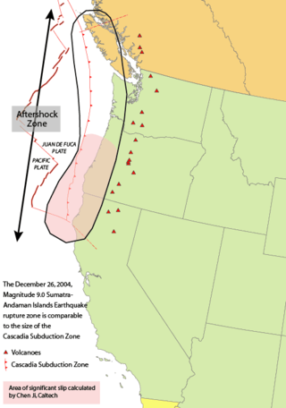
The Cascadia subduction zone is a 960 km fault at a convergent plate boundary, about 112-160 km off the Pacific Shore, that stretches from northern Vancouver Island in Canada to Northern California in the United States. It is capable of producing 9.0+ magnitude earthquakes and tsunamis that could reach 30m. The Oregon Department of Emergency Management estimates shaking would last 5-7 minutes along the coast, with strength and intensity decreasing further from the epicenter. It is a very long, sloping subduction zone where the Explorer, Juan de Fuca, and Gorda plates move to the east and slide below the much larger mostly continental North American Plate. The zone varies in width and lies offshore beginning near Cape Mendocino, Northern California, passing through Oregon and Washington, and terminating at about Vancouver Island in British Columbia.
Megathrust earthquakes occur at convergent plate boundaries, where one tectonic plate is forced underneath another. The earthquakes are caused by slip along the thrust fault that forms the contact between the two plates. These interplate earthquakes are the planet's most powerful, with moment magnitudes (Mw) that can exceed 9.0. Since 1900, all earthquakes of magnitude 9.0 or greater have been megathrust earthquakes.

Many major earthquakes have occurred in the region of the Kamchatka Peninsula in far eastern Russia. Events in 1737, 1923 and 1952, were megathrust earthquakes and caused tsunamis. There are many more earthquakes and tsunamis originating from the region.

The Aleutian Trench is an oceanic trench along a convergent plate boundary which runs along the southern coastline of Alaska and the Aleutian islands. The trench extends for 3,400 kilometres (2,100 mi) from a triple junction in the west with the Ulakhan Fault and the northern end of the Kuril–Kamchatka Trench, to a junction with the northern end of the Queen Charlotte Fault system in the east. It is classified as a "marginal trench" in the east as it runs along the margin of the continent. The subduction along the trench gives rise to the Aleutian Arc, a volcanic island arc, where it runs through the open sea west of the Alaska Peninsula. As a convergent plate boundary, the trench forms part of the boundary between two tectonic plates. Here, the Pacific Plate is being subducted under the North American Plate at a dip angle of nearly 45°. The rate of closure is 7.5 centimetres (3 in) per year.

The seismicity of the Sanriku coast identifies and describes the seismic activity of an area of Japan. Seismicity refers to the frequency, type and size of earthquakes experienced over a period of time. The Sanriku Coast is a descriptive term referring to the coastal areas of the former provinces of Rikuō in Aomori, Rikuchū in Aomori, and Rikuzen in Miyagi.
A slow earthquake is a discontinuous, earthquake-like event that releases energy over a period of hours to months, rather than the seconds to minutes characteristic of a typical earthquake. First detected using long term strain measurements, most slow earthquakes now appear to be accompanied by fluid flow and related tremor, which can be detected and approximately located using seismometer data filtered appropriately. That is, they are quiet compared to a regular earthquake, but not "silent" as described in the past.
The 1952 Severo-Kurilsk earthquake struck off the coast of the Kamchatka Peninsula. The 9.0 Mw earthquake triggered a major tsunami that hit Severo-Kurilsk, Kuril Islands, Sakhalin Oblast, Russian SFSR, USSR, on 5 November 1952 at 04:58 local time. This led to the destruction of many settlements in Sakhalin Oblast and Kamchatka Oblast, while the main impact struck the town of Severo-Kurilsk. It was the most powerful earthquake ever recorded in Russia, and the fifth most powerful earthquake ever recorded in the world since modern seismography began in 1900.
The 2000 New Ireland earthquakes occurred off the coast of New Ireland Province, Papua New Guinea on November 16 and 17.
The 1965 Rat Islands earthquake occurred at 05:01 UTC, on 4 February. It had a magnitude of 8.7 and triggered a tsunami of over 10 m on Shemya Island, but caused very little damage.

The 1978 Miyagi earthquake occurred at 17:14 local time on 12 June. The epicentre was offshore of Miyagi Prefecture, Japan. It had a surface wave magnitude of 7.7, JMA magnitude 7.4, and triggered a small tsunami. The earthquake reached a maximum intensity of Shindo 5 in Sendai and caused 28 deaths and 1,325 injuries.

The 1993 southwest-off Hokkaido earthquake or Okushiri earthquake occurred at 13:17:12 UTC on 12 July 1993 in the Sea of Japan near the island of Hokkaido. It had a magnitude of 7.7 on the moment magnitude scale and a maximum felt intensity of VIII (Severe) on the Mercalli intensity scale. It triggered a major tsunami that caused deaths on Hokkaidō and in southeastern Russia, with a total of 230 fatalities recorded. The island of Okushiri was hardest hit, with 165 casualties from the earthquake, the tsunami and a large landslide.

In seismology, a tsunami earthquake is an earthquake which triggers a tsunami of significantly greater magnitude, as measured by shorter-period seismic waves. The term was introduced by Japanese seismologist Hiroo Kanamori in 1972. Such events are a result of relatively slow rupture velocities. They are particularly dangerous as a large tsunami may arrive at a coastline with little or no warning.
The 1959 Kamchatka earthquake occurred on May 4 at with a moment magnitude of 8.0–8.3, and a surface wave magnitude of 8.25. The epicenter was near the Kamchatka Peninsula, Russian SFSR, USSR. Building damage was reported in Petropavlovsk-Kamchatsky. The maximum intensity was VIII (Damaging) on the Medvedev–Sponheuer–Karnik scale. The intensity in Petropavlovsk-Kamchatsky was about VIII MSK.
The 1993 Kushiro–Oki earthquake was one of two large earthquake to strike the Japanese island of Hōkkaido within the same year. The earthquake with a magnitude of 7.6 Mw or 7.8 MJMA struck at 11:06 UTC or 08:06 pm JST on January 15 near the town of Ashoro. Shaking reached a maximum intensity of IX (Violent) on the Mercalli intensity scale, causing considerable damage, and was felt throughout the island, into northern Honshu, Sakhalin, and the Kuril Islands. As a result of the tremors, two people were killed and more than 600 were wounded.
The Nemuro-Oki earthquake in scientific literature, occurred on June 17 at 12:55 local time. It struck with an epicenter just off the Nemuro Peninsula in northern Hokkaidō, Japan. It measured 7.8–7.9 on the moment magnitude scale (Mw ), 8.1 on the tsunami magnitude scale (Mt ) and 7.4 on the Japan Meteorological Agency magnitude scale (MJMA ).

An earthquake occurred off the coast of the Alaska Peninsula on July 28, 2021, at 10:15 p.m. local time. The large megathrust earthquake had a moment magnitude of 8.2 according to the United States Geological Survey (USGS). A tsunami warning was issued by the National Oceanic and Atmospheric Administration (NOAA) but later cancelled. The mainshock was followed by a number of aftershocks, including three that were of magnitude 5.9, 6.1 and 6.9 respectively.
The 1841 Kamchatka earthquake occurred in the Pacific Ocean on May 17 at 08:00 local time. The earthquake had an epicenter off the Russian Far East's Kamchatka Peninsula. With an estimated moment magnitude of 9.0 or higher, it is one of the largest to strike the region. A large tsunami with up to 15 meters in run-up along the coast.
The 1958 Kuril Islands earthquake or Etorofu earthquake was a Mw 8.3–8.4 earthquake that struck near the Kuril island of Iturup on November 6, 1958, at 22:58 UTC, or 09:58 on the 7th local time. The earthquake occurred as the result of shallow reverse faulting along the Kuril-Kamchatka Trench, and caused Modified Mercalli Intensity (MMI) X (Extreme) shaking, as well as a tsunami 5 m (16 ft) high. Iturup sustained significant damage as a result of the shaking and tsunami, with other locations along the Kuril Islands also reporting strong damage.
