
Makhachkala, previously known as Petrovskoye (1844–1857) and Port-Petrovsk (1857–1921), or by the local Kumyk name of Anji, is the capital and largest city of Dagestan, Russia. The city is located on the Caspian Sea, covering an area of 468.13 square kilometres, with a population of over 623,254 residents, while the urban agglomeration covers over 3,712 square kilometres, with a population of roughly 1 million residents. Makhachkala is the fourth-largest city in the Caucasus, the largest city in the North Caucasus and the North Caucasian Federal District, as well as the third-largest city on the Caspian Sea. The city is extremely ethnically diverse, with a minor ethnic Russian population.
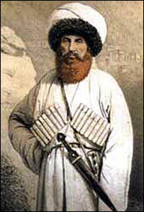
The Avars, also known as Maharuls, are a Northeast Caucasian ethnic group. The Avars are the largest of several ethnic groups living in the Russian republic of Dagestan. The Avars reside in the North Caucasus between the Black Sea and the Caspian Sea. Alongside other ethnic groups in the North Caucasus region, the Avars live in ancient villages located approximately 2,000 meters above sea level. The Avar language spoken by the Caucasian Avars belongs to the family of Northeast Caucasian languages. Sunni Islam has been the prevailing religion of the Avars since the 14th century

Dagestan, officially the Republic of Dagestan, is a republic of Russia situated in the North Caucasus of Eastern Europe, along the Caspian Sea. It is located north of the Greater Caucasus, and is a part of the North Caucasian Federal District. The republic is the southernmost tip of Russia, sharing land borders with the countries of Azerbaijan and Georgia to the south and southwest, the Russian republics of Chechnya and Kalmykia to the west and north, and with Stavropol Krai to the northwest. Makhachkala is the republic's capital and largest city; other major cities are Derbent, Kizlyar, Izberbash, Kaspiysk, and Buynaksk.

Buynaksk is a town in the Republic of Dagestan, Russia, located at the foothills of the Greater Caucasus on the Shura-Ozen River, 40 kilometers (25 mi) southwest of the republic's capital Makhachkala. Population: 62,623 (2010 Russian census); 61,437 (2002 Census); 56,783 (1989 Soviet census); 40,000 (1970).

The Sulak drains most of the mountainous interior of Dagestan northeast into the Caspian Sea. It and most of its branches flow in canyons. Its main tributaries are, from north to southeast:

The Dagestan Oblast was a province (oblast) of the Caucasus Viceroyalty of the Russian Empire. It roughly corresponded to most of present-day southeastern Dagestan within the Russian Federation. The Dagestan oblast was created in 1860 out of the territories of the former Caucasian Imamate, bordering the Terek Oblast to the north, the Tiflis Governorate and Zakatal Okrug to the west, the Elizavetpol Governorate to the south, and Baku Governorate to the east. The administrative center of the oblast was Temir-Khan-Shura.
The 2013 Okhotsk Sea earthquake occurred with a moment magnitude of 8.3 at 15:44:49 local time on 24 May. It had an epicenter in the Sea of Okhotsk and affected primarily Asian Russia, especially the Kamchatka Peninsula where the shaking lasted for five minutes.
The 2002 Tbilisi earthquake occurred on April 25 in the Caucasus country of Georgia. The United States' National Earthquake Information Center (NEIC) placed the magnitude at 4.3 Ms and 4.8 mb . This moderate magnitude event resulted in a maximum MSK intensity of VII to VIII (Damaging). An independent investigation estimated the total losses at $160 million (US) while the Centre for Research on the Epidemiology of Disasters estimated the total losses at 350 million. Between five and seven were killed, 52–70 were injured, and more than 1,000 were left homeless.
The 1992 Murindó earthquake occurred on October 18 at 15:11 UTC with an epicenter in the Department of Chocó, northern Colombia. The shallow magnitude 7.2 earthquake struck northwest of the town of Murindó, killing ten and injured more than a hundred. Thirty-three municipalities were severely damaged.

On May 4, 2018, an earthquake with a magnitude of 6.9 struck Hawaii island in the Hawaii archipelago at around 12:33 p.m. local time. The earthquake's epicenter was near the south flank of Kīlauea, which has been the site of seismic and volcanic activity since late April of that year. According to the United States Geological Survey the quake was related to the new lava outbreaks at the volcano, and it resulted in the Hilina Slump moving about two feet. It was the largest earthquake to affect Hawaii since the 1975 earthquake, which affected the same region, killing two people and injuring another 28.
The 2019 Ridgecrest earthquakes of July 4 and 5 occurred north and northeast of the town of Ridgecrest, California located in Kern County and west of Searles Valley. They included three initial main shocks of magnitudes 6.4, 5.4, and 7.1, and many perceptible aftershocks, mainly within the area of the Naval Air Weapons Station China Lake. Eleven months later, a Mw 5.5 aftershock took place to the east of Ridgecrest. The first main shock occurred on Thursday, July 4 at 10:33 a.m. PDT, approximately 18 km (11.2 mi) ENE of Ridgecrest, and 13 km (8.1 mi) WSW of Trona, on a previously unnoticed NE-SW trending fault where it intersects the NW-SE trending Little Lake Fault Zone. This quake was preceded by several smaller earthquakes, and was followed by more than 1,400 detected aftershocks. The M 5.4 and M 7.1 quakes struck on Friday, July 5 at 4:08 a.m. and 8:19 p.m. PDT approximately 10 km (6 miles) to the northwest. The latter, now considered the mainshock, was the most powerful earthquake to occur in the state in 20 years. Subsequent aftershocks extended approximately 50 km (~30 miles) along the Little Lake Fault Zone.

Aukh District — formed in October 1943 as part of the Dagestan Autonomous Soviet Socialist Republic, in which Chechens-Aukhs lived compactly. In the 19th century, the territory of the district was part of the North Caucasus Imamat where an administrative unit was formed - Aukh. After the end of the Caucasian War, an administrative unit existed at the place of residence of Aukh-Chechens for some time - Aukh district.

An earthquake with a moment magnitude of 7.0 occurred on 30 October 2020 about 14 km (8.7 mi) northeast of the Greek island of Samos. Although Samos was closest to the epicentre, it was the Turkish city İzmir, 70 km (43 mi) northeast that was heavily affected—more than 700 residential and commercial structures were seriously damaged or destroyed. One hundred and seventeen people died in İzmir Province while an additional 1,034 were injured. In Greece, there were two fatalities and 19 injured. The earthquake is the deadliest in the year 2020, and the third major earthquake to strike Turkey that year. The event is called the Samos earthquake by the International Seismological Centre.
The 1990 Gonghe earthquake occurred on April 26 at 17:37 China Standard Time in Hainan Tibetan Autonomous Prefecture, Qinghai Province. The mainshock had a surface wave magnitude of 7.0 Ms and a moment magnitude of 6.5 Mw . It was presaged by two foreshocks that struck merely seconds before the main earthquake. On the Mercalli intensity scale, the earthquake had a rating of IX (Violent).
The 1941 Sa'dah earthquake or the Jabal Razih earthquake occurred on January 11 in Razih District of the Mutawakkilite Kingdom of Yemen. The earthquake had a surface-wave magnitude of 5.8–6.5 and a shallow focal depth. Despite the moderate size of this earthquake, an estimated 1,200 people perished and at least 200 injured. With a maximum MSK-64 intensity assigned at VIII, it destroyed many villages and collapsed homes in the region of North Yemen.

The Diocese of Makhachkala is a diocese of the Russian Orthodox Church on the territory of Dagestan, Ingushetia and Chechnya with its seat in the city of Makhachkala, the capital of the Republic of Dagestan, Russia. The main temple is the Cathedral of the Assumption.
The 1985 Kayrakkum earthquake struck Soviet Tajikistan on October 13 at about 22:00 local time. The earthquake measured Mw 5.8 and struck at a depth of 17.1 km (10.6 mi). At least 29 people died, over 80 were injured and another 8,000 were made homeless. Damage totaled $US200 million. Figures of the casualties were not disclosed until the following month.

Judaism in Dagestan is mainly practiced by Mountain Jews. By the beginning of the 8th century BCE Mountain Jews had reached Persia from Israel. Under the Sasanian Empire, with the arrival in Dagestan of Iranian-speaking tribes from the north, they settled in different regions of the Caucasus.

