The Peru–Chile Trench, also known as the Atacama Trench, is an oceanic trench in the eastern Pacific Ocean, about 160 kilometres (99 mi) off the coast of Peru and Chile. It reaches a maximum depth of 8,065 m (26,460 ft) below sea level in Richards Deep and is approximately 5,900 km (3,666 mi) long; its mean width is 64 km (40 mi) and it covers an expanse of some 590,000 km2 (230,000 sq mi).
Megathrust earthquakes occur at convergent plate boundaries, where one tectonic plate is forced underneath another. The earthquakes are caused by slip along the thrust fault that forms the contact between the two plates. These interplate earthquakes are the planet's most powerful, with moment magnitudes (Mw) that can exceed 9.0. Since 1900, all earthquakes of magnitude 9.0 or greater have been megathrust earthquakes.
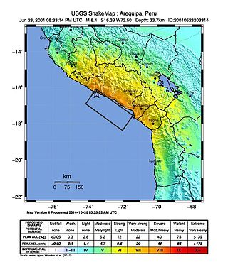
The 2001 southern Peru earthquake occurred at 20:33:15 UTC on June 23 with a moment magnitude of 8.4 and a maximum Mercalli intensity of VIII (Severe). The quake affected the Peruvian regions of Arequipa, Moquegua and Tacna. It was the most devastating earthquake in Peru since the catastrophic 1970 Ancash earthquake and globally the largest earthquake since the 1965 Rat Islands earthquake.
The 1957 Andreanof Islands earthquake occurred at 04:22 local time on March 9 with a moment magnitude estimated between 8.6 and 9.1 and a maximum Modified Mercalli intensity of VIII (Severe). It occurred south of the Andreanof Islands group, which is part of the Aleutian Islands arc. The event occurred along the Aleutian Trench, the convergent plate boundary that separates the Pacific Plate and the North American plates near Alaska. A basin-wide tsunami followed, with effects felt in Alaska and Hawaii, and strong waves recorded across the Pacific rim. Total losses were around $5 million.
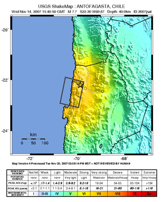
The 2007 Tocopilla earthquake occurred on November 14 at . Its epicenter was located between Quillagua and Tocopilla, affecting the Tarapacá and the Antofagasta regions in northern Chile. The earthquake had a moment magnitude of 7.7 and lasted about 3 minutes and 35 seconds. Seventeen aftershocks of magnitude greater than 5.3, including one of magnitude 7.1 and two others of magnitude 6.3 or higher, were recorded. The Pacific Tsunami Warning Center issued a tsunami warning, stating a tsunami had been generated; after one hour, this warning was cancelled. The earthquake was felt from Santiago, 1,245 km south from the epicenter, to La Paz, about 700 km north-northeast.
The 1995 Antofagasta earthquake occurred on July 30 at 05:11 UTC with a moment magnitude of 8.0 and a maximum Mercalli intensity of VII. The Antofagasta Region in Chile was affected by a moderate tsunami, with three people killed, 58 or 59 injured, and around 600 homeless. Total damage from the earthquake and tsunami amounted to $1.791 million.

The 1868 Arica earthquake occurred on 13 August 1868, near Arica, then part of Peru, now part of Chile, at 21:30 UTC. It had an estimated magnitude between 8.5 and 9.3. A tsunami in the Pacific Ocean was produced by the earthquake, which was recorded in Hawaii, Japan, Australia, and New Zealand.
The 1730 Valparaíso earthquake occurred at 04:45 local time on July 8. It had an estimated magnitude of 9.1–9.3 and triggered a major tsunami with an estimated magnitude of Mt 8.75, that inundated the lower parts of Valparaíso. The earthquake caused severe damage from La Serena to Chillan, while the tsunami affected more than 1,000 km (620 mi) of Chile's coastline.

The 1944 Tōnankai earthquake occurred at 13:35 local time on 7 December. It had an estimated magnitude of 8.1 on the moment magnitude scale and a maximum felt intensity of greater than 5 Shindo. It triggered a large tsunami that caused serious damage along the coast of Wakayama Prefecture and the Tōkai region. Together, the earthquake and tsunami caused 3,358 casualties.
The 1746 Lima–Callao earthquake occurred at on 28 October with a moment magnitude of 8.6–8.8 and a maximum Mercalli intensity of XI (Extreme). The epicenter was located about 90 km (56 mi) north-northwest of the capital Lima, which was almost completely destroyed, and the subsequent tsunami devastated the port city of Callao. It was the deadliest earthquake in Peru’s history prior to the 1970 earthquake.
The November 1960 Peru earthquake occurred offshore northern Peru on November 20 at . The magnitude of the earthquake was Ms 6.75 by using the conventional surface-wave magnitude measurement within a shorter duration of ~20 s. However, there is a large discrepancy between the magnitudes in Ms and Mw in this earthquake. The discrepancy was caused from the earthquake's long source duration of about 130 s, and by calculating the seismic moment, the magnitude would be Mw 7.6 or Mw 7.8, according to different sources. This earthquake belongs to a category of earthquakes with slow rupture velocities and potential of producing tsunamis larger than those expected from the moment magnitudes.
The 1942 Peru earthquake occurred on August 24 at and was located near the border of the departments of Ica and Arequipa, Peru. It had a magnitude of 8.2 or 8.4.
The 2014 Iquique earthquake struck off the coast of Chile on 1 April, with a moment magnitude of 8.2, at 20:46 local time. The epicenter of the earthquake was approximately 95 kilometres (59 mi) northwest of Iquique. The mainshock was preceded by a number of moderate to large shocks and was followed by a large number of moderate to very large aftershocks, including a M7.7 event on 3 April. The megathrust earthquake triggered a tsunami of up to 2.11 metres (6.9 ft) that hit Iquique at 21:05 local time. Similar-sized tsunamis were also reported to have hit the coasts of Pisagua and Arica.
An earthquake measuring 8.0 struck Peru and the surrounding areas on 26 May 2019 at 02:41 local time. It had a maximum perceived intensity of VII on the Modified Mercalli intensity scale in the towns of Yurimaguas and Lagunas. Two people died and a further 30 were injured. It was the strongest earthquake in 2019 by magnitude.
The 1604 Arica earthquake is an earthquake that occurred at 1:30 pm on November 24, 1604, offshore Arica, Chile. The estimated magnitude range is 8.0–8.5 and possibly up to 9.0 . It had a destructive tsunami that destroyed Arica and caused major damage at Arequipa. 1,200 km of coastline were affected by the tsunami. The recorded effects of this earthquake are very similar to those for the 1868 Arica event, suggesting a similar magnitude and rupture area of the megathrust between the subducting Nazca Plate and the overriding South American Plate. Tsunami deposits have been identified on the Chatham Islands that are likely to have been caused by a trans-Pacific tsunami caused by the 1604 earthquake.

An earthquake occurred off the coast of the Alaska Peninsula on July 28, 2021, at 10:15 p.m. local time. The large megathrust earthquake had a moment magnitude of 8.2 according to the United States Geological Survey (USGS). A tsunami warning was issued by the National Oceanic and Atmospheric Administration (NOAA) but later cancelled. The mainshock was followed by a number of aftershocks, including three that were of magnitude 5.9, 6.1 and 6.9 respectively.
The 1586 Lima–Callao earthquake occurred on July 9 along the coast of Peru, near the capital Lima. A section of the Peruvian coast, stretching from Caravelí to Trujillo, north to south, was severely damaged by the earthquake. Major destruction occurred in the capital city Lima as well. The estimated moment magnitude (Mw ) 8.1 earthquake triggered a locally damaging tsunami up to 5 m (16 ft). This was the first major earthquake to strike the city of Lima since its establishment in 1535.
During April 1819, the area around Copiapó in northern Chile was struck by a sequence of earthquakes over a period of several days. The largest of these earthquakes occurred on 11 April at about 15:00 local time, with an estimated magnitude of 8.5. The other two events, on 3 April between 08:00 and 09:00 local time and on 4 April at 16:00 local time, are interpreted as foreshocks to the mainshock on 11 April. The mainshock triggered a tsunami that affected 800 km of coastline and was also recorded at Hawaii. The city of Copiapó was devastated.
The 1950 Calama earthquake occurred near the Argentina–Chile border with an epicenter near Calama, Chile in the Atacama Desert on December 9. The event had a hypocenter depth of 113.9 km, beneath the Caichinque volcanic complex. It measured magnitude Mw 8.2 on the moment magnitude scale, making it the largest intermediate depth earthquake ever recorded on Chilean soil. One person was killed and an unspecified number of people were injured in Calama.
The 1843 Nias earthquake off the northern coast of Sumatra, Indonesia caused severe damage when it triggered a tsunami along the coastline. The earthquake with a moment magnitude (Mw ) of 7.8 lasted nine minutes, collapsing many homes in Sumatra and Nias. It was assigned a maximum modified Mercalli intensity of XI (Extreme).
