Adair, Missouri

Last updated

Adair's location in Adair County indicated by red dot Map of the state of Missouri with a dot indicating the unincorporated community of Adair.jpg
Adair's location in Adair County indicated by red dot

Adair, Missouri is an unincorporated community in eastern Adair County, Missouri, United States. [1] It is located approximately 12 miles northeast of Kirksville, on Missouri Route 11. Adair is notable as the location of St. Mary's Church, which is on the National Register of Historic Places.

History

The first settlers in Adair County, Missouri arrived in 1828 but it was only in the 1830s that they began to branch out to other areas of the county from their original settlement along the Chariton River. [2] By the early 1840s new residents, primarily Irish Catholics by way of Ohio, began to arrive in northeastern Adair County. [3] Their number increased as the Great Famine worsened, causing more Irish to leave their native land for America. By 1860 the populace was enough to support a rough-hewn log church and assignment of a priest. Following the end of the Civil War an attorney from Adair, a Mr. Clancy, wrote glowing editorials to newspapers back in Ohio praising the fine farmland and urging more Irish migration. [3] Among the early settlers was Michael C. Cody, who had previously been involved in the steamboat trade. He arrived in Adair in 1855 and in the late 1860s donated a large tract of land for the village cemetery. Although Adair had yet to be incorporated or even platted, the populace was such that in January, 1878 a United States Post Office was established. [2]

St. Mary's Catholic Church circa 1910 St. Marys Church Adair Missouri-1.JPG
St. Mary's Catholic Church circa 1910

Finally in April, 1879 the village of Adair was platted by Mr. Thomas Dockery at the behest of Mr. Cody and his wife Mary. [4] It was named after its county. [5] By the 1880s Adair's list of business and manufacturing enterprises included a druggist/physician, saw mill, flour mill, hotel, millinery, shoe maker, wagon maker, hoop factory, general store, a livery, and stock dealer. [3] Adair continued to see growth through the remainder of the late 19th and early 20th century, with a population estimated at over 400 by 1905 when the new St. Mary's Catholic Church was completed. One blemish, inexplicable considering the village's growth, was the closing of the Adair Post Office on October 31, 1905. [2] The years after World War I and the Great Depression witnessed large migrations from rural farming to urban industrial areas across America—especially among young adults—and this caused a rapid decline in Adair's population and business offerings. [3] Additionally, much-improved roads meant easier travel to area towns and cities like Baring and Kirksville for supplies. The possibility of an oil boom caused some excitement around Adair, and the region as a whole, in the 1940s. Oil wildcatters drilled a test well near Adair and oil was struck. However it was determined to not be of sufficient quality or quantity to interest major oil companies in further development. [2]

By the 1970s, little remained of Adair. All the businesses had long since closed and perhaps a dozen occupied homes remained. St. Mary's Catholic Church long the backbone of the community, held its final mass in December 1972. [3] A non-profit group, the Friends of St. Mary's, assumed possession of the church in 1976 and have worked to maintain and restore it as funds allow. Adair today has an estimated six residences and population of less than thirty. Only one vacant building of the former business district remains. Law enforcement is provided by the Adair County Sheriff's Department and fire protection by the Eastern Adair Rural Volunteer Fire Department.

Related Research Articles

<span class="mw-page-title-main">Sullivan County, Missouri</span> County in Missouri, United States

Sullivan County is a county located in the northern portion of the U.S. state of Missouri. As of the 2020 census, the population was 5,999. Its county seat is Milan. The county was organized February 14, 1845 and named for Major General John Sullivan of the American Revolutionary War.

<span class="mw-page-title-main">Howard County, Missouri</span> County in Missouri, United States

Howard County is located in the U.S. state of Missouri, with its southern border formed by the Missouri River. As of the 2020 census, the population was 10,151. Its county seat is Fayette. The county was organized January 23, 1816, and named for Benjamin Howard, the first Governor of the Missouri Territory. Settled originally by migrants from the Upper South, it is part of the region historically known as Little Dixie. It is part of the Columbia, Missouri, metropolitan area.

<span class="mw-page-title-main">Adair County, Missouri</span> County in Missouri, United States

Adair County is a county located in the northeastern part of the U.S. state of Missouri. The population census for 2020 was 25,314. As of July 1, 2021, the U.S. Census Bureau's Population Estimates for the county is 25,185, a -0.5% change. Adair county seat is Kirksville. The county was first settled by immigrants from Kentucky and organized on January 29, 1841. Adair County comprises the Kirksville, MO Micropolitan Statistical Area.

<span class="mw-page-title-main">Brashear, Missouri</span> Town in Missouri, United States

Brashear is a city in Salt River Township, Adair County, Missouri, United States. The population was 273 at the 2010 census.

<span class="mw-page-title-main">Gibbs, Missouri</span> Village in Missouri, United States

Gibbs is a village in Wilson Township, Adair County, Missouri, United States. The population was 107 at the 2010 census.

<span class="mw-page-title-main">Kirksville, Missouri</span> City in Missouri, United States

Kirksville is the county seat and most populous city in Adair County, Missouri. Located in Benton Township, its population was 17,530 at the 2020 census. Kirksville is home to two colleges: Truman State University and A.T. Still University.

<span class="mw-page-title-main">Novinger, Missouri</span> Town in Missouri, United States

Novinger is a town in Nineveh Township, Adair County, Missouri, United States. The population was 456 at the 2010 census.

<span class="mw-page-title-main">Kirksville Regional Airport</span> Domestic airport serving Kirksville, Missouri, United States

Kirksville Regional Airport is four miles south of Kirksville, Missouri, on the west side of US highway 63. One airline schedules passenger flights, subsidized by the Essential Air Service program.

<span class="mw-page-title-main">John Miller (Missouri politician)</span> American politician

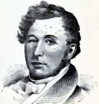
John Miller was an American publisher, War of 1812 veteran, and politician from Missouri. A Democrat, Miller was the fourth Governor of Missouri before serving three terms in the United States House of Representatives from 1837 to 1843.

<span class="mw-page-title-main">Yarrow, Missouri</span> Unincorporated community in the American state of Missouri

Yarrow is an unincorporated community in southwestern Adair County, Missouri, United States. It is located on Missouri Supplemental Route N, approximately ten miles southwest of Kirksville. Yarrow's post office has closed and mail now comes from Kirksville.

<span class="mw-page-title-main">Samuel W. Arnold</span> American politician

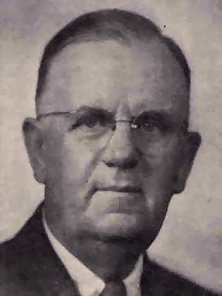
Samuel Washington (Wat) Arnold was a U.S. Representative from Missouri.

<span class="mw-page-title-main">Lingo, Missouri</span> Place in Missouri, United States

Lingo is a community in Macon County, Missouri, 20 miles (32 km) west of the city of Macon. Lingo was platted in 1873. The village was named for an early settler, Samuel Sanders Lingo, who was born August 9, 1805, in South Carolina, and was a prominent figure as county judge in Macon County for 25 years.

<span class="mw-page-title-main">Mid-Missouri</span> Central area of the U.S. state of Missouri

Mid-Missouri is a loosely-defined region comprising the central area of the U.S. state of Missouri. The region's largest city is Columbia ; the Missouri state capital, Jefferson City, and the University of Missouri are also located here. The region also includes portions of the Lake of the Ozarks, the Ozark Mountains, and the Missouri Rhineland. Mid-Missouri is centered on two contiguous metropolitan areas: the Columbia Metropolitan Area and the Jefferson City Metropolitan Area, which together have a population of over 400,000.

<span class="mw-page-title-main">KIRX</span> Radio station in Kirksville, Missouri

KIRX is a radio station licensed to the city of Kirksville, Missouri and serves the northeast Missouri area.

<span class="mw-page-title-main">KTUF</span> Radio station in Kirksville, Missouri

KTUF is a radio station licensed to the city of Kirksville, Missouri, United States, and serves the northeast Missouri and southeast Iowa area.

<span class="mw-page-title-main">Masonic Temple (Kirksville, Missouri)</span> United States historic place

The Masonic Temple in Kirksville, Missouri serves as the home for Kirksville Lodge No. 105 A.F. & A.M., Adair Lodge No. 366 A.F. & A.M., Kirksville Chapter No. 184 O.E.S., Caldwell Chapter No. 53 R.A.M., Kirksville Council No. 44 R.&S.M., and Ely Commandery No. 22 K.T. The structure was listed on the National Register of Historic Places on January 7, 2010.

<span class="mw-page-title-main">St. Mary's Church (Adair, Missouri)</span> Historic church in Missouri, United States

St. Mary's Church is a historic turn-of-the-20th century Catholic church located in the unincorporated community of Adair, 12 miles northeast of Kirksville, Adair County, Missouri, on Missouri Route 11. An example of Romanesque Revival architecture, it is one of the few wood-frame structures in that style still remaining in the United States. St. Mary's was constructed in 1904, and was added to the National Register of Historic Places in 1974. It is now owned and managed by Friends of St. Mary's, a non-profit preservation organization.

Stahl is an unincorporated community in northwest Adair County, Missouri, United States. The community is on Missouri Route O about six miles northwest of Novinger and 12 miles northwest of Kirksville. There are only three houses at Stahl, and an abandoned car dump along the highway. The Union Ridge Conservation Area lies to the west about two miles and Spring Creek flows past the community to its confluence with the Chariton River south of Novinger.

Spring Creek is a stream in Putnam, Sullivan and Adair counties of northern Missouri. It is a tributary of the Chariton River.

References

  1. U.S. Geological Survey Geographic Names Information System: Adair, Missouri
  2. 1 2 3 4 Selby, Paul O. (1976). A Book of Adair County History. Kirksville, Missouri: Kirksville-Adair County Bicentennial Committee. pp. 34–36, 87.
  3. 1 2 3 4 5 Poston, Bobby (April 1981). "It all started with the Irish immigrants" (PDF). The Chariton Collector magazine. Archived from the original (PDF) on July 8, 2010. Retrieved November 17, 2012.
  4. Violette, Eugene Morrow (1911). History of Adair County. Kirksville, Missouri: Denslow History Company. p.  423.
  5. Ramsay, Robert L. (1928–1945). "Adair County". Survey of Missouri Place Names. University of Missouri. Archived from the original on June 26, 2017. Retrieved June 13, 2019.

40°15′08″N92°22′27″W / 40.25222°N 92.37417°W / 40.25222; -92.37417