Millard, Missouri

Last updated

Millard, Missouri
Adair County Missouri Incorporated and Unincorporated areas Millard Highlighted.svg
Location within Adair County (left) and Missouri (right)
Coordinates: 40°06′27″N92°32′45″W / 40.10750°N 92.54583°W / 40.10750; -92.54583
Country United States
State Missouri
County Adair
Township Pettis
Area
[1]
  Total0.12 sq mi (0.31 km2)
  Land0.12 sq mi (0.31 km2)
  Water0.00 sq mi (0.00 km2)
Elevation
[2]
968 ft (295 m)
Population
 (2020)
  Total79
  Density658.33/sq mi (253.28/km2)
Time zone UTC-6 (Central (CST))
  Summer (DST) UTC-5 (CDT)
ZIP code
63501
Area code 660
FIPS code 29-48134 [3]
GNIS feature ID2399350 [2]

Millard is a village in Pettis Township, Adair County, Missouri, United States. The population was 89 at the 2010 census.

Contents

History

Millard was laid out in 1872, and most likely named after Maggie A. Miller, one of the founders. [4] A post office called Millard was established in 1870, and remained in operation until 1942. [5]

Millard Church, built in 1872. It remains the oldest church building still in use in Adair County, Missouri. MillardChurch.jpg
Millard Church, built in 1872. It remains the oldest church building still in use in Adair County, Missouri.

Geography

According to the United States Census Bureau, the village has a total area of 0.12 square miles (0.31 km2), all land. [6]

Demographics

Historical population
CensusPop.Note
1880 123
1980 92
1990 71−22.8%
2000 755.6%
2010 8918.7%
2020 79−11.2%
U.S. Decennial Census [7]

Millard is part of the Kirksville Micropolitan Statistical Area.

2010 census

As of the census [8] of 2010, there were 89 people, 40 households, and 27 families residing in the village. The population density was 741.7 inhabitants per square mile (286.4/km2). There were 45 housing units at an average density of 375.0 per square mile (144.8/km2). The racial makeup of the village was 96.6% White, 1.1% from other races, and 2.2% from two or more races. Hispanic or Latino of any race were 1.1% of the population.

There were 40 households, of which 22.5% had children under the age of 18 living with them, 57.5% were married couples living together, 7.5% had a female householder with no husband present, 2.5% had a male householder with no wife present, and 32.5% were non-families. 30.0% of all households were made up of individuals, and 12.5% had someone living alone who was 65 years of age or older. The average household size was 2.23 and the average family size was 2.70.

The median age in the village was 51.5 years. 23.6% of residents were under the age of 18; 1.2% were between the ages of 18 and 24; 19.1% were from 25 to 44; 40.4% were from 45 to 64; and 15.7% were 65 years of age or older. The gender makeup of the village was 49.4% male and 50.6% female.

2000 census

As of the census [3] of 2000, there were 75 people, 34 households, and 24 families residing in the village. The population density was 606.5 inhabitants per square mile (234.2/km2). There were 39 housing units at an average density of 315.4 per square mile (121.8/km2). The racial makeup of the village was 100.00% White.

There were 34 households, out of which 20.6% had children under the age of 18 living with them, 58.8% were married couples living together, 2.9% had a female householder with no husband present, and 29.4% were non-families. 23.5% of all households were made up of individuals, and 8.8% had someone living alone who was 65 years of age or older. The average household size was 2.21 and the average family size was 2.58.

In the village, the population was spread out, with 17.3% under the age of 18, 4.0% from 18 to 24, 30.7% from 25 to 44, 32.0% from 45 to 64, and 16.0% who were 65 years of age or older. The median age was 44 years. For every 100 females, there were 108.3 males. For every 100 females age 18 and over, there were 100.0 males.

The median income for a household in the village was $25,833, and the median income for a family was $35,625. Males had a median income of $19,375 versus $21,563 for females. The per capita income for the village was $16,458. There were 10.0% of families and 18.3% of the population living below the poverty line, including no under eighteens and 36.4% of those over 64.

Related Research Articles

<span class="mw-page-title-main">Adair, Iowa</span> City in Iowa, United States

Adair is a city in Adair and Guthrie counties of Iowa in the United States. The population was 791 at the 2020 census.

<span class="mw-page-title-main">Fontanelle, Iowa</span> City in Iowa, United States

Fontanelle is a city in Summerset Township, Adair County, Iowa, United States. The population was 676 at the time of the 2020 census.

<span class="mw-page-title-main">Gibbs, Missouri</span> Village in Missouri, United States

Gibbs is a village in Wilson Township, Adair County, Missouri, United States. The population was 107 at the 2010 census.

<span class="mw-page-title-main">Livonia, Missouri</span> Village in Missouri, United States

Livonia is a village in eastern Putnam County, Missouri, United States. The population was 52 at the 2020 census.

<span class="mw-page-title-main">Glenwood, Missouri</span> Village in Missouri, United States

Glenwood is a village in Schuyler County, Missouri, United States. As of the 2020 census, its population was 181. It is part of the Kirksville Micropolitan Statistical Area.

<span class="mw-page-title-main">La Vista, Nebraska</span> City in Sarpy County, Nebraska, United States

La Vista is a city in Sarpy County, Nebraska, United States. The population was 16,746 at the 2020 census, making it the 12th most populous city in Nebraska. The city was incorporated on February 23, 1960.

<span class="mw-page-title-main">Uplands Park, Missouri</span> Village in Missouri, United States

Uplands Park is a village in St. Louis County, Missouri, United States. The population was 445 at the 2010 census. The village is one of many small majority black communities located in the Natural Bridge corridor of mid-St. Louis County, characterized by small homes on small lots.

<span class="mw-page-title-main">Nellie, Ohio</span> Village in Ohio, United States

Nellie is a village in Coshocton County, Ohio, United States, along the Walhonding River. The population was 122 at the 2020 census.

<span class="mw-page-title-main">Cuyahoga Heights, Ohio</span> Village in Ohio, United States

Cuyahoga Heights is a village in Cuyahoga County, Ohio, United States. The population was 573 at the 2020 census. A suburb of Cleveland, it is a part of the Cleveland metropolitan area.

<span class="mw-page-title-main">Hartford, Ohio</span> Village in Ohio, United States

Hartford is a village in the township of the same name in Licking County, Ohio, United States. The population was 404 at the 2020 census.

<span class="mw-page-title-main">Hartville, Ohio</span> Village in Ohio, United States

Hartville is a village in northern Stark County, Ohio, United States. The population was 3,329 at the 2020 census. It is part of the Canton–Massillon metropolitan area. Hartville lies halfway between Akron and Canton at the intersection of State Routes 43 and 619.

<span class="mw-page-title-main">Boston Heights, Ohio</span> Village in Ohio, United States

Boston Heights is a village in northern Summit County, Ohio, United States. The population was 1,402 at the 2020 census. It is part of the Akron metropolitan area. Boston Heights is home to the headquarters of Arhaus, a major home furnishings retailer.

<span class="mw-page-title-main">Christie, Oklahoma</span> CDP in Oklahoma, United States

Christie is a census-designated place (CDP) in Adair County, Oklahoma, United States. The population was 218 at the 2010 census, a 31.3 percent increase over the figure of 166 recorded in 2000.

<span class="mw-page-title-main">Adair Village, Oregon</span> City in Oregon, United States

Adair Village is a city in Benton County, Oregon, United States. The population was 840 at the 2010 census.

<span class="mw-page-title-main">Bellevue, Wisconsin</span> Village in Wisconsin, United States

Bellevue is a village in Brown County, Wisconsin. It was a town until incorporating as a village on February 14, 2003. The population was 15,935 at the time of the 2020 census. Bellevue is part of the Green Bay metropolitan area. Bellevue sits around 4.34 miles (6.99 km) east from central Green Bay.

<span class="mw-page-title-main">Fairwater, Wisconsin</span> Village in Wisconsin, United States

Fairwater is a village in Fond du Lac County, Wisconsin, United States. The population was 371 at the 2010 census. The town of Metomen surrounds the village.

<span class="mw-page-title-main">Avoca, Wisconsin</span> Village in Wisconsin, United States

Avoca is a village in Iowa County, Wisconsin, United States. The population was 637 at the 2010 census. It is part of the Madison Metropolitan Statistical Area. It is named after Avoca in Ireland.

<span class="mw-page-title-main">Greentop, Missouri</span> City in Missouri, United States

Greentop is a city in Adair and Schuyler counties, Missouri, United States. As of the 2020 census, its population was 388.

The village of Moravia in Cayuga County, New York, United States is a community with population of about 1,200. The village of Moravia is in the southern part of the town of Moravia and is south of Auburn.

<span class="mw-page-title-main">Moravia, New York</span> Town in New York, United States

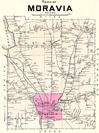
Moravia is a town in Cayuga County, New York. The population was 3,626 at the time of the 2010 census.

References

  1. "ArcGIS REST Services Directory". United States Census Bureau. Retrieved August 28, 2022.
  2. 1 2 U.S. Geological Survey Geographic Names Information System: Millard, Missouri
  3. 1 2 "U.S. Census website". United States Census Bureau . Retrieved January 31, 2008.
  4. "Adair County Place Names, 1928-1945 (archived)". The State Historical Society of Missouri. Archived from the original on June 24, 2016. Retrieved August 30, 2016.{{cite web}}: CS1 maint: bot: original URL status unknown (link)
  5. "Post Offices". Jim Forte Postal History. Retrieved August 27, 2016.
  6. "US Gazetteer files 2010". United States Census Bureau. Archived from the original on July 2, 2012. Retrieved July 8, 2012.
  7. "Census of Population and Housing". Census.gov. Retrieved June 4, 2015.
  8. "U.S. Census website". United States Census Bureau . Retrieved July 8, 2012.

Further reading