Related Research Articles

Adair County is a county located in the northeastern part of the U.S. state of Missouri. The population census for 2020 was 25,314. As of July 1, 2021, the U.S. Census Bureau's Population Estimates for the county is 25,185, a -0.5% change. Adair county seat is Kirksville. The county was first settled by immigrants from Kentucky and organized on January 29, 1841. Adair County comprises the Kirksville, MO Micropolitan Statistical Area.
Olney is an unincorporated community in western Lincoln County, Missouri, United States. It is located on Missouri Supplemental Route O, approximately twelve miles northwest of Troy.

Adair, Missouri is an unincorporated community in eastern Adair County, Missouri, United States. It is located approximately 12 miles northeast of Kirksville, on Missouri Route 11. Adair is notable as the location of St. Mary's Church, which is on the National Register of Historic Places.
Connelsville is an unincorporated community in Nineveh Township, Adair County, Missouri, United States. The community is on Missouri Route 149 about three miles north of Novinger and eight miles northwest of Kirksville. Shuteye Creek flows past the north side of the town and its confluence with the Chariton River is about one mile to the east.
Stahl is an unincorporated community in northwest Adair County, Missouri, United States. The community is on Missouri Route O about six miles northwest of Novinger and 12 miles northwest of Kirksville. There are only three houses at Stahl, and an abandoned car dump along the highway. The Union Ridge Conservation Area lies to the west about two miles and Spring Creek flows past the community to its confluence with the Chariton River south of Novinger.
Shibleys Point is an unincorporated community in Adair County, Missouri, United States.
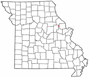
Sublette is an unincorporated community in northern Adair County, Missouri, United States. The community is on U.S. Route 63 about six miles north of Kirksville.
Bullion is an unincorporated community in Adair County, in the U.S. state of Missouri.
Clay is an unincorporated community in Adair County, in the U.S. state of Missouri.
Danforth is an unincorporated community in Adair County, in the U.S. state of Missouri.
Fegley is an unincorporated community in Adair County, in the U.S. state of Missouri.
Lindersville is an extinct town in Adair County, in the U.S. state of Missouri.
Nind is an unincorporated community in Adair County, in the U.S. state of Missouri.
Paultown is an unincorporated community in eastern Adair County, in the U.S. state of Missouri. The community was approximately one mile northeast of Brashear and the Paultown Cemetery is about one-half mile to the east above Big Deer Branch.
Ringo Point is an unincorporated community in Adair County, in the U.S. state of Missouri.
Sperry is an unincorporated community in Adair County, in the U.S. state of Missouri. A fencing business is the only business or service at Sperry; there are also a few homes.
Troy Mills is an unincorporated community in Adair County, in the U.S. state of Missouri.
Willmathsville is an unincorporated community in Adair County, in the U.S. state of Missouri.
Youngstown is an unincorporated community in Adair County, in the U.S. state of Missouri.
Saint Anthony is an unincorporated community in eastern Miller County, in the U.S. state of Missouri. The community is located on Missouri Route A, west of Missouri Route 42 and above Tavern Creek. Brays is on Route 42 to the east and Iberia is 5.5 miles to the south-southwest.
References
- ↑ U.S. Geological Survey Geographic Names Information System: Nineveh, Missouri
- ↑ Violette, E. M. (1911). History of Adair County. The Denslow History Company. pp. 411.
- ↑ "Post Offices". Jim Forte Postal History. Retrieved August 27, 2016.
- ↑ "Adair County Place Names, 1928-1945 (archived)". The State Historical Society of Missouri. Archived from the original on June 24, 2016. Retrieved August 30, 2016.
{{cite web}}: CS1 maint: bot: original URL status unknown (link)
Municipalities and communities of Adair County, Missouri, United States | ||
|---|---|---|
| Cities |  | |
| Villages | ||
| Townships | ||
| CDP | ||
| Other communities | ||
| Ghost towns | ||
| Footnotes | ‡This populated place also has portions in an adjacent county or counties | |
40°16′27″N92°41′41″W / 40.27417°N 92.69472°W
| | This Adair County, Missouri state location article is a stub. You can help Wikipedia by expanding it. |