Administrative divisions of Romania

Last updated

Romania's administration is relatively centralized and administrative subdivisions are therefore fairly simplified.

Contents

According to the Constitution of Romania, its territory is organized administratively into communes, cities and counties: [1]

Below communal or town level, there are no further formal administrative subdivisions. However, communes are divided into villages (which have no administration of their own). There are 12,957 villages in Romania. The only exception is Bucharest, which has six sectors, each with an administration of its own.

Historic

Territorial evolution of Romania, 1859-present (animated map). RomaniaBorderHistoryAnnimation 1859-2010.gif
Territorial evolution of Romania, 1859-present (animated map).
Divisions of Wallachia, 1601-1718 Tara Romaneasca judete 1601-1718.svg
Divisions of Wallachia, 1601-1718
Divisions of Moldavia, 1601-1718 Moldova judete 1601-1718.jpg
Divisions of Moldavia, 1601-1718
Divisions of Transylvania, 1606-1660 Transylvanian Principality.svg
Divisions of Transylvania, 1606-1660

The earliest organization into județe of the Principalities of Wallachia, [3] respectively ținuturi of Moldavia, dates back at least to the early 15th century. Each județ, respectively ținut, was ruled by a jude, respectively pârcălab, an officially appointed person who had administrative and judicial functions in a manner inspired from the organization of the late Byzantine Empire. Transylvania, when it was part of the historic Kingdom of Hungary (in the Middle Ages), an independent Principality or a Habsburg domain (in the modern era until World War I) was divided into royal counties (Latin: comitatus), headed by comes (royal counts) with administrative and judicial functions. The term județ became used in Romanian universally for all principalities since mid-19th century.

Counties of Romania, 1864-1878 Romania administrative divisions, 1864.svg
Counties of Romania, 1864-1878
Counties of Romania, 1878-1913 Romania Judete Antebelice (RO).svg
Counties of Romania, 1878-1913

After modern Romania was formed in 1859 through the union of Wallachia and rump Moldavia, and then extended in 1918 through the union of Transylvania, as well as Bukovina and Bessarabia (parts of Moldavia temporarily acquired by the Habsburgs, 1775–1918, respectively the Russian Tsars, 1812–1917), the administrative division was modernized using the French departments system as an example. With the exception of the half of the Communist period, this system remained in place. Since 1864, for each județ there exists a prefect (from the Latin praefectus ), a subordinate of the Ministry of Internal Affairs, who is the representative of the government in the county, and the head of the local administration in the areas not delegated to local authorities. [4] Until 1948, each județ was further divided into a number of plăși (singular plasă), with each administered by a pretor (from the Latin praetor ), appointed by the prefect. [5]

In 1913, as a result of the Second Balkan War, Romania acquired Southern Dobruja from Bulgaria, integrating this historical region within Romania's borders until 1940. In 1923 Romania adopted a new Constitution, and in 1927 it uniformized the traditional administrative systems of Transylvania, Bukovina and Bessarabia with that of the Romanian Old Kingdom. County borders were kept largely intact, with only a couple minor adjustments, as a total of 71 județe existed between 1927 and 1938.

In 1938, King Carol II modified the Constitution, and after that the law of administration of the Romanian territory. Ten "ținuturi" (approx. translation: "lands") were created, ruled by "Rezidenți Regali" (approx. translation "Royal Residents"), appointed directly by the Monarch. The ținuturi represented another layer of administration between counties and the country; county borders were not erased. [4] [6] But, due to World War II, the Second Vienna Award, the Ribbentrop-Molotov pact and the loss of territory that Romania suffered, this style of administration did not last, the administration at the "județ" level being reintroduced back until the establishment of communism in 1945–1947.

During World War II, the territory of Romania suffered very significant modifications. In 1940, Soviet Union occupied Bessarabia, Northern Bukovina, and Hertsa region which after the fall of the Soviet Union in 1991, would become part of Republic of Moldova and of Ukraine. Between 1941 and 1944, these territories together with Transnistria, were administered by Romania briefly, as the country was governed by a military dictatorship allied with Nazi Germany. Transnistria consisted of formerly proper Soviet territory between Dniester and Southern Bug rivers. Nowadays, most of it is in Ukraine, with small parts in the Republic of Moldova (current Transnistria). This territory was kept under Romanian military occupation, and was not annexed to Romania consisted of a further 13 counties.

Current counties imposed over the inter-war counties Romania Counties 1930-2008.svg
Current counties imposed over the inter-war counties

After the war, the Communist Party took over the administration of the country. In 1950, the party changed the administration model to the Russian model (regions and raions), but it reverted to the current system in 1968, although county borders were quite different from the interbelic period. [7] In 1981 the former counties of Ilfov and Ialomița were re-organised into the present-day counties of Giurgiu, Călărași, Ialomița and Ilfov. The county borders introduced in 1968 are largely in place, but administrative reform during the 1990s has devolved the functions of different authorities in line with transition from a totalitarian communist system to a modern democracy. The only territorial adjustment after 1989 occurred in 1995, when Ilfov County was formed. Before that it was a dependency of the Municipality of Bucharest (Sectorul Agricol Ilfov).

Current status

NUTS 1 regions of Romania Romania NUTS 1.svg
NUTS 1 regions of Romania
NUTS 2 regions of Romania Regiuni de dezvoltare.svg
NUTS 2 regions of Romania
NUTS 3 regions of Romania Romanian license plate codes.png
NUTS 3 regions of Romania

Eight regional divisions (called development regions) were created in 1998 in order to better co-ordinate regional development as Romania progressed towards accession to the European Union, and consist of several counties each. These correspond to NUTS II-level divisions in European Union member states, but do not actually have an administrative status and do not have a legislative or executive council or government. As of 2009, Romania is divided into 41 counties and one municipality which are assigned as NUTS III-level divisions. Currently, Romania has no NUTS-4 units, the counties being composed directly of cities (some of which with municipality status) and communes.

As in all modern democracies, the political power in Romania is divided into three independent branches: legislative, executive, and judicial. The prefect and his administration have only executive prerogatives. However, the territorial districts of the Romanian judicial system overlap with county borders, thus avoiding further complication. [4] At the same time with local elections (of mayors and councilors for the cities and communes), a Consiliu județean (County Council) is elected for each county. From 2008 to 2016 a President of the County Council was also elected by direct vote. Beginning in 2016, the president is (as prior to 2008) elected by a Council. As of now, the legislative powers of county councils are quite reduced, but there are plans for more decentralization. (These plans, however, call for introduction of Regional Councils for the 8 development regions of the NUTS-2 level.)

Future developments

As of 2010 there have been several proposals for the administrative reorganization of Romania made by the presidential commission tasked with the analysis of the political and constitutional regime. [8] Most of these recommendations aim for the partial reestablishment of the counties in their pre-1950 form. The counties will be grouped into several regions (9 to 15) based on common historical and economic characteristics (NUTS II level). The regions will be in their turn clustered into 4-6 macroregions (NUTS I level). Furthermore, a NUTS IV level division, called plasă or canton will probably be added in order to meet the EU statistical and administrative requirements. [9]

Another proposal, based on 15 autonomous euro-regions (amongst them one ethnic based region with a consistent Hungarian majority made of the existing Mureș, Harghita and Covasna counties) grouped into 5 statistical macroregions (NUTS I), was made by the Democratic Union of Hungarians in Romania (UDMR). [10]

Nomenclature of Territorial Units for Statistics (NUTS)

For statistical and development purposes, Romania, in the NUTS scheme, is divided into:

An exception to this structure is the Municipality of Bucharest, which is a secondary division (rather than a tertiary division like other municipalities) and is officially divided into six sectors, each sector having a local government and council.

The eight development regions (specific territorial entities without administrative status or legal personality) represent the framework for collecting specific statistical data, according to the European regulations issued by Eurostat for the Nomenclature of Territorial Units for Statistics (NUTS) II territorial level. According to the Emergency Government Ordinance No 75/2001 on the functioning of the National Institute for Statistics, eight Directorates General for regional statistics have been created, and together with the 34 county directorates for statistics, aim at developing regional statistics. Officially, the eight regions are Nord-Est (North-East), Sud-Est (South-East), Sud - Muntenia (South - Muntenia), Sud-Vest Oltenia (South-West Oltenia), Vest (West), Nord-Vest (North-West), Centru (Centre), and București - Ilfov (Bucharest - Ilfov). The criteria used by NCS for delimiting the regions is a combination of geographical location and homogeneity based on population density. Alternative historical names are also used, but remain unofficial.

notypenamearea, km2population (2021 census) [11] municipalitiesother citiescommunesvillages
1 Nord-Est (development region) 36,8503,226,43617295062,414
1county Bacău County 6,621601,3873585491
2county Botoșani County 4,986392,8212571333
3county Iași County 5,476760,7742393418
4county Neamț County 5,896454,2032378344
5county Suceava County 8,553642,55151198379
6county Vaslui County 5,318374,7003281449
2 Sud-Est (development region) 35,7622,367,98711243551,448
7county Brăila County 4,766281,4521340140
8county Buzău County 6,103404,9792382475
9county Constanța County 7,071655,9973958189
10county Galați County 4,466496,8922261180
11county Tulcea County 8,499193,3551446133
12county Vrancea County 4,857335,3122368331
3 Sud - Muntenia 34,4532,864,33916325192,019
13county Argeș County 6,826569,9323495576
14county Călărași County 5,088283,4582350160
15county Dâmbovița County 4,054479,4042582353
16county Giurgiu County 3,526262,0661251167
17county Ialomița County 4,453250,8163459127
18county Prahova County 4,716695,11921290405
19county Teleorman County 5,790323,5443292231
4 Sud-Vest Oltenia 29,2121,873,60711294082,070
20county Dolj County 7,414599,44234104378
21county Gorj County 5,602314,6852761411
22county Mehedinți County 4,933234,3392361344
23county Olt County 5,498383,28026104377
24county Vâlcea County 5,765341,8612978560
5 Vest (development region) 32,0341,668,92112302811,327
25county Arad County 7,754410,1431968270
26county Caraș-Severin County 8,520246,5882669287
27county Hunedoara County 7,063361,6577755457
28county Timiș County 8,697650,5332889313
6 Nord-Vest (development region) 34,1592,521,79315284031,800
29county Bihor County 7,544551,2974691430
30county Bistrița-Năsăud County 5,355295,9881358235
31county Cluj County 6,674679,1415175420
32county Maramureș County 6,304452,47521163214
33county Satu Mare County 4,418330,6682459220
34county Sălaj County 3,864212,2241357281
7 Centru (development region) 34,1002,271,06720373571,788
35county Alba County 6,242325,9414767656
36county Brașov County 5,363546,6154648149
37county Covasna County 3,710200,0422340122
38county Harghita County 6,639291,9504558235
39county Mureș County 6,714518,1934791464
40county Sibiu County 5,432388,3262953162
8 București-Ilfov 1,8212,259,665183291
41county Ilfov County 1,583542,704-83291
42municipality Bucharest 2381,716,9611---
Total238,39119,053,8151032172,86112,957

See also

Related Research Articles

The history of Moldova can be traced to the 1350s, when the Principality of Moldavia, the medieval precursor of modern Moldova and Romania, was founded. The principality was a vassal of the Ottoman Empire from 1538 until the 19th century. In 1812, following one of several Russian–Turkish wars, the eastern half of the principality, Bessarabia, was annexed by the Russian Empire. In 1918, Bessarabia briefly became independent as the Moldavian Democratic Republic and, following the decision of the Parliament, united with Romania. During the Second World War it was occupied by the Soviet Union which reclaimed it from Romania. It joined the Union as the Moldavian ASSR, until the dissolution of the USSR. In 1991 the country declared independence as the Republic of Moldova.

A county is a geographic region of a country used for administrative or other purposes in some nations. The term is derived from the Old French comté denoting a jurisdiction under the sovereignty of a count (earl) or a viscount. Literal equivalents in other languages, derived from the equivalent of "count", are now seldom used officially, including comté, contea, contado, comtat, condado, Grafschaft, graafschap, and zhupa in Slavic languages; terms equivalent to 'commune' or 'community' are now often instead used.

The 41 județe and the municipality of Bucharest comprise the official administrative divisions of Romania. They also represent the European Union' s NUTS-3 geocode statistical subdivision scheme of Romania.

<span class="mw-page-title-main">Dâmbovița County</span> County of Romania

Dâmbovița County is a county of Romania, in Muntenia, with the capital city at Târgoviște, the most important economic, political, administrative and cultural center of the county. It is a traditional administrative unit, first attested in 1512.

<span class="mw-page-title-main">Moldavian Soviet Socialist Republic</span> Republic of the Soviet Union (1940–1991)

The Moldavian Soviet Socialist Republic or Moldavian SSR, also known as the Moldovan Soviet Socialist Republic, Moldovan SSR, or simply Moldavia or Moldova, was one of the 15 republics of the Soviet Union which existed from 1940 to 1991. The republic was formed on 2 August 1940 from parts of Bessarabia, a region annexed from Romania on 28 June of that year, and parts of the Moldavian Autonomous Soviet Socialist Republic, an autonomous Soviet republic within the Ukrainian SSR.

<span class="mw-page-title-main">Administrative divisions of Moldova</span>

Moldova is divided administratively into two levels:

<span class="mw-page-title-main">Ilfov County</span> County of Romania

Ilfov is the county that surrounds Bucharest, the capital of Romania. It used to be largely rural, but, after the fall of Communism, many of the county's villages and communes developed into high-income commuter towns, which act like suburbs or satellites of Bucharest. The gentrification of the county is continuing, with many towns in Ilfov, such as Otopeni, having some of the highest GDP per capita levels in the country.

<span class="mw-page-title-main">Development regions of Romania</span> Overview article

The development regions of Romania refer to the eight regional divisions created in Romania in 1998 in order to better co-ordinate regional development as Romania progressed towards accession to the European Union (EU). The development regions correspond to NUTS 2-level divisions in EU member states. Despite becoming increasingly significant in regional development projects, Romania's development regions do not actually have an administrative status and do not have a legislative or executive council or government. Rather, they serve a function for allocating EU PHARE funds for regional development, as well as for collection of regional statistics. They also co-ordinate a range of regional development projects and became members of the Committee of the Regions when Romania joined the EU on January 1, 2007.

<span class="mw-page-title-main">Historical regions of Romania</span>

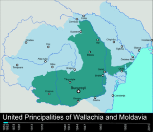
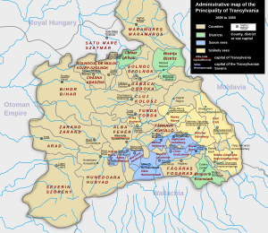
The historical regions of Romania are located in Central, Southeastern, and Eastern Europe. Romania came into being through the unification of two principalities, Wallachia and Moldavia in 1862. The new unitary state extended over further regions at various times during the late 19th and 20th centuries, including Dobruja in 1878, and Transylvania in 1918.

A județ is an administrative division in Romania, and was also used from 1940 to 1947 in the Moldavian Soviet Socialist Republic and from 1998 to 2003 in Moldova.

<span class="mw-page-title-main">Hertsa region</span> Ukrainian region composed of the Hertsa town and its surroundings

The Hertsa region, also known as the Hertza region, is a region around the town of Hertsa within Chernivtsi Raion in the southern part of Chernivtsi Oblast in southwestern Ukraine, near the border with Romania. With an area of around 304 km2 (117 sq mi), it has a population of about 32,300 people, 93% of whom are ethnic Romanians.

<span class="mw-page-title-main">Hotin County</span> County in Romania

Hotin County was a county in the Principality of Moldavia (1359–1812), the Governorate of Bessarabia (1812–1917), the Moldavian Democratic Republic (1917–1918), and the Kingdom of Romania.

The union of Bessarabia with Romania was proclaimed on April 9 [O.S. March 27] 1918 by Sfatul Țării, the legislative body of the Moldavian Democratic Republic. This state had the same borders of the region of Bessarabia, which was annexed by the Russian Empire following the Treaty of Bucharest of 1812 and organized first as an Oblast and later as a Governorate. Under Russian rule, many of the native Tatars were expelled from parts of Bessarabia and replaced with Moldavians, Wallachians, Bulgarians, Ukrainians, Greeks, Russians, Lipovans, Cossacks, Gagauzes and other peoples, although colonization was not limited to formerly Tatar-inhabited lands. Russia also tried to integrate the region by imposing the Russian language in administration and restricting education in other languages.

<span class="mw-page-title-main">Counties of Romania</span>

A total of 41 counties, along with the municipality of Bucharest, constitute the official administrative divisions of Romania. They represent the country's NUTS-3 statistical subdivisions within the European Union and each of them serves as the local level of government within its borders. Most counties are named after a major river, while some are named after notable cities within them, such as the county seat.

<span class="mw-page-title-main">Bălți County (Romania)</span> County in Romania

Bălți County was a county in the Kingdom of Romania between 1925 and 1938 and between 1941 and 1944, with the seat at Bălți.

In the NUTS codes of Romania (RO), the three levels are:

This article discusses the administrative divisions of the Kingdom of Romania between 1941 and 1944. As a result of the Soviet occupation of Bessarabia and Northern Bukovina, Second Vienna Award and the Treaty of Craiova, territories that had previously been part of Romania were lost to the Soviet Union, Hungary and Bulgaria respectively. By September 1940 the administrative system set up in 1938 based on 'ținuturi' (regions) was disbanded and the former counties (județe) were reintroduced.

<span class="mw-page-title-main">Development of the administrative divisions of Ukraine</span>

Administrative divisions development in Ukraine reviews the history of changes in the administrative divisions of Ukraine, in chronological order.

A new territorial division of the Romanian People's Republic was introduced in 1950. Following the Soviet model, a structure of regions and raions (districts) was created, replacing the former system of județe (counties) and their subdivisions. Further changes were implemented during the 1950s and 1960s.

<span class="mw-page-title-main">Bessarabia Governorate (Romania)</span> Romanian autonomous province existent during World War II

The Bessarabia Governorate was an administrative unit of Romania during World War II.

References

  1. Constitution of Romania, Title I, article 3
  2. 2017 Romanian Statistical Yearbook, p. 17
  3. "De la sat la județ în istoria Olteniei | Vertical". Verticalonline.ro. 8 September 2009. Retrieved 2010-07-08.
  4. 1 2 3 "Instituția Prefectului județul Argeș". Prefecturaarges.ro:8080. Archived from the original on 2012-05-20. Retrieved 2010-07-08.
  5. Sorin Damian. "Județul Buzău". Buzau.com. Archived from the original on 2009-02-14. Retrieved 2010-07-08.
  6. (in Romanian) Ioan Scurtu, Theodora Stănescu-Stanciu, Georgiana Margareta Scurtu, Istoria românilor între anii 1918-1940: VIII. Viața politică în perioada februarie 1938-septembrie 1940 ("The History of the Romanians in 1918-1940): IV. Political Life in the February 1938-September 1940 Period" Archived November 16, 2007, at the Wayback Machine : "Decret-lege pentru reforma electorală" ("Law Decree for Electoral Reform") Archived 2007-07-01 at the Wayback Machine
  7. "Istoria Banatului :: În linii mari". Vestul.ro. 1944-08-23. Archived from the original on 2013-05-21. Retrieved 2010-07-08.
  8. "Microsoft Word - RAPORTUL STANOMIR.doc" (PDF). Archived (PDF) from the original on 15 August 2010. Retrieved 2010-07-08.
  9. "Romania libera - stiri iesite din tipar - actualitate, investigatii, politica, cultura, diaspora, video, anunturi de mica publicitate". Archived from the original on May 23, 2014. Retrieved March 24, 2010.[ dead link ]
  10. Dumitriu, Raluca (October 14, 2007). "Reorganizare teritorială marca UDMR: 15 euroregiuni cu 15 Parlamente" [Territorial reorganization of the UDMR brand: 15 Euroregions with 15 Parliaments]. Gândul (in Romanian). Archived from the original on April 21, 2010. Retrieved March 24, 2010.
  11. "Population at the censuses 1948, 1956, 1966, 1977, 1992, 2002, 2011 and 2021" (in Romanian). INSSE . Retrieved 15 May 2024.