
Romania is a country at the crossroads of Central, Eastern and Southeast Europe. It borders Ukraine to the north and east, Hungary to the west, Serbia to the southwest, Bulgaria to the south, Moldova to the east, and the Black Sea to the southeast. It has a predominantly continental climate, and an area of 238,397 km2 (92,046 sq mi), with a population of 19 million people (2023). Romania is the twelfth-largest country in Europe and the sixth-most populous member state of the European Union. Its capital and largest city is Bucharest, followed by Iași, Cluj-Napoca, Timișoara, Constanța, Craiova, Brașov, and Galați.

With an area of 238,397 km2 (92,046 sq mi), Romania is the twelfth-largest country in Europe. It is a Balkan country located at the crossroads of Central, Eastern and Southeast Europe. It's bordered on the Black Sea, the country is halfway between the equator and the North Pole and equidistant from the westernmost part of Europe—the Atlantic Coast—and the most easterly—the Ural Mountains. Romania has 3,195 kilometres (1,985 mi) of border. Republic of Moldova and Ukraine lies to the east, Bulgaria lies to the south, and Serbia and Hungary to the west. In the southeast, 245 kilometres (152 mi) of sea coastline provide an important outlet to the Black Sea and the Atlantic Ocean.
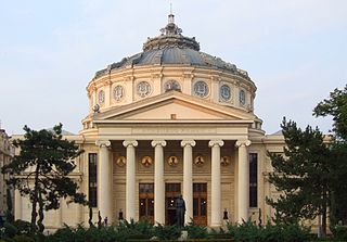
Bucharest is the capital and largest city of Romania. It is described as the cultural, financial, entertainment, and media center in the country with a significant influence in Eastern and Southeastern Europe as well. In geopolitical regards, Bucharest has been and still is an important capital of a state situated in Central and Eastern Europe, where noteworthy summits had taken place. It is also a city with a significant influence in terms of education, tourism, research, technology, health care, art, fashion, sports, and politics. Bucharest is a major economic center in Romania, with a diverse and growing economy that includes industries such as IT, finance, and manufacturing. The city has also seen significant investment in infrastructure, with new roads, bridges, and public transportation systems being built to improve connectivity and mobility. It is located in the south-east of Romania, on the banks of the Dâmbovița river, less than 60 km (37.3 mi) north of the Danube River and the border with Bulgaria. It is also one of the most populated cities of the European Union (EU) within city limits and the most populated capital in Southeastern Europe. It was the capital of Wallachia from 1659 to 1859 and the capital of the United Principalities of Moldavia and Wallachia from 1859 to 1881.

The Carpathian Mountains or Carpathians are a range of mountains forming an arc across Central Europe. Roughly 1,500 km (930 mi) long, it is the third-longest European mountain range after the Urals at 2,500 km (1,600 mi) and the Scandinavian Mountains at 1,700 km (1,100 mi). The range stretches from the far eastern Czech Republic (3%) and Austria (1%) in the northwest through Slovakia (21%), Poland (10%), Ukraine (10%), Romania (51%) to Serbia (5%) in the south. The highest range within the Carpathians is known as the Tatra mountains in Poland and Slovakia, where the highest peaks exceed 2,600 m (8,500 ft). The second-highest range is the Southern Carpathians in Romania, where the highest peaks range between 2,500 m (8,200 ft) and 2,550 m (8,370 ft).

Moldavia is a historical region and former principality in Central and Eastern Europe, corresponding to the territory between the Eastern Carpathians and the Dniester River. An initially independent and later autonomous state, it existed from the 14th century to 1859, when it united with Wallachia as the basis of the modern Romanian state; at various times, Moldavia included the regions of Bessarabia, all of Bukovina and Hertsa. The region of Pokuttya was also part of it for a period of time.

The Tisza, Tysa or Tisa, is one of the major rivers of Central and Eastern Europe. Once, it was called "the most Hungarian river" because it flowed entirely within the Kingdom of Hungary. Today, it crosses several national borders.

Argeș County is a county (județ) of Romania, in Muntenia, with the capital city at Pitești.

Chernivtsi Oblast, also referred to as Chernivechchyna (Чернівеччина), is an oblast (province) in western Ukraine, consisting of the northern parts of the historical regions of Bukovina and Bessarabia. It has an international border with Romania and Moldova. The region spans 8,100 square kilometres (3,100 sq mi). The oblast is the smallest in Ukraine both by area and population. It has a population of 890,457, and its administrative center is the city of Chernivtsi.

The Mureș or Maros is a 789-kilometre-long (490 mi) river in Eastern Europe. Its drainage basin covers an area of 30,332 km2 (11,711 sq mi). It originates in the Hășmașu Mare Range in the Eastern Carpathian Mountains, Romania, rising close to the headwaters of the river Olt, and joins the Tisza at Szeged in southeastern Hungary. In Romania, its length is 761 km (473 mi) and its basin size is 27,890 km2 (10,770 sq mi).

The Siret or Sireth is a river that rises from the Carpathians in the Northern Bukovina region of Ukraine, and flows southward into Romania before it joins the Danube. It is 647 km (402 mi) long, of which 559 km (347 mi) in Romania, and its basin area is 44,811 km2 (17,302 sq mi), of which 42,890 km2 (16,560 sq mi) in Romania. Its average discharge is 250 m3/s (8,800 cu ft/s). In ancient times, it was named Hierasus.

River monitors are military craft designed to patrol rivers.

Ilfov is the county that surrounds Bucharest, the capital of Romania. It used to be largely rural, but, after the fall of Communism, many of the county's villages and communes developed into high-income commuter towns, which act like suburbs or satellites of Bucharest. The gentrification of the county is continuing, with many towns in Ilfov, such as Otopeni, having some of the highest GDP per capita levels in the country.

The Someș or Szamos is a left tributary of the Tisza in Hungary and Romania. It has a length of 415 km (258 mi), of which 50 km are in Hungary. The Someș is the fifth largest river by length and volume in Romania. The hydrographic basin forms by the confluence at Mica, a commune about 4 km upstream of Dej, of Someșul Mare and Someșul Mic rivers. Someșul Mic originates in the Apuseni Mountains, and Someșul Mare springs from the Rodna Mountains.

The Buzău is a river in eastern Romania, tributary of the river Siret. Its total length is 302 km, and its drainage basin area is 5,264 km2. Its source is in the south-eastern Carpathian Mountains, east of Brașov. The Buzău flows through the Romanian counties Brașov, Covasna, Buzău and Brăila. It flows into the Siret in Voinești, close to its confluence with the Danube, west of Galați.
The Peceneaga is a river in Romania, right tributary of the Danube. It flows into Lake Peceneaga, which is connected with the Danube, in the village Peceneaga. Its length is 19 km (12 mi).
The Taița is a river in Tulcea County, Romania. North of the town Babadag it discharges into Lake Babadag, which is connected with Lake Razim, a former lagoon of the Black Sea. Its length is 57 km (35 mi) and its basin size is 591 km2 (228 sq mi).

The Hungarian–Romanian War was fought between Hungary and Romania from 13 November 1918 to 3 August 1919. The conflict had a complex background, with often contradictory motivations for the parties involved.

The Danube is the second-longest river in Europe, after the Volga in Russia. It flows through much of Central and Southeastern Europe, from the Black Forest south into the Black Sea. A large and historically important river, it was once a frontier of the Roman Empire. In the 21st century, it connects ten European countries, running through their territories or marking a border. Originating in Germany, the Danube flows southeast for 2,850 km (1,770 mi), passing through or bordering Austria, Slovakia, Hungary, Croatia, Serbia, Romania, Bulgaria, Moldova, and Ukraine. Among the many cities on the river are four national capitals: Vienna, Bratislava, Budapest, and Belgrade. Its drainage basin amounts to 817,000 km² and extends into nine more countries.

A total of 41 counties, along with the municipality of Bucharest, constitute the official administrative divisions of Romania. They represent the country's NUTS-3 statistical subdivisions within the European Union and each of them serves as the local level of government within its borders. Most counties are named after a major river, while some are named after notable cities within them, such as the county seat.
The Prut is a 953 km (592 mi) long river in Eastern Europe. It is a left tributary of the Danube. In part of its course it forms Romania's border with Moldova and Ukraine.


