
Sabine Parish is a parish located in the U.S. state of Louisiana. As of the 2010 census, the population was 24,233. The seat of the parish is Many.

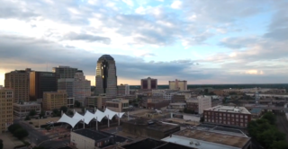
Natchitoches Parish is a parish located in the U.S. state of Louisiana. As of the 2010 census, the population was 39,566. The parish seat is Natchitoches. The parish was formed in 1805.

Loreauville is a village in Iberia Parish in the U.S. state of Louisiana. The population was 887 at the 2010 census, down from 938 at the 2000 census. It is part of the New Iberia micropolitan statistical area, and the Lafayette metropolitan statistical area.

Robeline is a village in western Natchitoches Parish, Louisiana, United States. The population was 183 at the 2000 census. It is part of the Natchitoches Micropolitan Statistical Area.
The Ark-La-Tex is a socio-economic tri-state region where the Southern U.S. states of Arkansas, Louisiana, and Texas join together. The region contains portions of Northwest Louisiana, Northeast Texas, and South Arkansas as well as the extreme southeastern tip of Oklahoma, in McCurtain County, partly centered upon the Red River, which flows along the Texas–Oklahoma state line into Southwestern Arkansas and Northwest Louisiana.
U.S. Route 425 (US 425) is a north–south United States highway that travels in the U.S. states of Mississippi, Louisiana, and Arkansas. It was first commissioned in 1989.

Sugartown is an unincorporated community and census-designated place in Beauregard Parish, Louisiana, United States, approximately 16 miles (26 km) east of DeRidder. As of the 2010 census it had a population of 54. The geographical center of Sugartown today is posted as the intersection of LA 112 and LA 113. The original community was much larger.

Louisiana Highway 9 (LA 9) is a state highway located in northern Louisiana. It runs 100.01 miles (160.95 km) in a north–south direction from the concurrent U.S. Highways 71 and 84 (US 71-84) in Campti to a junction with the concurrent US 63 and US 167 in Junction City.
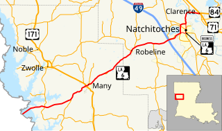
Louisiana Highway 6 (LA 6) is a state highway located in western central Louisiana. It runs 54.52 miles (87.74 km) in an east–west direction from the Texas state line southwest of Many to U.S. Highway 71 (US 71) and U.S. Highway 84 (US 84) in Clarence.
Marthaville is an unincorporated community of just over 1,000 people in Natchitoches Parish, Louisiana, United States. It is part of the Natchitoches Micropolitan Statistical Area.

Cloutierville is an unincorporated community in Natchitoches Parish, Louisiana, United States. It lies approximately 20 miles (32 km) south of the city of Natchitoches on the Cane River. The community is part of the Natchitoches Micropolitan Statistical Area, off exit 119 of Interstate 49.
Roy is an unincorporated community located approximately two miles south of Castor in Bienville Parish in northern Louisiana, United States. To the south of Roy is Ashland in Natchitoches Parish. Named for Roy Otis Martin, Sr. (1890-1973), the community was the location of a closed sawmill owned and operated by the Martin Timber Company based in Alexandria, Louisiana, and operated by Martin's son, Roy O. Martin, Jr., and then his grandson, Roy O. Martin, III until sold to Hunt Plywood in 1992.
Chopin is an unincorporated community in Natchitoches Parish, Louisiana, United States. It is located approximately 19 miles (31 km) southeast of Natchitoches, and Interstate 49 intersects Louisiana Highway 490 near this community. It was likely named after an early French colonial settler.
Allen is an unincorporated community in Natchitoches Parish, Louisiana, United States. It is located approximately 11 miles northwest of Natchitoches near the intersection of Interstate 49 and Louisiana Highway 485.
Flora is an unincorporated community in Natchitoches Parish, Louisiana, United States. It is located near the intersection of Louisiana highways 120 and 478, south of Natchitoches.
Grand Bayou is an unincorporated community in west central Red River Parish, Louisiana, United States. It is located near the intersection of Louisiana Highway 1 and U.S. Highway 84. The community can also be reached by using exit 172 of Interstate 49 in De Soto Parish and traveling north into Red River Parish.
Dry Creek is a rural unincorporated community in the east-central portion of Beauregard Parish, Louisiana, United States. It lies 20 miles (32 km) southeast of DeRidder on the corner of Louisiana highways 113 and 394. Dry Creek is 104 feet (32 m) above sea level.

Creston is an unincorporated community in Natchitoches Parish, Louisiana, United States. Creston is not included in the 2010 United States Census. The community is part of the Natchitoches Micropolitan Statistical Area.


