
Vernon Parish is a parish located in the U.S. state of Louisiana. As of the 2020 census, the population was 48,750. The parish seat is Leesville. Bordered on the west by the Sabine River, the parish was founded in 1871 during the Reconstruction era.

St. Tammany Parish is a parish located in the U.S. state of Louisiana named after Tamanend, the legendary Lenape Chief of Chiefs and the "Patron Saint of America." At the 2020 census, the population was 264,570, making it the fourth-most populous parish in Louisiana. The parish seat is Covington. The parish was founded in 1810.
St. John the Baptist Parish is a parish located in the U.S. state of Louisiana. At the 2020 census, the population was 42,477. The parish seat is Edgard, an unincorporated area, and the largest city is LaPlace, which is also unincorporated.
St. Bernard Parish is a parish in the U.S. state of Louisiana. The parish seat and largest community is Chalmette. The parish was formed in 1807. St. Bernard Parish is part of the New Orleans–Metairie metropolitan statistical area; the parish is located southeast of the city of New Orleans and comprises the Chandeleur Islands and Chandeleur Sound in the east.

Sabine Parish is a parish located in the U.S. state of Louisiana. As of the 2020 census, the population was 22,155. The seat of the parish is Many.

Natchitoches Parish is a parish located in the U.S. state of Louisiana. As of the 2020 census, the population was 37,515. The parish seat is Natchitoches. The parish was formed in 1805.
DeSoto Parish is a parish located in the U.S. state of Louisiana. The parish was formed in 1843. At the 2020 U.S. census, the population was 26,812. Its parish seat is Mansfield. DeSoto Parish is part of the Shreveport–Bossier City metropolitan statistical area.

Claiborne Parish is a parish located in the northwestern section of the U.S. state of Louisiana. The parish was formed in 1828, and was named for the first Louisiana governor, William C. C. Claiborne. As of the 2020 census, the population was 14,170. The parish seat is Homer.

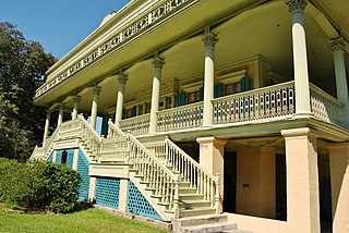
Natchitoches is a small city and the parish seat of Natchitoches Parish, Louisiana, United States. Established in 1714 by Louis Juchereau de St. Denis as part of French Louisiana, the community was named after the indigenous Natchitoches people.

Black Lake is a reservoir located between Creston and Campti in North Louisiana. Water feeds into Black Lake from Black Lake Bayou, a watershed that extends from north of Gibsland in Bienville Parish and south to Clarence in Natchitoches Parish through the parishes of Claiborne, Webster, Bienville, Red River and Natchitoches. The elevation of the lake is 102 feet (31 m). Louisiana Highway 9 runs across Black Lake. On the west side of Highway 9 the body of water is called Black Lake — the east is called Clear Lake or Clear Lake Bayou. The Clear Lake side is near another body of water: Saline Lake. Between Clear Lake and Saline Lake is the Alan Chiverly Dam, constructed in 1934. Road 1226 also extends between the lakes. The full area of the lake is 13,500 acres. Black Lake itself is shallow so in cold temperatures the fish head to Clear Lake and continue on towards Black Bayou as the weather gets colder so that in colder months the fish can be found only in deeper waters. Most of the crappie found at Black Lake are black crappie.
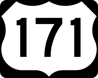
U.S. Highway 171 (US 171) is a part of the United States Numbered Highway System and the only route within that system currently located entirely within the state of Louisiana. It spans 177.44 miles (285.56 km) in a north–south direction from the junction of US 90 and Louisiana Highway 14 (LA 14) in Lake Charles to the junction of US 79/US 80 and LA 3094 in Shreveport.

The Neutral Ground was a disputed area between Spanish Texas and the United States' newly acquired Louisiana Purchase. Local officers of Spain and the United States agreed to leave the Neutral Ground temporarily outside the jurisdiction of either country. The area, now in western Louisiana, had neutral status from 1806 to 1821.

Louisiana Highway 1 (LA 1) is a state highway in Louisiana. At 431.88 miles (695.04 km), it is the longest numbered highway of any class in Louisiana. It runs diagonally across the state, connecting the oil and gas fields near the island of Grand Isle with the northwest corner of the state, north of Shreveport.

Louisiana Highway 9 (LA 9) is a state highway located in northern Louisiana. It runs 100.01 miles (160.95 km) in a north–south direction from the concurrent U.S. Highways 71 and 84 (US 71-84) in Campti to a junction with the concurrent US 63 and US 167 in Junction City.

Louisiana Highway 6 (LA 6) is a state highway located in western central Louisiana. It runs 54.52 miles (87.74 km) in an east–west direction from the Texas state line southwest of Many to U.S. Highway 71 (US 71) and U.S. Highway 84 (US 84) in Clarence.
Grand Bayou is an unincorporated community in west central Red River Parish, Louisiana, United States. It is located near the intersection of Louisiana Highway 1 and U.S. Highway 84. The community can also be reached by using exit 172 of Interstate 49 in De Soto Parish and traveling north into Red River Parish.
Dry Creek is a rural unincorporated community in the east-central portion of Beauregard Parish, Louisiana, United States. It lies 20 miles (32 km) southeast of DeRidder on the corner of Louisiana highways 113 and 394. Dry Creek is 104 feet (32 m) above sea level.

The 2000 United States presidential election in Louisiana took place on November 7, 2000, and was part of the 2000 United States presidential election. Voters chose nine representatives, or electors to the Electoral College, who voted for president and vice president.


