Clarence, Louisiana

Last updated

Clarence, Louisiana
Village of Clarence
Natchitoches Parish Louisiana Incorporated and Unincorporated areas Clarence Highlighted.svg
Location of Clarence in Natchitoches Parish, Louisiana.
USA Louisiana location map.svg
Red pog.svg
Clarence, Louisiana
Usa edcp location map.svg
Red pog.svg
Clarence, Louisiana
Coordinates: 31°49′13″N93°01′44″W / 31.82028°N 93.02889°W / 31.82028; -93.02889
CountryUnited States
States Louisiana
Parish Natchitoches
Area
[1]
  Total1.58 sq mi (4.08 km2)
  Land1.57 sq mi (4.07 km2)
  Water0.00 sq mi (0.01 km2)
Population
 (2020)
  Total326
  Rank NC: 5th
  Density207.38/sq mi (80.09/km2)
Time zone UTC-6 (CST)
  Summer (DST) UTC-5 (CDT)
ZIP code
71414
Area code 318

Clarence is a village in Natchitoches Parish, Louisiana, United States. The population was 499 at the 2010 census. It is located some seven miles east of the parish seat of Natchitoches and is part of the Natchitoches Micropolitan Statistical Area.

Contents

History

Clarence Baptist Church Clarence, LA, Baptist Church IMG 1896.JPG
Clarence Baptist Church

The Harrisonburg Road or the Natchez Trace ran through the area as it crossed Louisiana into Texas to connect with the El Camino Real.

Demographics

Historical population
CensusPop.Note
1960 286
1970 44856.6%
1980 61236.6%
1990 577−5.7%
2000 516−10.6%
2010 499−3.3%
2020 326−34.7%
U.S. Decennial Census [2]

2020 census

Clarence racial composition [3]
RaceNumberPercentage
White (non-Hispanic)6921.17%
Black or African American (non-Hispanic)23973.31%
Native American 30.92%
Other/Mixed 133.99%
Hispanic or Latino 20.61%

As of the 2020 United States census, there were 326 people, 131 households, and 58 families residing in the village.

2010 census

At the 2010 census [4] , there were 499 people, 186 households and 136 families residing in the village. The population density was 311.9 inhabitants per square mile (120.4/km2). There were 204 housing units at an average density of 127.5 per square mile (49.2/km2). The racial makeup of the village was 23.2% White, 75.2% African American, and 1.2% from two or more races. Hispanic or Latino of any race were 2.2% of the population.

There were 186 households, of which 36% had children under the age of 18 living with them, 37.1% were married couples living together, 30.6% had a female householder with no husband present, and 26.9% were non-families. 22% of all households were made up of individuals, and 9.1% had someone living alone who was 65 years of age or older. The average household size was 2.68 and the average family size was 3.13.

Age distribution was 29.1% under the age of 18, 9.3% from 18 to 24, 21.6% from 25 to 44, 28% from 45 to 64, and 12.0% who were 65 years of age or older. The median age was 36.5 years. For every 100 females, there were 87.6 males. For every 100 females age 18 and over, there were 78.5 males.

At the 2000 census [5] The median household income was $25,278, and the median family income was $25,694. Males had a median income of $24,375 versus $17,841 for females. The per capita income for the village was $13,360. About 27.9% of families and 28.3% of the population were below the poverty line, including 36.9% of those under age 18 and 40.0% of those age 65 or over.

Geography

Clarence is located at 31°49′13″N93°1′44″W / 31.82028°N 93.02889°W / 31.82028; -93.02889 (31.820143, 93.028773). [6]

According to the United States Census Bureau, the village has a total area of 1.6 square miles (4.1 km2), all land.

Climate

Climate is characterized by relatively high temperatures and evenly distributed precipitation throughout the year. The Köppen Climate Classification subtype for this climate is "Cfa". (Humid Subtropical Climate). [7]

Climate data for Clarence, Louisiana
MonthJanFebMarAprMayJunJulAugSepOctNovDecYear
Mean daily maximum °C (°F)15
(59)
17
(63)
22
(71)
26
(79)
29
(85)
33
(91)
34
(94)
34
(94)
32
(89)
27
(80)
21
(69)
17
(62)
26
(78)
Mean daily minimum °C (°F)3
(38)
4
(40)
8
(46)
12
(54)
17
(62)
21
(69)
22
(72)
22
(71)
18
(65)
12
(54)
7
(45)
4
(39)
13
(55)
Average precipitation mm (inches)130
(5.1)
120
(4.7)
120
(4.9)
120
(4.6)
130
(5.2)
110
(4.2)
89
(3.5)
76
(3.0)
84
(3.3)
97
(3.8)
110
(4.5)
130
(5.3)
1,316
(52.1)
Source: Weatherbase [8]

Related Research Articles

<span class="mw-page-title-main">West Modesto, California</span> Census-designated place in California, United States

West Modesto is a census-designated place (CDP) in Stanislaus County, California, United States. The population was 5,682 at the 2010 census, down from 6,096 at the 2000 census. It is part of the Modesto Metropolitan Statistical Area.

<span class="mw-page-title-main">Delta, Louisiana</span> Village in Louisiana, United States

Delta is a village in Madison Parish, Louisiana, United States. The population was 232 at the 2020 census. It is part of the Tallulah Micropolitan Statistical Area.

<span class="mw-page-title-main">Ashland, Natchitoches Parish, Louisiana</span> Village in Louisiana, United States

Ashland is a village in the northernmost portion of Natchitoches Parish, Louisiana, United States. A few residences and a convenience store to the north spill over into neighboring Bienville Parish. The population was 291 at the 2000 census but declined nine percent to 269 in 2010. The median age was 45.7 years. Ashland is part of the Natchitoches Micropolitan Statistical Area.

<span class="mw-page-title-main">Campti, Louisiana</span> Town in Louisiana, United States

Campti is a town in the northern part of Natchitoches Parish, Louisiana, United States. The population was 1,056 at the 2010 census. It is part of the Natchitoches Micropolitan Statistical Area. Campti is a flat area of mostly farmland. It is located on the eastern bank of the Red River. Considerable herds of cattle are also raised in the general area.

<span class="mw-page-title-main">Goldonna, Louisiana</span> Village in Louisiana, United States

Goldonna is a village in Natchitoches Parish, Louisiana, United States. The population was 430 at the 2010 census. It is part of the Natchitoches Micropolitan Statistical Area. South of Goldonna along Louisiana Highway 156, one may access Saline Bayou, popular for blackwater canoeing.

<span class="mw-page-title-main">Natchez, Louisiana</span> Village in Louisiana, United States

Natchez is a village in Natchitoches Parish, Louisiana, United States. The population was 597 at the 2010 census. It is part of the Natchitoches Micropolitan Statistical Area. The village and parish are part of the Cane River National Heritage Area and located on Isle Brevelle.

<span class="mw-page-title-main">Powhatan, Louisiana</span> Village in Louisiana, United States

Powhatan is a village in Natchitoches Parish, Louisiana, United States. The population was 141 at the 2000 census. It is part of the Natchitoches Micropolitan Statistical Area.

<span class="mw-page-title-main">Provencal, Louisiana</span> Village in Louisiana, United States

Provencal is a village in Natchitoches Parish, Louisiana, United States. The population was 611 at the 2010 census. It is part of the Natchitoches Micropolitan Statistical Area.

<span class="mw-page-title-main">Robeline, Louisiana</span> Village

Robeline is a village in western Natchitoches Parish, Louisiana, United States. The population was 183 at the 2000 census. It is part of the Natchitoches Micropolitan Statistical Area.

<span class="mw-page-title-main">Converse, Louisiana</span> Village in Louisiana, United States

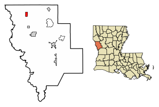
Converse is a village in Sabine Parish, Louisiana, United States. The population was 440 at the 2010 census.

<span class="mw-page-title-main">Many, Louisiana</span> Town in Louisiana, United States

Many is a town in, and the parish seat of Sabine Parish in western Louisiana, United States. The population was 2,853 at the 2010 census, a decrease of 36 or 1.246 percent from 2000.

<span class="mw-page-title-main">Anacoco, Louisiana</span> Village in Louisiana, United States

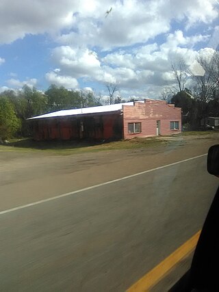
Anacoco is a village in Vernon Parish, Louisiana, United States. The population was 869 at the 2010 census. It is part of the Fort Johnson South Micropolitan Statistical Area.

<span class="mw-page-title-main">Simpson, Louisiana</span> Village in Louisiana, United States

Simpson is a village in Vernon Parish, Louisiana, United States. The population was 638 at the 2010 census. It is part of the Fort Johnson South Micropolitan Statistical Area.

<span class="mw-page-title-main">Allagash, Maine</span> Town in the state of Maine, United States

Allagash is a town in Aroostook County, Maine, United States. It is on the Allagash River in the North Maine Woods region.

<span class="mw-page-title-main">Mayville, Michigan</span> Village in Michigan, United States

Mayville is a village in Tuscola County, in the U.S. state of Michigan. The population was 948 at the 2010 census. The village is within Fremont Township along the boundary with Dayton Township.

<span class="mw-page-title-main">Lynch, Nebraska</span> Village in Nebraska, United States

Lynch is a village in Boyd County, Nebraska, United States. The population was 194 at the 2020 census, down from 245 in 2010. Lynch is located in northern Nebraska, between the Missouri and Niobrara rivers.

<span class="mw-page-title-main">Merriman, Nebraska</span> Village in Nebraska, United States

Merriman is a village in Cherry County, Nebraska. The population was 128 at the time of the 2010 census.

<span class="mw-page-title-main">Beech Bottom, West Virginia</span> Village in West Virginia, United States

Beech Bottom is a village in Brooke County, West Virginia, United States, situated along the Ohio River. The population was 523 at the 2010 census. It is part of the Weirton–Steubenville metropolitan area.

<span class="mw-page-title-main">Lowell, Wisconsin</span> Village in Wisconsin, United States

Lowell is a village in Dodge County, Wisconsin, United States, along the Beaver Dam River. The population was 340 at the 2010 census. The village is located within the Town of Lowell.

<span class="mw-page-title-main">Fairchild, Wisconsin</span> Village in Wisconsin, United States

Fairchild is a village in Eau Claire County, Wisconsin, United States. The population was 550 at the 2010 census. The village is located within the Town of Fairchild.

References

  1. "2020 U.S. Gazetteer Files". United States Census Bureau. Retrieved March 20, 2022.
  2. "Census of Population and Housing". Census.gov. Retrieved June 4, 2015.
  3. "Explore Census Data". data.census.gov. Retrieved December 29, 2021.
  4. "U.S. Census website". United States Census Bureau. Retrieved July 15, 2011.
  5. "U.S. Census website". United States Census Bureau . Retrieved January 31, 2008.
  6. "US Gazetteer files: 2010, 2000, and 1990". United States Census Bureau. February 12, 2011. Retrieved April 23, 2011.
  7. Climate Summary for closest city on record
  8. "Weatherbase.com". Weatherbase. 2013. Retrieved on May 8, 2013.