Ala Wai Canal

Last updated
Ala Wai Canal
AlaWai2.jpg
Ala Wai Canal
Coordinates 21°17′14″N157°49′52″W / 21.28722°N 157.83111°W / 21.28722; -157.83111
Specifications
Length1.5 miles (2.4 km)
StatusOpen
History
Construction began1921
Date completed1928
Geography
Start pointManoa and Palolo Streams (tributary)
End point Ala Wai Harbor, Pacific Ocean

The Ala Wai Canal is an artificial waterway in Honolulu, Hawaii which serves as the northern boundary of the tourist district of Waikiki. It was created in 1928 to drain the rice paddies and swamps which would eventually become Waikiki. It also serves as a primary drainage corridor for the rivers and streams that run through central and east Honolulu.

Contents

The canal runs from just northwest of Kapahulu Avenue along the length of Waikiki, then turns southwest to empty into the Pacific Ocean. Bridges cross the canal at McCully Street, Kalākaua Avenue, and Ala Moana Boulevard. Ala Wai Boulevard runs parallel to the west side of the canal in Waikiki.

History

Kalakaua Avenue bridge over the Ala Wai AlaWai3.jpg
Kalakaua Avenue bridge over the Ala Wai

Before the canal existed, Waikiki consisted of wetlands which were fed by streams running from the Makiki, Palolo, and Manoa valleys to the sea. In the early 1900s, Lucius Pinkham, then President of the Territorial Board of Health, proposed to construct a drainage canal to drain the wetlands, which he considered "unsanitary." Although the canal proposal was approved by the Board of Health, final approval did not occur until Pinkham became Governor of Hawaii.

Construction of the canal by Walter F. Dillingham's Hawaiian Dredging Construction Company, began in 1921 and was completed in 1928. When the city was issuing permits for new buildings in Waikiki they required builders to build above sea level. Dillingham sold the spoil he had dredged in creating the canal so builders could increase the elevation of the newly-created land. The canal is routinely dredged to this day.

The creation of the canal shunted the flow of the streams directly into the ocean, which resulted in the creation of several square miles of new real estate. Among those who benefited from the development were people who, though of modest means, had obtained and maintained small rice and bean farms. The reclamation of these lands were considered pivotal in the eventual development of Waikiki as a tourist center. [1]

As originally designed, the canal's two-mile long waterway had two outlets, one on either end, which allowed sediment to be flushed into the ocean. Engineers decided not to build the eastern outlet, near Kapiolani Park and the Waikiki Natatorium when they determined that contamination from that end would be deposited on the beach at Waikiki. [2] [3]

Major concerns

The bank of the Ala Wai Ala Wai Canal Honolulu.jpg
The bank of the Ala Wai

Federal flood experts have claimed heavy rain could cause the canal to overflow, potentially inundating the area from Diamond Head to Ala Moana and Moiliili with up to five feet of water. To prevent such a disaster, the U.S. Army Corps of Engineers has examined various measures, including digging a deeper channel, widening the McCully bridge, and adding walls along the canal. [2]

Another major issue is the pollution in the canal brought about by urbanization. In addition to runoff from streets and growing neighborhoods, mercury was detected in the canal. The mercury was attributed to the boat paint used in the Ala Wai Harbor. A 1976 Department of Health report also said that canal water regularly violated federal limits on fecal coliform counts, an indicator of high bacteria levels. [2]

The canal has been dredged at least three times, in 1967, 1978 and 2002. Most of the dredged sediment was deposited in the ocean, except for some sediment from the 2002 dredging, which was deemed too toxic and instead used for landfill at Honolulu International Airport. [2]

In March 2006, heavy thunderstorms and rains overwhelmed the sewers around the Ala Wai Canal, causing a pressurized sewage line to break. Days later, and after the spill was made public, then Mayor Mufi Hannemann decided to divert nearly 48 million US gallons (180,000 m3) of untreated sewage into the Ala Wai Canal in an attempt to avoid having the sewage back up into hotels and residences. This diversion caused partial overflowing of the canal in some areas, and the sewage then tainted Waikiki and nearby beaches. The beaches near the Ala Wai Canal, including beaches in the Waikiki and Ala Moana districts were closed temporarily due to health concerns. In the weeks after the incident, beaches were eventually reopened, but it took several months before the Ala Wai Canal was determined to be safe and free from major health concerns. [4] One person died from septic shock after falling into the Ala Wai Harbor near the mouth of the canal, with his death being attributed by some to the higher levels of bacteria present after the flood. [5]

Despite the canal repeatedly falling short of meeting safety standards for paddling and recreational use, there has been no move to prohibit such use. Hundreds of paddlers and boaters make it one of the most used inland waterways in the state. [2]

In 2022, researchers from the Department of Oceanography, University of Hawai‘i at Mānoa, published a paper [6] detailing the toxic levels of flesh-eating bacteria in the canal. Additionally, with the current worldwide environmental changes, the scientists' work, "suggest a 2- to 3-fold increase in average V. vulnificus density in the Ala Wai Canal by 2100".

Photos

Ala Wai Boulevard.jpg
Panoramic view of the Ala Wai Canal
View of the Ala Wai Canal from the 29th Floor Ala Wai Canal from the 29th Floor.jpg
View of the Ala Wai Canal from the 29th Floor

See also

Related Research Articles

<span class="mw-page-title-main">Honolulu</span> Capital and the largest city of Hawaii

Honolulu is the capital and most populous city of the U.S. state of Hawaii, which is in the Pacific Ocean. It is the unincorporated county seat of the consolidated City and County of Honolulu, situated along the southeast coast of the island of Oʻahu, and is the westernmost and southernmost major U.S. city. Honolulu is Hawaii's main gateway to the world. It is also a major hub for business, finance, hospitality, and military defense in both the state and Oceania. The city is characterized by a mix of various Asian, Western, and Pacific cultures, reflected in its diverse demography, cuisine, and traditions.

<span class="mw-page-title-main">Waikiki</span> Neighborhood of Honolulu in Honolulu County, Hawaii, United States

Waikiki is a Honolulu neighborhood and its eponymous beach on the south shore of the island of Oʻahu in the U.S. state of Hawaii.

<span class="mw-page-title-main">Ala Moana Center</span> Shopping mall in Honolulu, Hawaii, US

The Ala Moana Center, commonly known simply as Ala Moana, is a large open-air shopping mall in the Ala Moana neighborhood of Honolulu, Hawaii. Owned by Brookfield Properties, Ala Moana is the eighth largest shopping mall in the United States and the largest open-air shopping center in the world.

<span class="mw-page-title-main">Walter F. Dillingham</span>

Walter Francis Dillingham called the Baron of Hawaii Industry, was an industrialist and businessman from Honolulu, Hawaii. He gained favors from Hawaii politicians to develop urban Honolulu.

<span class="mw-page-title-main">Ala Moana Beach Park</span>

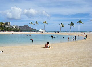
Ala Moana Beach Park is a free public park on the island of Oahu, U.S. state of Hawaii, located between Waikiki and downtown Honolulu. This 100-acre (0.40 km2) park has a wide gold-sand beach that is over a half-mile long.

<span class="mw-page-title-main">Kakaʻako</span> Neighborhood of Honolulu, Hawaii, United States

Kakaʻako is a commercial and retail district of Honolulu, Hawaiʻi between Ala Moana near Waikīkī to the east and downtown Honolulu and Honolulu Harbor to the west. Kakaʻako is situated along the southern shores of the island of Oʻahu, Hawaiʻi.

<span class="mw-page-title-main">Manoa</span> Neighborhood of Honolulu, Hawaii, US

Manoa is a valley and a residential neighborhood of Honolulu, Hawaiʻi. The neighborhood is approximately three miles east and inland from downtown Honolulu and less than a mile from Ala Moana and Waikiki.

<span class="mw-page-title-main">Lucius E. Pinkham</span> Fourth Territorial Governor of Hawaii (1850–1922)

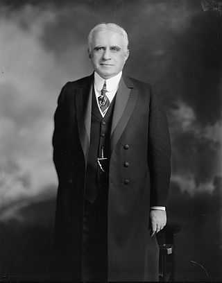
Lucius Eugene Pinkham was the fourth Territorial Governor of Hawaii, serving from 1913 to 1918. Pinkham was the first member of the Democratic Party of Hawaii to become governor.

<span class="mw-page-title-main">Charles J. McCarthy</span> American politician

Charles James McCarthy was the fifth Territorial Governor of Hawaii and served from 1918 to 1921.

<span class="mw-page-title-main">Ala Moana, Honolulu</span> Neighborhood of Honolulu, Hawaii, US

Ala Moana is a commercial, retail, and residential district of Honolulu, Hawaii. It is located between Waikiki and Moiliili to the east, and Kakaʻako and Honolulu Harbor to the west. King Street, to the north, marks the border with the neighborhood of Makiki.

<span class="mw-page-title-main">Kewalo Basin</span>

Kewalo Basin is a commercial boat harbor that serves as home to some of Honolulu's commercial fishing fleet, and charter and excursion vessels that serve the Hawaii tourist market. Pre-European contact, the area was historically used for human sacrifice. The land was given to Ihu by Kamehameha I and inherited by his daughter Kamakeʻe and her husband Jonah Piikoi. On the ocean side of the harbor is a small beach park on the Honolulu waterfront, located adjacent to the larger Ala Moana Beach Park. This park is good for swimming, picnicking and sightseeing. It can be accessed from the corners of Ala Moana Boulevard and Ward Avenue.

<span class="mw-page-title-main">Palolo, Hawaii</span> Neighborhood in Honolulu, Hawaii, United States

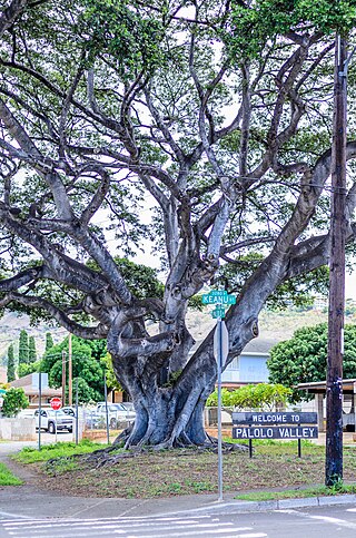
Pālolo is the name of a valley, stream, and residential neighborhood in Honolulu, Hawaii, the United States. The area lies approximately four miles east and inland from downtown Honolulu, less than a mile from Diamond Head. Like many of Hawaii's neighborhoods, Pālolo consists of an entire valley. The mauka (mountain-side) of the valley is agricultural in nature. The makai (ocean-side) of the valley ends approximately at Waiʻalae Avenue and is densely settled, mostly with single-family homes.

<span class="mw-page-title-main">Hawaii Route 92</span> Highway in Hawaii

Route 92 is a major east–west highway on the island of Oahu which begins at exit 15 off Interstate H-1 (H-1) in Honolulu. The western end of the highway is located at the gate to Joint Base Pearl Harbor–Hickam and the eastern end is 0.6 miles (0.97 km) east of the Ala Wai Canal crossing in Waikiki. The western portion of the highway, west of Richards Street, is named the Nimitz Highway. East of Richards Street, Route 92 is also known as Ala Moana Boulevard.

<span class="mw-page-title-main">Ala Moana Hotel</span> Hotel in Honolulu, Hawaii

The Ala Moana Hotel is a hotel in Honolulu, Hawaii, opened in 1970. It adjoins the Ala Moana Shopping Center and is across the street from the Hawaii Convention Center as well as the Ala Moana Beach Park.

<span class="mw-page-title-main">Kakaako Pumping Station</span> United States historic place

The Kakaʻako Pumping Station in Honolulu, Hawaii was designed by architect Oliver G. Traphagen in the Richardsonian Romanesque style. He also designed many such bold stone public works buildings in Duluth, Minnesota.

<span class="mw-page-title-main">Duke Paoa Kahanamoku Lagoon</span> Man-made wading pool in Waikiki, Honolulu, United States

Duke Paoa Kahanamoku Lagoon is a small, man-made wading pool in the Waikiki neighborhood of Honolulu, on the south shore of the island of Oʻahu near the Ala Wai Small Boat Harbor and Fort DeRussy Military Reservation. The Hilton Hawaiian Village is adjacent to the lagoon.

<span class="mw-page-title-main">Ala Wai Harbor</span> Small boat and yacht harbor in Hawaii

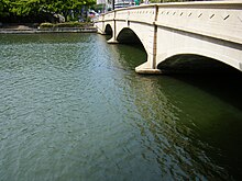
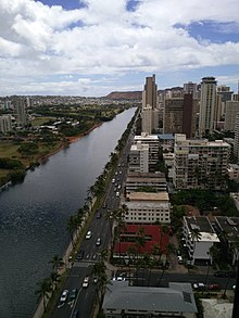
Ala Wai Harbor is the largest small boat and yacht harbor in Hawaii. The harbor is situated in Honolulu at the mouth of the Ala Wai Canal, between Waikiki and downtown Honolulu. To the east are Waikiki and Diamond Head; to the west, Magic Island and the Honolulu waterfront.

Donald Houston Graham Jr. was an American real estate developer and businessman credited with transforming the urban landscape of Hawaii by building condos, resorts, hotel, residences and shopping centers. He developed and constructed the Ala Moana Center in Ala Moana, which opened in 1959 and remains the largest outdoor shopping mall in the United States.

Ala Wai may refer to:

<span class="mw-page-title-main">Kalākaua Avenue</span>

Kalākaua Avenue is a street in Honolulu in the US federal state of Hawaii. The street travels across the tourist Centre of Waikīkī and belongs to the prospering streets of the United States. It demonstrates an architectural fusion of Hawaiian, Gothic, Asian, Spanish and Moorish architecture.

References

  1. "History and Heritage". Wiliki O Hawaii. American Society of Civil Engineers. September 1995. Archived from the original on 2011-05-10. Retrieved 2011-01-18.
  2. 1 2 3 4 5 Cocke, Sophie (2013-05-20). "Ala Wai Canal: Hawaii's Biggest Mistake?". Civil Beat. Retrieved 2013-05-20.
  3. Sigall, Bob (2011-04-22). "Ala Wai a polluted engineering marvel". The Honolulu Star-Advertiser. Retrieved 2013-05-20.
  4. Leone, Diana (March 31, 2006). "48 million US gallons (180,000 m3) spill in 6-day sewer break". The Honolulu Star-Bulletin. Retrieved 2011-01-18.
  5. Antone, Rod (April 30, 2006). "Tracing Oliver Johnson's final hours". The Honolulu Star-Bulletin. Retrieved 2011-01-18.
  6. Bullington, Jessica A.; Golder, Abigail R.; Steward, Grieg F.; McManus, Margaret A.; Neuheimer, Anna B.; Glazer, Brian T.; Nigro, Olivia D.; Nelson, Craig E. (2022). "Refining real-time predictions of Vibrio vulnificus concentrations in a tropical urban estuary by incorporating dissolved organic matter dynamics". Science of the Total Environment. 829: 154075. Bibcode:2022ScTEn.829o4075B. doi: 10.1016/j.scitotenv.2022.154075 . PMID   35218838. S2CID   247115891.