Alamo, Indiana

Last updated

Alamo, Indiana
Alamo-1.jpg
Location map of Montgomery County, Indiana.svg
Red pog.svg
Alamo
Location in Montgomery County
Coordinates: 39°59′00″N87°03′19″W / 39.98333°N 87.05528°W / 39.98333; -87.05528
Country United States
State Indiana
County Montgomery
Township Ripley
Area
[1]
  Total0.06 sq mi (0.16 km2)
  Land0.06 sq mi (0.16 km2)
  Water0.00 sq mi (0.00 km2)
Elevation
[2]
814 ft (248 m)
Population
 (2020) [3]
  Total66
  Density1,064.52/sq mi (409.27/km2)
Time zone UTC−5 (Eastern (EST))
  Summer (DST) UTC−5 (EST)
ZIP code
47916
Area code 765
FIPS code 18-00784
GNIS ID2397421 [2]

Alamo is a town in Ripley Township, Montgomery County, in the U.S. state of Indiana. [2] The population was 66 at the 2020 census, unchanged from 2010. [3]

Contents

History

Alamo was laid out and platted in 1837. [4] It became a small trading center for nearby farms. In 1859 a road connected Alamo to Crawfordsville, and the Yountsville Covered Bridge was built. [5] The town was named for the Alamo Mission in San Antonio, Texas. [6]

Gym in Alamo Alamo-gym.jpg
Gym in Alamo

The post office at Alamo has been in operation since 1844. [7]

Geography

Alamo is located in western Montgomery County 13 miles (21 km) southwest of Crawfordsville, the county seat.

According to the U.S. Census Bureau, Alamo has a total area of 0.06 square miles (0.16 km2), all land. [1] It sits on high ground which drains east to tributaries of Sugar Creek and west to tributaries of Stillwater Creek, which joins Sugar Mill Creek at Wallace and is part of the Sugar Creek watershed, flowing west to the Wabash River north of Montezuma.

Demographics

Historical population
CensusPop.Note
1880 220
1890 27223.6%
1900 241−11.4%
1910 209−13.3%
1920 167−20.1%
1930 163−2.4%
1940 155−4.9%
1950 1635.2%
1960 144−11.7%
1970 1450.7%
1980 17822.8%
1990 112−37.1%
2000 13722.3%
2010 66−51.8%
2020 660.0%
U.S. Decennial Census [8]

2010 census

As of the 2010 Census, [9] there were 66 people, 26 households, and 17 families living in the town. The population density was 942.9 inhabitants per square mile (364.1/km2). There were 39 housing units at an average density of 557.1 per square mile (215.1/km2). The racial makeup of the town was 89.4% White, 3.0% Native American, 6.1% from other races, and 1.5% from two or more races. Hispanic or Latino of any race were 6.1% of the population.

There were 26 households, of which 30.8% had children under the age of 18 living with them, 42.3% were married couples living together, 15.4% had a female householder with no husband present, 7.7% had a male householder with no wife present, and 34.6% were non-families. 26.9% of all households were made up of individuals, and 19.2% had someone living alone who was 65 years of age or older. The average household size was 2.54 and the average family size was 3.00.

The median age in the town was 36.7 years. 24.2% of residents were under the age of 18; 13.6% were between the ages of 18 and 24; 30.3% were from 25 to 44; 21.1% were from 45 to 64; and 10.6% were 65 years of age or older. The gender makeup of the town was 45.5% male and 54.5% female.

2000 census

As of the 2000 Census, [10] there were 137 people, 46 households, and 32 families living in the town. The population density was 2,388.6 inhabitants per square mile (922.2/km2). There were 53 housing units at an average density of 924.0 per square mile (356.8/km2). The racial makeup of the town was 89.05% White, 1.46% African American, 0.73% Native American, 1.46% from other races, and 7.30% from two or more races. Hispanic or Latino of any race were 1.46% of the population.

There were 46 households, out of which 45.7% had children under the age of 18 living with them, 47.8% were married couples living together, 17.4% had a female householder with no husband present, and 28.3% were non-families. 28.3% of all households were made up of individuals, and 13.0% had someone living alone who was 65 years of age or older. The average household size was 2.98 and the average family size was 3.64.

In the town, the population was spread out, with 38.0% under the age of 18, 5.8% from 18 to 24, 28.5% from 25 to 44, 16.8% from 45 to 64, and 10.9% who were 65 years of age or older. The median age was 28 years. For every 100 females, there were 95.7 males. For every 100 females age 18 and over, there were 97.7 males.

The median income for a household in the town was $17,500, and the median income for a family was $19,583. Males had a median income of $32,813 versus $23,750 for females. The per capita income for the town was $8,800. There were 30.3% of families and 29.6% of the population living below the poverty line, including 42.6% of under eighteens and none of those over 64.

Education

South Montgomery Community School Corporation operates public schools serving Alamo. Southmont Junior High School and Southmont High School serve secondary students. [11]

Organizations

There are three main not-for-profit organizations in Alamo:

Related Research Articles

<span class="mw-page-title-main">Panama, Illinois</span> Village in Illinois, United States

Panama is a village in Montgomery and Bond counties, Illinois, United States. The population was 337 at the 2020 census.

<span class="mw-page-title-main">Grabill, Indiana</span> Town in Indiana, United States

Grabill is a town in Cedar Creek Township, Allen County, Indiana, United States. The population was 1,053 at the 2010 census. Today it is known for the presence of antique stores and Amish farms. An incorporated town, Grabill has two community parks within the corporate limits.

<span class="mw-page-title-main">Thorntown, Indiana</span> Town in Indiana, United States

Thorntown is a town in Sugar Creek Township, Boone County, Indiana. The population was 1,520 at the time of the 2010 census. Thorntown is located in northwestern Boone County, about halfway between Lafayette and Indianapolis.

<span class="mw-page-title-main">Owensville, Indiana</span> Town in Indiana, United States

Owensville is the third largest town and the smallest of the five larger communities in Gibson County, Indiana, United States. The population was 1,338 in 2020.

<span class="mw-page-title-main">Cumberland, Indiana</span> Town in Indiana, United States

Cumberland is a town in Hancock and Marion counties, Indiana, United States. The population was 5,954 at the 2020 census, up from 5,169 in 2010.

<span class="mw-page-title-main">Amboy, Indiana</span> Town in Indiana, United States

Amboy is a town in Jackson Township, Miami County, in the U.S. state of Indiana. The population was 317 at the 2020 census, down from 384 in 2010.

<span class="mw-page-title-main">Bunker Hill, Indiana</span> Town in Indiana, United States

Bunker Hill is a town in Pipe Creek Township, Miami County, in the U.S. state of Indiana. The population was 814 at the 2020 census, down from 888 in 2010.

<span class="mw-page-title-main">Denver, Indiana</span> Town in Indiana, United States

Denver is a town in Jefferson Township, Miami County, in the U.S. state of Indiana. The population was 478 at the 2020 census.

<span class="mw-page-title-main">Crawfordsville, Indiana</span> City in Indiana, United States

Crawfordsville is a city in Montgomery County in west central Indiana, United States, 49 miles (79 km) west by northwest of Indianapolis. As of the 2020 census, the city had a population of 16,306. The city is the county seat of Montgomery County, the only chartered city and the largest populated place in the county. It is the principal city of the Crawfordsville, IN Micropolitan Statistical Area, which encompasses all of Montgomery County. The city is also part of the Indianapolis–Carmel–Muncie, IN Combined Statistical Area.

<span class="mw-page-title-main">Darlington, Indiana</span> Town in Indiana, United States

Darlington is a town in Franklin Township, Montgomery County, in the U.S. state of Indiana. The population was 711 at the 2020 census, down from 843 in 2010.

<span class="mw-page-title-main">Ladoga, Indiana</span> Town in Indiana, United States

Ladoga is a town in Clark Township, Montgomery County, in the U.S. state of Indiana. The population was 1,081 at the 2020 census, up from 985 in 2010.

<span class="mw-page-title-main">Linden, Indiana</span> Town in Indiana, United States

Linden is a town in Madison Township, Montgomery County, in the U.S. state of Indiana. The population was 711 at the 2020 census.

<span class="mw-page-title-main">New Market, Indiana</span> Town in Indiana, United States

New Market is a town in Montgomery County, Indiana, in the United States. The population was 559 at the 2020 census, down from 636 in 2010.

New Richmond is a town in Coal Creek Township, Montgomery County, in the U.S. state of Indiana. The population was 309 at the 2020 census.

New Ross is a town in Walnut Township, Montgomery County, in the U.S. state of Indiana. As of the 2020 census, the town population was 309.

<span class="mw-page-title-main">Waveland, Indiana</span> Town in Indiana, United States

Waveland is a town in Brown Township, Montgomery County, in the U.S. state of Indiana. The population was 427 at the 2020 census.

<span class="mw-page-title-main">Waynetown, Indiana</span> Town in Indiana, United States

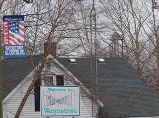
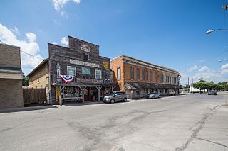
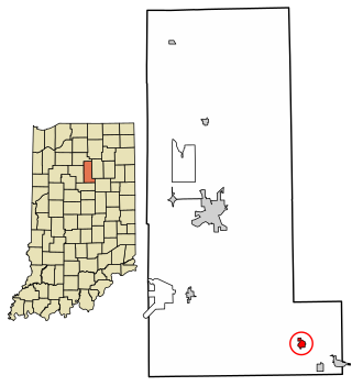
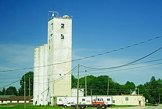
Waynetown is a town in Wayne Township, Montgomery County, in the U.S. state of Indiana. The population was 960 at the 2020 census.

<span class="mw-page-title-main">Mecca, Indiana</span> Town in Indiana, United States

Mecca is a town in Wabash Township, Parke County, in the U.S. state of Indiana. The population was 335 at the 2010 census.

<span class="mw-page-title-main">West Terre Haute, Indiana</span> Town in Indiana, United States

West Terre Haute is a town in Sugar Creek Township, Vigo County, Indiana, on the western side of the Wabash River near Terre Haute. The population was 2,236 at the 2010 census. It is part of the Terre Haute Metropolitan Statistical Area. Bethany Congregational Church was placed on the National Register of Historic Places in 2003.

<span class="mw-page-title-main">Williams Creek, Indiana</span> Town in Indiana, United States

Williams Creek is a town in Washington Township, Marion County, Indiana, United States. It is located about 9 miles (14 km) north of downtown Indianapolis. The population was 430 at the 2020 census. It has existed as an "included town" since 1970, when it was incorporated into Indianapolis as part of Unigov. It is part of Indianapolis, but retains a functioning town government under IC 36-3-1-11.

References

  1. 1 2 "2022 U.S. Gazetteer Files: Indiana". United States Census Bureau. Retrieved April 19, 2023.
  2. 1 2 3 U.S. Geological Survey Geographic Names Information System: Alamo, Indiana
  3. 1 2 "P1. Race – Alamo town, Indiana: 2020 DEC Redistricting Data (PL 94-171)". U.S. Census Bureau. Retrieved April 19, 2023.
  4. Beckwith, Hiram Williams; Kennedy, P. S. (1881). History of Montgomery County, Together with Historic Notes on the Wabash Valley. H. H. Hill and N. Iddings. p.  585.
  5. Gronert, Theodore G., Sugar Creek Saga: A History and Development of Montgomery County, Wabash College, 1958. Pg 51-53
  6. Baker, Ronald L. (October 1995). From Needmore to Prosperity: Hoosier Place Names in Folklore and History . Indiana University Press. p.  47. ISBN   978-0-253-32866-3. The name comes from the fort in San Antonio, Texas.
  7. "Montgomery County". Jim Forte Postal History. Retrieved June 10, 2017.
  8. "Census of Population and Housing". Census.gov. Retrieved June 4, 2015.
  9. "U.S. Census website". United States Census Bureau . Retrieved December 11, 2012.
  10. "U.S. Census website". United States Census Bureau . Retrieved January 31, 2008.
  11. "SCHOOL DISTRICT REFERENCE MAP (2010 CENSUS): Montgomery County, IN." U.S. Census Bureau. Retrieved on November 26, 2016.