
Pierce County is a county in the U.S. state of Washington. As of the 2020 census, the population was 921,130, up from 795,225 in 2010, making it the second-most populous county in Washington, behind King County, and the 60th-most populous in the United States. The county seat and largest city is Tacoma. Formed out of Thurston County on December 22, 1852, by the legislature of Oregon Territory, it was named for U.S. President Franklin Pierce. Pierce County is in the Seattle metropolitan area.

Fife is a city in Pierce County, Washington, United States and a suburb of Tacoma. The population was 10,999 at the 2020 census. Fife is contained within the Puyallup Indian Reservation.

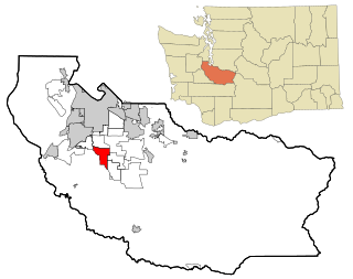
Frederickson is a census-designated place (CDP) in Pierce County, Washington, United States. The population was 24,906 at the 2020 census.

Midland is a census-designated place (CDP) in Pierce County, Washington. The population was 7,414 at the time of the 2000 census.

Orting is a city in Pierce County, Washington, United States. The population was 9,041 at the 2020 census.

Puyallup is a city in Pierce County, Washington, United States, located about 10 miles southeast of Tacoma and 35 miles south of Seattle. It had a population of 42,973 at the 2020 census. The city's name comes from the Puyallup Tribe of Native Americans and means "the generous people". Puyallup is also home to the Washington State Fair, the state's largest fair.
Spanaway is a census-designated place (CDP) in Pierce County, Washington, United States. The population was 35,476 at the 2020 census, up from 27,227 in 2010. Spanaway is an unincorporated area near Tacoma, and is often identified together with the more urban, less wealthy Parkland.

Sumner is a city in northern Pierce County, Washington, United States. The population was 10,621 at the 2020 census. Nearby cities include Puyallup to the west, Auburn to the north, and Bonney Lake to the east.
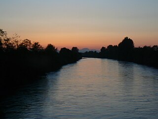
The Puyallup River is a river in the U.S. state of Washington. About 45 miles (72 km) long, it is formed by glaciers on the west side of Mount Rainier. It flows generally northwest, emptying into Commencement Bay, part of Puget Sound. The river and its tributaries drain an area of about 948 square miles (2,460 km2) in Pierce County and southern King County.

State Route 410 is a 107.44-mile (172.91 km) long state highway that traverses Pierce, King, and Yakima counties in the US state of Washington. It begins at an interchange with SR 167 in Sumner and travels southeast across the Cascade Range to a junction with U.S. Route 12 (US 12) in Naches. While the western part of SR 410 is a freeway that serves built-up, urban areas, the remainder of the route is a surface road that traverses mostly rural areas as it passes through the mountains.
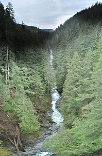
The Carbon River is a river in the U.S. state of Washington. It flows about 30 miles (48 km) from its source, the Carbon Glacier on Mount Rainier, to join the Puyallup River at Orting.
Naches Pass is a mountain pass in the Cascade Range in the state of Washington. It is located about 50 miles (80 km) east of Tacoma and about 50 miles (80 km) northwest of Yakima, near the headwaters of tributary streams of the Naches River on the east and the Greenwater River on the west. The boundaries of Pierce, King, Kittitas, and Yakima counties come together at the pass. The pass lies on the boundary between the Mount Baker-Snoqualmie and Wenatchee National Forests, about 10 miles (16 km) northeast of Mount Rainier National Park. There are no roadways or railways crossing the pass.

Tehaleh, formerly known as Cascadia, is a master-planned unincorporated community to the south of Bonney Lake in Pierce County, Washington, United States. Construction began in 2005 with an estimated timeline for completion of 20 years. The town was designed by Patrick Kuo, who had purchased the land in 1991. Included in the original plan for Cascadia were 6,500 homes, a commercial district, an industrial park, schools, and recreational parkland for residents to enjoy. Construction halted in 2008, prior to the construction of any homes or commercial properties. After foreclosure proceedings in 2010, Homestreet Bank repossessed much of Kuo's land, intending to find another developer.
The Foothills Trail is a mostly paved non-motorized rail-trail in east Pierce County, Washington, extending uninterrupted for 21 miles (34 km) from Puyallup, Washington to Orting, Washington to South Prairie, Washington to Buckley, Washington. The trail is used by cyclists, walkers, joggers, inline skaters, and horse riders. Listed as Foothills Regional Trail, it was designated a National Recreation Trail in 2012.
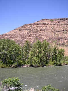
The Naches River is a tributary of the Yakima River in central Washington in the United States. Beginning as the Little Naches River, it is about 75 miles (121 km) long. After the confluence of the Little Naches and Bumping River the name becomes simply the Naches River. The Naches and its tributaries drain a portion of the eastern side of the Cascade Range, east of Mount Rainier and northeast of Mount Adams. In terms of discharge, the Naches River is the largest tributary of the Yakima River.

State Route 162 (SR 162) is a 17.37-mile-long (27.95 km) state highway in the U.S. state of Washington, serving rural Pierce County. The highway travels from an interchange with SR 410 in Sumner and travels south along the Puyallup River to Orting and northeast to South Prairie, ending at an intersection with SR 165 near Buckley. SR 162 was established in 1964 as the successor to Secondary State Highway 5E (SSH 5E), which was codified in 1937. The highway crossed the Puyallup River northwest of Orting on the McMillin Bridge, which opened in 1934 and was replaced with a newer bridge that opened in 2015.

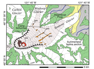
Mount Rainier, also known as Tahoma, Tacoma, Tacobet, or təqʷubəʔ, is a large active stratovolcano in the Cascade Range of the Pacific Northwest, located in Mount Rainier National Park about 59 miles (95 km) south-southeast of Seattle. With a summit elevation of 14,411 ft (4,392 m), it is the highest mountain in the U.S. state of Washington and the Cascade Range, the most topographically prominent mountain in the contiguous United States, and the tallest in the Cascade Volcanic Arc.
The Mount Rainier Volcano Lahar Warning System consists of two separate components, operating in tandem: Acoustic Flow Monitors (AFM) and the All Hazard Alert Broadcast (AHAB) sirens. The AFM system was developed by the United States Geological Survey (USGS) in 1998 and is now maintained by Pierce County Emergency Management. The purpose of the warning system is to assist in the evacuation of residents in the river valleys around Mount Rainier, a volcano in Washington, in the event of a lahar. Pierce County works in partnership with the USGS, the Pacific Northwest Seismic Network (PNSN), Washington Military Department's Emergency Management Division, and South Sound 9-1-1 to monitor and operate the system.
The Bridge for Kids is a proposed bridge across the Carbon River in Orting, Washington, about a mile upstream of where it joins the Puyallup River. It would provide an emergency evacuation route for school children to escape a future lahar flow from Mount Rainier, consisting of an up to 10-meter (33 ft) high flood of mud, rock and boulders. As of 2016, the $40 million bridge was still in the planning phase.
The Osceola Mudflow, also known as the Osceola Lahar, was a lahar in the U.S. state of Washington that descended from the summit and northeast slope of Mount Rainier during a period of eruptions about 5,600 years ago. It traveled down the west and main forks of the White River, passed the location of present-day Enumclaw then reached Puget Sound near present-day Auburn. The Osceola collapse formed a 1.8 km (1.1 mi) wide horseshoe-shaped crater, open to the northeast, almost the same size as the crater produced by the 1980 eruption of Mount St. Helens. Most of the Osceola crater has been filled in by subsequent lava eruptions, most recently about 2,200 years ago.


