
The Lower Colorado River Authority (LCRA) is a nonprofit public utility created in November 1934 by the Texas Legislature. LCRA's mission is to enhance the lives of the Texans it serves through water stewardship, energy and community service. LCRA provides public power, manages the lower Colorado River, builds and operates transmission lines, owns public parks, and offers community services.

Priest Rapids Dam is a hydroelectric, concrete gravity dam; located on the Columbia River, between the Yakima Firing Range and the Hanford Nuclear Reservation, and bridges Yakima County and Grant County, in the U.S. state of Washington. The dam is 24 miles south of the town of Vantage, and 47 miles northwest of the city of Richland. It is located at mile marker 397.1 from the mouth of the Columbia. It is owned by the Grant County Public Utility District (PUD). Priest Rapids, for which the dam was named, are now submerged beneath the dam's reservoir.

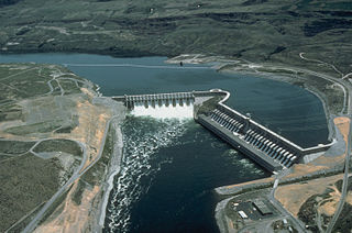
Grand Coulee Dam is a concrete gravity dam on the Columbia River in the U.S. state of Washington, built to produce hydroelectric power and provide irrigation water. Constructed between 1933 and 1942, Grand Coulee originally had two powerhouses. The third powerhouse ("Nat"), completed in 1974 to increase energy production, makes Grand Coulee the largest power station in the United States by nameplate-capacity at 6,809 MW.

The Nisqually River is a river in west central Washington in the United States, approximately 81 miles (130 km) long. It drains part of the Cascade Range southeast of Tacoma, including the southern slope of Mount Rainier, and empties into the southern end of Puget Sound. Its outlet was designated in 1971 as the Nisqually Delta National Natural Landmark.
Puget Sound Energy (PSE) is an energy utility company based in the U.S. state of Washington that provides electrical power and natural gas to the Puget Sound region. The utility serves electricity to more than 1.1 million customers in Island, King, Kitsap, Kittitas, Pierce, Skagit, Thurston, and Whatcom counties, and provides natural gas to 750,000 customers in King, Kittitas, Lewis, Pierce, Snohomish and Thurston counties. The company's electric and natural gas service area spans 6,000 square miles (16,000 km2).

This is a list of properties and historic districts in Washington that are listed on the National Register of Historic Places. There are at least three listings in each of Washington's 39 counties.

Childs-Irving Hydroelectric Facilities consisted of two 20th-century power plants, a dam, and related infrastructure along or near Fossil Creek in the U.S. state of Arizona. The complex was named an Historic Mechanical Engineering Landmark in 1971 and was added to the National Register of Historic Places 20 years later. Decommissioned in 2005, the plants no longer produce electricity, and much of the infrastructure—including the dam, the Irving Power Plant, and thousands of feet of concrete flumes—have been removed, and the creek's original flow has been restored.
Run-of-river hydroelectricity (ROR) or run-of-the-river hydroelectricity is a type of hydroelectric generation plant whereby little or no water storage is provided. Run-of-the-river power plants may have no water storage at all or a limited amount of storage, in which case the storage reservoir is referred to as pondage. A plant without pondage is subject to seasonal river flows, thus the plant will operate as an intermittent energy source. Conventional hydro uses reservoirs, which regulate water for flood control, dispatchable electrical power, and the provision of fresh water for agriculture.

Croton Dam is an earth-filled embankment dam and powerplant complex on the Muskegon River in Croton Township, Newaygo County, Michigan. It was built in 1907 under the direction of William D. Fargo by the Grand Rapids - Muskegon Power Company, a predecessor of Consumers Energy. The 40-foot-high (12 m) dam impounds 7.2 billion U.S. gallons (6 billion imp. gal/27 billion L) of water in its 1,209-acre (489 ha) reservoir and is capable of producing 8,850 kilowatts at peak outflow. It was listed on the National Register of Historic Places in 1979.

Mossyrock Dam is a concrete arch-gravity dam on the Cowlitz River near Mossyrock in Lewis County, Washington. The reservoir created by the dam is called Riffe Lake and the primary purpose of the dam is hydroelectric production while flood control is secondary. The dam is the tallest in Washington State and its hydroelectric power station supplies 40% of Tacoma Power's electricity.

Wilbur Dam is a hydroelectric dam on the Watauga River in Carter County, in the U.S. state of Tennessee. It is one of two dams on the river owned and operated by the Tennessee Valley Authority. The dam impounds Wilbur Lake, which extends for about 3 miles (4.8 km) up the Watauga to the base of Watauga Dam. Wilbur Dam was completed in 1912 making it the second oldest dam in the TVA system behind Ocoee Dam No. 1. Wilbur Dam was one of the first major hydroelectric projects in Tennessee, and remains one of the oldest dams in the TVA system.
Dul Hasti is a 390 MW hydroelectric power plant in Kishtwar district of Jammu and Kashmir, India built by NHPC. The power plant is a run-of-the-river type on the Chenab River, in the Kishtwar region, a rugged, mountainous section of the Himalayas, and several hundred kilometers from larger cities. It consists of a 70 m (230 ft) tall gravity dam which diverts water through a 9.5 km (5.9 mi) long headrace tunnel to the power station which discharges back into the Chenab. The project provides peaking power to the Northern Grid with beneficiary states being Jammu and Kashmir, Punjab, Haryana, Uttar Pradesh, Uttarakhand, Rajasthan, Delhi and Union Territory of Chandigarh. It was constructed between 1985 and 2007.

Long Lake Dam is a concrete gravity dam on the Spokane River, between Lincoln County and Stevens County about 30 miles (48 km) northwest of Spokane in eastern Washington. It forms Long Lake (Washington), a 23.5 mi (37.8 km) long reservoir, and has a hydroelectric generating capacity of 71 megawatts. The dam was built by Washington Water Power, which operates five other dams along the Spokane.

The Saguling Dam is an embankment dam on the headwater of Citarum River in West Java, Indonesia. It is located 26 km (16 mi) west of Bandung. Construction began in 1983. The reservoir had filled by 1985 and the first generator was operational in 1986. The primary purpose of the dam is hydroelectric power generation but it also provides for water supply and aquaculture. The 99 m (325 ft) tall dam is rock-fill embankment-type with watertight core that withholds a reservoir with a capacity of 2,750,000,000 m3 (2,229,461 acre⋅ft). Its power station has 4 x 175 MW Francis turbine generators with an installed capacity of 700 MW. Including land acquisition, the cost of the dam with power plant was about $US 663 million. The installed capacity of the power plant might be expanded to 1,400 MW in the future. The construction of the dam resulted in displacement of nearly 60,000 people.

Abiquiu Dam is a dam on the Rio Chama, located about 60 miles (97 km) northwest of Santa Fe in Rio Arriba County, New Mexico. Built and operated by the U.S. Army Corps of Engineers (USACE), the dam is an earth embankment structure 354 feet (108 m) high and 1,800 feet (550 m) long, containing 11.8 million cubic yards of fill. The dam forms Abiquiu Lake, one of the largest lakes in New Mexico with a full storage capacity of 1,369,000 acre-feet (1,689,000 dam3) and 5,200 acres (2,100 ha) of water. To date, the reservoir has never filled to capacity, with a record high of 402,258 acre-feet (496,178 dam3), 29.4% of full pool, on June 22, 1987. The dam's primary purpose is flood control, in addition to irrigation and municipal water storage, and hydroelectric generation.

The Electron Hydroelectric Project, originally known as the Puyallup Project, is a hydroelectric power plant operated by Electron Hydro LLC on the Puyallup River in Pierce County, Washington. It generates 22 megawatts (30,000 hp) of electricity and is operated and maintained by approximately 20 full-time employees.

Electricity in the Puget Sound region is a significant factor in people's lives, an enabler for the modern economy, and has a unique relationship with the region's environment.
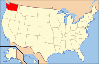
The following outline is provided as an overview of and topical guide to infrastructure of the U.S. state of Washington.

