Alfonso Castañeda

Last updated

Alfonso Castañeda
Municipality of Alfonso Castañeda
AlfonsoCastaneda,Cabanatuanjf9950 05.JPG
Downtown area
Flag of Alfonso Castaneda, Nueva Vizcaya.png
Nickname: 
Last Frontier of Nueva Vizcaya
Ph locator nueva vizcaya alfonso castaneda.png
Map of Nueva Vizcaya with Alfonso Castañeda highlighted
OpenStreetMap
Alfonso Castaneda
Philippines location map (square).svg
Red pog.svg
Alfonso Castañeda
Location within the Philippines
Coordinates: 15°47′36″N121°18′09″E / 15.7933°N 121.3025°E / 15.7933; 121.3025
Country Philippines
Region Cagayan Valley
Province Nueva Vizcaya
District Lone district
Barangays 6 (see Barangays)
Government
[1]
  Type Sangguniang Bayan
   Mayor Wilson M. Capia-ao
   Vice Mayor Evelinda D. Huerta
   Representative Luisa L. Cuaresma
   Electorate 6,141 voters (2022)
Area
[2]
  Total375.40 km2 (144.94 sq mi)
Elevation
430 m (1,410 ft)
Highest elevation
1,079 m (3,540 ft)
Lowest elevation
169 m (554 ft)
Population
 (2020 census) [3]
  Total8,539
  Density23/km2 (59/sq mi)
   Households
1,795
Economy
   Income class 1st municipal income class
   Poverty incidence
22.92
% (2018) [4]
   Revenue 134.3 million (2020)
   Assets 422.4 million (2020)
   Expenditure 157.5 million (2020)
   Liabilities 111.9 million (2020)
Service provider
  ElectricityNueva Vizcaya Electric Cooperative (NUVELCO)
Time zone UTC+8 (PST)
ZIP code
3714
PSGC
IDD : area code +63(0)78
Native languages Ilocano
Tagalog
Website https://acasnv.gov.ph

Alfonso Castañeda, officially the Municipality of Alfonso Castañeda (Ilocano : Ili ti Alfonso Castañeda; Tagalog : Bayan ng Alfonso Castañeda), is a 1st class municipality in the province of Nueva Vizcaya, Philippines. According to the 2020 census, it has a population of 8,539 people, making it the least populated municipality in the province. [3]

Contents

Alfonso Castañeda is 206 kilometers (128 mi) from Bayombong via Nueva Ecija and Dalton Pass and 192 kilometers (119 mi) from Manila.

History

The territory now comprising Alfonso Castañeda was part of the municipality of Dupax prior to the division into three separate ones; the other two were Dupax del Norte and Dupax del Sur. [5]

In the early 18th century, Dupax was inhabited by three tribes. [6] [5] One of them were the Bugkalots; the rest were the Malaats and the Caraos. [5]

In 1930, five families supposedly from Batac, Ilocos Norte settled in Lublub, an area inhabited by Bugkalots which was later organized as a sitio of barrio Marikit [7] when the inhabitants increased; Virgilio Castillo was the first teniente del barrio. [8] In 1950, it became an independent barrio in Pantabangan, Nueva Ecija. [7] In 1974, [8] residents headed by village chief Alfredo Castillo, Sr. requested Assemblyman Carlos Padilla to convert the barrio into a municipality in Nueva Vizcaya. [7] Hence, Batas Pambansa Blg. 27, authored and sponsored by Padilla, [7] was issued by President Ferdinand Marcos on April 20, 1979; two barangays , including Lublub which was designated the seat of government, and seven sitios in Dupax del Sur, and four barangays and a sitio in Dupax del Norte, were separated to constitute into an independent municipality named after the first provincial governor to come from a cultural minority. [9] [7] The plebiscite was held on July 10. [10] Castillo was appointed the municipality's first mayor. [8]

Geography

Barangays

Alfonso Castañeda is politically subdivided into 6 barangays. Each barangay consists of puroks and some have sitios.

  • Abuyo
  • Galintuja
  • Cawayan
  • Lipuga
  • Lublub (Poblacion)
  • Pelaway

Climate

Climate data for Alfonso Castañeda, Nueva Vizcaya
MonthJanFebMarAprMayJunJulAugSepOctNovDecYear
Mean daily maximum °C (°F)25
(77)
26
(79)
28
(82)
30
(86)
30
(86)
29
(84)
28
(82)
28
(82)
28
(82)
28
(82)
27
(81)
25
(77)
28
(82)
Mean daily minimum °C (°F)18
(64)
18
(64)
19
(66)
21
(70)
22
(72)
22
(72)
22
(72)
22
(72)
22
(72)
21
(70)
20
(68)
19
(66)
21
(69)
Average precipitation mm (inches)25
(1.0)
26
(1.0)
18
(0.7)
24
(0.9)
91
(3.6)
145
(5.7)
149
(5.9)
122
(4.8)
120
(4.7)
128
(5.0)
61
(2.4)
52
(2.0)
961
(37.7)
Average rainy days7.75.76.88.018.222.124.323.422.717.510.09.4175.8
Source: Meteoblue [11]

Demographics

Population census of Alfonso Castañeda
YearPop.±% p.a.
1980 2,797    
1990 3,751+2.98%
1995 4,447+3.24%
2000 4,808+1.69%
2007 6,655+4.59%
2010 7,428+4.08%
2015 7,940+1.28%
2020 8,539+1.44%
Source: Philippine Statistics Authority [12] [13] [14] [15]

Economy

Poverty Incidence of Alfonso Castañeda

10
20
30
40
2006
14.10
2009
13.97
2012
33.46
2015
19.72
2018
22.92
2021
15.14

Source: Philippine Statistics Authority [16] [17] [18] [19] [20] [21] [22] [23]

Tourism

Government

Local government

Town hall AlfonsoCastanedaTownHalljf9975 10.JPG
Town hall

Alfonso Castañeda, belonging to the lone congressional district of the province of Nueva Vizcaya, is governed by a mayor designated as its local chief executive and by a municipal council as its legislative body in accordance with the Local Government Code. The mayor, vice mayor, and the councilors are elected directly by the people through an election which is being held every three years.

Elected officials

Members of the Municipal Council
(2022–2025) [24]
PositionNameParty
MayorWilson M. Capia-ao Lakas
Vice MayorEvelinda D. Huerta Lakas
CouncilorsSonny Poncian Lakas
Jethro D. Castillo Independent
Gabreil Marcelo Independent
Rey Palecpec Lakas
Jao Valdez Nacionalista
Terence Camania Nacionalista
Bojie Batino Lakas
Zandro Castillo Lakas

Education

The Schools Division of Nueva Vizcaya governs the town's public education system. The division office is a field office of the DepEd in Cagayan Valley region. [25] The office governs the public and private elementary and public and private high schools throughout the municipality.

Related Research Articles

<span class="mw-page-title-main">Nueva Vizcaya</span> Province in Cagayan Valley, Philippines

Nueva Vizcaya, officially the Province of Nueva Vizcaya, is a landlocked province in the Philippines located in the Cagayan Valley region in Luzon. Its capital is Bayombong. It is bordered by Benguet to the west, Ifugao to the north, Isabela to the northeast, Quirino to the east, Aurora to the southeast, Nueva Ecija to the south, and Pangasinan to the southwest. Quirino province was created from Nueva Vizcaya in 1966.

<span class="mw-page-title-main">Bambang, Nueva Vizcaya</span> Municipality in the Philippines

Bambang, officially the Municipality of Bambang, is a 1st class municipality in the province of Nueva Vizcaya, Philippines. According to the 2020 censusus, it has a population of 55,789 people.

<span class="mw-page-title-main">Dupax del Norte</span> Municipality in Nueva Vizcaya, Philippines

Dupax del Norte, officially the Municipality of Dupax del Norte, is a 3rd class municipality in the province of Nueva Vizcaya, Philippines. According to the 2020 census, it has a population of 33,295 people. Dupax del Norte, situated on the south-eastern part of Nueva Vizcaya, has a total land area of 396 square kilometers. It is bounded by the town of Kasibu in the north, Alfonso Castañeda in the east, Dupax del Sur in the south, and Bambang in the west. It has wide tracts of virgin forests, rich, fertile plains and valleys with mineral deposits and has a climate suitable for agriculture.

<span class="mw-page-title-main">Bagabag, Nueva Vizcaya</span> Municipality in Nueva Vizcaya, Philippines

Bagabag, officially the Municipality of Bagabag, is a 2nd class municipality in the province of Nueva Vizcaya, Philippines. According to the 2020 census, it has a population of 37,985 people.

<span class="mw-page-title-main">Abulug</span> Municipality in Cagayan, Philippines

Abulug, officially the Municipality of Abulug, is a 3rd class municipality in the province of Cagayan, Philippines. According to the 2020 census, it has a population of 34,579 people.

<span class="mw-page-title-main">Gattaran</span> Municipality in Cagayan, Philippines

Gattaran, officially the Municipality of Gattaran, is a 1st class municipality in the province of Cagayan, Philippines. According to the 2020 census, it has a population of 58,874 people.

<span class="mw-page-title-main">Lasam</span> Municipality in Cagayan, Philippines

Lasam, officially the Municipality of Lasam, is a third class municipality in the province of Cagayan, Philippines. According to the 2020 census, it has a population of 41,225 people.

<span class="mw-page-title-main">Cordon, Isabela</span> Municipality in Isabela, Philippines

Cordon, officially the Municipality of Cordon, is a 2nd class municipality in the province of Isabela, Philippines. According to the 2020 census, it has a population of 46,477 people.

<span class="mw-page-title-main">Echague</span> Municipality in Isabela, Philippines

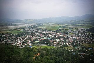
Echague, officially the Municipality of Echague, is a 1st class municipality in the province of Isabela, Philippines. According to the 2020 census, it has a population of 88,410 people. The town is known for the indigenous and endangered Yogad language, which is spoken and conserved by its locals.

<span class="mw-page-title-main">Santo Tomas, Isabela</span> Municipality in Isabela, Philippines

Santo Tomas, officially the Municipality of Santo Tomas, is a 4th class municipality in the province of Isabela, Philippines. According to the 2020 census, it has a population of 24,528 people.

<span class="mw-page-title-main">Ambaguio</span> Municipality in Nueva Vizcaya, Philippines

Ambaguio, officially the Municipality of Ambaguio, is a 5th class municipality in the province of Nueva Vizcaya, Philippines. According to the 2020 census, it has a population of 15,472 people.

<span class="mw-page-title-main">Dupax del Sur</span> Municipality in Nueva Vizcaya, Philippines

Dupax del Sur, officially the Municipality of Dupax del Sur, is a 2nd class municipality in the province of Nueva Vizcaya, Philippines. At the 2020 census, it had a population of 21,224 people.

<span class="mw-page-title-main">Kasibu</span> Municipality in Nueva Vizcaya, Philippines

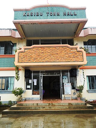
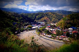
Kasibu, officially the Municipality of Kasibu, is a 3rd class municipality in the province of Nueva Vizcaya, Philippines. According to the 2020 census, it has a population of 41,776 people.

<span class="mw-page-title-main">Kayapa</span> Municipality in Nueva Vizcaya, Philippines

Kayapa, officially the Municipality of Kayapa, is a 3rd class municipality in the province of Nueva Vizcaya, Philippines. According to the 2020 census, it has a population of 26,469 people.

<span class="mw-page-title-main">Quezon, Nueva Vizcaya</span> Municipality in Nueva Vizcaya, Philippines

Quezon, officially the Municipality of Quezon, is a 4th class municipality in the province of Nueva Vizcaya, Philippines. According to the 2020 census, it has a population of 24,055 people.

<span class="mw-page-title-main">Solano, Nueva Vizcaya</span> Municipality in Nueva Vizcaya, Philippines

Solano, officially the Municipality of Solano, is a 1st class municipality in the province of Nueva Vizcaya, Philippines. According to the 2020 census, it has a population of 65,287 inhabitants..

<span class="mw-page-title-main">Villaverde, Nueva Vizcaya</span> Municipality in Nueva Vizcaya, Philippines

Villaverde, officially the Municipality of Villaverde, also spelled as Villa Verde, is a 5th class municipality in the province of Nueva Vizcaya, Philippines. According to the 2020 census, it has a population of 20,118 people.

<span class="mw-page-title-main">Cabarroguis</span> Capital of Quirino, Philippines

Cabarroguis, officially the Municipality of Cabarroguis, is a 3rd class municipality and capital of the province of Quirino, Philippines. According to the 2020 census, it has a population of 33,533 people.

<span class="mw-page-title-main">Maddela</span> Municipality in Quirino, Philippines

Maddela, officially the Municipality of Maddela, is a 1st class municipality in the province of Quirino, Philippines. According to the 2020 census, it has a population of 40,943 people.

<span class="mw-page-title-main">Pantabangan</span> Municipality in Nueva Ecija, Philippines

Pantabangan, officially the Municipality of Pantabangan, is a 1st class municipality in the province of Nueva Ecija, Philippines. According to the 2020 census, it has a population of 31,763 people.

References

  1. Municipality of Alfonso Castañeda | (DILG)
  2. "2015 Census of Population, Report No. 3 – Population, Land Area, and Population Density" (PDF). Philippine Statistics Authority. Quezon City, Philippines. August 2016. ISSN   0117-1453. Archived (PDF) from the original on May 25, 2021. Retrieved July 16, 2021.
  3. 1 2 Census of Population (2020). "Region II (Cagayan Valley)". Total Population by Province, City, Municipality and Barangay. Philippine Statistics Authority . Retrieved July 8, 2021.
  4. "PSA Releases the 2018 Municipal and City Level Poverty Estimates". Philippine Statistics Authority. December 15, 2021. Retrieved January 22, 2022.
  5. 1 2 3 "Dupax del Sur". Province of Nueva Vizcaya. Government of the Philippines . Retrieved May 5, 2023.
  6. "Dupax del Norte". Province of Nueva Vizcaya. Government of the Philippines . Retrieved May 5, 2023.
  7. 1 2 3 4 5 "Alfonso Castañeda". Province of Nueva Vizcaya. Government of the Philippines . Retrieved May 5, 2023.
  8. 1 2 3 "Towns: Alfonso Castañeda" . Retrieved May 7, 2023.
  9. Batas Pambansa Blg. 27 (April 20, 1979), An Act Creating the Municipality of Alfonso Castaneda in the Province of Nueva Vizcaya, The LawPhil Project - Arellano Law Foundation Inc., retrieved January 11, 2021
  10. Presidential Proclamation No. 1857, s. 1979 (May 21, 1979), Setting the Date for the Holding of a Plebiscite to Determine the Creation of the Municipality of Alfonso Castañeda in the Province of Nueva Vizcaya, Official Gazette of the Republic of the Philippines , retrieved May 6, 2023
  11. "Alfonso Castañeda: Average Temperatures and Rainfall". Meteoblue. Retrieved July 4, 2021.
  12. Census of Population (2015). "Region II (Cagayan Valley)". Total Population by Province, City, Municipality and Barangay. Philippine Statistics Authority . Retrieved June 20, 2016.
  13. Census of Population and Housing (2010). "Region II (Cagayan Valley)" (PDF). Total Population by Province, City, Municipality and Barangay. National Statistics Office . Retrieved June 29, 2016.
  14. Censuses of Population (1903–2007). "Region II (Cagayan Valley)". Table 1. Population Enumerated in Various Censuses by Province/Highly Urbanized City: 1903 to 2007. National Statistics Office.{{cite encyclopedia}}: CS1 maint: numeric names: authors list (link)
  15. "Province of Nueva Vizcaya". Municipality Population Data. Local Water Utilities Administration Research Division. Retrieved December 17, 2016.
  16. "Poverty incidence (PI):". Philippine Statistics Authority. Retrieved December 28, 2020.
  17. "Estimation of Local Poverty in the Philippines" (PDF). Philippine Statistics Authority. November 29, 2005.
  18. "2003 City and Municipal Level Poverty Estimates" (PDF). Philippine Statistics Authority. March 23, 2009.
  19. "City and Municipal Level Poverty Estimates; 2006 and 2009" (PDF). Philippine Statistics Authority. August 3, 2012.
  20. "2012 Municipal and City Level Poverty Estimates" (PDF). Philippine Statistics Authority. May 31, 2016.
  21. "Municipal and City Level Small Area Poverty Estimates; 2009, 2012 and 2015". Philippine Statistics Authority. July 10, 2019.
  22. "PSA Releases the 2018 Municipal and City Level Poverty Estimates". Philippine Statistics Authority. December 15, 2021. Retrieved January 22, 2022.
  23. "PSA Releases the 2021 City and Municipal Level Poverty Estimates". Philippine Statistics Authority. April 2, 2024. Retrieved April 28, 2024.
  24. "Halalan 2022 ALFONSO CASTAÑEDA, NUEVA VIZCAYA ELECTION RESULTS". ABS-CBN News. Retrieved September 18, 2023.
  25. "DEPED REGIONAL OFFICE NO. 02". DepED RO2 | The official website of DepED Regional Office No. 02. Archived from the original on April 12, 2022. Retrieved March 12, 2022.