Andover Parish, New Brunswick

Last updated

Andover
Victoria County NB - Andover Parish.PNG
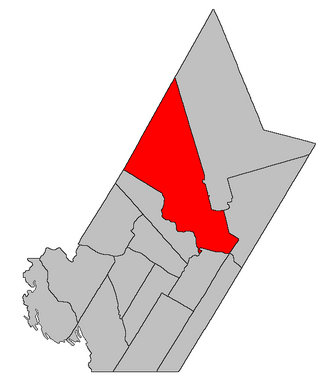
Location within Victoria County, New Brunswick.
Coordinates: 46°42′18″N67°45′36″W / 46.705°N 67.76°W / 46.705; -67.76
Country Flag of Canada (Pantone).svg  Canada
Province Flag of New Brunswick.svg  New Brunswick
County Victoria
Erected1833
Area
[1]
  Land123.42 km2 (47.65 sq mi)
Population
 (2021) [1]
  Total879
  Density7.1/km2 (18/sq mi)
  Change 2016-2021
Decrease2.svg 1.3%
  Dwellings
387
Time zone UTC-4 (AST)
  Summer (DST) UTC-3 (ADT)
Figures do not include portions within the villages of Aroostook and Perth-Andover

Andover is a geographic parish in Victoria County, New Brunswick, Canada. [2]

Contents

Prior to the 2023 governance reform, for governance purposes it was divided between the villages of Aroostook and Perth-Andover [3] and the local service district of the parish of Andover, [4] all of which were members of the Western Valley Regional Service Commission (WVRSC). [5]

Origin of name

Historian William F. Ganong related that the local explanation was that it was named by a Mr. Sisson, who came from Andover, England. [6]

History

Andover was erected in 1833 in Carleton County from Kent Parish. [7] The parish extended to above Grand Falls, New Brunswick, taking in most of Grand Falls Parish.

In 1850 the parish was extended north to where the Saint John River crosses the international boundary. [8]

In 1853 all of Andover north of the Aroostook River was included in the newly erected Grand Falls Parish. [9]

Boundaries

Andover Parish is bounded: [2] [10] [11]

Communities

Communities at least partly within the parish. [10] [11] [12] bold indicates an incorporated municipality

Bodies of water

Bodies of water [lower-alpha 1] at least partly within the parish. [10] [11] [12]

Other notable places

Parks, historic sites, and other noteworthy places at least partly within the parish. [10] [11] [12] [13]

Demographics

Parish population totals do not include the former incorporated villages of Aroostook and portion within Perth-Andover. Revised census figures based on the 2023 local governance reforms have not been released.

See also

Notes

  1. Not including brooks, ponds or coves.

Related Research Articles

<span class="mw-page-title-main">Moncton Parish, New Brunswick</span> Parish in New Brunswick, Canada

Moncton is a geographic parish in Westmorland County, New Brunswick, Canada.

<span class="mw-page-title-main">Acadieville Parish, New Brunswick</span> Parish in New Brunswick, Canada

Acadieville is a geographic parish in Kent County, New Brunswick, Canada.

<span class="mw-page-title-main">Dumfries Parish, New Brunswick</span> Parish in New Brunswick, Canada

Dumfries is a geographic parish in York County, New Brunswick, Canada.

<span class="mw-page-title-main">Hampstead Parish, New Brunswick</span> Parish in New Brunswick, Canada

Hampstead is a geographic parish in Queens County, New Brunswick, Canada.

<span class="mw-page-title-main">Wicklow Parish, New Brunswick</span> Parish in New Brunswick, Canada

Wicklow is a geographic parish in Carleton County, New Brunswick, Canada, forming the northwestern corner of Carleton County.

<span class="mw-page-title-main">Coverdale Parish, New Brunswick</span> Parish in New Brunswick, Canada

Coverdale is a geographic parish in Albert County, New Brunswick, Canada, located along the Petitcodiac River opposite Moncton and Dieppe.

<span class="mw-page-title-main">Madawaska Parish, New Brunswick</span> Parish in New Brunswick, Canada

Madawaska is a geographic parish in Madawaska County, New Brunswick, Canada.

<span class="mw-page-title-main">Newcastle Parish, New Brunswick</span> Parish in New Brunswick, Canada

Newcastle is a geographic parish in Northumberland County, New Brunswick, Canada.

<span class="mw-page-title-main">Chatham Parish, New Brunswick</span> Parish in New Brunswick, Canada

Chatham is a geographic parish in Northumberland County, New Brunswick, Canada.

<span class="mw-page-title-main">Blackville Parish, New Brunswick</span> Parish in New Brunswick, Canada

Blackville is a geographic parish in Northumberland County, New Brunswick, Canada.

<span class="mw-page-title-main">Gordon Parish, New Brunswick</span> Parish in New Brunswick, Canada

Gordon is a geographic parish in Victoria County, New Brunswick, Canada.

<span class="mw-page-title-main">Perth Parish, New Brunswick</span> Parish in New Brunswick, Canada

Perth is a geographic parish in Victoria County, New Brunswick, Canada.

<span class="mw-page-title-main">Grand Falls Parish, New Brunswick</span> Parish in New Brunswick, Canada

Grand Falls is a geographic parish in Victoria County, New Brunswick, Canada; the legal name in French is Grand-Sault, the only parish with different legal English and French names.

<span class="mw-page-title-main">Huskisson Parish, New Brunswick</span> Parish in New Brunswick, Canada

Huskisson is a geographic parish in Kent County, New Brunswick, Canada.

<span class="mw-page-title-main">Kent Parish, New Brunswick</span> Parish in New Brunswick, Canada

Kent is a geographic parish in the northeastern corner of Carleton County, New Brunswick, Canada.

<span class="mw-page-title-main">New Maryland Parish, New Brunswick</span> Parish in New Brunswick, Canada

New Maryland is a geographic parish in York County, New Brunswick, Canada.

<span class="mw-page-title-main">Douglas Parish, New Brunswick</span> Parish in New Brunswick, Canada

Douglas is a geographic parish in York County, New Brunswick, Canada.

<span class="mw-page-title-main">Maugerville Parish, New Brunswick</span> Parish in New Brunswick, Canada

Maugerville is a geographic parish in Sunbury County, New Brunswick, Canada.

<span class="mw-page-title-main">Hillsborough Parish, New Brunswick</span> Parish in New Brunswick, Canada

Hillsborough is a geographic parish in eastern Albert County, New Brunswick, Canada.

<span class="mw-page-title-main">Sheffield Parish, New Brunswick</span> Parish in New Brunswick, Canada

Sheffield is a geographic parish in Sunbury County, New Brunswick, Canada.

References

  1. 1 2 "Profile Page". Statistics Canada. 26 October 2022. Retrieved 29 October 2022.
  2. 1 2 "Chapter T-3 Territorial Division Act". Government of New Brunswick. Retrieved 13 November 2020.
  3. "New Brunswick Regulation 85-6 under the Municipalities Act (O.C. 85-45)". Government of New Brunswick. Retrieved 23 July 2020.
  4. "New Brunswick Regulation 84-168 under the Municipalities Act (O.C. 84-582)". Government of New Brunswick. Retrieved 23 July 2020.
  5. "Communities in each of the 12 Regional Service Commissions (RSC) / Les communautés dans chacune des 12 Commissions de services régionaux (CSR)" (PDF), Government of New Brunswick, July 2017, retrieved 1 February 2021
  6. Ganong, William F. (1906). Additions and Corrections to Monographs on the Place-Nomenclature, Cartography, Historic Sites, Boundaries and Settlement-origins of the Province of New Brunswick. Royal Society of Canada. p. 15. Retrieved 12 April 2021.
  7. "3 Wm. IV c. 17 An Act to divide the Parish of Kent, in the County of Carleton, into Five Towns or Parishes.". Acts of the General Assembly of His Majesty's Province of New Brunswick, Passed in the Year 1833. Fredericton: Government of New Brunswick. 1833. pp. 114–115. Retrieved 27 March 2021.
  8. "13 Vic. c. 51 An Act to consolidate all the Laws now in force for the division of the Province into Counties, Towns and Parishes.". Acts of the General Assembly of Her Mjaesty's Province of New Brunswick, Passed in the Year 1850. Fredericton: Government of New Brunswick. 1850. pp. 142–152, 145–149. Retrieved 27 March 2021. Book was poorly proofread, resulting in title typo and reuse of page numbers 145–152.
  9. "15 Vic. c. 35 An Act to erect part of the Parish of Andover, the County of Victoria, into a separate Parish.". Acts of the General Assembly of Her Majesty's Province of New Brunswick, Passed in the Year 1852. Fredericton: Government of New Brunswick. 1852. p. 55. Retrieved 27 March 2021.
  10. 1 2 3 4 "No. 72". Provincial Archives of New Brunswick. Department of Natural Resources and Energy Development. Retrieved 23 June 2021. Remainder of parish on map 81 at same site.
  11. 1 2 3 4 "208" (PDF). Transportation and Infrastructure. Government of New Brunswick. Retrieved 23 June 2021. Remainder of parish on mapbooks 223, 239, and 255 at same site.
  12. 1 2 3 "Search the Canadian Geographical Names Database (CGNDB)". Government of Canada. Retrieved 3 July 2021.
  13. "Explore New Brunswick's Protected Natural Areas". GeoNB. Retrieved 3 July 2021.
  14. Statistics Canada: 1996, 2001, 2006 census
  15. 2011 Statistics Canada Census Profile: Andover Parish, New Brunswick
  16. 1 2 "Census Profile, 2016 Census: Andover, Parish [Census subdivision], New Brunswick". Statistics Canada. Retrieved 2 October 2019.


46°42′18″N67°45′36″W / 46.70500°N 67.76000°W / 46.70500; -67.76000 (Andover Parish, New Brunswick)