
The Golden Gate Bridge is a suspension bridge spanning the Golden Gate, the one-mile-wide (1.6 km) strait connecting San Francisco Bay and the Pacific Ocean. The structure links the U.S. city of San Francisco, California—the northern tip of the San Francisco Peninsula—to Marin County, carrying both U.S. Route 101 and California State Route 1 across the strait. It also carries pedestrian and bicycle traffic, and is designated as part of U.S. Bicycle Route 95. Recognized by the American Society of Civil Engineers as one of the Wonders of the Modern World, the bridge is one of the most internationally recognized symbols of San Francisco and California.

San Francisco Bay is a large tidal estuary in the U.S. state of California, and gives its name to the San Francisco Bay Area. It is dominated by the cities of San Francisco, San Jose, and Oakland.

San Francisco, officially the City and County of San Francisco, is a commercial, financial, and cultural center of Northern California. The city proper is the fourth most populous in California, with 808,437 residents as of 2022, and covers a land area of 46.9 square miles, at the end of the San Francisco Peninsula, making it the second most densely populated large U.S. city after New York City and the fifth-most densely populated U.S. county, behind only four of the five New York City boroughs. Among the 91 U.S. cities proper with over 250,000 residents, San Francisco was ranked first by per capita income and sixth by aggregate income as of 2021. Colloquial nicknames for San Francisco include Frisco, San Fran, The City, and SF.

The Richmond District is a neighborhood in the northwest corner of San Francisco, California, developed initially in the late 19th century. It is sometimes confused with the city of Richmond, which is 20 miles (32 km) northeast of San Francisco.

Point Reyes National Seashore is a 71,028-acre (287.44 km2) park preserve located on the Point Reyes Peninsula in Marin County, California. As a national seashore, it is maintained by the US National Park Service as an important nature preserve. Some existing agricultural uses are allowed to continue within the park. Clem Miller, a US Congressman from Marin County, wrote and introduced the bill for the establishment of Point Reyes National Seashore in 1962 to protect the peninsula from development which was proposed at the time for the slopes above Drake's Bay.
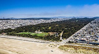
Golden Gate Park, located in San Francisco, California, United States, is a large urban park consisting of 1,017 acres (412 ha) of public grounds. It is administered by the San Francisco Recreation & Parks Department, which began in 1871 to oversee the development of Golden Gate Park. Configured as a rectangle, it is similar in shape to but 20 percent larger than Central Park in New York City, to which it is often compared. It is over three miles (4.8 km) long east to west, and about half a mile (0.8 km) north to south. With 24 million visitors annually, Golden Gate is the third most-visited city park in the United States after Central Park and the Lincoln Memorial.

The Palace of Fine Arts is a monumental structure located in the Marina District of San Francisco, California, originally constructed for the 1915 Panama–Pacific International Exposition to exhibit works of art. Completely rebuilt from 1964 to 1974, it is the only structure from the exposition that survives on site.

Lake Merritt is a large tidal lagoon in the center of Oakland, California, just east of Downtown. It is surrounded by parkland and city neighborhoods. It is historically significant as the United States' first official wildlife refuge, designated in 1870, and has been listed as a National Historic Landmark since 1963, and on the National Register of Historic Places since 1966.

The Marin Headlands is a hilly peninsula at the southernmost end of Marin County, California, United States, located just north of San Francisco across the Golden Gate Bridge, which connects the two counties and peninsulas. The entire area is part of the Golden Gate National Recreation Area. The Headlands are famous for their views of the Bay Area, especially of the Golden Gate Bridge.

Crissy Field is a public recreation area on the northern shore of the San Francisco Peninsula in California, United States, located just east of the Golden Gate Bridge. It includes restored tidal marsh and beaches.

The Golden Gate National Recreation Area (GGNRA) is a U.S. National Recreation Area protecting 82,116 acres (33,231 ha) of ecologically and historically significant landscapes surrounding the San Francisco Bay Area. Much of the park is land formerly used by the United States Army. GGNRA is managed by the National Park Service and is the most visited unit of the National Park system in the United States, with more than 15 million visitors a year. It is also one of the largest urban parks in the world, with a size two-and-a-half times that of the consolidated city and county of San Francisco.

San Francisco Bay in California has been served by ferries of all types for over 150 years. John Reed established a sailboat ferry service in 1826. Although the construction of the Golden Gate Bridge and the San Francisco–Oakland Bay Bridge led to the decline in the importance of most ferries, some are still in use today for both commuters and tourists.

Mountain Lake Park is a 14-acre (5.7 ha) San Francisco park in the Richmond District neighborhood, located north of the intersection of Lake and Funston. It was designed by engineer William Hammond Hall in the late 19th century, circa 1875. Hall also designed Golden Gate Park and was significantly influenced by Frederick Law Olmsted.
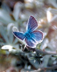
The Mission blue is a blue or lycaenid butterfly subspecies native to the San Francisco Bay Area of the United States. The butterfly has been declared as endangered by the US federal government. It is a subspecies of Boisduval's blue.

Seal Slough, also known as Marina Lagoon, is a narrow winding tidal channel through a tidal marsh in San Mateo and Foster City, California. This slough has been the object of a wetland restoration project in recent years to enhance habitat value. Dredging has been carried out in Seal Slough since at least 1954. When the original sewage treatment plant for the city of San Mateo was constructed in 1935, its discharge was directed to Seal Slough.

Golden Gate Ferry is a commuter ferry service operated by the Golden Gate Bridge, Highway and Transportation District in San Francisco Bay, part of the Bay Area of Northern California, United States. Regular service is run to the Ferry Building in San Francisco from Larkspur, Sausalito, Tiburon, and Angel Island in Marin County, with additional service from Larkspur to Oracle Park and Chase Center. The ferry service is funded primarily by passenger fares and Golden Gate Bridge tolls. In 2022, Golden Gate Ferry had a ridership of 1,022,800, or about 2,700 per weekday as of the fourth quarter of 2022.

Van Ness Bus Rapid Transit is a bus rapid transit (BRT) corridor on Van Ness Avenue in San Francisco, California, United States. The 1.96-mile (3.15 km) line, which runs between Mission Street and Lombard Street, has dedicated center bus lanes and nine stations. It was built as part of the $346 million Van Ness Improvement Project, which also included utility replacement and pedestrian safety features. Van Ness Bus Rapid Transit is used by several San Francisco Municipal Railway (Muni) lines including the 49 Van Ness–Mission, as well as three Golden Gate Transit routes.
San Elijo Lagoon Ecological Reserve is one of the largest remaining coastal wetlands in San Diego County, California, United States.

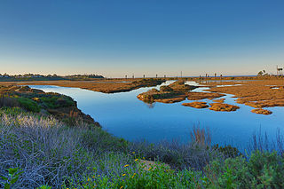
Crissy Marsh is a wetland area in San Francisco, California, United States. Crissy Marsh has brackish waters, making an ideal habitat for many bird species along the Pacific Flyway. Here, freshwater runoff meets the salt water of the bay. It is 130-acres and located on the northern end of the San Francisco Peninsula. This salt marsh was largely destroyed to build Crissy Field, an airfield used during World War I and World War II. It has since been restored, with the airfield being removed. It now hosts abundant and recovering wildlife on the northern San Francisco coast.