Ardsley, New York

Last updated
Ardsley, New York
Ardsley clock jeh.jpg
Downtown Ardsley
Ardsley, NY Seal.png
Ardsley, NY Logo.png
Westchester County New York incorporated and unincorporated areas Ardsley highlighted.svg
Location of Ardsley, New York
Coordinates: 41°0′41″N73°50′29″W / 41.01139°N 73.84139°W / 41.01139; -73.84139
Country United States
State New York
County Westchester
Town Greenburgh
Government
  MayorNancy Kaboolian [1]
Area
[2]
  Total1.32 sq mi (3.42 km2)
  Land1.32 sq mi (3.42 km2)
  Water0.00 sq mi (0.00 km2)
Elevation
210 ft (64 m)
Population
 (2020)
  Total5,079
  Density3,844.81/sq mi (1,484.49/km2)
Time zone UTC-5 (Eastern (EST))
  Summer (DST) UTC-4 (EDT)
ZIP Code
10502
Area code 914
FIPS code 36-02506
GNIS feature ID0942544
Website www.ardsleyvillage.com
Map of Ardsley Map Of Ardsley, NY crop.gif
Map of Ardsley
Ardsley Fire Department engine ArdsleyFD2.jpg
Ardsley Fire Department engine

Ardsley is a village in Westchester County, New York, United States. It is part of the town of Greenburgh. The village's population was 4,452 at the 2010 census. [3] The mayor of Ardsley is Nancy Kaboolian. [1]

Contents

The Ardsley post office serves the entire village of Ardsley, plus some nearby unincorporated sections of Greenburgh. The Ardsley Union Free School District includes the entire village of Ardsley plus parts of the village of Dobbs Ferry and unincorporated parts of Greenburgh. Ardsley has a library that is a member of the Westchester Library System.

Ardsley should not be confused with the nearby hamlet of Ardsley-on-Hudson, which is part of the village of Irvington.

History

Prior to European settlement Ardsley and its surrounding area was inhabited by the Wickquasgeck tribe, a band of the Wappinger, related to the Lenape (Delaware) tribes which dominated lower New York state and New Jersey. [4] [5]

After the Dutch came to the area, the land was part of the Bisightick tract of the van der Donck grant purchased by Frederick Philipse in 1682, first lord of Philipsburg Manor. In 1785 the state of New York confiscated the land from his Loyalist grandson, Frederick Philipse III, after he sided with the British in the American Revolution, and sold it to local farmers who had been tenants of the Phillipse family.

The village of Ashford was formed from some of these portions, named for the main road. Notable businesses included a blacksmith, and a sawmill and grist mill both situated upon the Saw Mill River. Three pickle factories were in operation by the Civil War, and in the 1880s the construction of the Putnam Railroad and New Croton Aqueduct led to a population boom which saw the installation of electric lighting and improved roads.

Due to the presence of an earlier Ashford Post Office in New York state, the town was forced to change its name in order to receive its own. The choice of "Ardsley" is attributed to Cyrus West Field, who owned 780 acres (3.2 km2) of land lying between Broadway (Dobbs Ferry) and Sprain Brook (Greenburgh) named Ardsley Park. He had named his home Ardsley Park after the English birthplace of his immigrant ancestor, Zechariah Field (East Ardsley, West Riding of Yorkshire, England), who immigrated to the U.S. in 1629. The story told at one time is that Field agreed to use his influence to get the post office established, and in return the village would be renamed Ardsley. [6] The first village postmaster was appointed in 1883.

Ardsley was incorporated as a town in 1896. Ardsley High School was established in 1912, with an addition in 1925. The town would continue to grow at a steady pace until a fire destroyed the village center in 1914. This led to the reconstruction of several buildings, and the establishment of a fire department in the former schoolhouse. Two population booms would follow, the first between the end of World War I and the beginning of the Great Depression, and the second following World War II. The Concord Road elementary school was built in 1953 with an addition in 1966. The town outgrew its original high school by the mid-1950s, resulting in the current facility being opened in 1957, and graduating its first class in 1958. The old school was converted into a middle school, until in 1971 the $5.5 million middle school was built.

The village was greatly changed during its second boom by the construction of the New York State Thruway in the late 1950s, which resulted in both the loss of the Ardsley station on the Putnam Division of the New York Central Railroad and the loss of much of the downtown business district.

Geography

According to the United States Census Bureau, the village has a total area of 1.3 square miles (3.4 km2), all land.

The Saw Mill River and Sprain Brook are two waterways that run through Ardsley. Over the years recurrent flooding along the Saw Mill River has caused damage to residential structures, commercial businesses, and industries as well as municipal infrastructure in Ardsley and other towns along the river. Recent severe floods occurred in March and April 1980, April 1984, and September 1999. The Army Corps of Engineers has completed several construction projects to help minimize potential damage from future floods in downtown Ardsley and surrounding areas. [7]

Climate

The climate in this area is characterized by hot, humid summers and generally mild to cool winters. According to the Köppen Climate Classification system, Ardsley has a humid subtropical climate, abbreviated "Cfa" on climate maps. [8]

It receives approximately 28 inches of snow per year. [9]

Demographics

Historical population
CensusPop.Note
1900 404
1910 53732.9%
1920 73035.9%
1930 1,13555.5%
1940 1,42325.4%
1950 1,74422.6%
1960 3,991128.8%
1970 4,47012.0%
1980 4,183−6.4%
1990 4,2722.1%
2000 4,269−0.1%
2010 4,4524.3%
2020 5,07914.1%
2021 (est.)5,006−1.4%
U.S. Decennial Census [10]

As of the census [11] of 2000, there were 4,269 people, 1,432 households, and 1,212 families residing in the village. The population density was 3,242.9 inhabitants per square mile (1,252.1/km2). There were 1,456 housing units at an average density of 1,106.0 per square mile (427.0/km2). The racial makeup of the village was 84.00% White, 1.52% African American, 0.09% Native American, 12.34% Asian, 0.02% Pacific Islander, 0.73% from other races, and 1.29% from two or more races. Hispanic or Latino of any race were 4.26% of the population.

There were 1,432 households, out of which 43.5% had children under the age of 18 living with them, 75.1% were married couples living together, 7.5% had a female householder with no husband present, and 15.3% were non-families. 12.9% of all households were made up of individuals, and 7.0% had someone living alone who was 65 years of age or older. The average household size was 2.96 and the average family size was 3.22.

In the village, the population was spread out, with 27.9% under the age of 18, 4.5% from 18 to 24, 24.5% from 25 to 44, 27.8% from 45 to 64, and 15.3% who were 65 years of age or older. The median age was 42 years. For every 100 females there were 96.1 males. For every 100 females age 18 and over, there were 93.2 males.

The median income for a household in the village was $105,293, and the median income for a family was $126,239. Males had a median income of $88,012 versus $57,216 for females. The per capita income for the village was $47,086. About 0.4% of families and 1.3% of the population were below the poverty line, including 0.4% of those under age 18 and 3.8% of those age 65 or over.

Per the U.S. Census Bureau's 2018 estimates 4,534 people lived in the village. [12] There were 1,688 housing units and the racial makeup of the village was 68.3% non-Hispanic white, 3.4% Black or African American, 0.2% American Indian or Alaska Native, 15.5% Asian, and 4.3% from two or more races. Hispanics or Latinos of any race made up 8.2% of the population.

Education

The Ardsley Union Free School District operates the village's public schools. Ardsley High School is the district's senior high school.

Lyceum Kennedy International School maintains its Ardsley campus, serving elementary grades.

Culture

In 2018 Brooke Lea Foster of The New York Times stated that it was one of several "Rivertowns" in New York State, even though physically Ardsley is not adjacent to a river; she described these "Rivertowns" as among the "least suburban of suburbs, each one celebrated by buyers there for its culture and hip factor, as much as the housing stock and sophisticated post-city life." [13] Of those, Foster stated that Ardsley was "the most landlocked". [13]

Infrastructure

Public transit

The Bee-Line Bus System serves Ardsley with several lines. Lines running north–south along Route 9A and 100B like 1C, 5, and 6 provide connections with Elmsford, White Plains, and Getty Square, Yonkers. Lines running east–west like 66 provide connections to commuter rail stations and the downtowns of Dobbs Ferry, Scarsdale, Larchmont, and New Rochelle.

With the demise of the New York and Putnam Railroad in favor of the construction of Interstate 87, commuter rail service to New York City is available via the Dobbs Ferry train station and Ardsley-on-Hudson train station, served by Metro-North Railroad's Hudson Line, and the Hartsdale train station and Scarsdale train station served by Metro-North Railroad's Harlem Line.

Pathways

There is also the motor-free South County Trail connecting Ardsley to the Empire State Trail across New York State. The trail is frequently used by bicyclists and pedestrians whether they just want to take a stroll or if they want to get to places, such as Elmsford or Yonkers. The trail runs along the path where the New York and Putnam Railroad once stood.

Notable people

See also

Related Research Articles

<span class="mw-page-title-main">Westchester County, New York</span> County in New York, United States

Westchester County is located in the U.S. state of New York. It is the seventh most populous county in the State of New York and the most populous north of New York City. According to the 2020 United States Census, the county had a population of 1,004,456, its highest decennial count ever and an increase of 55,344 (5.8%) from the 949,113 counted in 2010. Located in the Hudson Valley, Westchester covers an area of 450 square miles (1,200 km2), consisting of six cities, 19 towns, and 23 villages. Established in 1683, Westchester was named after the city of Chester, England. The county seat is the city of White Plains, while the most populous municipality in the county is the city of Yonkers, with 211,569 residents per the 2020 census.

<span class="mw-page-title-main">Putnam County, New York</span> County in New York, United States

Putnam County is a county located in the U.S. state of New York. As of the 2020 census, the population was 97,668. The county seat is Carmel, located within one of six towns comprising the county.

<span class="mw-page-title-main">Sleepy Hollow, New York</span> Village in New York, United States

Sleepy Hollow is a village in the town of Mount Pleasant, Westchester County,

<span class="mw-page-title-main">Cortlandt, New York</span> Town in New York, United States

Cortlandt is a town in Westchester County, New York, United States, located at the northwestern edge of the county, at the eastern terminus of the Bear Mountain Bridge. The town includes the villages of Buchanan and Croton-on-Hudson.

<span class="mw-page-title-main">Dobbs Ferry, New York</span> Village in New York, United States

Dobbs Ferry is a village in Westchester County, New York, United States. The population was 10,875 according to the 2010 United States Census. In 2021, its population rose to an estimated 11,456. The village of Dobbs Ferry is located in, and is a part of, the town of Greenburgh. The village ZIP Code is 10522. Most of the village falls within the boundaries of the Dobbs Ferry Union Free School District.

<span class="mw-page-title-main">Elmsford, New York</span> Village in New York, United States

Elmsford is a village in Westchester County, New York, United States. It is part of the New York metropolitan area. Roughly one square mile, the village is fully contained within the borders of the town of Greenburgh. As of the 2010 census, the population of Elmsford was 4,664.

<span class="mw-page-title-main">Greenburgh, New York</span> Town in New York, United States

Greenburgh is a town in western Westchester County, New York. The population was 95,397 at the time of the 2020 census.

<span class="mw-page-title-main">Edgemont, New York</span> Census-designated place in New York, United States

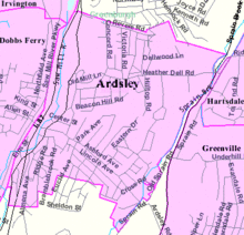
Greenville, commonly known as Edgemont, is a census-designated place (CDP) in the town of Greenburgh in Westchester County, New York, United States. The population was 9,394 at the 2020 census. Most of its residents refer to the area as Edgemont, which is also the name of its school district.

<span class="mw-page-title-main">Hastings-on-Hudson, New York</span> Village in New York, United States

Hastings-on-Hudson is a village in Westchester County located in the southwestern part of the town of Greenburgh in the state of New York, United States. It is located on the eastern bank of the Hudson River, approximately 20 miles (32 km) north of midtown Manhattan in New York City, and is served by a stop on the Metro-North Hudson Line. To the north of Hastings-on-Hudson is the village of Dobbs Ferry, to the south, the city of Yonkers, and to the east unincorporated parts of Greenburgh. As of the 2020 US Census, it had a population of 8,590. The town lies on U.S. Route 9, "Broadway" and the Saw Mill River Parkway.

<span class="mw-page-title-main">Irvington, New York</span> Village in New York, United States

Irvington, sometimes known as Irvington-on-Hudson, is a suburban village in the town of Greenburgh in Westchester County, New York, United States. It is located on the eastern bank of the Hudson River, 20 miles (32 km) north of midtown Manhattan in New York City, and is served by a station stop on the Metro-North Hudson Line. To the north of Irvington is the village of Tarrytown, to the south the village of Dobbs Ferry, and to the east unincorporated parts of Greenburgh, including East Irvington. Irvington includes within its boundaries the community of Ardsley-on-Hudson, which has its own ZIP code and Metro-North station, but which should not be confused with the nearby village of Ardsley.

<span class="mw-page-title-main">Lewisboro, New York</span> Town in New York, United States

Lewisboro is a town in Westchester County, New York, United States. The population was 12,411 at the 2010 census. The town is named after John Lewis, an early settler. Lewisboro is a suburb of New York City.

<span class="mw-page-title-main">Tarrytown, New York</span> Village in New York, United States

Tarrytown is a village in the town of Greenburgh in Westchester County, New York. It is located on the eastern bank of the Hudson River, approximately 25 miles (40 km) north of Midtown Manhattan in New York City, and is served by a stop on the Metro-North Hudson Line. To the north of Tarrytown is the village of Sleepy Hollow, to the south the village of Irvington and to the east unincorporated parts of Greenburgh. The Tappan Zee Bridge crosses the Hudson at Tarrytown, carrying the New York State Thruway to South Nyack, Rockland County and points in Upstate New York. The population was 11,860 at the 2020 census.

<span class="mw-page-title-main">Saw Mill River Parkway</span>

The Saw Mill River Parkway is a limited-access parkway that extends for 28.93 miles (46.56 km) through Westchester County, New York, in the United States. It begins at the border between Westchester County and the Bronx, as the continuation of the Henry Hudson Parkway leaving New York City, and heads generally northeastward to an interchange with Interstate 684 (I-684). At its north end, the parkway serves as a collector/distributor road as it passes east of the hamlet of Katonah. The parkway is named for the Saw Mill River, which the highway parallels for most of its length.

<span class="mw-page-title-main">Sprain Brook Parkway</span> North–south parkway in Westchester County, New York

The Sprain Brook Parkway is a 12.65-mile (20.36 km) controlled-access parkway in Westchester County, New York, United States. It begins at an interchange with the Bronx River Parkway in the city of Yonkers, and ends at the former site of the Hawthorne Circle, where it merges into the Taconic State Parkway. The parkway serves an alternate to the Bronx River Parkway, boasting an interchange connection through western Westchester with Interstate 287. New York's Department of Transportation (NYSDOT) refers to it internally as New York State Route 987F (NY 987F), an unsigned reference route.

<span class="mw-page-title-main">Albany Post Road</span>

The Albany Post Road was a post road – a road used for mail delivery – in the U.S. state of New York. It connected New York City and Albany along the east side of the Hudson River, a service now performed by U.S. Route 9 (US 9).

<span class="mw-page-title-main">Saw Mill River</span> River in the United States of America

The Saw Mill River is a 23.5-mile (37.8 km) tributary of the Hudson River in Westchester County, New York, United States. It flows from an unnamed pond north of Chappaqua to Getty Square in Yonkers, where it empties into the Hudson as that river's southernmost tributary. It is the only major stream in southern Westchester County to drain into the Hudson instead of Long Island Sound. It drains an area of 26.5 square miles (69 km2), most of it heavily developed suburbia. For 16 miles (26 km), it flows parallel to the Saw Mill River Parkway, a commuter artery, an association that has been said to give the river an "identity crisis."

<span class="mw-page-title-main">South County Trailway</span>

The South County Trailway is a 14.1-mile (22.7 km) long rail trail stretching from the Putnam Trail in Van Cortlandt Park in the Bronx to the North County Trailway in East View, New York. Westchester County Parks constructed the trailway in segments beginning in 1990 and completed it on October 31, 2017.

Thomas J. Abinanti is an American politician, lawyer, and former member of the New York State Assembly from Greenburgh, New York. A member of the Democratic Party, Abinanti was elected to the State Assembly in 2010 to replace Assemblyman Richard Brodsky, and represented central Westchester County, New York.

<span class="mw-page-title-main">National Register of Historic Places listings in southern Westchester County, New York</span>

This is a list of the National Register of Historic Places listings in southern Westchester County, New York, excluding the cities of New Rochelle and Yonkers, which have separate lists of their own.

<span class="mw-page-title-main">Woodlands Lake</span> Reservoir in Greenburgh, New York

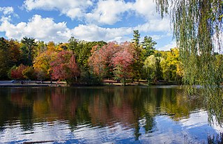
Woodlands Lake is a reservoir in Greenburgh, New York. It is an impoundment of the Saw Mill River. It is located in VE Macy Park.

References

  1. 1 2 "Board of Trustees". Village of Ardsley. Retrieved January 26, 2020.
  2. "ArcGIS REST Services Directory". United States Census Bureau. Retrieved September 20, 2022.
  3. "Profile of General Population and Housing Characteristics: 2010 Demographic Profile Data (DP-1): Ardsley village, Westchester County, New York". United States Census Bureau . Retrieved November 16, 2011.
  4. The name of the Indian band has variously been spelled Wiechquaeskeck, Wechquaesqueck, Weckquaesqueek, Wecquaesgeek, Weekquaesguk, Wickquasgeck, Wickquasgek, Wiequaeskeek, Wiequashook and Wiquaeskec. The spelling given here is one widely used for the original name of Broadway in lower Manhattan: "The Wickquasgeck Trail." The meaning of the name, however spelled, has been given as "the end of the marsh, swamp or wet meadow," "place of the bark kettle," and "birch bark country." See James Hammond Trumbull (1881). Indian Names of Places, Etc., in and on the Borders of Connecticut: With Interpretations of Some of Them. Hartford: Press of the Case, Lockwood & Brainard Company. p.  81.
  5. Henry Steiner, A Quick Chronology of Irvington, New York in the Early Days Archived 2011-07-11 at the Wayback Machine
  6. "History of the Atlantic Cable & Submarine Telegraphy - Descendants of Cyrus West Field". atlantic-cable.com. Retrieved 2021-09-20. The information about Zechariah Field and Ardsley Park came from Diane Druin Gravlee, great-great-granddaughter of Cyrus W. Field.
  7. "FACT SHEET- Saw Mill River at Elmsford and Greenburgh > New York District > Fact Sheet Article View". Archived from the original on 2016-10-19. Retrieved 2016-08-21.
  8. Climate Summary for Ardsley, New York
  9. "Climate in Zip 10502 (Ardsley, NY)". Bestplaces.net. Retrieved 2022-09-07.
  10. "Census of Population and Housing". Census.gov. Retrieved June 4, 2015.
  11. "U.S. Census website". United States Census Bureau . Retrieved 2008-01-31.
  12. "2018 ACS Demographic and Housing Estimates". data.census.gov. Retrieved 2020-02-01.
  13. 1 2 Foster, Brooke Lea (2018). "Comparing Suburbs: Montclair in New Jersey vs. Dobbs Ferry in New York". The New York Times .
  14. GOLDSMITH, John Lauinger, SAMUEL. "Hot 97's DJ Funkmaster Flex arrested; accused of shoving wife, sending text threats". nydailynews.com. Retrieved 2021-09-20.{{cite web}}: CS1 maint: multiple names: authors list (link)