Arlington, Vermont

Last updated

Arlington, Vermont
Downtown-arlington-vt.JPG
Downtown Arlington
Arlington vt highlight.png
Arlington, Vermont
Usa edcp location map.svg
Red pog.svg
Arlington
Location in Vermont
Coordinates: 43°4′29″N73°9′50″W / 43.07472°N 73.16389°W / 43.07472; -73.16389
Country United States
State Vermont
County Bennington
Communities Arlington
East Arlington
West Arlington
Area
  Total42.4 sq mi (109.9 km2)
  Land42.2 sq mi (109.4 km2)
  Water0.2 sq mi (0.5 km2)
Elevation
581 ft (177 m)
Population
 (2020)
  Total2,457
  Density58/sq mi (22.4/km2)
Time zone UTC−5 (Eastern (EST))
  Summer (DST) UTC−4 (EDT)
ZIP Code
05250
Area code 802
FIPS code 50-01450 [1]
GNIS feature ID1462027 [2]
Website www.arlingtonvt.org

Arlington is a town in Bennington County, Vermont, United States. The population was 2,457 at the 2020 census. [3]

Contents

History

The town of Arlington was chartered July 28, 1761, by New Hampshire Governor Benning Wentworth, as part of the New Hampshire Grants. In 1777, Arlington became the first capital of the Vermont Republic.

Among the first settlers in Arlington were Captain Jehiel Hawley and his family, who had settled there by 1764. They were Anglicans and had fled Roxbury, Connecticut, because of the oppressive requirements of the established Congregational church. At a Proprietor's meeting in 1764, the town voted to give 50 acres (20 hectares) of land to any man who would set up a gristmill in what is now East Arlington. This offer was accepted by Remember Baker (first cousin of Ethan Allen), who built a grist and sawmill.

In the years leading up to the American Revolution, both New York and New Hampshire laid claim to lands comprising current-day Vermont. The Province of New York began to grant land in 1765, lagging New Hampshire by four years. Arlington was, for the most part, settled by Anglicans from Roxbury, Newtown, and Milford, Connecticut, with ownership rights derived from the New Hampshire Grants.

When settlers with New York grants arrived, conflicts ensued. Among other things, the residents of Arlington relied on the militancy of Ethan Allen to discourage those touting New York grants. Ethan Allen and his group were known by their friends as the Green Mountain Boys. They were relatively effective in promoting the cause of New Hampshire grantees, although legal ownership was not settled monetarily for many years.

Several members of the Green Mountain Boys lived in Arlington before the American Revolution, including Thomas Chittenden, Seth Warner and Remember Baker, who was the first town clerk. Gideon Hard, a congressman from New York, was born in Arlington. [4] During the American Revolutionary War, the Patriot soldiers of the Green Mountain Boys rallied against Loyalist opposition in the town. British Loyalist citizens in Arlington, united under the leadership of Dr. Samuel Adams, organized an independent military unit, Adams' Rangers, to support the British war effort in the region. In 1777, Adams' men saw action, fighting for British General John Burgoyne at the Battle of Saratoga in the Province of New York and were soundly defeated.

Geography

Arlington lies in the Valley of Vermont between the Taconic Range to the west and the Green Mountains to the east, with most of Arlington's land mass lying in the Taconic Range. Five prominent peaks are located within the town: Grass Mountain, Spruce Peak, The Ball (also locally referred to as West Mountain), Red Mountain, and Big Spruce Mountain. The highest peak is Grass Mountain at elevation 3,109 ft (948 m).

According to the United States Census Bureau, the town has a total area of 42.4 square miles (109.9 km2), of which 42.2 square miles (109.4 km2) is land and 0.19 square miles (0.5 km2), or 0.45%, is water. [5] The Battenkill, famous for trout fishing, flows through the center of town.

Climate data for Arlington, Vermont
MonthJanFebMarAprMayJunJulAugSepOctNovDecYear
Mean daily maximum °C−1.90.94.912.418.824.125.825.120.914.17.71.312.9
Daily mean °C−7.2−5.3−1.05.911.916.919.218.313.87.72.7−3.46.7
Mean daily minimum °C−12.5−11.6−6.9−0.65.59.812.511.76.81.3−2.3−8.20.5
Average precipitation mm86.471.191.488.9109.2119.4116.8111.896.5109.2101.6101.61,201.4
Average snowfall cm49.842.233.010.41.510.243.7190.8
Mean daily maximum °F28.633.640.854.365.875.478.477.269.657.445.934.355.2
Daily mean °F19.022.530.242.653.462.466.664.956.845.936.925.944.1
Mean daily minimum °F9.511.119.630.941.949.654.553.144.234.327.917.232.9
Average precipitation inches3.402.803.603.504.304.704.604.403.804.304.004.0047.30
Average snowfall inches19.616.613.04.10.64.017.275.1
Average precipitation days14.711.213.512.614.313.312.611.811.012.312.914.7154.9
Average snowy days10.68.77.32.30.43.09.041.3
Source: [6]

Demographics

Historical population
CensusPop.Note
1790 991
1800 1,59761.2%
1810 1,463−8.4%
1820 1,354−7.5%
1830 1,207−10.9%
1840 1,035−14.3%
1850 1,0844.7%
1860 1,1465.7%
1870 1,63642.8%
1880 1,532−6.4%
1890 1,352−11.7%
1900 1,193−11.8%
1910 1,3079.6%
1920 1,3704.8%
1930 1,4415.2%
1940 1,418−1.6%
1950 1,4633.2%
1960 1,6059.7%
1970 1,93420.5%
1980 2,18412.9%
1990 2,2995.3%
2000 2,3974.3%
2010 2,317−3.3%
2020 2,4576.0%
U.S. Decennial Census [7]

As of the census [1] of 2000, there were 2,397 people, 1,009 households, and 676 families residing in the town. The population density was 56.5 people per square mile (21.8/km2). There were 1,200 housing units at an average density of 28.3 per square mile (10.9/km2). The racial makeup of the town was 98.08% White, 0.25% Black, 0.08% Native American, 0.42% Asian, 0.08% Pacific Islander, 0.21% from other races, and 0.88% from two or more races. Hispanic of any race were 0.46% of the population.

There were 1,009 households, out of which 28.5% had children under the age of 18 living with them, 56.3% were couples living together and joined in either marriage or civil union, 8.1% had a female householder with no husband present, and 33.0% were non-families. Of all households, 27.9% were made up of individuals, and 12.8% had someone living alone who was 65 years of age or older. The average household size was 2.38 and the average family size was 2.90.

In the town, the population was spread out, with 23.0% under the age of 18, 6.0% from 18 to 24, 26.2% from 25 to 44, 28.3% from 45 to 64, and 16.5% who were 65 years of age or older. The median age was 42 years. For every 100 females, there were 93.6 males. For every 100 women age 18 and over, there were 88.1 men.

The median income for a household in the town was $40,590, and the median income for a family was $49,412. Males had a median income of $31,250 versus $22,199 for females. The per capita income for the town was $23,277. About 6.4% of families and 7.2% of the population were below the poverty line, including 9.3% of those under age 18 and 7.2% of those age 65 or over.

Education

Schools in Arlington include Arlington Memorial School, a high school with some 250 students. [8]

Economy

One of the largest employers for residents of Arlington is the Orvis company in neighboring Sunderland. [9]

Mack Moulding is the largest employer in Arlington by far. Orvis has its offices in Sunderland and a retail outlet in Manchester Center.

Notable people

See also

Related Research Articles

<span class="mw-page-title-main">Windsor County, Vermont</span> County in Vermont, United States

Windsor County is a county located in the U.S. state of Vermont. As of the 2020 census, the population was 57,753. The shire town is the town of Woodstock. The county's largest municipality is the town of Hartford.

<span class="mw-page-title-main">Windham County, Vermont</span> County in Vermont, United States

Windham County is a county located in the U.S. state of Vermont. As of the 2020 census, the population was 45,905. The shire town is Newfane, and the largest municipality is the town of Brattleboro.

<span class="mw-page-title-main">Bennington County, Vermont</span> County in Vermont, United States

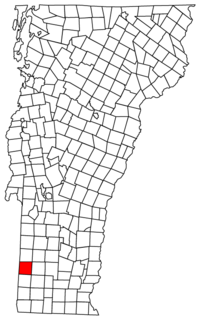
Bennington County is a county in the U.S. state of Vermont. As of the 2020 census, the population was 37,347. The shire towns are jointly Bennington and Manchester, and the largest municipality is Bennington. The county was created in 1778.

<span class="mw-page-title-main">Addison County, Vermont</span> County in Vermont, United States

Addison County is a county located in the U.S. state of Vermont. As of the 2020 census, the population was 37,363. Its shire town is the town of Middlebury.

<span class="mw-page-title-main">Hancock, Vermont</span> Town in Vermont, United States

Hancock is a town in Addison County, Vermont, United States. The town was named for John Hancock. The population was 359 at the 2020 census. Hancock is home to the Middlebury College Snow Bowl and contains Middlebury Gap through the Green Mountains.

<span class="mw-page-title-main">Starksboro, Vermont</span> Town in Vermont, United States

Starksboro is a town in Addison County, Vermont, United States. The population was 1,756 at the 2020 census.

<span class="mw-page-title-main">Dorset, Vermont</span> Town in Vermont, United States

Dorset is a town in Bennington County, Vermont, United States. The population was 2,133 at the 2020 census. Dorset is famous for being the location of Cephas Kent's Inn, where four meetings of the Convention that signed the Dorset Accords led to the independent Vermont Republic and future statehood. Dorset is the site of America's oldest marble quarry and is the birthplace of Bill W., co-founder of Alcoholics Anonymous. East Dorset is the site of the Wilson House and the Griffith Library. The town is named after the English county of Dorset.

<span class="mw-page-title-main">Glastenbury, Vermont</span> Ghost town in Vermont, United States

Glastenbury is a town in Bennington County, Vermont, United States. The town was unincorporated by an act of the state legislature in 1937. The population was 9 at the 2020 census. Along with Somerset, Glastenbury is one of two Vermont towns where the population levels have dropped so low that the town has been unincorporated. The town has no local government and the town's affairs are handled by a state-appointed supervisor.

<span class="mw-page-title-main">North Bennington, Vermont</span> Village in Vermont, United States

North Bennington is an incorporated village in the town of Bennington in Bennington County, Vermont, United States. The population was 1,716 at the 2020 census.

<span class="mw-page-title-main">Pownal, Vermont</span> Town in Vermont, United States

Pownal is a town in Bennington County, Vermont, United States. As of the 2020 census, the town population was 3,258. The town of Pownal includes the villages of Pownal, North Pownal, and Pownal Center.

<span class="mw-page-title-main">Rupert, Vermont</span> Town in Vermont, United States

Rupert is a town in Bennington County, Vermont, United States. The population was 698 at the 2020 census.

<span class="mw-page-title-main">Sandgate, Vermont</span> Town in Vermont, United States

Sandgate is a town in Bennington County, Vermont, United States. The population was 387 at the 2020 census.

<span class="mw-page-title-main">Sunderland, Vermont</span> Town in Vermont, United States

Sunderland is a town in Bennington County, Vermont, United States. The population was 1,056 at the 2020 census. It is home to the mail-order company Orvis.

<span class="mw-page-title-main">Pawlet, Vermont</span> Town in Vermont, United States

Pawlet is a town in Rutland County, Vermont, United States. The population was 1,424 at the 2020 census.

<span class="mw-page-title-main">Dummerston, Vermont</span> Town in Vermont, United States

Dummerston is a town in Windham County, Vermont, United States. The population was 1,865 at the 2020 census. It is home to the longest covered bridge still in use in Vermont. Its borders include three main villages: Dummerston Center, West Dummerston, and East Dummerston.

<span class="mw-page-title-main">Williamstown, Massachusetts</span> Town in Massachusetts, United States

Williamstown is a town in Berkshire County, Massachusetts, United States. It shares a border with Vermont to the north and New York to the west. Located in Berkshire County, the town is part of the Pittsfield, Massachusetts metropolitan statistical area. The population was 7,513 at the 2020 census. A college town, it is home to Williams College, the Clark Art Institute and the Tony-awarded Williamstown Theatre Festival.

<span class="mw-page-title-main">Middlebury, Vermont</span> Town in Vermont, United States

Middlebury is the shire town of Addison County, Vermont, United States. As of the 2020 census, the population was 9,152. Middlebury is home to Middlebury College and the Henry Sheldon Museum of Vermont History.

<span class="mw-page-title-main">Manchester (village), Vermont</span> Village in Vermont, United States

Manchester is an incorporated village in the town of Manchester, Bennington County, Vermont, United States. The population was 783 at the 2020 census.

<span class="mw-page-title-main">Manchester, Vermont</span> Town in Vermont, United States

Manchester is a town in, and one of two shire towns of, Bennington County, Vermont, United States. The population was 4,484 at the 2020 census.

<span class="mw-page-title-main">Arlington (CDP), Vermont</span> Census-designated place in Vermont, United States

Arlington is a census-designated place (CDP) in the towns of Arlington and Sunderland, Bennington County, Vermont, United States. The population was 1,213 at the 2010 census.

References

  1. 1 2 "U.S. Census website". United States Census Bureau . Retrieved January 31, 2008.
  2. "US Board on Geographic Names". United States Geological Survey. October 25, 2007. Retrieved January 31, 2008.
  3. "Census - Geography Profile: Arlington town, Bennington County, Vermont". United States Census Bureau . Retrieved December 27, 2021.
  4. Who Was Who in America, Historical Volume. Chicago: Marquis Who's Who. 1963.
  5. "Geographic Identifiers: 2010 Demographic Profile Data (G001): Arlington town, Bennington County, Vermont". U.S. Census Bureau, American Factfinder. Archived from the original on February 12, 2020. Retrieved April 25, 2014.
  6. "www.weatherbase.com" . Retrieved May 15, 2015.
  7. "U.S. Decennial Census". United States Census Bureau. Retrieved May 16, 2015.
  8. "About". Arlington Memorial High School. Archived from the original on March 22, 2018. Retrieved March 21, 2018.
  9. Petras, Kathryn (1991). Jobs '92. Prentice Hall Press. ISBN   978-0-13-512351-5.
  10. "Actor Alec Baldwin has purchased a farmhouse and land in Arlington, Vt".
  11. Wiley, Edgar J. (1917). Catalogue of Officers and Students of Middlebury College in Middlebury, Vermont, 1800-1915. Middlebury: Middlebury College. pp. 22–23.
  12. Perlis, Vivian (1974). Charles Ives Remembered: An Oral History. University of Illinois Press. ISBN   9780252070785.