Asbury, Iowa

Last updated

Asbury, Iowa
Motto: 
"You're Home."
Dubuque County Iowa Incorporated and Unincorporated areas Asbury Highlighted.svg
Location in the State of Iowa
Coordinates: 42°30′56″N90°45′48″W / 42.51556°N 90.76333°W / 42.51556; -90.76333
Country Flag of the United States.svg  United States
State Flag of Iowa.svg  Iowa
County Dubuque
Founded1830s
Incorporated 1933
Government
   Mayor Jim Adams
Area
[1]
   City 3.18 sq mi (8.22 km2)
  Land3.18 sq mi (8.22 km2)
  Water0.00 sq mi (0.00 km2)
Elevation
932 ft (284 m)
Population
 (2020)
   City 5,943
  Density1,871.22/sq mi (722.55/km2)
   Metro
92,359
Time zone UTC-6 (CST)
  Summer (DST) UTC-5 (CDT)
ZIP code
52002
Area code 563
FIPS code 19-03160
GNIS feature ID0454247
Website www.cityofasbury.com

Asbury is a city in Dubuque County, Iowa, United States, and adjacent to the westside of the city of Dubuque. It is part of the Dubuque, Iowa Metropolitan Statistical Area. The population was 5,943 at the 2020 census. [2] Asbury is the second-largest city in Dubuque County, surpassing Dyersville to become the second-largest in the 2010 U.S. Census count. The city is largely a bedroom community, made up of subdivisions whose residents work in Dubuque or Peosta.[ citation needed ]

Contents

History

Asbury was settled beginning in the 1830s, at first by Methodists. The city is named after British-born Bishop Francis Asbury, one of the first two bishops of the Methodist Episcopal Church in the United States. The city was incorporated in 1933, following the passage of the Twenty-first Amendment to the United States Constitution, which ended prohibition. The city incorporated to gain the legal standing necessary to sell alcohol, as liquor licenses were still forbidden in rural areas. [3]

For most of its history, Asbury was very small, much like hundreds of other towns in rural Iowa. In the 1960 census, Asbury still had only 71 residents. During this time, the City of Dubuque grew immensely, and the sprawl reached the Asbury area beginning in the 1960s. By 1970, Asbury had 410 residents and had grown fast enough to become the fastest growing city in the state of Iowa. [3]

Asbury continues to grow at a rapid pace today, expanding over 50% since the year 2000, and currently (2020) counts 5,943 residents. This number is increasing, as a number of new subdivisions are being built or planned for the area.

Law and government

Asbury has a mayor–council form of government, employing a full-time city administrator, and part-time city council (mayor and 5 at-large city council members). The city administrator is Beth Bonz, the current mayor is Jim Adams, and the council members are: Bob Reisch, Craig Miller, John Richey, Curt Kiessling and Larry Nagle. The city council meets at 7 P.M. on the second and fourth Tuesdays of every month at Asbury City Hall. [4]

The city council works on the advice of a number of citizen committees, including the following: Building Code Commission, Park & Recreation Board, Planning & Zoning Commission, Zoning Board of Adjustment, and the Water Board. In addition, Asbury sends commissioners to the Eastern Iowa Housing Authority. [5]

Asbury has 3 city departments: Public Safety (police & fire), Public Works, and Parks.

In the Iowa General Assembly, Asbury is represented by Senator Carrie Koelker (Republican), and Representative Shannon Lundgren (Republican) in the Iowa House of Representatives. [6] At the federal level, it is within Iowa's 1st congressional district, represented by Ashley Hinson (R) in the U.S. House of Representatives. Asbury, and all of Iowa, are represented by U.S. Senators Chuck Grassley (R) and Joni Ernst (R).

Geography

Asbury is located at 42°30′56″N90°45′48″W / 42.51556°N 90.76333°W / 42.51556; -90.76333 (42.515648, -90.763235). [7]

According to the United States Census Bureau, the city has a total area of 2.66 square miles (6.89 km2), all land. [8]

The city operates four parks and pedestrian and mountain bike trails. The parks include: Althaus Wetland & Nature Preserve, Asbury Park, Cloie Creek Park, and Maple Hills Park. The trail runs from Asbury Rd. to Maple Hills Park, and is part of Asbury's plan for having a citywide trail network. [9]

Economy

Serving primarily as a bedroom community, Asbury has only a small local economy. Most of its residents commute to work in Dubuque. Only a handful of businesses operate within the City of Asbury, however, this number has grown in recent years, along with an expanding population. Most people who do work in Asbury either are employed by the city government, or in the service-related businesses along Asbury and Saratoga Roads.

Demographics

Historical populations
YearPop.±%
1940 27    
1950 52+92.6%
1960 71+36.5%
1970 410+477.5%
1980 2,017+392.0%
1990 2,013−0.2%
2000 2,450+21.7%
2010 4,170+70.2%
2020 5,943+42.5%
Source: "U.S. Census website". United States Census Bureau . Retrieved March 28, 2020. and Iowa Data Center
Source:
U.S. Decennial Census [10] [2]
The population of Asbury, Iowa from US census data AsburyIowaPopPlot.png
The population of Asbury, Iowa from US census data

2010 census

As of the census [11] of 2010, there were 4,170 people, 1,433 households, and 1,164 families residing in the city. The population density was 1,567.7 inhabitants per square mile (605.3/km2). There were 1,463 housing units at an average density of 550.0 per square mile (212.4/km2). The racial makeup of the city was 96.8% White, 1.0% African American, 1.1% Asian, 0.3% from other races, and 0.8% from two or more races. Hispanic or Latino of any race were 1.4% of the population.

There were 1,433 households, of which 45.4% had children under the age of 18 living with them, 71.5% were married couples living together, 7.0% had a female householder with no husband present, 2.8% had a male householder with no wife present, and 18.8% were non-families. 15.3% of all households were made up of individuals, and 5.7% had someone living alone who was 65 years of age or older. The average household size was 2.91 and the average family size was 3.27.

The median age in the city was 35.6 years. 32.9% of residents were under the age of 18; 6% were between the ages of 18 and 24; 26% were from 25 to 44; 25.4% were from 45 to 64; and 9.9% were 65 years of age or older. The gender makeup of the city was 49.2% male and 50.8% female.

2000 census

As of the census [12] of 2000, there were 2,450 people, 846 households, and 728 families residing in the city. The population density was 971.8 inhabitants per square mile (375.2/km2). There were 867 housing units at an average density of 343.9 per square mile (132.8/km2). The racial makeup of the city was 98.49% White, 0.49% African American, 0.37% Asian, 0.04% Pacific Islander, 0.24% from other races, and 0.37% from two or more races. Hispanic or Latino of any race were 0.73% of the population.

There were 846 households, out of which 44.4% had children under the age of 18 living with them, 77.8% were married couples living together, 6.6% had a female householder with no husband present, and 13.9% were non-families. 11.0% of all households were made up of individuals, and 2.8% had someone living alone who was 65 years of age or older. The average household size was 2.90 and the average family size was 3.13.

30.7% are under the age of 18, 7.1% from 18 to 24, 27.7% from 25 to 44, 27.8% from 45 to 64, and 6.7% who were 65 years of age or older. The median age was 36 years. For every 100 females, there were 98.5 males. For every 100 females age 18 and over, there were 98.5 males.

The median income for a household in the city was $60,100, and the median income for a family was $64,097. Males had a median income of $41,935 versus $25,337 for females. The per capita income for the city was $21,447. About 4.5% of families and 4.0% of the population were below the poverty line, including 4.3% of those under age 18 and 7.9% of those age 65 or over.

Education

All students living in Asbury are zoned to schools in the Dubuque Community School District. Elementary school students living in the central, eastern, and southern parts of Asbury are zoned to Carver Elementary School. [13] Other students in northern, western, and southwestern Asbury (Arrowhead, Brook Haven, Forest Hills, Long Grove, Wedgewood) are zoned to Kennedy Elementary School. [14] Asbury's middle school students are zoned to Roosevelt Middle School, [15] and high school students are zoned to Hempstead High School. [16]

There are no private schools currently operating in Asbury, but many parochial school students attend private schools in Dubuque, as they are open to anyone, regardless of location. Many of these students are enrolled in the Holy Family Catholic School System, and attend nearby Resurrection Elementary School, Mazzuchelli Middle School, and Wahlert High School. There is also a private elementary school serving the Lutheran community in the area, the Dubuque Lutheran School (LCMS affiliated).

Neighborhoods

Asbury is a city of neighborhoods. Since the city is very young, and much of its growth has occurred only recently, its subdivisions are still clearly identifiable. Generally, eastern and southern parts of the city are older, while northern and western areas are of entirely new construction. Asbury's "main street" is Asbury Road, and most of the neighborhoods branch off of this artery. The city is growing at a phenomenal clip, adding 544 new single-family homes since 2000.

Related Research Articles

<span class="mw-page-title-main">Dubuque County, Iowa</span> County in Iowa, United States

Dubuque County is a county located in the U.S. state of Iowa. As of the 2020 census, the population was 99,266, making it the eighth-most populous county in Iowa. The county seat is Dubuque. The county is named for Julien Dubuque, the first European settler of Iowa.

<span class="mw-page-title-main">Grand Mound, Iowa</span> City in Iowa, United States

Grand Mound is a city in Clinton County, Iowa, United States. The population was 615 at the time of the 2020 census.

<span class="mw-page-title-main">Dyersville, Iowa</span> City in Iowa, United States

Dyersville is a city in eastern Delaware County and western Dubuque County in the U.S. state of Iowa. It is part of the Dubuque, Iowa, Metropolitan Statistical Area. The population was 4,477 at the time of the 2020 census, up from 4,035 in 2000.

<span class="mw-page-title-main">Balltown, Iowa</span> City in Iowa, United States

Balltown is a city in Dubuque County, Iowa, United States. It is part of the Dubuque, Iowa Metropolitan Statistical Area. The population was 79 at the 2020 census, up from 73 in 2000. Balltown is home to Breitbach's Country Dining, Iowa's oldest restaurant and bar, which was founded in 1852 and twice rebuilt by the community, following its destruction by fire in 2007 and 2008.

<span class="mw-page-title-main">Bankston, Iowa</span> City in Iowa, United States

Bankston is a city in Dubuque County, Iowa, United States. It is part of the 'Dubuque, Iowa Metropolitan Statistical Area'. The population was 23 at the 2020 census, down from 27 in 2000.

<span class="mw-page-title-main">Bernard, Iowa</span> City in Iowa, United States

Bernard is a city in Dubuque County, Iowa, United States. The population was 114 in the 2020 census, an increase from the 97 population in 2000. Bernard is part of the Dubuque, Iowa Metropolitan Statistical Area.

<span class="mw-page-title-main">Cascade, Iowa</span> City in Iowa, United States

Cascade is a city in Dubuque and Jones counties, Iowa, United States. The Dubuque County portion is part of Dubuque Metropolitan Statistical Area, while the Jones County section is part of Cedar Rapids Metropolitan Statistical Area. The population was 2,386 at the 2020 census, up from 1,958 in 2000. The city is located within southwestern of Dubuque County and north-central Jones County.

<span class="mw-page-title-main">Centralia, Iowa</span> City in Iowa, United States

Centralia is a city in Dubuque County, Iowa, United States. It is part of the Dubuque, Iowa Metropolitan Statistical Area. The population was 116 at the 2020 census, up 15 persons since the 2000 census and down 18 from the 2010.

<span class="mw-page-title-main">Epworth, Iowa</span> City in Iowa, United States

Epworth is a city in Dubuque County, Iowa, United States. It is part of the Dubuque, Iowa Metropolitan Statistical Area. The population was 2,023 at the 2020 census, up from 1,428 in 2000.

<span class="mw-page-title-main">Farley, Iowa</span> City in Iowa, United States

Farley is a city in Dubuque County, Iowa, United States. It is part of the Dubuque, Iowa Metropolitan Statistical Area. The population was 1,766 at the time of the 2020 census, up from 1,334 in 2000. Farley is the seventh-largest town in Dubuque County, recently passed by Peosta, Iowa.

<span class="mw-page-title-main">Holy Cross, Iowa</span> City in Iowa, United States

Holy Cross is a city in Dubuque County, Iowa, United States. It is part of the Dubuque, Iowa Metropolitan Statistical Area. The population was 356 at the time of the 2020 census, down from 399 in 2000.

<span class="mw-page-title-main">Luxemburg, Iowa</span> City in Iowa, United States

Luxemburg is a city in Dubuque County, Iowa, United States. It is part of the Dubuque, Iowa Metropolitan Statistical Area. The population was 245 at the time of the 2020 census, down from 246 in 2000. The White Pine Hollow State Forest is located four miles to the northwest of Luxemburg.

<span class="mw-page-title-main">New Vienna, Iowa</span> City in Iowa, United States

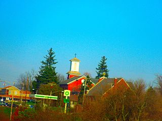
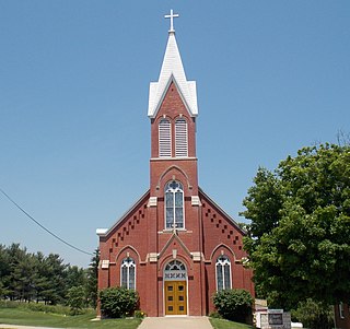
New Vienna is a city in Dubuque County, Iowa, United States. It is part of the Dubuque, Iowa Metropolitan Statistical Area. The population was 382 at the time of the 2020 census, down from 400 in 2000. New Vienna is the home to the Saint Boniface Catholic Church. The city promotes itself with the slogan The eNVy of Iowa.

<span class="mw-page-title-main">Peosta, Iowa</span> City in Iowa, United States

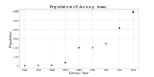
Peosta is a city in Dubuque County, Iowa, United States, and an exurb of the city of Dubuque. It is part of the Dubuque, Iowa Metropolitan Statistical Area. The population was 1,908 in the 2020 census, an increase of 193% from 651 in 2000. Peosta experienced a 70% increase in population (estimated) from 2000 to 2007, making it the state's 10th fastest-growing city during that period. Peosta is currently the sixth-largest city in Dubuque County, but it will likely soon pass Epworth (pop. 1,860) to become the fifth-largest. The community is home to the 2015 ASA D Northern Nationals Men's Slow Pitch Champions, Kass & Company, a large industrial park, the largest campus of Northeast Iowa Community College, and a handful of new commercial businesses. However, the city is increasingly becoming a bedroom community, much like nearby Asbury, made up of suburban subdivisions.

<span class="mw-page-title-main">Rickardsville, Iowa</span> City in Iowa, United States

Rickardsville is a city in Dubuque County, Iowa, United States. The population was 202 at the time of the 2020 census, up from 191 in 2000.

<span class="mw-page-title-main">Worthington, Iowa</span> City in Iowa, United States

Worthington is a city in Dubuque County, Iowa, United States. The population was 382 at the time of the 2020 census, up from 381 in 2000. Iowa Highway 136 passes through Worthington, which is situated north of Cascade and south of Dyersville.

<span class="mw-page-title-main">Bellevue, Iowa</span> City in Iowa, United States

Bellevue is a city in eastern Jackson County, Iowa, United States. The city lies along the Mississippi River and next to Bellevue State Park. In 2020 its population was 2,363; up from a count of 2,191 at the 2010 Census, making it the second-largest and only growing city in Jackson County.

<span class="mw-page-title-main">Maquoketa, Iowa</span> City in Iowa, United States

Maquoketa is a city in Jackson County, Iowa, United States. Located on the Maquoketa River, it is the county seat of Jackson County.

<span class="mw-page-title-main">Mount Ayr, Iowa</span> City in Iowa, United States

Mount Ayr is a city in Ringgold County, Iowa, United States. The population was 1,988 at the time of the 2020 census. It is the county seat of Ringgold County. Mount Ayr is a rural community in southwestern Iowa, 22 miles west of Interstate 35 on State Highway 2. Mount Ayr was founded in 1875 and the community was named in honor of poet Robert Burns’ birthplace in Ayr, Scotland. The “mount” was added to indicate its location on the highest point of land in the area.

<span class="mw-page-title-main">Alton, Iowa</span> City in Iowa, United States

Alton is a city in Sioux County, Iowa, United States, along the Floyd River. The population was 1,248 at the 2020 census.

References

  1. "2020 U.S. Gazetteer Files". United States Census Bureau. Retrieved March 16, 2022.
  2. 1 2 "2020 Census State Redistricting Data". census.gov. United states Census Bureau. Retrieved August 12, 2021.
  3. 1 2 "History of Asbury". Archived from the original on October 9, 2006. Retrieved January 2, 2007.
  4. "Asbury city council members". Archived from the original on October 9, 2006. Retrieved January 2, 2007.
  5. "Asbury boards & commissions". Archived from the original on October 9, 2006. Retrieved January 2, 2007.
  6. "Iowa Legislature - Find Your Legislator". www.legis.iowa.gov. Retrieved March 29, 2019.
  7. "US Gazetteer files: 2010, 2000, and 1990". United States Census Bureau. February 12, 2011. Retrieved April 23, 2011.
  8. "US Gazetteer files 2010". United States Census Bureau. Archived from the original on January 25, 2012. Retrieved May 11, 2012.
  9. "Asbury city parks". Archived from the original on October 9, 2006. Retrieved January 2, 2007.
  10. "Census of Population and Housing". Census.gov. Retrieved June 4, 2015.
  11. "U.S. Census website". United States Census Bureau . Retrieved May 11, 2012.
  12. "U.S. Census website". United States Census Bureau . Retrieved January 31, 2008.
  13. "Carver ES boundaries". Archived from the original on July 5, 2007. Retrieved January 2, 2007.
  14. "Kennedy ES boundaries". Archived from the original on July 5, 2007. Retrieved January 2, 2007.
  15. "Roosevelt MS boundaries" (PDF). Archived from the original (PDF) on July 5, 2007. Retrieved January 2, 2007.
  16. "Hempstead HS boundaries" (PDF). Archived from the original (PDF) on July 5, 2007. Retrieved January 2, 2007.