
The Au Sable River in Michigan, United States runs approximately 138 miles (222 km) through the northern Lower Peninsula, through the towns of Grayling and Mio, and enters Lake Huron at the town of Oscoda. It is considered one of the best brown trout fisheries east of the Rockies and has been designated a blue ribbon trout stream by the Michigan Department of Natural Resources. A map from 1795 located in the United States Gazetteer calls it the Beauais River. In French, the river is called the Rivière au sable, literally "Sand River".

Roscommon County is a county located in the U.S. state of Michigan. As of the 2020 Census, the population was 23,459. The county seat is Roscommon. The county was founded in 1840 and organized in 1875.

Crawford County is a county in the U.S. state of Michigan. Its population was 12,988 as of the 2020 census. The county seat of Crawford County is Grayling, the county's only incorporated community.

Grayling is a city and the county seat of Crawford County in the U.S. state of Michigan. It is the only incorporated community in Crawford County. The population was 1,884 at the 2010 census. The city is surrounded by Grayling Charter Township, but the two are administered autonomously.

Roscommon is a village in Roscommon County the U.S. state of Michigan. The population was 981 at the 2020 census. Roscommon is the county seat of Roscommon County.

The Huron–Manistee National Forests are two separate national forests, the Huron National Forest and the Manistee National Forest, combined in 1945 for administration purposes and which comprise 978,906 acres (3,960 km2) of public lands, including 5,786 acres (23 km2) of wetlands, extending across the northern lower peninsula of Michigan. The Huron–Manistee National Forests provide recreation opportunities for visitors, habitat for fish and wildlife, and resources for local industry. The headquarters for the forests is in Cadillac, Michigan.

Goose Creek State Park is a North Carolina state park near Washington, Beaufort County, North Carolina in the United States. It covers 1,672 acres (6.77 km2) just off of Pamlico Sound, in North Carolina's Coastal Plain. Goose Creek State Park is home to a wide variety of wildlife that make their homes in the extensive salt water marshes, inlets and creeks on the northern side of the sound. Goose Creek State Park is open for year-round recreation, east of Washington, two miles (3 km) south of U.S. Route 264 on Camp Leach Road.

Northern Michigan, also known as Northern Lower Michigan, is a region of the U.S. state of Michigan. A popular tourist destination, it is home to several small- to medium-sized cities, extensive state and national forests, lakes and rivers, and a large portion of Great Lakes shoreline. The region has a significant seasonal population much like other regions that depend on tourism as their main industry. Northern Lower Michigan is distinct from the more northerly Upper Peninsula and Isle Royale, which are also located in "northern" Michigan. In the northernmost 21 counties in the Lower Peninsula of Michigan, the total population of the region is 506,658 people.

Hartwick Pines State Park is a public recreation area covering 9,762 acres (3,951 ha) in Crawford County near Grayling and Interstate 75 on the Lower Peninsula of the U.S. state of Michigan. The state park contains an old-growth forest of white pines and red pines, known as the Hartwick Pines. It is claimed by the Michigan Department of Natural resources that this old growth area, along with the Red Pine Natural Area Preserve in Roscommon County resembles the appearance of all Northern Michigan prior to the logging era. These areas do, however, lack the reoccurring low intensity fires which once occurred throughout northern Michigan, impacting regeneration of red pine and eastern hemlock, as well as leading to an increased content of hardwood species such as sugar maple and beech.

Tiadaghton State Forest is a Pennsylvania State Forest in the Pennsylvania Department of Conservation and Natural Resources, Bureau of Forestry. The forest is primarily in western and southern Lycoming County, with small portions in Clinton, Potter, Tioga, and Union Counties. The district's topography consists of narrow, flat to sloping plateaus cut by deep, steep-sloped valleys carved by fast moving mountain streams, including Pine Creek, Slate Run, and their tributaries. The Tiadaghton district extends south across the lowland along the west branch of the Susquehanna River to the narrow crests of Bald Eagle Mountain and North and South White Deer Ridge. The majority of forest cover is dominated by mixed oak forests, with some areas of northern hardwoods. The Tiadaghton State Forest is one of eight forest districts in the Pennsylvania Wilds region.

The Manistee River, seldom referred to as the Big Manistee River, runs 190 miles (310 km) through the northwestern Lower Peninsula of Michigan; it now passes through the contemporary villages of Sharon, Smithville, and Mesick, entering Lake Michigan at Manistee. It is considered, like the nearby Au Sable River, to be one of the best trout fisheries east of the Rockies. The Manistee River is also being considered for restoration of Arctic grayling, which have been extirpated from the State of Michigan since 1936.

M-18 is a north–south state trunkline highway in the Lower Peninsula of the US state of Michigan. It runs for 77.530 miles (124.772 km) through the central region of the state connecting US Highway 10 (US 10) near North Bradley with M-72 in rural Crawford County near the community of Luzerne. In between, the roadway connects several smaller communities while running through woodlands in both state and national forest areas. Two segments of M-18 run along sections of county boundaries, and one part of the highway forms a component of the business loop for the village of Roscommon.
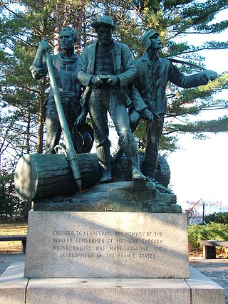
Lumberman's Monument is a monument dedicated to the workers of the early logging industry in Michigan. Standing at 14 feet, the bronze statue features a log surrounded by three figures: a timber cruiser holding a compass, a sawyer with his saw slung over his shoulder, and a river rat resting his peavey on the ground. The granite base of the statue is engraved with a memorial that reads "Erected to perpetuate the memory of the pioneer lumbermen of Michigan through whose labors was made possible the development of the prairie states." It is also inscribed with the names of the logging families who dedicated their time and efforts to the industry in the area. It was built in 1931, dedicated in 1932 and is managed by the USDA Forest Service. It is located in the northeastern part of the Lower Peninsula of Michigan along the Au Sable River within Huron-Manistee National Forests. Access to the park is on River Road, which intersects M-65 west of Oscoda, Michigan. Monument Road, from East Tawas, also leads directly to the monument, which is in Oscoda Township in Iosco County. The monument is part of the River Road Scenic Byway, a 22-mile (35 km) drive between Oscoda and South Branch that runs parallel with the beautiful Au Sable River. It is a designated National Scenic Byway.

Fairview is an unincorporated community in Oscoda County in the U.S. state of Michigan. It is located within Comins Township at the intersection of highways M-33 and M-72 at 44°43′30″N84°03′04″W.

The Dead Stream Flooding State Wildlife Management Area is a protected wildlife area located in the U.S. state of Michigan. The wildlife management area centers along the Muskegon River about 2 miles (3.2 km) from its source at Houghton Lake. It incorporates rural areas in Enterprise Township within Missaukee County and Lake Township within Roscommon County for an approximate total area of 1,024 acres (4.14 km2). It is controlled and maintained by the Michigan Department of Natural Resources.

The Houghton Lake Flats Flooding State Wildlife Management Area is a protected wildlife area located in rural Lake Township within Roscommon County in the U.S. state of Michigan. The wildlife management area incorporates 1,830 acres (7.41 km2) of artificially restored marsh and wetlands just west of Houghton Lake.

Backus Creek State Game Area is a state game area within Roscommon County in the U.S. state of Michigan. It incorporates 4,379 acres (17.72 km2) of hunting, recreational, and protected wildlife and wetland areas of rural Backus Township and Higgins Township. Backus Creek State Game Area is administered by the Michigan Department of Natural Resources (MDNR).


