
The Au Sable River in Michigan, United States runs approximately 138 miles (222 km) through the northern Lower Peninsula, through the towns of Grayling and Mio, and enters Lake Huron at the town of Oscoda. It is considered one of the best brown trout fisheries east of the Rockies and has been designated a blue ribbon trout stream by the Michigan Department of Natural Resources. In French, au sable literally means "at the sand." A 1795 map calls it the Beauais River.
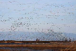
The Sacramento National Wildlife Refuge Complex is part of the United States system of National Wildlife Refuges (NWR). It is located in northern California, in the valley of the Sacramento River.

Kirtland's warbler, which is recorded to have been known by local folk in Michigan by the common name jack pine bird, and is also known as the jack pine warbler, is a small songbird of the New World warbler family (Parulidae), named after Jared Potter Kirtland, an Ohio doctor and amateur naturalist. Nearly extinct just 50 years ago, it is well on its way to recovery. It requires large areas, greater than 160 acres, of dense young jack pine for its breeding habitat. This habitat was historically created by wildfire, but today is created through the harvest of mature jack pine, and planting of jack pine seedlings.

The Huron–Manistee National Forests are two separate national forests, the Huron National Forest and the Manistee National Forest, combined in 1945 for administration purposes and which comprise 978,906 acres (3,960 km2) of public lands, including 5,786 acres (23 km2) of wetlands, extending across the northern lower peninsula of Michigan. The Huron–Manistee National Forests provide recreation opportunities for visitors, habitat for fish and wildlife, and resources for local industry. The headquarters for the forests is in Cadillac, Michigan.

The Huron National Forest is a National Forest in the Lower Peninsula of Michigan. It was established in 1909 after the logging era began to decline. In 1945, it was administratively combined with the Manistee National Forest, to create the Huron-Manistee National Forest. However, these are not connected and are separate forests. It provides recreation opportunities for visitors, habitat for fish and wildlife, and resources for local industry. The headquarters for the forest is located in Cadillac, Michigan.

The Shiawassee National Wildlife Refuge is a 9,870.35 acres (39.9439 km2) National Wildlife Refuge in Saginaw County managed by the United States Fish and Wildlife Service. It is located in the central portion of the lower peninsula of the U.S. state of Michigan, approximately 25 miles (40 km) south of the Saginaw Bay in Lake Huron and five miles (8 km) south of the city of Saginaw in the county's Spaulding and James townships. It was established in 1953 to provide habitat for migratory waterfowl.

Seney is an unincorporated community in Schoolcraft County in the Upper Peninsula of Michigan, United States. The historic community began as a railroad stop in 1881. Soon after, logging companies moved into the area to lumber the white pine forests in the surrounding region. Seney soon grew to over 3,000 people. During this time, the town gained a reputation for being rowdy and dangerous due its boom economy and numerous saloons. By the end of the nineteenth century, the forests of pine in the surrounding region were depleted and the lumber companies left, shrinking the town considerably. It currently has less than 200 people.
The protected areas of Michigan come in an array of different types and levels of protection. Michigan has five units of the National Park Service system. There are 14 federal wilderness areas; the majority of these are also tribal-designated wildernesses. It has one of the largest state forest systems as well having four national forests. The state maintains a large state park system and there are also regional parks, and county, township and city parks. Still other parks on land and in the Great Lakes are maintained by other governmental bodies. Private protected areas also exist in the state, mainly lands owned by land conservancies.

The Lower Suwannee National Wildlife Refuge (LSNWR) is part of the United States National Wildlife Refuge System. It is located in southeastern Dixie and northwestern Levy counties on the western coast of Florida, approximately fifty miles southwest of the city of Gainesville.
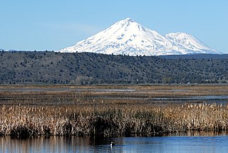
The Lower Klamath National Wildlife Refuge is a National Wildlife Refuge of the United States on the border between California and Oregon. It is operated by the United States Fish and Wildlife Service. The refuge was designated a National Historic Landmark on October 16, 1965.

The Seney National Wildlife Refuge is a managed wetland in Schoolcraft County in the U.S. state of Michigan. It has an area of 95,212 acres (385 km2). It is bordered by M-28 and M-77. The nearest town of any size is Seney, Michigan. The refuge contains the Seney Wilderness Area and the Strangmoor Bog National Natural Landmark within its boundaries.

The Michigan Islands National Wildlife Refuge is a designation for eight Michigan islands in the North American Great Lakes. Owned by the United States federal government, they were set aside for ecosystem protection purposes by President Franklin D. Roosevelt 1943.
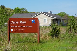
The Cape May National Wildlife Refuge is a protected area on the Cape May Peninsula in Cape May County, New Jersey. It is part of the National Wildlife Refuge System and managed by the United States Fish and Wildlife Service. Established in January 1989 with 90 acres (0.36 km2) acquired from the Nature Conservancy, it has since grown to more than 11,000 acres (45 km2) in size, and plans call for its further expansion to more than 21,200 acres (86 km2). It comprises three distinct and non-contiguous units: the Delaware Bay Division, the Great Cedar Swamp Division and the Two Mile Beach Unit. Located in the Middle Atlantic coastal forests ecoregion, the cape provides habitat for large numbers of migratory birds.
Lacreek National Wildlife Refuge is a National Wildlife Refuge of the United States located in South Dakota. It covers 16,410 acres (66.4 km2) and is managed by the United States Fish and Wildlife Service.

The Whitefish Point Light is a lighthouse in the Upper Peninsula of Michigan and the oldest and arguably the most important operating light on Lake Superior. All vessels entering and leaving Lake Superior must pass the light. It stands on Whitefish Point, on the treacherous southern shoreline of Lake Superior known as the "Graveyard of the Great Lakes", which has more shipwrecks than any other area of the lake.

Fairview is an unincorporated community in Oscoda County in the U.S. state of Michigan. It is located within Comins Township at the intersection of highways M-33 and M-72 at 44°43′30″N84°03′04″W.
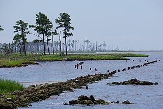
The Swanquarter National Wildlife Refuge is located in Hyde County, North Carolina near the village of Swan Quarter. The area is a federally protected land and home to many species of wildlife and waterfowl. The refuge is administered from the nearby Mattamuskeet National Wildlife Refuge. The refuge has a total area of 16,411 acres (66.41 km2).
The Harbor Island National Wildlife Refuge is a 695-acre (281 ha) horseshoe-shaped island and National Wildlife Refuge in Potagannissing Bay north of Drummond Island in the U.S. state of Michigan. The island was acquired in 1983 by the United States Fish and Wildlife Service from its previous owner, the Nature Conservancy, and set aside as a refuge. It is located in Drummond Township, in Chippewa County.

Wapack National Wildlife Refuge is a National Wildlife Refuge of the United States located in southern New Hampshire. It was the state's first refuge and was established through a donation in 1972. The 1,672-acre (677 ha) refuge is located about 20 miles (32 km) west of Nashua, New Hampshire and encompasses the 2,278-foot (694 m) North Pack Monadnock Mountain.
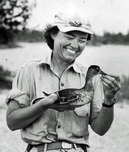
Elizabeth Brown Losey (1912–2005) was an American conservationist who is recognized as being the first female refuge biologist.
